Montgomery County, Illinois

Last updated

Montgomery County
Montgomery County Courthouse, Hillsboro.jpg
Map of Illinois highlighting Montgomery County.svg
Location within the U.S. state of Illinois
Illinois in United States.svg
Illinois's location within the U.S.
Coordinates: 39°14′N89°29′W / 39.23°N 89.48°W / 39.23; -89.48
CountryFlag of the United States.svg United States
StateFlag of Illinois.svg  Illinois
Founded1821
Named for Richard Montgomery
Seat Hillsboro
Largest city Litchfield
Area
  Total710 sq mi (1,800 km2)
  Land704 sq mi (1,820 km2)
  Water6.0 sq mi (16 km2)  0.8%
Population
 (2020)
  Total28,288
  Density40/sq mi (15/km2)
Time zone UTC−6 (Central)
  Summer (DST) UTC−5 (CDT)
Congressional district 15th
Website www.montgomeryco.com

Montgomery County is a county located in the U.S. state of Illinois. According to the 2020 census, it had a population of 28,288. [1] Its county seat is Hillsboro. [2] [3]

Contents

History

Montgomery County was formed in 1821 out of Bond and Madison counties. It was named in honor of Richard Montgomery, an American Revolutionary War general killed in 1775 while attempting to capture Quebec City, Canada. [4] Perrin's 1882 History of Montgomery County relates that the county was named in honor of Gen. Montgomery, but goes on to say that "others are dubious as to whence it received its name."

Geography

According to the U.S. Census Bureau, the county has a total area of 710 square miles (1,800 km2), of which 704 square miles (1,820 km2) is land and 6.0 square miles (16 km2) (0.8%) is water. [5]

Climate and weather

Hillsboro, Illinois
Climate chart (explanation)
J
F
M
A
M
J
J
A
S
O
N
D
 
 
2.2
 
 
37
21
 
 
2
 
 
44
26
 
 
3.6
 
 
56
35
 
 
4.2
 
 
68
45
 
 
4.3
 
 
78
55
 
 
4.1
 
 
87
64
 
 
3.5
 
 
91
68
 
 
3.5
 
 
89
66
 
 
3.2
 
 
82
58
 
 
2.9
 
 
71
47
 
 
3.8
 
 
55
37
 
 
3
 
 
42
26
Average max. and min. temperatures in °F
Precipitation totals in inches
Source: The Weather Channel [6]
Metric conversion
J
F
M
A
M
J
J
A
S
O
N
D
 
 
55
 
 
3
−6
 
 
51
 
 
7
−3
 
 
90
 
 
13
2
 
 
106
 
 
20
7
 
 
109
 
 
26
13
 
 
103
 
 
31
18
 
 
88
 
 
33
20
 
 
90
 
 
32
19
 
 
80
 
 
28
14
 
 
74
 
 
22
8
 
 
97
 
 
13
3
 
 
76
 
 
6
−3
Average max. and min. temperatures in °C
Precipitation totals in mm

In recent years, average temperatures in the county seat of Hillsboro have ranged from a low of 21 °F (−6 °C) in January to a high of 91 °F (33 °C) in July, although a record low of −22 °F (−30 °C) was recorded in February 1905 and a record high of 114 °F (46 °C) was recorded in July 1954. Average monthly precipitation ranged from 2.00 inches (51 mm) in February to 4.31 inches (109 mm) in May. [6]

Adjacent counties

Transportation

Major highways

Airports

Litchfield Municipal Airport is located in Montgomery County, two nautical miles (3.7 km) southwest of the central business district of Litchfield, Illinois.

Demographics

Historical population
CensusPop.Note
1830 2,953
1840 4,49052.0%
1850 6,27739.8%
1860 13,979122.7%
1870 25,31481.1%
1880 28,07810.9%
1890 30,0036.9%
1900 30,8362.8%
1910 35,31114.5%
1920 41,40317.3%
1930 35,278−14.8%
1940 34,499−2.2%
1950 32,460−5.9%
1960 31,244−3.7%
1970 30,260−3.1%
1980 31,6864.7%
1990 30,728−3.0%
2000 30,652−0.2%
2010 30,104−1.8%
2020 28,288−6.0%
2023 (est.)27,663 [7] −2.2%
U.S. Decennial Census [8]
1790-1960 [9] 1900-1990 [10]
1990-2000 [11] 2010 [12]

As of the 2010 United States Census, there were 30,104 people, 11,652 households, and 7,806 families living in the county. [13] The population density was 42.8 inhabitants per square mile (16.5/km2). There were 13,080 housing units at an average density of 18.6 per square mile (7.2/km2). [5] The racial makeup of the county was 95.1% white, 3.2% black or African American, 0.4% Asian, 0.2% American Indian, 0.5% from other races, and 0.7% from two or more races. Those of Hispanic or Latino origin made up 1.5% of the population. [13] In terms of ancestry, 27.8% were German, 11.2% were Irish, 10.1% were English, and 9.8% were American. [14]

Of the 11,652 households, 29.8% had children under the age of 18 living with them, 51.7% were married couples living together, 10.2% had a female householder with no husband present, 33.0% were non-families, and 28.4% of all households were made up of individuals. The average household size was 2.38 and the average family size was 2.87. The median age was 41.9 years. [13]

The median income for a household in the county was $40,864 and the median income for a family was $56,945. Males had a median income of $40,749 versus $29,426 for females. The per capita income for the county was $21,700. About 10.9% of families and 14.0% of the population were below the poverty line, including 22.7% of those under age 18 and 7.4% of those age 65 or over. [15]

Communities

Cities

Villages

Unincorporated communities

Townships

Former Townships

Notable people

Politics

United States presidential election results for Montgomery County, Illinois [16]
Year Republican Democratic Third party
No.%No.%No.%
2020 9,54469.36%3,90528.38%3122.27%
2016 8,63066.50%3,50427.00%8446.50%
2012 6,77655.60%5,05841.50%3542.90%
2008 6,15047.64%6,49150.28%2682.08%
2004 6,85152.99%5,97946.24%1000.77%
2000 6,22647.55%6,54249.97%3252.48%
1996 4,77037.76%6,33850.18%1,52312.06%
1992 4,40729.70%7,42450.04%3,00620.26%
1988 6,38846.43%7,29353.01%780.57%
1984 8,19156.08%6,36043.55%540.37%
1980 8,94758.04%5,72137.11%7474.85%
1976 7,37946.56%8,32252.51%1470.93%
1972 9,02556.71%6,85843.10%300.19%
1968 7,54746.19%7,31844.79%1,4749.02%
1964 6,42537.78%10,58162.22%00.00%
1960 9,17850.97%8,81548.95%140.08%
1956 9,94556.36%7,69243.59%80.05%
1952 10,01454.95%8,19544.97%160.09%
1948 8,34850.73%7,90248.02%2051.25%
1944 8,98952.74%7,85546.08%2011.18%
1940 10,49751.65%9,65447.50%1740.86%
1936 8,14042.92%10,13253.43%6923.65%
1932 5,94534.71%10,45661.05%7254.23%
1928 8,99954.29%7,39244.60%1841.11%
1924 8,02247.26%5,62233.12%3,33119.62%
1920 7,42952.92%4,75633.88%1,85413.21%
1916 7,06544.65%7,90349.94%8565.41%
1912 1,47618.20%3,70545.69%2,92836.11%
1908 3,78245.64%3,90947.17%5967.19%
1904 3,48947.98%3,18143.74%6028.28%
1900 3,58345.43%4,07851.71%2252.85%
1896 3,62246.02%4,11752.31%1321.68%
1892 2,93541.01%3,70751.80%5157.20%

See also

Related Research Articles

<span class="mw-page-title-main">Christian County, Illinois</span> County in Illinois, United States

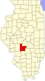
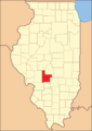
Christian County is a county located in the U.S. state of Illinois. As of the 2020 census, the population was 34,032. Its county seat is Taylorville.

<span class="mw-page-title-main">Donnellson, Illinois</span> Village in Illinois, United States

Donnellson is a village in Montgomery and Bond counties, Illinois, United States. The population was 153 as of the 2020 census, down from 210 in 2010.

<span class="mw-page-title-main">Harvel, Illinois</span> Village in Illinois, United States

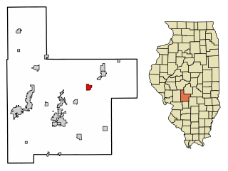
Harvel is a village in Christian and Montgomery counties in the U.S. state of Illinois. The population was 178 at the 2020 census, down from 223 in 2010.

<span class="mw-page-title-main">Coalton, Illinois</span> Village in Illinois, United States

Coalton is a village in Montgomery County, Illinois, United States. The population was 317 at the 2020 census.

<span class="mw-page-title-main">Fillmore, Illinois</span> Village in Illinois, United States

Fillmore is a village in Montgomery County, Illinois, United States. The population was 305 at the 2020 census.

<span class="mw-page-title-main">Hillsboro, Illinois</span> City in Illinois, United States

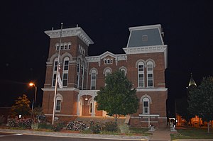
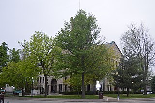
Hillsboro is a city in and the county seat of Montgomery County, Illinois, United States. The population was 5,902 at the 2020 census.

<span class="mw-page-title-main">Litchfield, Illinois</span> City in Illinois, United States

Litchfield is a city in Montgomery County, Illinois, United States. The population was 6,605 at the 2020 census. It is located in South Central Illinois, south of Springfield, the state capital.

<span class="mw-page-title-main">Nokomis, Illinois</span> City in Illinois, United States

Nokomis is a city in Montgomery County, Illinois, United States. The population was 2,142 at the 2020 census.

<span class="mw-page-title-main">Raymond, Illinois</span> Village in Illinois, United States

Raymond is a village in Montgomery County, Illinois, United States. The population was 949 at the 2020 census.

<span class="mw-page-title-main">Schram City, Illinois</span> Village in Illinois, United States

Schram City is a village in Montgomery County, Illinois, United States. The population was 563 at the 2020 census.

<span class="mw-page-title-main">Taylor Springs, Illinois</span> Village in Illinois, United States

Taylor Springs is a village in Montgomery County, Illinois, United States. The population was 724 at the 2020 census.

<span class="mw-page-title-main">Walshville, Illinois</span> Village in Illinois, United States

Walshville is a small village in Montgomery County, Illinois, United States. The population was 61 at the 2020 census.

<span class="mw-page-title-main">Witt, Illinois</span> City in Illinois, United States

Witt is a city in Montgomery County, Illinois, United States. The population was 785 at the 2020 census, down from 903 in 2010.

Hume is a town in Allegany County, New York, United States. The population was 2,094 at the 2020 census. The town is on the northern border of Allegany County.

<span class="mw-page-title-main">Concord Township, Bureau County, Illinois</span> Township in Illinois, United States

Concord Township is one of twenty-five townships in Bureau County, Illinois, USA. As of the 2020 census, its population was 1,423 and it contained 738 housing units.

<span class="mw-page-title-main">King Township, Christian County, Illinois</span> Township in Illinois, United States

King Township is one of seventeen townships in Christian County, Illinois, USA. As of the 2020 census, its population was 198 and it contained 94 housing units.

<span class="mw-page-title-main">Rosamond Township, Christian County, Illinois</span> Township in Illinois, United States

Rosamond Township is one of seventeen townships in Christian County, Illinois, USA. As of the 2020 census, its population was 345 and it contained 162 housing units.

<span class="mw-page-title-main">Grisham Township, Montgomery County, Illinois</span> Township in Illinois, United States

Grisham Township is located in Montgomery County, Illinois, United States. As of the 2010 census, its population was 629 and it contained 318 housing units.

<span class="mw-page-title-main">South Litchfield Township, Montgomery County, Illinois</span> Township in Illinois, United States

South Litchfield Township is located in Montgomery County, Illinois, United States. As of the 2010 census, its population was 3,408 and it contained 1,579 housing units.

<span class="mw-page-title-main">Walshville Township, Montgomery County, Illinois</span> Township in Illinois, United States

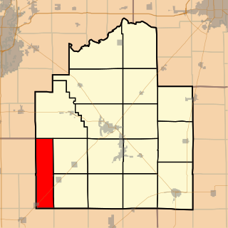
Walshville Township is located in Montgomery County, Illinois, United States. As of the 2010 census, its population was 347 and it contained 162 housing units.

References

  1. "Montgomery County, Illinois". United States Census Bureau . Retrieved June 10, 2023.
  2. "Hillsboro Illinois". City of Hillsboro. Retrieved February 15, 2012.
  3. "Find a County". National Association of Counties. Retrieved June 7, 2011.
  4. Allan H. Keith, Historical Stories: About Greenville and Bond County, IL. Consulted on August 15, 2007.
  5. 1 2 "Population, Housing Units, Area, and Density: 2010 - County". United States Census Bureau. Archived from the original on February 12, 2020. Retrieved July 12, 2015.
  6. 1 2 "Monthly Averages for Hillsboro, Illinois". The Weather Channel. Retrieved January 27, 2011.
  7. "Annual Estimates of the Resident Population for Counties: April 1, 2020 to July 1, 2023". United States Census Bureau. Retrieved April 2, 2024.
  8. "U.S. Decennial Census". United States Census Bureau. Retrieved July 7, 2014.
  9. "Historical Census Browser". University of Virginia Library. Retrieved July 7, 2014.
  10. "Population of Counties by Decennial Census: 1900 to 1990". United States Census Bureau. Retrieved July 7, 2014.
  11. "Census 2000 PHC-T-4. Ranking Tables for Counties: 1990 and 2000" (PDF). United States Census Bureau. Retrieved July 7, 2014.
  12. "State & County QuickFacts". United States Census Bureau. Archived from the original on June 7, 2011. Retrieved July 7, 2014.
  13. 1 2 3 "DP-1 Profile of General Population and Housing Characteristics: 2010 Demographic Profile Data". United States Census Bureau. Archived from the original on February 13, 2020. Retrieved July 12, 2015.
  14. "DP02 SELECTED SOCIAL CHARACTERISTICS IN THE UNITED STATES – 2006-2010 American Community Survey 5-Year Estimates". United States Census Bureau. Archived from the original on February 13, 2020. Retrieved July 12, 2015.
  15. "DP03 SELECTED ECONOMIC CHARACTERISTICS – 2006-2010 American Community Survey 5-Year Estimates". United States Census Bureau. Archived from the original on February 13, 2020. Retrieved July 12, 2015.
  16. Leip, David. "Dave Leip's Atlas of U.S. Presidential Elections". uselectionatlas.org. Retrieved November 11, 2018.

39°14′N89°29′W / 39.23°N 89.48°W / 39.23; -89.48