Alexander County | |
---|---|
Coordinates: 37°11′N89°20′W / 37.19°N 89.34°W | |
Country | United States |
State | Illinois |
Founded | 1819 |
Named for | William M. Alexander |
Seat | Cairo |
Largest city | Cairo |
Area | |
• Total | 253 sq mi (660 km2) |
• Land | 236 sq mi (610 km2) |
• Water | 17 sq mi (40 km2) 6.8% |
Population (2020) | |
• Total | 5,240 |
• Estimate (2023) | 4,695 |
• Density | 21/sq mi (8.0/km2) |
Time zone | UTC−6 (Central) |
• Summer (DST) | UTC−5 (CDT) |
Congressional district | 12th |
Website | www |
Alexander County is the southernmost and southwesternmost county in the U.S. state of Illinois. As of the 2020 census, the population was 5,240. [1] Its county seat is Cairo [2] and its western boundary is formed by the Mississippi River.
Alexander County is part of the Cape Girardeau, MO-IL Metropolitan Statistical Area which is made up of jurisdictions on both sides of the Mississippi River.
Alexander County was organized from part of Union County in 1819. It was named for William M. Alexander, a physician who practiced in the town of America (the first county seat). [3] Alexander was elected as a representative to the state House, where he became Speaker of the Illinois House of Representatives in 1822.
The county was initially developed for agriculture and settled by numerous migrants from the Upper South. The county seat was moved to Unity in 1833, then to Thebes in 1843, and finally to Cairo in 1860. America, the first county seat, is now within Pulaski County, which was formed from Alexander and Johnson counties in 1843. [4]
Settled largely by white migrants from the Upland South, southern Illinois had many racial attitudes of the South. As African Americans settled in Cairo to seek jobs on steamboats, ferries, in shipping and railroads, there were tensions between the racial groups. White residents sometimes used violence and terrorism, as well as discrimination, to keep black residents in second-class positions. They excluded them from the city government and the police and fire departments, and relatively few African Americans were hired to work in the local stores.
There were three lynchings of blacks in Alexander County in the years between Reconstruction and the early 20th century. The county had the second-highest number of lynchings of African Americans in all of Illinois. [5] The most notorious of these was the lynching of Will James before a crowd of white spectators estimated at 10,000, in the county seat of Cairo on November 11, 1909. James was accused of murdering a young white woman. Later that same evening, the mob lynched a white man named Henry Salzner, hanging him in the courthouse square for allegedly killing his wife. Neither man had had a trial, nor was anyone ever prosecuted for the lynchings, even though Illinois had passed an anti-lynching law four years earlier. [6]
According to the U.S. Census Bureau, the county has a total area of 253 square miles (660 km2), of which 236 square miles (610 km2) is land and 17 square miles (44 km2) (6.8%) is water. [7] Its borders are partly defined by the Mississippi River and the Ohio River. The lowest point in the state of Illinois is located on the Mississippi River in Cairo in Alexander County, where it flows out of Illinois and into Kentucky.
Cairo, Illinois | ||||||||||||||||||||||||||||||||||||||||||||||||||||||||||||
---|---|---|---|---|---|---|---|---|---|---|---|---|---|---|---|---|---|---|---|---|---|---|---|---|---|---|---|---|---|---|---|---|---|---|---|---|---|---|---|---|---|---|---|---|---|---|---|---|---|---|---|---|---|---|---|---|---|---|---|---|
Climate chart (explanation) | ||||||||||||||||||||||||||||||||||||||||||||||||||||||||||||
| ||||||||||||||||||||||||||||||||||||||||||||||||||||||||||||
|
In recent years, average temperatures in the county seat of Cairo have ranged from a low of 26 °F (−3 °C) in January to a high of 90 °F (32 °C) in July, although a record low of −12 °F (−24 °C) was recorded in January 1985 and a record high of 104 °F (40 °C) was recorded in June 1954. Average monthly precipitation ranged from 3.04 inches (77 mm) in September to 4.76 inches (121 mm) in May. [8]
The Tamms Correctional Center, a now shuttered super-maximum correctional facility operated by the Illinois Department of Corrections, was located in Tamms, [9] [10] as was the State of Illinois execution chamber. [11] Prior to the January 11, 2003, commutation of death row sentences, male death row inmates were housed in Tamms, Menard, and Pontiac correctional centers. After that date, only Pontiac continued to host the male death row. [12] On January 4, 2013, after years of controversy over inmate conditions, the prison officially closed, negatively impacting the county's economy. [13] [14] [15]
In late September 2009, press reports indicated that the Alexander County Sheriff's office had five of its seven squad cars repossessed as payments had not been made. The sheriff once had 29 deputies, but was reduced to just five at the time of the reports. The Illinois State Police have provided assistance to the county with additional patrols. [16]
Census | Pop. | Note | %± |
---|---|---|---|
1820 | 626 | — | |
1830 | 1,390 | 122.0% | |
1840 | 3,313 | 138.3% | |
1850 | 2,484 | −25.0% | |
1860 | 4,707 | 89.5% | |
1870 | 10,564 | 124.4% | |
1880 | 14,808 | 40.2% | |
1890 | 16,563 | 11.9% | |
1900 | 19,384 | 17.0% | |
1910 | 22,741 | 17.3% | |
1920 | 23,980 | 5.4% | |
1930 | 22,542 | −6.0% | |
1940 | 25,496 | 13.1% | |
1950 | 20,316 | −20.3% | |
1960 | 16,061 | −20.9% | |
1970 | 12,015 | −25.2% | |
1980 | 12,264 | 2.1% | |
1990 | 10,626 | −13.4% | |
2000 | 9,590 | −9.7% | |
2010 | 8,238 | −14.1% | |
2020 | 5,240 | −36.4% | |
2023 (est.) | 4,695 | −10.4% | |
U.S. Decennial Census [17] 1790-1960 [18] 1900-1990 [19] 1990-2000 [20] 2010-2020 [21] 2020 [1] |
As of the 2010 United States Census, there were 8,238 people, 3,329 households, and 2,093 families residing in the county. [22] The population density was 35.0 inhabitants per square mile (13.5/km2). There were 4,006 housing units at an average density of 17.0 per square mile (6.6/km2). [7] The racial makeup of the county was 60.9% white, 35.4% black or African American, 0.3% American Indian, 0.2% Asian, 0.1% Pacific islander, 1.4% from other races, and 1.7% from two or more races. Those of Hispanic or Latino origin made up 1.9% of the population. [22] In terms of ancestry, 13.9% were German, 6.8% were Irish, 5.3% were English, and 4.7% were American. [23]
Of the 3,329 households, 29.6% had children under the age of 18 living with them, 39.6% were married couples living together, 18.5% had a female householder with no husband present, 37.1% were non-families, and 33.6% of all households were made up of individuals. The average household size was 2.31 and the average family size was 2.94. The median age was 41.1 years. [22]
The median income for a household in the county was $28,833 and the median income for a family was $44,699. Males had a median income of $35,880 versus $25,743 for females. The per capita income for the county was $15,858. About 11.8% of families and 20.1% of the population were below the poverty line, including 33.1% of those under age 18 and 14.7% of those age 65 or over. [24]
Between 2010 and 2020, the population of Alexander County decreased to 5,240. The 36.4% decline was the largest of any of the 3,138 U.S. counties. [25] Although the population of the county had been decreasing for decades, the closure of the Tamms Correctional Center in 2013 probably caused an acceleration of the decline in the 2010s. [14]
Note: the US Census treats Hispanic/Latino as an ethnic category. This table excludes Latinos from the racial categories and assigns them to a separate category. Hispanics/Latinos can be of any race.
Race | Pop 2010 | Pop 2020 | % 2010 | % 2020 |
---|---|---|---|---|
White (NH) | 4,983 | 3,274 | 60.49% | 62.48% |
Black or African American (NH) | 2,908 | 1,612 | 35.3% | 30.76% |
Native American or Alaska Native (NH) | 25 | 22 | 0.3% | 0.42% |
Asian (NH) | 16 | 6 | 0.19% | 0.11% |
Pacific Islander (NH) | 6 | 0 | 0.07% | 0.0% |
Some Other Race (NH) | 5 | 8 | 0.06% | 0.15% |
Mixed/Multi-Racial (NH) | 140 | 236 | 1.7% | 4.5% |
Hispanic or Latino | 155 | 82 | 1.88% | 1.56% |
Total | 8,238 | 5,240 |
As of the 2020 United States census, there were 5,240 people, 2,154 households, and 1,357 families residing in the county.
Here is a list of school districts with any territory in the county, no matter how slight, even if the schools and/or administrative offices are located in other counties: [28]
Alexander County is unique among antebellum free state rural counties in having a postbellum political history largely determined by a previously disfranchised black electorate. It is most similar in this respect to – though still substantially different from – some counties of the south and the Eastern Shore of Maryland. The county was thus solidly Republican until the New Deal, and gradually turned solidly Democratic up through the presidency of Bill Clinton.[ citation needed ]
In the twenty-first century, the county has shown a trend towards the GOP due to large-scale black emigration and a rapid swing of its Caucasian population toward Republican candidates.[ citation needed ] This became clear in 2016, when Donald Trump carried the county by 8.3 points—a hard swing from favorite son Obama's 13.6-point victory four years earlier, and the first time the county voted Republican since 1972. An even harder swing was taken in 2020, when he carried Alexander again by 14.2 points, even as the nation as a whole trended slightly leftward. Furthermore, Dick Durbin lost the county in the simultaneous U.S. Senate election, making it his first Senate election in which he failed to win the county and the first Senate election since 1972 in which a Republican won the county.[ citation needed ]
Despite the rightward swing taken by the county, the city and county seat of Cairo remains overwhelmingly Democratic.[ citation needed ]
Year | Republican | Democratic | Third party | |||
---|---|---|---|---|---|---|
No. | % | No. | % | No. | % | |
2020 | 1,486 | 56.70% | 1,114 | 42.50% | 21 | 0.80% |
2016 | 1,496 | 53.05% | 1,262 | 44.75% | 62 | 2.20% |
2012 | 1,487 | 42.47% | 1,965 | 56.13% | 49 | 1.40% |
2008 | 1,692 | 42.87% | 2,189 | 55.46% | 66 | 1.67% |
2004 | 1,831 | 47.28% | 2,016 | 52.05% | 26 | 0.67% |
2000 | 1,588 | 39.48% | 2,357 | 58.60% | 77 | 1.91% |
1996 | 1,212 | 28.16% | 2,753 | 63.96% | 339 | 7.88% |
1992 | 1,301 | 29.83% | 2,566 | 58.83% | 495 | 11.35% |
1988 | 1,954 | 41.90% | 2,693 | 57.75% | 16 | 0.34% |
1984 | 2,574 | 47.08% | 2,872 | 52.53% | 21 | 0.38% |
1980 | 2,650 | 46.67% | 2,925 | 51.51% | 103 | 1.81% |
1976 | 2,349 | 41.52% | 3,246 | 57.37% | 63 | 1.11% |
1972 | 3,669 | 59.09% | 2,482 | 39.97% | 58 | 0.93% |
1968 | 2,540 | 36.63% | 2,929 | 42.24% | 1,465 | 21.13% |
1964 | 2,895 | 37.80% | 4,763 | 62.20% | 0 | 0.00% |
1960 | 4,143 | 47.96% | 4,477 | 51.83% | 18 | 0.21% |
1956 | 4,425 | 51.38% | 4,167 | 48.38% | 21 | 0.24% |
1952 | 5,219 | 54.63% | 4,305 | 45.06% | 29 | 0.30% |
1948 | 4,561 | 49.05% | 4,641 | 49.91% | 96 | 1.03% |
1944 | 4,792 | 49.73% | 4,767 | 49.47% | 78 | 0.81% |
1940 | 6,260 | 48.20% | 6,591 | 50.75% | 137 | 1.05% |
1936 | 5,553 | 43.89% | 6,972 | 55.10% | 128 | 1.01% |
1932 | 4,729 | 44.90% | 5,653 | 53.67% | 151 | 1.43% |
1928 | 5,666 | 61.24% | 3,558 | 38.46% | 28 | 0.30% |
1924 | 4,465 | 58.10% | 2,639 | 34.34% | 581 | 7.56% |
1920 | 5,287 | 61.92% | 3,167 | 37.09% | 85 | 1.00% |
1916 | 5,395 | 56.76% | 3,940 | 41.45% | 170 | 1.79% |
1912 | 2,003 | 41.79% | 1,936 | 40.39% | 854 | 17.82% |
1908 | 3,790 | 63.85% | 2,027 | 34.15% | 119 | 2.00% |
1904 | 3,203 | 63.11% | 1,686 | 33.22% | 186 | 3.67% |
1900 | 2,790 | 60.76% | 1,760 | 38.33% | 42 | 0.91% |
1896 | 2,802 | 60.35% | 1,813 | 39.05% | 28 | 0.60% |
1892 | 2,053 | 53.93% | 1,674 | 43.97% | 80 | 2.10% |
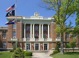
Scott County is located in the southeastern portion of the U.S. state of Missouri. As of the 2020 census, the population was 38,059. Its county seat is Benton. The county was organized in 1821 and named for U.S. Representative John Scott, the first federal representative from Missouri. Scott County comprises the Sikeston, MO Micropolitan Statistical Area, which is also included in the Cape Girardeau-Sikeston, MO-IL Combined Statistical Area. The county is home to Scott County Central High School, which has won 18 state championships in boys basketball—the most of any high school in the state.
Cape Girardeau County is located in the southeastern part of the U.S. state of Missouri; its eastern border is formed by the Mississippi River. At the 2020 census, the population was 81,710. The county seat is Jackson, the first city in the US to be named in honor of President Andrew Jackson. Officially organized on October 1, 1812, the county is named after Ensign Sieur Jean Baptiste de Girardot, an official of the French colonial years. The "cape" in the county's name is named after a former promontory rock overlooking the Mississippi River; this feature was demolished during railroad construction. Cape Girardeau County is the hub of the Cape Girardeau–Jackson metropolitan area. Its largest city is Cape Girardeau.
Lauderdale County is a county located on the eastern border of the U.S. state of Mississippi. As of the 2020 census, the population was 72,984. The county seat is Meridian. The county is named for Colonel James Lauderdale, who was killed at the Battle of New Orleans in the War of 1812. Lauderdale County is included in the Meridian, MS Micropolitan Statistical Area.
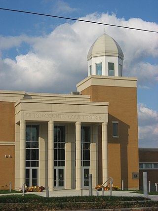
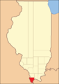
Union County is a county located in the U.S. state of Illinois. According to the 2020 United States Census, it had a population of 17,244. Its county seat is Jonesboro. It is located in the southern portion of Illinois known locally as "Little Egypt".
St. Clair County is the ninth most populous county in Illinois. Located directly east of St. Louis, the county is part of the Metro East region of the Greater St. Louis metropolitan area in southern Illinois. As of the 2020 United States census, St. Clair County had a population of 257,400, making it the third most populous county in Illinois outside the Chicago metropolitan area. Belleville is the county’s seat and largest city.
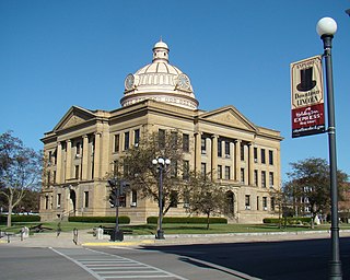
Randolph County is a county located in the U.S. state of Illinois. According to the 2020 census, it had a population of 30,163. Its county seat is Chester.
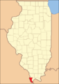
Pulaski County is a county located in the U.S. state of Illinois. According to the 2020 census, it had a population of 5,193. Its county seat is Mound City. Its largest city is Mounds. It is located along the Ohio River in the southwestern portion of the state, known locally as "Little Egypt".
Logan County is a county located in the U.S. state of Illinois. According to the 2020 census, it had a population of 27,987. Its county seat is Lincoln.
Livingston County is a county located in the U.S. state of Illinois. According to the 2020 census, it has a population of 35,815. Its county seat is Pontiac. Livingston County comprises the Pontiac, IL Micropolitan Statistical Area, which is combined with the Bloomington–Normal metropolitan statistical area as the Bloomington-Pontiac, IL Combined Statistical Area in upper portion of Central Illinois.
Brown County is a county located in the U.S. state of Illinois. As of the 2020 census, the population was 6,244. Its county seat is Mount Sterling.
Pulaski County is a county located in the central portion of the U.S. state of Georgia. As of the 2020 census, the population was 9,855. The county seat is Hawkinsville.
Pulaski County is a county in the U.S. state of Arkansas. With a population of 399,125 as of the 2020 United States Census, it is the most populous county in Arkansas. The county is included in the Little Rock–North Little Rock–Conway metropolitan area. Its county seat is Little Rock, which is also Arkansas's capital and largest city.
Cairo is the southernmost city in Illinois and the county seat of Alexander County. A river city, Cairo has the lowest elevation of any location in Illinois and is the only Illinois city to be surrounded by levees. It is in the river-crossed area of Southern Illinois known as "Little Egypt", for which the city is named, after Egypt's capital on the Nile. The city is coterminous with Cairo Precinct.
East Cape Girardeau is a village in Alexander County, Illinois, United States. The population was 289 at the 2020 census. It is part of the Cape Girardeau–Jackson, MO-IL Metropolitan Statistical Area.
Tamms is a village in Alexander County, Illinois, United States. The population was 430 at the 2020 census, down from 632 at the 2010 census. It is part of the Cape Girardeau–Jackson, MO-IL Metropolitan Statistical Area.
Thebes is a village in and the former county seat of Alexander County, Illinois, United States. The population was 208 at the 2020 census, down from 436 at the 2010 census. It is part of the Cape Girardeau–Jackson, MO-IL Metropolitan Statistical Area. In 1860 the county seat was moved to Cairo, Illinois, at the confluence of the Ohio and Mississippi rivers.
Mound City is a city and the county seat of Pulaski County, Illinois, United States. It is located along the Ohio River just north of its confluence with the Mississippi River. As of the 2010 census, the city population was 588.
Leakesville is a town in and the county seat of Greene County, Mississippi, United States. It is located along the Chickasawhay River in Greene County, Mississippi, United States. It is served by the junction of Mississippi routes 57 and 63. As of the 2010 census, the rural town population was 898, down from 1,026 at the 2000 census.
The Cape Girardeau–Jackson Metropolitan Statistical Area, as defined by the United States Census Bureau, is an area consisting of two counties in southeastern Missouri and one in southern Illinois with its core in both states. Its largest cities are the cities of Cape Girardeau and Jackson. It was upgraded from a Micropolitan Statistical Area (μSA) to a Metropolitan Statistical Area (MSA) by the Office of Management and Budget on November 20, 2008.
Unity, also known as Hodges Park Station, is an unincorporated community and census-designated place in Alexander County, Illinois, United States. Illinois Route 127 passes by Unity south of Tamms. The population as of the 2020 census was 98.