Mt. Vernon was founded in 1817 by Zadok Casey, who was elected to the State Senate in 1822 and was elected lieutenant governor in 1833.[5] He served in the U.S. Congress between 1833 and 1843.[5] The town was named for George Washington's plantation, Mount Vernon, which was named for Edward Vernon, a British naval hero.[6]
When the town was founded, there was no road to it. Travelers had to get there by either following the high ground from the north or crossing the swamps from the south. In the early 19th century the Goshen Road crossed Illinois in a northwesterly direction from Old Shawneetown, Illinois to the Goshen Settlement, near what is now Edwardsville. This road was the main road in Illinois. When Mt. Vernon was first settled, the Goshen Road made a wide arc across Jefferson County, crossing Casey Creek and the Big Muddy north of Mt. Vernon, avoiding the swamps to the south, but bypassing Mt. Vernon. The road entered the county at its southeast corner. It passed through, or near, what are now Opdyke, East Salem, Idlewood, Dix and Walnut Hill. However, it was apparent to the early settlers that the town would fail without roads. In 1820–1821, Ben Hood and Carter Wilkey built a bridge over Casey Creek, to the southeast of town. This bridge was near the present bridge on Illinois Route 142. A road was built from there northwest, over ground that is now impassable, toward the old cemetery behind the modern Bethel Cemetery. Deep cuts through the old cemetery attest to the location of the road. From there the road probably followed modern Route 37 into town, somewhere shifting from 10th Street on west to 12th Street.
After the state capital was moved to Vandalia in 1819, it became apparent that a road to Vandalia was needed. A party was sent out to the northwest to mark the road. In 1823, Thomas D. Minor and William Maxwell built the "Vandalia Road", now called the "Old Centralia Road." It runs northwest out of Mt. Vernon to Walnut Hill. Although legend says that this road is crooked because of the drunken state of the surveyors, the path is probably just the natural path of a pioneer road following the terrain. After the bridge and the Vandalia Road were built, Mt. Vernon was "on the map." The bridge across Casey Creek and the Vandalia Road provided a much shorter path across Jefferson County than the original Goshen Road. The new Goshen Road soon captured most of the traffic, and Mt. Vernon became an important stop on the road west.
In 1836, Joshua Grant came to Mt. Vernon from Christian County, Kentucky with several of his sons and daughters. His family was a wealthy slave-owning family, most of whom soon moved to Arkansas, probably because slavery was illegal in Illinois. Joshua left behind several daughters and one son, Angus McNeil Grant, who soon became important in the development of the town. "Upon his arrival, there were but four or five houses in the place, and from that time to the present (1883) he has constantly and ably exerted himself in securing to it the full development of its resources." Angus M. Grant's brother, Joshua Jr. taught school in Mt. Vernon in 1838. Some sources cite him as the first schoolteacher in the town.
In 1848, in accordance with the new constitution of Illinois, the Illinois Supreme Court first Grand Division was relocated to Mt. Vernon.[7] There were three divisions total comprised for the first (southern), second (central) and third (northern) areas of the state.[8] The 5th District Appellate Court was constructed in 1854 and is still in use as the Appellate Court House. When the Supreme Court was in session, the important lawyers in Illinois, including Abraham Lincoln, gathered in Mt. Vernon to argue their cases. The lawyers gathered at the Mt. Vernon Inn, owned by Angus McNeil Grant and his in-laws, the Andersons. This building has been on the National Register of Historic Places since July 2, 1973.[9]
In the 1870s, Mt. Vernon for a time prohibited the sale of alcohol. A village called "East Mt. Vernon" was organized in 1877 to allow the sale of alcohol. A court fight eventually held that the village was organized illegally. Mt. Vernon then voted alcohol back in, and the area of East Mt. Vernon was annexed into the city.
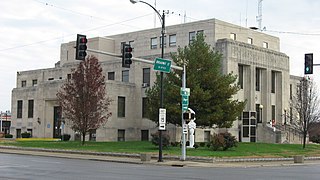
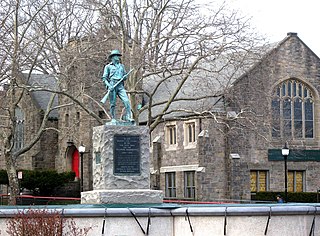
On February 19, 1888, a tornado cut a path a half mile wide through Mt. Vernon, killing 37 people and destroying more than 450 houses. The Jefferson County Courthouse was destroyed. This event was one of the first disasters to which the American Red Cross responded. Clara Barton herself directed the relief efforts.
The Mt. Vernon Car Manufacturing Company opened in 1889 after moving from Litchfield, Illinois. This relocation may have been an outgrowth of the relief efforts following the tornado. The Louisville and Nashville Railroad hauled in some 1,900 carloads of supplies for reconstruction of the town. Somehow, this effort translated into a major business building railroad cars, at first building about ten cars per day. By 1909, the car shops were producing 25 cars per day, employing more than 1000 workers, with a payroll of $60,000 per month.
20th and 21st centuries
During World War II, portions of the "Car Shops", as they had to come to be known, were converted over to wartime production, including the production of bomb casings. Around 1939, a portion of the car shops was purchased by Precision Engineering, which originally built components for locomotives. During the 1970s, this company purchased old diesel/electric railroad locomotives, which it scrapped out or refurbished. Today, the plant thrives as a hub for National Railway Equipment Company[10] which rebuilds and services diesel electric locomotives for rail lines across the globe.
In 1954, the car shops closed, causing a temporary jump in unemployment throughout the city and the 108 communities called "home" by its former employees.
The Interstate Highway System was built in the late 1950s and 1960s. The concurrency of I-57 and I-64 is along the western border of the ridgeline which divides the Big Muddy River and Casey Creek. The stack interchange on the southwest side of town complements the historic Casey Creek bridges, allowing much shorter travel times through the swamps to the east and south.
In April 2007, Mount Vernon voters elected the first female mayor[11] of the city, Mary Jane Chesley. She was sworn into office on May 7, 2007.[12]
Geography
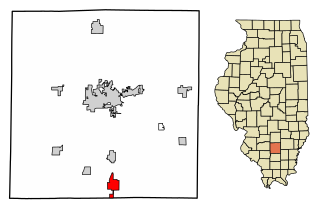
According to the 2010 census, Mount Vernon has a total area of 13.151 square miles (34.06km2), of which 13.07 square miles (33.85km2) (or 99.38%) is land and 0.081 square miles (0.21km2) (or 0.62%) is water.[13]
Mt. Vernon is located on high ground between Casey Creek and the Big Muddy River, which join south of the town in what is now Rend Lake. In pre-settlement times the area around these waterways was a swamp, a heavily forested area that was waist-deep in water during much of the winter and during wet summers. Mt. Vernon was thus often surrounded by water and swamp on three sides.
High ground was located to the north of Mt. Vernon. A ridge ran between the Big Muddy River and Casey Creek north toward what is now Dix.
There are high places both west and east of Mt. Vernon from which one can see the town as a forested point of high ground jutting out into the bottoms. These high places are: from the west, near the Woodlawn interchange off Interstate 64 and from the east, on Old Fairfield Road near Summersville School, with the highest point located on Old Route 15 right before it merges with New Route 15, near Bluford.
Climate
Climate data for Mount Vernon 3 NE, Illinois (1991–2020 normals, extremes 1895–present)
As of the census of 2020, there were 14,600 people,[18] and the 2015-2019 data estimated 6,495 households[18] residing in the city. The 2010 population density was 1,168.7 inhabitants per square mile (451.2/km2).[19] There were 7,534 housing units.[19] The racial makeup of the city was 80.6% White, 14.7% African American, 0.3% Native American, 1% Asian, 0.0% Pacific Islander, and 2.6% from two or more races. Hispanic or Latino of any race were 2.4% of the population.[19]
There were 6,702 households, out of which 25.8% had children under the age of 18 living with them, 35% of all households were married couples living together, 16.3% had a female householder with no husband present, and 43.6% were non-families. 37.6% of all households were made up of individuals, and 16.1% had someone living alone who was 65 years of age or older. The average household size was 2.23 and the average family size was 2.92.[19]
In the city the population was spread out, with 24.3% under the age of 18, 6.2% from 20 to 24, and 18% who were 65 years of age or older. The median age was 38.3 years. Males represent 46.5% of the population, and 34% of the population was male and over 18. Women were 53.5% of the population, 41% of the population being female and over 18.[19]
The median income for a household in the city was $32,549, and the median income for a family was $36,660. Males had a median income of $28,324 versus $16,497 for females. The per capita income for the city was $21,283. About 19.9% of families and 23.7% of the population were below the poverty line, including 35.4% of those under age 18 and 11.7% of that age 65 or over. 53.9% of households earn less than $35,000.[19]
Of the population over age 25, 72.7% have no college degree. 13.6% of those over 25 have no high school diploma nor equivalent. 7.6% of the population has a bachelor's degree or higher.[19]
According to the US Census, health care services and social services employ the second most people with 1,001 estimated jobs. Accommodation and food services (restaurants) are the highest employer with 1,146 estimated jobs.[19]
Crime
Data reported for 2021, by MVPD (Offenses Known to Law Enforcement)[20]
Year
State
Months
Population
Rate per 100,000
Criminal homicide
Rape
Robbery
Aggravated assault
Burglary
Larceny-theft
Motor vehicle theft
Arson
2021
IL
12
14,802
918.8
1
17
6
136
74
434
17
5
Economy
Mount Vernon hosts a 48-acre (190,000m2) facility for Continental Tire the Americas. It is also home to major distribution centers for NAPA, National Railway Equipment (NREC), ALCO and IPT (subsidiaries of NREC), along with many other smaller industries which are located in or in close proximity to the city's three industrial parks. There is discussion of creating a fourth industrial park which is to be used for distribution centers in the area of the new interchange, this park would encompass 100 acres (0.40km2) and would be eligible for Tax Increment Financing and Enterprise Zone benefits.[21]
Two new TIF (Tax Increment Financing) districts have been created, one TIF is at Exit 95 and is a conservation/industrial use. Exit 94 is an Industrial Park Conservation TIF.[22] Pepsi has built a new service and distribution center that was completed in March 2011, it is located off of the Davidson Avenue extension.
Top employers
According to Mount Vernon's 2021 Comprehensive Annual Financial Report,[23] the top employers in the city are:
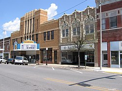
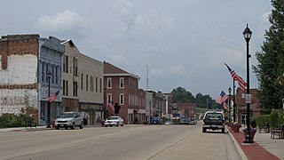
Mount Vernon is home to the Cedarhurst Center for the Arts,[24] a 90-acre visual and performing arts institution. Cedarhurst celebrates the arts year-round with visual and performing arts programs for the public. The Cedarhurst Craft Fair[25] is held yearly in early September on the grounds. In addition to its programs on property, the Mitchell Museum is located on the Cedarhurst grounds.
The city is host to an event the first Saturday of each month from April through October called Market Days.[26] This is an open-air market held near downtown and is similar to a craft fair or flea market.
There is also the Jefferson County Historical Museum and Village located within incorporated Mount Vernon. The Museum and the Village reflect life in Jefferson County from the mid 19th century to more recent years.[27]
The C.E.Brehm Memorial Public Library, built in 1905, is a source of information to the community and is located downtown.[28]
Beatles guitarist George Harrison bought a guitar from Fenton's Music store in Mt. Vernon in 1963 while he was visiting his sister in nearby Benton, Illinois. The guitar sold at auction for $657,000 in 2014.[29]
Parks and recreation
Mount Vernon has multiple community parks with varying amenities.[30]
The city of Mount Vernon uses a Council-manager government with a mayor.[31] The Mt. Vernon City Council meets regularly on the first and third Mondays each month. Meetings are moved to the following Tuesday if the first or third Monday falls on a holiday.[31]
The elective officers of the City of Mt. Vernon shall be a Mayor, four Councilmen, a City Clerk, and a City Treasurer. At the general election for City officers to be starting in January 1969 and every four years thereafter, there shall be elected a Mayor, City Clerk, City Treasurer, and two Councilmen. At the general election held in 1967 and every two years thereafter, two Councilmen shall be elected.[32]
Mt. Vernon Morning Sentinel - daily newspaper located within the city that covers local, countywide, and regional news.
Mt. Vernon Register-News - a newspaper that served Mount Vernon, and published its last edition on February 6, 2018; the following day, CNHI announced the closure of both the Register-News and the McLeansboro Times-Leader.
Radio
WMIX (AM) is an AM frequency radio station operating at 940kHz hosting a talk radio format.
WMIX-FM is an FM radio station with a country music format on 94.1MHz.
WDML is an FM radio station with an adult rock & roll format on 106.9MHz.
Television
WPXS is a television station broadcasting north of Mount Vernon operating on digital channel 21 and virtual channel 13.
The Mount Vernon Airport has a 6,500-foot main runway, fixed-base operation, terminal building and storage hangars. Charter and private aviation services are provided, as well as refueling. The facility offers Shell 100 and Jet A fuels and pilot lounge with weight and exercise room, shower and snooze rooms, wireless internet in the airport terminal, complimentary refreshments, courtesy shuttle, as well as overnight hangar reservations.[37]
MidAmerica Airport, a cargo airport approximately 45 miles from Mt. Vernon, located in Mascoutah, Illinois along Interstate 64.
Jefferson County is a county located in the southern part of the U.S. state of Illinois. According to the 2020 census, it has a population of 37,113. The county seat is Mount Vernon.
Mount Vernon is a town in Mobile County, Alabama, United States. It is part of the Mobile metropolitan area. It incorporated in 1959. At the 2020 census the population was 1,354.
Morrison is a home rule municipality in Jefferson County, Colorado, United States. The population was 396 at the 2020 census.
Altamont is a city in Effingham County, Illinois, United States. The population was 2,216 at the 2020 census. Altamont is part of the Effingham, Illinois Micropolitan Statistical Area.
Vandalia is a city in and the county seat of Fayette County, Illinois, United States. At the 2020 Census, the population was 7,458. Vandalia is on the Kaskaskia River, and 60 miles (97 km) northeast of the St. Louis area. The city served as the state capital of Illinois from 1819 until 1839, when the seat of state government moved closer to the center of the state in Springfield. In the early 19th century, Vandalia was the western terminus of the National Road from the East Coast. Since 1933, the Vandalia State House State Historic Site has sought to preserve and interpret the State House building and grounds, originally constructed in 1836.
Dix is a village in Jefferson County, Illinois, United States. The population was 461 at the 2010 census. It is part of the Mount Vernon Micropolitan Statistical Area.
Ina is a village in Jefferson County, Illinois, United States. The population was 2,338 as of the 2010 census. It is part of the Mount Vernon Micropolitan Statistical Area.
Waltonville is a village in Jefferson County, Illinois, United States. The population was 434 at the 2010 census. It is part of the Mount Vernon Micropolitan Statistical Area.
Glen Carbon is a village in Madison County, Illinois, United States, 14 miles (23 km) northeast of St. Louis. The population was 13,842 at the 2020 census.
Walnut Hill is a village in Marion County, Illinois, United States. The population was 95 at the 2020 census.
Mount Morris is a village in Mount Morris Township, Ogle County, Illinois, United States. The population was 2,998 at the 2010 census, down from 3,013 in 2000.
Mount Vernon is a city in and the county seat of Posey County, Indiana, United States. Located in the state's far southwestern corner, within 15 miles (24 km) of both the southernmost or westernmost points, it is the westernmost city in the state. The southernmost is Rockport, located along the Ohio River about 40 miles (64 km) to the southeast.
Mount Washington is a home rule-class city in northeast Bullitt County, Kentucky, in the United States. The population was 18,090 at the 2020 census. The city is one of several surrounding Louisville that have experienced a sharp rise in population in the past three decades, becoming a commuter town.
Mount Vernon is a city in Westchester County, New York, United States. It is an inner suburb of New York City, immediately to the north of the borough of the Bronx. As of the 2020 census, Mount Vernon had a population of 73,893, making it the 24th-largest municipality in the state and largest African-American majority city in the state. Mount Vernon has 12,898 Jamaicans with African and Indian descent that had immigrated from their homeland of Jamaica after the country gained its independence from Britain on August 6, 1962.
Summersville is a city in Nicholas County, West Virginia, United States. The population was 3,459 at the 2020 census. It is the county seat of Nicholas County.
Zadok Casey was an American politician who served as a U.S. representative from Illinois and founded the city of Mount Vernon.
Goshen Road was an early road that ran from Old Shawneetown, Illinois, on the Ohio River, northwest to the Goshen Settlement, near Glen Carbon, Illinois, near the Mississippi River. In the early 19th century, this was the main east/west road in Illinois.
Illinois Route 142 is a major arterial road in southeastern Illinois. It runs from near the town center of Equality at Calhoun Street, a local road, north to Illinois Route 37 and the northern terminus of Illinois Route 148 in Mount Vernon. This is a distance of 55.06 miles (88.61 km).
Mount Vernon Township is one of sixteen townships in Jefferson County, Illinois, USA. As of the 2010 census, its population was 13,374 and it contained 6,422 housing units.
Newton R. Casey was an American doctor and politician from Illinois. A son of Zadok Casey, Casey attended Ohio University and practiced medicine in Benton and Mount Vernon, Illinois. In 1858, he moved to the newly established Mound City, Illinois, where he became their longtime mayor. A supporter of Stephen A. Douglas, Casey was elected to three terms in the Illinois House of Representatives.
↑ "Station: MT Vernon 3 NE, IL". U.S. Climate Normals 2020: U.S. Monthly Climate Normals (1991-2020). National Oceanic and Atmospheric Administration. Retrieved July 26, 2021.
This page is based on this Wikipedia article Text is available under the CC BY-SA 4.0 license; additional terms may apply. Images, videos and audio are available under their respective licenses.