Monroe County, Illinois

Last updated

Monroe County
Monroe County Courthouse, Waterloo.jpg
Monroe County Courthouse in Waterloo
Flag of Monroe County, Illinois.png
Seal of Monroe County, Illinois.png
Logo of Monroe County, Illinois.png
Map of Illinois highlighting Monroe County.svg
Location within the U.S. state of Illinois
Illinois in United States.svg
Illinois's location within the U.S.
Coordinates: 38°17′N90°11′W / 38.28°N 90.18°W / 38.28; -90.18
CountryFlag of the United States.svg United States
StateFlag of Illinois.svg  Illinois
Founded1816
Named for James Monroe
Seat Waterloo
Largest cityWaterloo
Area
  Total398 sq mi (1,030 km2)
  Land385 sq mi (1,000 km2)
  Water13 sq mi (30 km2)  3.3%
Population
 (2020)
  Total34,962
  Density88/sq mi (34/km2)
Time zone UTC−6 (Central)
  Summer (DST) UTC−5 (CDT)
Congressional district 12th
Website monroecountyil.gov

Monroe County is a county located in the U.S. state of Illinois. According to the 2020 census, it had a population of 34,962. [1] Its county seat and largest city is Waterloo. [2]

Contents

Monroe County is included in the St. Louis, MO-IL Metropolitan Statistical Area. It is located in the southern portion of Illinois known historically as "Little Egypt".

History

Indigenous peoples lived along the Mississippi River and related waterways for thousands of years before European contact. French Jesuit priests in the Illinois Country encountered the Kaskaskia and Cahokia, bands of the Illiniwek confederacy.

The first European settlement in this area was St. Philippe, founded in 1723 by Philippe François Renault, a French courtier, on his concession about three miles north of Fort de Chartres along the Mississippi River. This early agricultural community quickly produced a surplus, and grains were sold to the lower Louisiana colony for years. They were integral to that community's survival, as its climate did not allow cultivation of such staple grains.

Monroe County was formed in 1816 out of Randolph and St. Clair counties, as the 8th county created from the then Illinois Territory.

Beginning on the Mississippi River where the base line, which is about three-fourths of a mile below Judge Briggs's present residence, strikes the said river; thence with the base line until it strikes the first township line therefrom; thence southeast to the southeast corner of township two south, range nine west; thence south to the southeast corner of township four north, range nine west; thence southwestwardly to the Mississippi, so as to include Alexander McNabb's farm, and thence up the Mississippi to the beginning shall constitute a separate county, to be called MONROE.
Illinois Territorial Laws 1815-16, p. 25 [3]

It was named in honor of James Monroe, [4] who had just served as United States Secretary of War and who was elected President later that same year. Its first county seat was Harrisonville, named for William Henry Harrison, former governor of the Northwest Territory and future President. Harrison invested in several tracts of land in the American Bottoms above Harrisonville, mostly in the present precinct of Moredock, ownership of which he retained until his death. [5]

Waterloo was designated as the mantle of county seat in 1825. The sites of the colonial towns of St. Philippe and Harrisonville were submerged by the Mississippi River, in flooding caused by deforestation of river banks during the steamboat years. Crews cut so many trees that banks destabilized and collapsed in the current, making the river wider and more shallow from St. Louis to the confluence with the Ohio River. This change caused more severe flooding, as well as lateral channel changes, such as the one that cut off the village of Kaskaskia from the Illinois mainland. [6]

An unincorporated community of Harrisonville was re-established east of the original site. The bounds of Monroe County in 1816 did not include Precincts 1 and 6 (village of Hecker and Prairie du Long), Precinct 1 and most of 6 was added in 1825 from St. Clair County. [7] The strip of Precinct 6 from the survey township line east to the Kaskaskia was added, once again from St. Clair, two years later in 1827. [8] Some minor adjustments and clarifications of the boundaries have taken place, but the borders have remained essentially static since 1827.

Geography

According to the U.S. Census Bureau, the county has a total area of 398 square miles (1,030 km2), of which 385 square miles (1,000 km2) is land and 13 square miles (34 km2) (3.3%) is water. [9]

The western part of the county on the Mississippi River is part of the American Bottom floodplain, while the eastern portion of the county is relatively flat and was originally prairie. The transition zone between has high bluffs of limestone and dolomite and has distinctive Karst topography with numerous sinkholes, caves, and springs. Mississippi River bluffs along Monroe County's western border make the county part of the “Illinois Ozarks.” The county's roughly 500 limestone sinkholes, most filled with dense woods, add to Monroe County's unusual visual appeal.

Climate and weather

Waterloo, Illinois
Climate chart (explanation)
J
F
M
A
M
J
J
A
S
O
N
D
 
 
2.3
 
 
38
20
 
 
2.4
 
 
44
25
 
 
3.7
 
 
55
35
 
 
4.2
 
 
66
45
 
 
4
 
 
76
55
 
 
4
 
 
84
64
 
 
4.3
 
 
89
68
 
 
3.1
 
 
87
66
 
 
3.4
 
 
80
59
 
 
3.1
 
 
69
47
 
 
4.2
 
 
54
36
 
 
3.4
 
 
42
25
Average max. and min. temperatures in °F
Precipitation totals in inches
Source: The Weather Channel [10]
Metric conversion
J
F
M
A
M
J
J
A
S
O
N
D
 
 
59
 
 
3
−7
 
 
61
 
 
7
−4
 
 
95
 
 
13
2
 
 
106
 
 
19
7
 
 
103
 
 
24
13
 
 
102
 
 
29
18
 
 
108
 
 
32
20
 
 
80
 
 
31
19
 
 
87
 
 
27
15
 
 
77
 
 
21
8
 
 
107
 
 
12
2
 
 
86
 
 
6
−4
Average max. and min. temperatures in °C
Precipitation totals in mm

In recent years, average temperatures in the county seat of Waterloo have ranged from a low of 20 °F (−7 °C) in January to a high of 89 °F (32 °C) in July, although a record low of −18 °F (−28 °C) was recorded in December 1989 and a record high of 107 °F (42 °C) was recorded in August 1962. Average monthly precipitation ranged from 2.32 inches (59 mm) in January to 4.25 inches (108 mm) in July. [10]

Major highways

Adjacent counties

Demographics

Historical population
CensusPop.Note
1820 1,537
1830 2,00030.1%
1840 4,481124.1%
1850 7,67971.4%
1860 12,83267.1%
1870 12,9821.2%
1880 13,6825.4%
1890 12,948−5.4%
1900 13,8476.9%
1910 13,508−2.4%
1920 12,839−5.0%
1930 12,369−3.7%
1940 12,7543.1%
1950 13,2824.1%
1960 15,50716.8%
1970 18,83121.4%
1980 20,1176.8%
1990 22,42211.5%
2000 27,61923.2%
2010 32,95719.3%
2020 34,9626.1%
2023 (est.)34,957 [11] 0.0%
U.S. Decennial Census [12]
1790-1960 [13] 1900-1990 [14]
1990-2000 [15] 2010-2013 [1] 2020 [16]

As of the 2010 United States Census, there were 32,957 people, 12,589 households, and 9,375 families residing in the county. [17] The population density was 85.6 inhabitants per square mile (33.1/km2). There were 13,392 housing units at an average density of 34.8 per square mile (13.4/km2). [9] The racial makeup of the county was 98.0% white, 0.4% Asian, 0.2% American Indian, 0.2% black or African American, 0.3% from other races, and 0.8% from two or more races. Those of Hispanic or Latino origin made up 1.4% of the population. [17] In terms of ancestry, 53.9% were German, 16.5% were Irish, 9.6% were English, and 6.2% were American. [18]

Of the 12,589 households, 34.7% had children under the age of 18 living with them, 62.9% were married couples living together, 7.9% had a female householder with no husband present, 25.5% were non-families, and 21.5% of all households were made up of individuals. The average household size was 2.59 and the average family size was 3.02. The median age was 41.0 years. [17]

The median income for a household in the county was $68,253 and the median income for a family was $80,832. Males had a median income of $55,988 versus $39,375 for females. The per capita income for the county was $31,091. About 3.5% of families and 4.5% of the population were below the poverty line, including 4.3% of those under age 18 and 2.4% of those age 65 or over. [19]

Transportation

Highways

Provides access to the Interstate System, South Saint Louis County via the J.B. bridge as well as Downtown St. Louis and western St. Clair County
Main north-south corridor and the backbone of Monroe County
Briefly overlaps Illinois Route 159 in and just north of Hecker
Also called the Valmeyer highway or Hecker highway, west and east of Waterloo, respectively, it runs from the bluffs of the Mississippi to the Kaskaskia
The area's main link with central and eastern St. Clair County for those not near Hecker
Briefly overlaps Illinois Route 156 in and just north of Hecker
Significant eastern north-south corridor, provides alternate routes, and primary north-south link for Prairie Du Long and Hecker

County roads

runs along the bluffs from Palmer Rd. northwest of Columbia, through old Valmeyer and Chalfin Bridge, past Fults to Prairie du Rocher in Randolph County
runs from Illinois Route 3 in Waterloo (as Lakeview Drive) through Wartburg and Maeystown to Bluff Rd. at Chalfin Bridge
historic route from Kaskaskia to St. Louis, leaves Illinois Route 3 south of Waterloo, passes through Burksville and St. Joe, descends into the Bottoms outside Renault, crosses Bluff Rd. and railroad tracks to Stringtown Rd.
Runs from Route 3 west, past New Hanover down the Fountain Gap to Bluff Rd. at Miles Rd. and B Rd.. Marks approximate future border between Columbia and Waterloo.
Northern terminus at Rt. 3/Main St. four-way in Columbia, south across Hanover Rd., and southern terminus at HH Rd. northwest of Waterloo and near Annbriar Golf Course.
Runs from Gilmore Lakes Rd., north of Floraville Rd., west across Route 3 in Waterloo (as Country Club Ln.) to Bluff Rd. east of Fountain
Runs from the Mississippi River levee opposite Crystal City, Missouri, west across Bluff Rd. up the bluffs at Monroe City, through Madonnaville, across Maeystown Rd., through Burksville and Burksville Station, across Route 3 to J Rd. south of Route 156
With a western terminus at Franklin St. in Maeystown, it travels east across Kaskaskia Rd., through Tipton, across Route 3, temporarily overlaps with J Rd. for about 0.5 miles east of Rt. 3 and west of Rt. 159, crosses Rt. 159 south of Hecker and north of Red Bud, ends with eastern terminus at Beck Rd. just west of the Kaskaskia River and near the Nike Missile Site.

Public Transportation

There is a regular MetroBus express bus, 502X Waterloo-Columbia, running from Waterloo, through Columbia, to the MetroLink station in East St. Louis.

Rivers

J. B. Bridge during the flood of 1993 Jefferson Barracks Bridge 1993 flood cropped.jpg
J. B. Bridge during the flood of 1993
Bridges and ferries
Jefferson Barracks Bridge - crosses the Mississippi northwest of Columbia, carries Interstate 255
Access
none
Bridges and ferries
none
Access
none

The closest access to and bridges over the Kaskaskia are downriver at Baldwin in Randolph County via Route 154 and upriver at New Athens in St. Clair County via Route 13. South of Monroe County, there is a ferry across the Mississippi in Randolph County, providing access to Ste. Genevieve, Missouri and Pere Marquette State Park, and a bridge at Chester via Route 150.

Rail

While the railroad played a large part in the history and development of the county, the main line through the county, running along Illinois Route 3, has been abandoned and removed. However, Union Pacific tracks run through the Bottoms from the intermodal yard at Dupo in St. Clair County, running roughly parallel to Bluff Rd. which crosses them several times, through old Valmeyer and Fults on past Prairie du Rocher in Randolph County. The tracks are still in use, but carry only freight, and have no stops in Monroe County.

Aviation

There is a small airfield in the Bottoms west of Columbia called Sackman Field.

Communities

Cities

Villages

Unincorporated Communities

Former Settlement

Precincts

For census and election purposes, Monroe County is currently divided into 37 numbered precincts. However, for geographical, genealogical, and historic purposes the older, named precincts are of greater utility.

named for the ubiquitous limestone cliffs it sits atop and which run along its western bounds.
formerly Eagle Precinct from the original French name for their settlement, L'Aigle
honors William Henry Harrison who also gave his name to a settlement
so named for the Mitchegamie Indians who at one time inhabited the extreme southern part of the county
after John Moredock, territorial legislator, and Major commanding a battalion in the War of 1812
named after the settlement began by James Lemen, a confidante of Thomas Jefferson, in 1786
as with the settlement, its name recalls Hanover, Germany, hometown of the settlement's founder
from hybrid French/English "Long Prairie", it was added in 1825, after the county's genesis, the strip along the river in 1827.
also a settlement, for Philip Francois Renault of the French Company of the Indies, an early exploiter of the area
formerly Fountain Precinct, from Fountain Creek which runs through it on its way to the bluffs and down to the river

Government

Monroe County, along with neighboring Randolph County, is located within Regional Office of Education #45. [20]

Politics

Monroe County was hostile to the “YankeeCivil War and voted solidly Democratic until Theodore Roosevelt carried the county in 1904. Since that time, however, the county has become predominately Republican, and the only Democrats to gain a majority since 1904 have been Catholic Al Smith in 1928, Franklin D. Roosevelt in 1932 and 1936, and Lyndon Johnson in 1964. Since 1968, Monroe County has been carried by the Republican Presidential nominee in every election except when Bill Clinton won a narrow plurality in 1992.

United States presidential election results for Monroe County, Illinois [21]
Year Republican Democratic Third party
No.%No.%No.%
2020 14,14266.69%6,56930.98%4952.33%
2016 12,62965.25%5,53528.60%1,1906.15%
2012 10,88862.24%6,21535.53%3912.24%
2008 9,88154.50%7,95343.87%2951.63%
2004 9,46857.84%6,78841.47%1140.70%
2000 7,63255.32%5,79742.02%3672.66%
1996 5,35046.38%4,79841.60%1,38712.02%
1992 4,80738.33%4,89439.02%2,84122.65%
1988 6,27557.83%4,52941.74%470.43%
1984 6,93667.89%3,25631.87%250.24%
1980 6,31563.63%3,12131.45%4884.92%
1976 5,60257.66%3,98441.00%1301.34%
1972 6,47968.44%2,95831.25%290.31%
1968 5,08655.48%2,82230.78%1,25913.73%
1964 3,93646.08%4,60553.92%00.00%
1960 4,73158.17%3,39841.78%40.05%
1956 4,71564.03%2,64835.96%10.01%
1952 4,52865.07%2,43034.92%10.01%
1948 3,40362.65%2,02637.30%30.06%
1944 4,03266.00%2,06833.85%90.15%
1940 4,75462.54%2,82637.17%220.29%
1936 3,22647.09%3,47750.76%1472.15%
1932 2,18634.93%3,99363.80%801.28%
1928 2,72148.03%2,93451.79%100.18%
1924 2,39048.35%1,36927.70%1,18423.95%
1920 2,95570.11%93222.11%3287.78%
1916 2,82556.91%2,10442.39%350.71%
1912 1,43345.42%1,39844.31%32410.27%
1908 1,73352.95%1,51246.20%280.86%
1904 1,62252.32%1,44046.45%381.23%
1900 1,53546.40%1,75753.11%160.48%
1896 1,44646.18%1,65252.76%331.05%
1892 1,15340.05%1,61155.96%1153.99%

Education

See also

Related Research Articles

<span class="mw-page-title-main">St. Clair County, Illinois</span> County in Illinois, United States

St. Clair County is the ninth most populous county in Illinois. Located directly east of St. Louis, the county is part of the Metro East region of the Greater St. Louis metropolitan area in southern Illinois. As of the 2020 United States census, St. Clair County had a population of 257,400, making it the third most populous county in Illinois outside the Chicago metropolitan area. Belleville is the county’s seat and largest city.

<span class="mw-page-title-main">Randolph County, Illinois</span> County in Illinois, United States

Randolph County is a county located in the U.S. state of Illinois. According to the 2020 census, it had a population of 30,163. Its county seat is Chester.

<span class="mw-page-title-main">Columbia, Illinois</span> City in Illinois, United States

Columbia is a city mainly in Monroe County with a small portion in St. Clair County in the U.S. state of Illinois, about 12 miles (19 km) south of St. Louis, Missouri. The population was 10,999 at the 2020 census.

<span class="mw-page-title-main">Hecker, Illinois</span> Village in Illinois, United States

Hecker is a village in Monroe County in the U.S state of Illinois. The population was 429 at the 2020 census, down from 481 in 2010.

<span class="mw-page-title-main">Valmeyer, Illinois</span> Village in Illinois, United States

Valmeyer is a village in Monroe County, Illinois, United States. The population was 1,233 at the 2020 census. It was originally located in the American Bottom floodplain of the Mississippi River but now occupies higher land to the east.

<span class="mw-page-title-main">Waterloo, Illinois</span> City in Illinois, United States

Waterloo is a city in and county seat of Monroe County, Illinois, United States. The population was 11,013 at the 2020 census, up from 9,811 in 2010.

<span class="mw-page-title-main">Kaskaskia, Illinois</span> Village in Illinois, United States

Kaskaskia is a village in Randolph County, Illinois. Having been inhabited by indigenous peoples, it was settled by France as part of the Illinois Country. It was named for the Kaskaskia people. Its population peaked at about 7,000 in the 18th century, when it was a regional center. During the American Revolutionary War, the town, which by then had become an administrative center for the British Province of Quebec, was taken by the Virginia militia during the Illinois campaign. It was designated as the county seat of Illinois County, Virginia, after which it became part of the Northwest Territory in 1787. Kaskaskia was later named as the capital of the United States' Illinois Territory, created on February 3, 1809. In 1818, when Illinois became the 21st U.S. state, the town briefly served as the state's first capital until 1819, when the capital was moved to more centrally located Vandalia.

<span class="mw-page-title-main">Prairie du Rocher, Illinois</span> Village in Illinois, United States

Prairie du Rocher is a village in Randolph County, Illinois, United States. Founded in the French colonial period in the American Midwest, the community is located near bluffs that flank the east side of the Mississippi River along the floodplain often called the "American Bottom". The population was 502 at the 2020 census.

<span class="mw-page-title-main">Cahokia, Illinois</span> Village in the United States

Cahokia is a settlement and former village in St. Clair County, Illinois, United States, founded as a colonial French mission in 1689. Located east of the Mississippi River in the Greater St. Louis metropolitan area, as of the 2010 census, 15,241 people lived in the village. On May 6, 2021, the village was incorporated into the new city of Cahokia Heights.

<span class="mw-page-title-main">Metro East</span> Region in Illinois, United States

The Metro East is an urban area in Southern Illinois, United States that contains the eastern and northern suburbs and exurbs of St. Louis, Missouri. It encompasses five counties in the Greater St. Louis area and constitutes the second-most populous urban area in Illinois. The region's most populated city is Belleville, with 42,404 residents.

<span class="mw-page-title-main">American Bottom</span> Flood plain of the Mississippi River in Illinois

The American Bottom is the flood plain of the Mississippi River in the Metro East region of Southern Illinois, extending from Alton, Illinois, south to the Kaskaskia River. It is also sometimes called "American Bottoms". The area is about 175 square miles (450 km2), mostly protected from flooding in the 21st century by a levee and drainage canal system. Immediately across the river from St. Louis, Missouri, are industrial and urban areas, but nearby marshland, swamps, and the Horseshoe Lake are reminders of the Bottoms' riparian nature.

<span class="mw-page-title-main">Samuel Whiteside</span> American politician

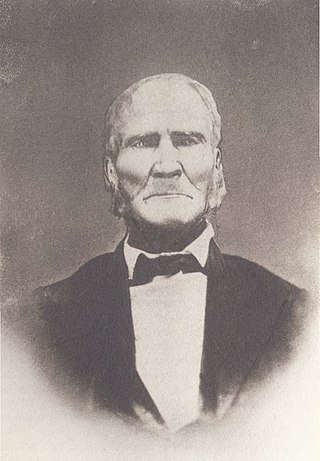
Samuel Whiteside was an Illinois pioneer. A farmer and backwoodsman, Whiteside briefly served in the Illinois General Assembly after statehood and led the Illinois militia for decades, rising to the rank of general but also enlisting as an ordinary soldier when militia calls declined at the end of wars. Whiteside fought the British in the War of 1812 and Native Americans through the Blackhawk War.

The 12th congressional district of Illinois is a congressional district in the southern part of U.S. state of Illinois. It has been represented by Republican Mike Bost since 2015. With a Cook Partisan Voting Index of R+24, it is the most Republican district in Illinois.

Burksville is an unincorporated community in the historic New Design Precinct of Monroe County, Illinois, United States. Originally developed by John P. Brown, Burksville was named in 1857 after John G. Burkhardt, a resident of St. Louis, who opened a store there in 1851. It lies along the old Kaskaskia to St. Louis road off Illinois Route 3, south of Waterloo.

Monroe City is a small unincorporated community in the historic Bluff Precinct of Monroe County, Illinois, United States. As of 2016, the population is approximately 45 people, living in 23 homes. The community is generally considered to comprise the platted towns of Monroe City (1856), Woodville (1857), and the area immediately adjacent to those towns. The core community is located in a valley, or colloquial "hollow," commonly known as the Monroe City Hollow. The central natural feature of the Hollow is the all-season Monroe City Creek. Governmental functions are provided by Monroe County. Electric utilities are provided by the Monroe County Electric Cooperative and public water is offered by the Fountain Water District.

Renault is a small unincorporated community in the historic Renault Precinct of Monroe County, Illinois, United States.

Harrisonville is an unincorporated community in the historic Harrisonville Precinct of Monroe County, Illinois.

St. Joe, Illinois is a small unincorporated community in the historic New Design Precinct of Monroe County, Illinois, United States. It is located along the historic road from Kaskaskia to St. Louis, between Renault and Burksville.

Chaflin Bridge is an unincorporated community in the historic Mitchie Precinct of Monroe County, Illinois, United States. It lies on the old Bluff Road in the American Bottoms between Fults and the old site of Valmeyer and near Maeystown.

<span class="mw-page-title-main">Monroe City Mill</span>

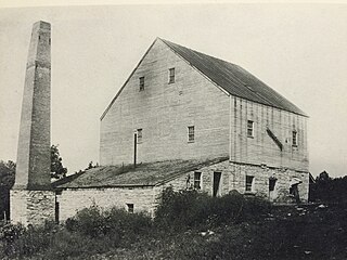
The Monroe City Mill was a grist mill located in Monroe City, Illinois, an unincorporated community in the historic Bluff Precinct of Monroe County, Illinois, United States. Monroe County was founded in 1816. Prior to that, the area was part of St. Clair County in the Illinois Territory.

References

  1. 1 2 "State & County QuickFacts". United States Census Bureau.
  2. "Find a County". National Association of Counties. Retrieved June 7, 2011.
  3. Counties of Illinois, p. 32-33. With Twenty-three Maps Showing the Original and the Present Boundary Lines of Each County of the State, Retrieved on January 22, 2008.
  4. Gannett, Henry (1905). The Origin of Certain Place Names in the United States. U.S. Government Printing Office. p.  212.
  5. Combined History of Randolph, Monroe and Perry Counties, Illinois, J. L. McDonough & Co., Philadelphia, 1883
  6. F. Terry Norris, "Where Did the Villages Go? Steamboats, Deforestation, and Archaeological Loss in the Mississippi Valley", in Common Fields: An Environmental History of St. Louis, Andrew Hurley, ed., St. Louis, MO: Missouri Historical Society Press, 1997, pp. 73-89
  7. " Counties of Illinois pg. 46-47". 1825 Retrieved on January 22, 2008.
  8. " Counties of Illinois, pg. 49-50". 1827 Retrieved on January 22, 2008.
  9. 1 2 "Population, Housing Units, Area, and Density: 2010 - County". United States Census Bureau. Archived from the original on February 13, 2020. Retrieved July 12, 2015.
  10. 1 2 "Monthly Averages for Waterloo, Illinois". The Weather Channel. Retrieved January 27, 2011.
  11. "Annual Estimates of the Resident Population for Counties: April 1, 2020 to July 1, 2023". United States Census Bureau. Retrieved April 2, 2024.
  12. "U.S. Decennial Census". United States Census Bureau. Retrieved July 7, 2014.
  13. "Historical Census Browser". University of Virginia Library. Retrieved July 7, 2014.
  14. "Population of Counties by Decennial Census: 1900 to 1990". United States Census Bureau. Retrieved July 7, 2014.
  15. "Census 2000 PHC-T-4. Ranking Tables for Counties: 1990 and 2000" (PDF). United States Census Bureau. Retrieved July 7, 2014.
  16. "Explore Census Data".
  17. 1 2 3 "DP-1 Profile of General Population and Housing Characteristics: 2010 Demographic Profile Data". United States Census Bureau. Archived from the original on February 13, 2020. Retrieved July 12, 2015.
  18. "DP02 SELECTED SOCIAL CHARACTERISTICS IN THE UNITED STATES – 2006-2010 American Community Survey 5-Year Estimates". United States Census Bureau. Archived from the original on February 13, 2020. Retrieved July 12, 2015.
  19. "DP03 SELECTED ECONOMIC CHARACTERISTICS – 2006-2010 American Community Survey 5-Year Estimates". United States Census Bureau. Archived from the original on February 13, 2020. Retrieved July 12, 2015.
  20. "Directory July 1, 2020-June 30, 2021" (PDF). Illinois Association of Regional Superintendents of Schools. p. 6. Archived from the original (PDF) on December 4, 2020. Retrieved April 24, 2022.
  21. Leip, David. "Dave Leip's Atlas of U.S. Presidential Elections". uselectionatlas.org. Retrieved March 19, 2018.
  22. Illinois State Board of Education, ISBE Education Data Systems, Public School District Lookup, accessed May 26, 2023.

38°17′N90°11′W / 38.28°N 90.18°W / 38.28; -90.18