
U.S. Route 66 or U.S. Highway 66 was one of the original highways in the United States Numbered Highway System. It was established on November 11, 1926, with road signs erected the following year. The highway, which became one of the most famous roads in the United States, originally ran from Chicago, Illinois, through Missouri, Kansas, Oklahoma, Texas, New Mexico, and Arizona before terminating in Santa Monica in Los Angeles County, California, covering a total of 2,448 miles (3,940 km).

Centralia is a city in Clinton, Jefferson, Marion, and Washington counties in the U.S. state of Illinois with the largest portion in Marion County. The city is the largest in three of the counties; Clinton, Marion, and Washington, but is not a county seat of any of them. The population was 12,182 as of the 2020 census, down from 13,032 in 2010.

Collinsville is a city located mainly in Madison County and partially in St. Clair County, Illinois, United States. As of the 2020 census, the city had a population of 24,366. Collinsville is approximately 14 miles (23 km) east of St. Louis, Missouri, and is part of that city's Metro East area.

Edwardsville is a city in and the county seat of Madison County, Illinois, United States. As of the 2020 census, the population was 26,808. The city was named in honor of Ninian Edwards, then Governor of the Illinois Territory.

Belleville is a city and the county seat of St. Clair County, Illinois, coterminous with the now defunct Belleville Township. It is located within Greater St. Louis and is the seventh-largest municipality in the 15-county metropolitan area. It is also the seat of the Roman Catholic Diocese of Belleville and the National Shrine of Our Lady of the Snows. The population was 44,478 according to the Census Bureau's 2010 data, making it the largest city in the state south of Springfield.
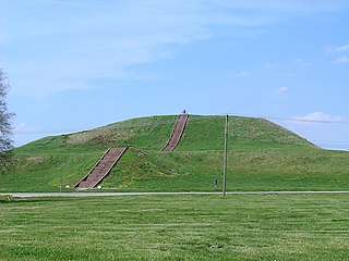
The Cahokia Mounds State Historic Site is the site of a pre-Columbian Native American city directly across the Mississippi River from modern St. Louis, Missouri. This historic park lies in south-western Illinois between East St. Louis and Collinsville. The park covers 2,200 acres (890 ha), or about 3.5 square miles (9 km2), and contains about 80 manmade mounds, but the ancient city was much larger. At its apex around 1100 CE, the city covered about 6 square miles (16 km2) and included about 120 earthworks in a wide range of sizes, shapes, and functions.

The Eads Bridge is a combined road and railway bridge over the Mississippi River connecting the cities of St. Louis, Missouri and East St. Louis, Illinois. It is located on the St. Louis riverfront between Laclede's Landing, to the north, and the grounds of the Gateway Arch, to the south. The bridge is named for its designer and builder, James Buchanan Eads. Work on the bridge began in 1867, and it was completed in 1874. The Eads Bridge was the first bridge across the Mississippi south of the Missouri River. Earlier bridges were located north of the Missouri, where the Mississippi is smaller. None of the earlier bridges survive, which means that the Eads Bridge is also the oldest bridge on the river.

Starved Rock State Park is a state park in the U.S. state of Illinois, characterized by the many canyons within its 2,630 acres (1,064 ha). Located just southeast of the village of Utica, in Deer Park Township, LaSalle County, Illinois, along the south bank of the Illinois River, the park hosts over two million visitors annually, the most for any Illinois state park.

Prairie School is a late 19th- and early 20th-century architectural style, most common in the Midwestern United States. The style is usually marked by horizontal lines, flat or hipped roofs with broad overhanging eaves, windows grouped in horizontal bands, integration with the landscape, solid construction, craftsmanship, and discipline in the use of ornament. Horizontal lines were thought to evoke and relate to the wide, flat, treeless expanses of America's native prairie landscape.

The Lewis and Clark National Historic Trail is a route across the United States commemorating the Lewis and Clark Expedition of 1804 to 1806. It is part of the National Trails System of the United States. It extends for some 4,900 miles (7,900 km) from Pittsburgh, Pennsylvania, to the mouth of the Columbia River in Oregon.

Metro East is a region in southern Illinois that contains eastern and northern suburbs and exurbs of St. Louis, Missouri, United States. It encompasses five Southern Illinois counties in the St. Louis Metropolitan Statistical Area. The region's most populated city is Belleville, with 45,000 residents. The Metro East is the second largest urban area in Illinois after the Chicago metropolitan area and, as of the 2000 census, the population of the Metro East statistical area was 599,845 residents, a figure that had risen to above 700,000 in 2010. The significant growth in the Metro East is mainly due to people in smaller outlying towns in Illinois moving to the area for better economic/job opportunities.

The National Register of Historic Places in the United States is a register including buildings, sites, structures, districts, and objects. The Register automatically includes all National Historic Landmarks as well as all historic areas administered by the U.S. National Park Service. Since its introduction in 1966, more than 90,000 separate listings have been added to the register.

This is a list of properties and districts in Illinois that are on the National Register of Historic Places. There are over 1,900 in total. Of these, 85 are National Historic Landmarks. There are listings in all of the state's 102 counties.
This National Park Service list is complete through NPS recent listings posted March 17, 2023.
The Illinois Historic Preservation Division, formerly Illinois Historic Preservation Agency, is a governmental agency of the U.S. state of Illinois, and is a division of the Illinois Department of Natural Resources. It is tasked with the duty of maintaining State-owned historic sites, and maximizing their educational and recreational value to visitors or on-line users. In addition, it manages the process for applications within the state for additions to the National Register of Historic Places.
U.S. Route 66 was a United States Numbered Highway in Illinois that connected St. Louis, Missouri, and Chicago, Illinois. The historic Route 66, the Mother Road or Main Street of America, took long distance automobile travelers from Chicago to Southern California. The highway had previously been Illinois Route 4 and the road has now been largely replaced with Interstate 55 (I-55). Parts of the road still carry traffic and six separate portions of the roadbed have been listed on the National Register of Historic Places.
This is an incomplete list of historic properties and districts at United States colleges and universities that are listed on the National Register of Historic Places (NRHP). This includes National Historic Landmarks (NHLs) and other National Register of Historic Places listings. It includes listings at current and former educational institutions.

St. Charles is a city in DuPage and Kane counties in the U.S. state of Illinois. It lies roughly 40 miles (64 km) west of Chicago on Illinois Route 64. Per the 2020 census, the population was 33,081. The official city slogan is "Pride of the Fox", after the Fox River that runs through the center of town. St. Charles is part of a tri-city area along with Geneva and Batavia, all western suburbs of similar size and socioeconomic condition.

The following outline is provided as an overview of and topical guide to the U.S. state of Illinois:

St. James Catholic Church and Cemetery, also known as St. James at Sag Bridge Church is a historic church and cemetery in the Sag Bridge area of the village of Lemont, Illinois. It is situated on a high bluff at the western tip of the glacier-carved Mount Forest Island, overlooking the Calumet Sag Channel and the community of Sag Bridge.
Sag Bridge, Illinois is an Unincorporated community in Lemont Township in southwestern Cook County, Illinois, United States. Sag Bridge is an important waterway junction between the Calumet Sag Channel and the Chicago Sanitary and Ship Canal. It is also the junction of IL 83 and IL 171 which meet at Sag Bridge to cross the Calumet Sag Channel together on the eponymous bridge. The community was named for a predecessor of the present bridge. It is within the village limits and postal delivery zone of Lemont, Illinois.


