
Monroe County is a county located in the U.S. state of Illinois. According to the 2020 census, it had a population of 34,962. Its county seat and largest city is Waterloo.

Hardin County is a county located in the U.S. state of Illinois. According to the 2020 census, it has a population of 3,649, making it the least populous county in Illinois. Its county seat is Elizabethtown. Hardin County is located in the part of the state known as Little Egypt. Hardin County was named for Hardin County, Kentucky, which was named in honor of Colonel John Hardin, an officer in the American Revolutionary War and the Northwest Indian War.

Calhoun County is a county in the U.S. state of Illinois. As of the 2020 census, the population was 4,437, making it Illinois’ third-least populous county. Its county seat and biggest community is Hardin, with a population of 801. Its smallest incorporated community is Hamburg, with a population of 99. Calhoun County is at the tip of the peninsula formed by the courses of the Mississippi and Illinois rivers above their confluence and is almost completely surrounded by water. Calhoun County is sparsely populated; it has just five municipalities, all of them villages.
Fults is a village in the Renault precinct of Monroe County, Illinois, United States. The population was 28 at the 2020 census. It is located entirely within the American Bottom floodplain of the Mississippi River.

Valmeyer is a village in Monroe County, Illinois, United States. The population was 1,233 at the 2020 census. It was originally located in the American Bottom floodplain of the Mississippi River but now occupies higher land to the east.

Kaskaskia is a village in Randolph County, Illinois. Having been inhabited by indigenous peoples, it was settled by France as part of the Illinois Country. It was named for the Kaskaskia people. Its population peaked at about 7,000 in the 18th century, when it was a regional center. During the American Revolutionary War, the town, which by then had become an administrative center for the British Province of Quebec, was taken by the Virginia militia during the Illinois campaign. It was designated as the county seat of Illinois County, Virginia, after which it became part of the Northwest Territory in 1787. Kaskaskia was later named as the capital of the United States' Illinois Territory, created on February 3, 1809. In 1818, when Illinois became the 21st U.S. state, the town briefly served as the state's first capital until 1819, when the capital was moved to more centrally located Vandalia.

The American Bottom is the flood plain of the Mississippi River in the Metro-East region of Southern Illinois, extending from Alton, Illinois, south to the Kaskaskia River. It is also sometimes called "American Bottoms". The area is about 175 square miles (450 km2), mostly protected from flooding in the 21st century by a levee and drainage canal system. Immediately across the river from St. Louis, Missouri, are industrial and urban areas, but nearby marshland, swamps, and the Horseshoe Lake are reminders of the Bottoms' riparian nature.
The Mitchigamea or Michigamea or Michigamie were a tribe in the Illinois Confederation. Not much is known about them and their origin is uncertain. Originally they were said to be from Lake Michigan, perhaps the Chicago area. Mitchie Precinct, Monroe County in Southwestern Illinois takes its name from their transient presence nearby, north of the French Fort de Chartres in the American Bottom along the Mississippi. One of their villages in the American Bottom, inhabited from 1730 until 1752, is one of the region's premier archaeological sites; it is known as the "Kolmer Site".
Monroe City is a small unincorporated community in the historic Bluff Precinct of Monroe County, Illinois, United States. As of 2016, the population is approximately 45 people, living in 23 homes. The community is generally considered to comprise the platted towns of Monroe City (1856), Woodville (1857), and the area immediately adjacent to those towns. The core community is located in a valley, or colloquial "hollow," commonly known as the Monroe City Hollow. The central natural feature of the Hollow is the all-season Monroe City Creek. Governmental functions are provided by Monroe County. Electric utilities are provided by the Monroe County Electric Cooperative and public water is offered by the Fountain Water District.
Renault is a small unincorporated community in the historic Renault Precinct of Monroe County, Illinois, United States.
Fountain is an unincorporated community in the historic Moredock Precinct of Monroe County, Illinois, United States, located just off Bluff Road in the American Bottoms, situated next to the levees lining Fountain Creek as it makes its way west toward the Mississippi River.
Foster Pond is an unincorporated community in the historic Bluff Precinct of Monroe County, Illinois, United States. It is located along the historic road, the present Illinois Route 156 which ran from the landings on the Mississippi River at the old county seat of Harrisonville to Waterloo and beyond.
Chaflin Bridge is an unincorporated community in the historic Mitchie Precinct of Monroe County, Illinois, United States. It lies on the old Bluff Road in the American Bottoms between Fults and the old site of Valmeyer and near Maeystown.
Merrimac, Illinois is a small unincorporated community in the historic Moredock Precinct of Monroe County, Illinois, United States. It is located in the American Bottoms, adjacent to the Mississippi River levee due south of that river's confluence with the Meramec. It takes its name from this river whose name was translated as 'Ugly Water' from Algonquian by French Jesuits in the area. However scholars of the language translate it as 'place of strong current', which would certainly seem consistent.

Kaskaskia Precinct is located in Randolph County, Illinois, USA. As of the 2010 census, its population was 47. This precinct is separated from the rest of Randolph County by the Mississippi River.

Dozaville is an unincorporated community in Randolph County, Illinois, United States. Dozaville is located in Kaskaskia Precinct, which is west of the Mississippi River.
Harrisonville may refer to:
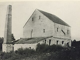
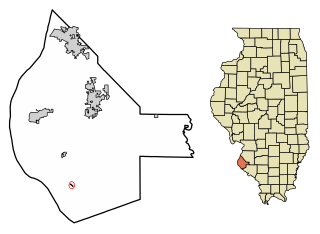
The Monroe City Mill was a grist mill located in Monroe City, Illinois, an unincorporated community in the historic Bluff Precinct of Monroe County, Illinois, United States. Monroe County was founded in 1816. Prior to that, the area was part of St. Clair County in the Illinois Territory.


