Kane County, Illinois

Last updated

Kane County
County
Fabyan Windmill-13.JPG
Flag of Kane County, Illinois.png
Seal of Kane County.jpg
Map of Illinois highlighting Kane County.svg
Location within the U.S. state of Illinois
Illinois in United States.svg
Illinois's location within the U.S.
Coordinates: 41°57′N88°26′W / 41.95°N 88.43°W / 41.95; -88.43
CountryFlag of the United States.svg United States
StateFlag of Illinois.svg  Illinois
FoundedJanuary 16, 1836
Named for Elias Kane
Seat Geneva
Largest city Aurora
Area
  Total524 sq mi (1,360 km2)
  Land520 sq mi (1,300 km2)
  Water4.1 sq mi (11 km2)  0.8%
Population
 (2020)
  Total516,522 Increase2.svg
  Density990/sq mi (380/km2)
Time zone UTC−6 (Central)
  Summer (DST) UTC−5 (CDT)
Congressional districts 8th, 11th, 14th
Website countyofkane.org
[1]

Kane County is a county in the U.S. state of Illinois. According to the 2020 census, it has a population of 516,522, [2] making it the fifth-most populous county in Illinois. Its county seat is Geneva, [3] and its largest city is Aurora. Kane County is one of the collar counties of the metropolitan statistical area designated "ChicagoNapervilleElgin, IL–INWI" by the US census.

Contents

History

Kane County was formed out of LaSalle County in 1836. The county was named in honor of Elias Kane, a United States senator and the first secretary of state of Illinois. [4]

Geography

According to the U.S. Census Bureau, the county's area was 524 square miles (1,360 km2), of which 520 square miles (1,300 km2) is land and 4.1 square miles (11 km2) (0.8%) is water. [5] Its largest cities are along the Fox River.

Climate

Geneva, Illinois
Climate chart (explanation)
J
F
M
A
M
J
J
A
S
O
N
D
 
 
1.6
 
 
29
10
 
 
1.5
 
 
35
16
 
 
2.6
 
 
46
26
 
 
3.9
 
 
59
36
 
 
3.9
 
 
71
46
 
 
4.3
 
 
81
56
 
 
4.4
 
 
84
61
 
 
4.4
 
 
82
58
 
 
3.5
 
 
75
50
 
 
2.7
 
 
63
38
 
 
3.2
 
 
47
28
 
 
2.4
 
 
34
16
Average max. and min. temperatures in °F
Precipitation totals in inches
Source: The Weather Channel [6]
Metric conversion
J
F
M
A
M
J
J
A
S
O
N
D
 
 
41
 
 
−2
−12
 
 
39
 
 
2
−9
 
 
65
 
 
8
−3
 
 
99
 
 
15
2
 
 
99
 
 
22
8
 
 
110
 
 
27
13
 
 
112
 
 
29
16
 
 
111
 
 
28
14
 
 
89
 
 
24
10
 
 
69
 
 
17
3
 
 
81
 
 
8
−2
 
 
61
 
 
1
−9
Average max. and min. temperatures in °C
Precipitation totals in mm

In recent years, average temperatures in the county seat of Geneva have ranged from a low of 10 °F (−12 °C) in January to a high of 84 °F (29 °C) in July, although a record low of −26 °F (−32 °C) was recorded in January 1985 and a record high of 111 °F (44 °C) was recorded in July 1936. The average monthly precipitation ranged from 1.52 inches (39 mm) in February to 4.39 inches (112 mm) in July. [6]

Adjacent counties

Parks and recreation

Forest preserves

Kane County has an extensive forest preserve program, with numerous nature preserves, historic sites, and trails. [7]

Demographics

Historical population
CensusPop.Note
1840 6,501
1850 16,703156.9%
1860 30,06280.0%
1870 39,09130.0%
1880 44,93915.0%
1890 65,06144.8%
1900 78,79221.1%
1910 91,86216.6%
1920 99,4998.3%
1930 125,32726.0%
1940 130,2063.9%
1950 150,38815.5%
1960 208,24638.5%
1970 251,00520.5%
1980 278,40510.9%
1990 317,47114.0%
2000 404,11927.3%
2010 515,26927.5%
2020 516,5220.2%
2023 (est.)514,982 [8] −0.3%
U.S. Decennial Census [9]
1790–1960 [10] 1900–1990 [11]
1990–2000 [12] 2010–2019 [2]
2000 census age pyramid for Kane County USA Kane County, Illinois age pyramid.svg
2000 census age pyramid for Kane County

As of the 2010 census, there were 515,269 people, 170,479 households, and 128,323 families residing in the county. [13] The population density was 990.8 inhabitants per square mile (382.6/km2). There were 182,047 housing units at an average density of 350.1 per square mile (135.2/km2). [5] The racial makeup of the county was 74.6% white, 5.7% black or African American, 3.5% Asian, 0.6% American Indian, 13.0% from other races, and 2.6% from two or more races. Those of Hispanic or Latino origin made up 30.7% of the population. In terms of ancestry, 24.3% were German, 13.0% were Irish, 7.9% were Polish, 7.4% were Italian, 7.1% were English, and 2.4% were American.

Of the 170,479 households, 42.3% had children under the age of 18 living with them, 59.2% were married couples living together, 11.0% had a female householder with no husband present, 24.7% were non-families, and 19.8% of all households were made up of individuals. The average household size was 2.98 and the average family size was 3.45. The median age was 34.5 years. [13]

The median income for a household in the county was $67,767 and the median income for a family was $77,998. Males had a median income of $53,833 versus $39,206 for females. The per capita income for the county was $29,480. About 7.0% of families and 9.1% of the population were below the poverty line, including 13.5% of those under age 18 and 5.7% of those age 65 or over. [14]

Education

Infrastructure

Health care

There are several hospitals serving the county:

Transportation

Transit

Airport

Major highways

Kane county has an extensive county highway system that includes federal, state and county maintained routes. During the years that the county was represented by Dennis Hastert it received many federal earmarks for highway improvements to respond to population growth. In addition, the county has entered into an agreement with the Illinois State Toll Highway Authority to operate a limited access toll bridge on the Longmeadow Parkway that is not connected to any other tollway.

Communities

Cities

Villages

Census-designated place

Other unincorporated communities

Townships

Government

Kane County Board

Kane County services are overseen by a 24 member Board which is elected every two years. The Board's chair is elected every four years. The Board sets the County's budget. Corrine Michelle Pierog is the current County Board Chair. There are currently 16 Democrats and 8 Republicans on the Board.

In addition to the Board chair, there are nine county officeholders elected countywide every four years. These positions are the Auditor, Circuit Clerk, County Clerk, Coroner, Recorder, Regional Office of Education Superintendent, Sheriff, State's Attorney, and Treasurer.

Current elected officials

Kane County Board Members, 2022-2024 [15]
PartyDistrictBoard MemberCity/town
ChairCorinne PierogBatavia
1Myrna MolinaAurora
2Dale BermanNorth Aurora
3Anita LewisAurora
4Mavis BatesAurora
5Bill LenertSugar Grove
6Ron FordAurora
7Monica SilvaAurora
8Michelle GumzAurora
9Gary DaughteryGilberts
10Bill TarverBatavia
11Leslie JubyGeneva
12Bill RothSt. Charles
13Michael LinderSt. Charles
14Mark DavoustSt. Charles
15David YoungElgin
16Michael KenyonSouth Elgin
17Deborah AllanElgin
18Rick WilliamsGeneva
19Mohammad "Mo" IqbalElgin
20Cherryl Fritz StrathmannElgin
21Clifford SurgesGilberts
22Verner (Vern) TepeElgin
23Chris KiousAlgonquin
24Jarett SanchezCarpentersville
Countywide Officeholders, 2022-2024 [16] [17]
PartyOfficeNamePartyServing Until
Kane County ClerkJohn "Jack" A. CunninghamRepublican2026
SheriffRon HainDemocratic2026
Treasurer Chris Lauzen Republican2026
Board ChairCorinne M. PierogDemocratic2024
Circuit ClerkTheresa BarreiroDemocratic2024
AuditorPenny WegmanDemocratic2024
CoronerL. Robert RussellRepublican2024
RecorderSandy WegmanRepublican2024
State's AttorneyJamie MosserDemocratic2024

16th Circuit

Kane County is coterminous with the 16th Judicial Circuit. The 16th Judicial Circuit is divided into four subcircuits. The first subcircuit consists of the majority of Aurora Township. The second subcircuit consists of most of Elgin and Dundee townships. The fourth subcircuit consists the tri-cities area of Batavia, Geneva, and Saint Charles. The third subcircuit consists of all territory not included in the other three subcircuits, which corresponds to an area of roughly the western two thirds of the county. [18]

Politics

As one of the Yankee-settled and prosperous suburban "collar counties", Kane County was a stronghold of the Free Soil Party in its first few elections, being one of nine Illinois counties to give a plurality to Martin van Buren in 1848. Kane County then unsurprisingly became solidly Republican for the century and a half following that party's formation. It voted for the GOP presidential nominee in every election between 1856 and 2004 except that of 1912 when the Republican Party was mortally divided and Progressive candidate Theodore Roosevelt carried the county with a majority of the vote over conservative incumbent William Howard Taft.

The gradual shift of the GOP towards white Southern Evangelicals, however, has led the generally moderate electorate of Kane and the other "collar counties" to trend towards the Democratic Party. In 2008, Senator Barack Obama became the first Democrat to carry Kane County since Franklin Pierce in 1852, and the first ever to win an absolute majority of the county's vote (the previous two Democratic winners, Pierce and James K. Polk in 1844 had both gained only pluralities due to strong Free Soil votes). Obama won a plurality in 2012, and Hillary Clinton improved upon Obama's showing to become the second Democrat to win a majority in 2016. In 2020, Joe Biden had the best performance ever by a Democrat in the county, even besting Obama's 2008 victory.

Kane County is represented in the United States House of Representatives by Democrats Bill Foster (11th District), Raja Krishnamoorthi (8th District), and Lauren Underwood (14th District). [19]

United States presidential election results for Kane County, Illinois [20]
Year Republican Democratic Third party
No.%No.%No.%
2020 96,77541.74%130,16656.14%4,9352.13%
2016 82,73441.43%103,66551.91%13,2886.65%
2012 88,33548.61%90,33249.71%3,0581.68%
2008 83,96343.42%106,75655.21%2,6441.37%
2004 92,06555.03%73,81344.12%1,4190.85%
2000 76,99654.45%60,12742.52%4,2823.03%
1996 54,37547.41%47,90241.77%12,41610.83%
1992 55,68443.52%44,56834.84%27,68621.64%
1988 66,28364.10%36,36635.17%7630.74%
1984 72,65569.09%31,87530.31%6290.60%
1980 64,10661.77%29,01527.96%10,66310.27%
1976 59,27562.15%34,05735.71%2,0422.14%
1972 64,54669.87%27,52529.80%3060.33%
1968 54,14461.94%26,60930.44%6,6677.63%
1964 46,39153.27%40,70346.73%00.00%
1960 55,38963.84%31,27936.05%930.11%
1956 56,00972.82%20,84827.10%590.08%
1952 50,80167.78%24,05832.10%960.13%
1948 39,28464.41%21,17634.72%5320.87%
1944 38,68962.16%23,36237.54%1850.30%
1940 41,94961.77%25,67637.81%2890.43%
1936 33,49152.55%28,18744.23%2,0513.22%
1932 32,93456.15%24,63842.00%1,0841.85%
1928 38,23669.94%16,18429.60%2530.46%
1924 32,71776.34%3,5178.21%6,62415.46%
1920 26,83282.82%4,32313.34%1,2433.84%
1916 23,86867.71%9,87528.01%1,5064.27%
1912 2,41512.67%4,39423.05%12,25764.29%
1908 12,84070.29%4,31623.63%1,1116.08%
1904 12,63875.64%2,79916.75%1,2717.61%
1900 12,03167.55%5,25929.53%5212.93%
1896 12,13369.94%4,85227.97%3622.09%
1892 7,97753.80%5,77838.97%1,0727.23%

See also

Notable people

Related Research Articles

<span class="mw-page-title-main">McHenry County, Illinois</span> County in Illinois, United States

McHenry County is a county located in the U.S. state of Illinois. According to the 2020 Census, it had a population of 310,229, making it the sixth-most populous county in Illinois. Its county seat is Woodstock. McHenry County is one of the five Illinois collar counties in the Chicago-Naperville-Elgin, IL-IN-WI Metropolitan Statistical Area. Long known as a center of recreation along with agriculture in the western portion, it has more recently experienced rapid rates of suburbanization, exurbanization and urbanization, but the western portions of the county remain primarily agricultural and rural.

<span class="mw-page-title-main">DuPage County, Illinois</span> County in Illinois, United States

DuPage County is a county in the U.S. state of Illinois, and one of the collar counties of the Chicago metropolitan area. As of the 2020 census, the population was 932,877, making it Illinois' second-most populous county. Its county seat is Wheaton.

<span class="mw-page-title-main">Elgin, Illinois</span> City in Illinois, United States

Elgin is a city in Cook and Kane counties in the U.S. state of Illinois. It is located 35 mi (56 km) northwest of Chicago along the Fox River. As of the 2020 census, the city had a population of 114,797, making it the sixth-most populous city in the state.

<span class="mw-page-title-main">Aurora, Illinois</span> City in Illinois, United States

Aurora is a city in northeastern Illinois, United States. Located primarily in DuPage and Kane counties along the Fox River, it is the second-most populous city in Illinois, after Chicago, and the 144th-most populous city in the U.S. The population was 180,542 at the 2020 census.

<span class="mw-page-title-main">Batavia, Illinois</span> City in Illinois, United States

Batavia is a city mainly in Kane County and partly in DuPage County in the U.S. state of Illinois. Located in the Chicago metropolitan area, it was founded in 1833 and is the oldest city in Kane County. Per the 2020 census, the population was 26,098.

<span class="mw-page-title-main">Wayne, Illinois</span> Village in Illinois, United States

Wayne is a village in DuPage and Kane counties, Illinois, United States. The eastern portion, in DuPage County, is in Wayne Township, while the western portion, in Kane County, is in St. Charles Township. The population was 2,286 as of the 2020 census.

<span class="mw-page-title-main">Carpentersville, Illinois</span> Village in Illinois, United States

Carpentersville is a village in Kane County, Illinois, United States. The population was 37,983 at the 2020 census. It is part of the Chicago metropolitan area.

<span class="mw-page-title-main">Elburn, Illinois</span> Village in Illinois, United States

Elburn is a village in Kane County, Illinois, United States. The population was 5,602 as of the 2010 census, up from 2,756 at the 2000 census. It is located at the intersection of Illinois Route 38 and Route 47. Elburn is a town situated 46 miles (74 km) west of the Chicago Loop with frequent commuter rail service from its Metra station at the end of the Union Pacific West Line.

<span class="mw-page-title-main">Illinois Route 31</span> State highway in northeastern Illinois, US

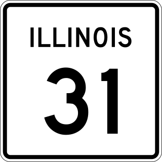
Illinois Route 31 (IL 31) is a 58.41-mile-long (94.00 km) north–south state highway in northeastern Illinois, United States. It travels from U.S. Route 34 (US 34) in Oswego north to US 12, near the Wisconsin state line, just south of Richmond.

<span class="mw-page-title-main">Area codes 630 and 331</span> Telephone area codes for the western suburbs of Chicago, Illinois

Area codes 630 and 331 are telephone area codes in the North American Numbering Plan (NANP) for portions of Chicago's near and far western suburbs, including the majority of DuPage County, Illinois. To the northwest, the numbering plan area (NPA) also includes a small portion of Cook County, including parts of Schaumburg, Streamwood and Hanover Park. To the west, Kane County is divided between area codes 847 and 224 in the north, including Elgin, and area codes 630 and 331 in the south, including Aurora. To the south, the northern part of Will County and a small part of southern Cook County, including the village of Burr Ridge and parts of the village of Lemont, are also included in the 630 and 331 area codes. To the southwest, the city of Yorkville, in exurban Kendall County, is included, as well.

<span class="mw-page-title-main">Fox Valley (Illinois)</span> Region centered on the Fox River of Northern Illinois

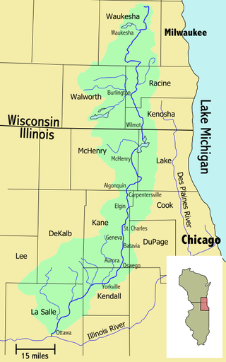
The Fox Valley—also commonly known as the Fox River Valley—is a region centered on the Fox River of Northern Illinois, along the western edges of the Chicago metropolitan area. The region extends from the village of Antioch, in far northern Illinois, to the city of Ottawa in the south. It includes rural areas, suburban development, and 19th-century downtowns. Around 1 million people live in this area.

<span class="mw-page-title-main">Illinois Prairie Path</span> Bicycle trail network in Illinois, US

The Illinois Prairie Path is a network of 61 miles (98 km) of bicycle trails, mostly in DuPage County, Illinois. Portions of the trail extend west to Kane County and east to Cook County. Most of the trail is categorized as rail-to-trail, meaning that the bicycle path is built atop a converted former railroad right of way. In the case of the Prairie Path, the vast majority of its routing runs on the former right-of-way of the Chicago Aurora and Elgin Railroad.

<span class="mw-page-title-main">Illinois's 8th congressional district</span> U.S. House district for Illinois

The 8th congressional district of Illinois is a congressional district in the U.S. state of Illinois that has been represented by Democrat Raja Krishnamoorthi since 2017.

<span class="mw-page-title-main">Geneva, Illinois</span> City in Illinois, United States

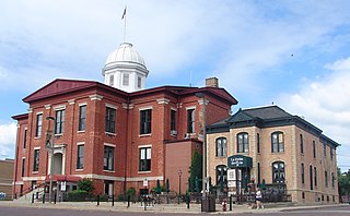
Geneva is a city in and the county seat of Kane County, Illinois, United States. It is located on the western side of the Chicago suburbs. Per the 2020 census, the population was 21,393.

<span class="mw-page-title-main">Illinois's 11th congressional district</span> U.S. House district for Illinois

The 11th congressional district of Illinois is represented by Democrat Bill Foster.

<span class="mw-page-title-main">Batavia Township, Kane County, Illinois</span> Township in Illinois, United States

Batavia Township is in Kane County, Illinois. It is divided by the Fox River. As of the 2010 census, its population was 35,221 and it contained 12,892 housing units. The western part of the United States Department of Energy's Fermilab is at the township's eastern edge, although most of the facility is in neighboring Winfield Township in DuPage County.

<span class="mw-page-title-main">Campton Township, Kane County, Illinois</span> Township in Illinois, United States

Campton Township is located in Kane County, Illinois. As of the 2010 census, its population was 17,174 and it contained 5,662 housing units.

<span class="mw-page-title-main">Winfield Township, DuPage County, Illinois</span> Township in Illinois, United States

Winfield Township is one of nine townships in DuPage County, Illinois, USA. As of the 2020 census, its population was 45,836 and it contained 16,445 housing units. It is the least populous of the DuPage County Townships.

<span class="mw-page-title-main">Fox River Trail (Illinois)</span> Long-distance hiking trail in the United States

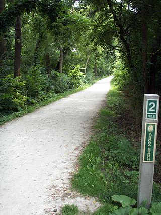
The Fox River Trail is a multi-use path in Illinois along the Fox River. Largely in Kane County, the trail connects the communities of Algonquin, Carpentersville, Dundee, Elgin, South Elgin, St. Charles, Geneva, Batavia, North Aurora, Aurora, Montgomery, and Oswego.

<span class="mw-page-title-main">Tri-Cities, Illinois</span> Region in Illinois

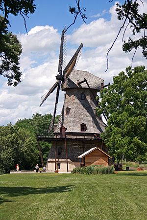
The Tri-Cities, or Tri-City area, is a vernacular region that is situated between the large cities of Aurora and Elgin, Illinois, and encompasses the cities of Batavia, Geneva, and St. Charles.

References

  1. "Kane County". Geographic Names Information System . United States Geological Survey, United States Department of the Interior.
  2. 1 2 "State & County QuickFacts". United States Census Bureau. Archived from the original on June 6, 2011. Retrieved July 6, 2021.
  3. "Find a County". National Association of Counties. Archived from the original on May 31, 2011. Retrieved June 7, 2021.
  4. Gannett, Henry (1905). The Origin of Certain Place Names in the United States. Govt. Print. Off. pp.  172 . Retrieved October 18, 2015.
  5. 1 2 "Population, Housing Units, Area, and Density: 2010 – County". United States Census Bureau. Archived from the original on February 12, 2020. Retrieved July 12, 2015.
  6. 1 2 "Monthly Averages for Geneva, Illinois". The Weather Channel. Archived from the original on October 23, 2012. Retrieved January 27, 2011.
  7. "Forest Preserves". Forest Preserve District of Kane County. Archived from the original on December 15, 2018. Retrieved December 13, 2018.
  8. "Annual Estimates of the Resident Population for Counties: April 1, 2020 to July 1, 2023". United States Census Bureau. Retrieved April 2, 2024.
  9. "U.S. Decennial Census". United States Census Bureau. Retrieved April 16, 2015.
  10. "Historical Census Browser". University of Virginia Library. Archived from the original on August 11, 2012. Retrieved July 6, 2014.
  11. "Population of Counties by Decennial Census: 1900 to 1990". United States Census Bureau. Archived from the original on April 24, 2014. Retrieved July 6, 2014.
  12. "Census 2000 PHC-T-4. Ranking Tables for Counties: 1990 and 2000" (PDF). United States Census Bureau. Archived (PDF) from the original on December 18, 2014. Retrieved July 6, 2014.
  13. 1 2 "DP-1 Profile of General Population and Housing Characteristics: 2010 Demographic Profile Data". United States Census Bureau. Archived from the original on February 13, 2020. Retrieved July 12, 2015.
  14. "DP03 SELECTED ECONOMIC CHARACTERISTICS – 2006–2010 American Community Survey 5-Year Estimates". United States Census Bureau. Archived from the original on February 13, 2020. Retrieved July 12, 2015.
  15. "Pages - Board Members". www.countyofkane.org. Retrieved December 3, 2023.
  16. "2020 General Election Contest Results - Kane County Elections". electionresults.kanecountyil.gov. Retrieved December 3, 2023.
  17. "2022 General Election Contest Results - Kane County Elections". electionresults.kanecountyil.gov. Retrieved December 3, 2023.
  18. Kane County Clerk (April 22, 2022). "Judicial Subcircuts Created by P.A. 97-0585" . Retrieved April 22, 2022.
  19. "2022 Cook PVI: District Map and List". Cook Political Report. July 12, 2022. Retrieved December 3, 2023.
  20. Leip, David. "Dave Leip's Atlas of U.S. Presidential Elections". uselectionatlas.org. Archived from the original on March 23, 2018. Retrieved July 5, 2017.
General

41°57′N88°26′W / 41.950°N 88.433°W / 41.950; -88.433