Menard County, Illinois

Last updated

Menard County
Menard County Courthouse, IL (4504031312).jpg
Menard County Courthouse, Petersburg, Illinois
Map of Illinois highlighting Menard County.svg
Location within the U.S. state of Illinois
Illinois in United States.svg
Illinois's location within the U.S.
Coordinates: 40°02′N89°48′W / 40.03°N 89.8°W / 40.03; -89.8
CountryFlag of the United States.svg United States
StateFlag of Illinois.svg  Illinois
Founded1839
Named for Pierre Menard
Seat Petersburg
Largest cityPetersburg
Area
  Total315 sq mi (820 km2)
  Land314 sq mi (810 km2)
  Water1.0 sq mi (3 km2)  0.3%
Population
 (2020)
  Total12,297
  Density39/sq mi (15/km2)
Time zone UTC−6 (Central)
  Summer (DST) UTC−5 (CDT)
Congressional district 15th
Website www.menardcountyil.com

Menard County is a county in the U.S. state of Illinois. According to the 2020 United States Census, it had a population of 12,297. [1] Its county seat is Petersburg. Menard County is part of the Springfield, Illinois, IL Metropolitan Statistical Area.

Contents

History

Menard County was formed in 1839 out of Sangamon County. The County was named for Pierre Menard, the first lieutenant governor of Illinois. [2]

Geography

According to the US Census Bureau, the county has an area of 315 square miles (820 km2), of which 314 square miles (810 km2) is land and 1.0 square mile (2.6 km2) (0.3%) is water. [3]

Climate and weather

Petersburg, Illinois
Climate chart (explanation)
J
F
M
A
M
J
J
A
S
O
N
D
 
 
1.6
 
 
33
17
 
 
1.8
 
 
39
22
 
 
3.2
 
 
51
32
 
 
3.4
 
 
63
42
 
 
4.1
 
 
74
53
 
 
3.8
 
 
83
62
 
 
3.5
 
 
87
66
 
 
3.4
 
 
85
64
 
 
2.8
 
 
79
55
 
 
2.6
 
 
67
44
 
 
2.9
 
 
51
34
 
 
2.5
 
 
38
23
Average max. and min. temperatures in °F
Precipitation totals in inches
Source: The Weather Channel [4]
Metric conversion
J
F
M
A
M
J
J
A
S
O
N
D
 
 
41
 
 
1
−8
 
 
46
 
 
4
−6
 
 
80
 
 
11
0
 
 
85
 
 
17
6
 
 
103
 
 
23
12
 
 
96
 
 
28
17
 
 
90
 
 
31
19
 
 
87
 
 
29
18
 
 
72
 
 
26
13
 
 
67
 
 
19
7
 
 
73
 
 
11
1
 
 
65
 
 
3
−5
Average max. and min. temperatures in °C
Precipitation totals in mm

In recent years, average temperatures in the county seat of Petersburg have ranged from a low of 17 °F (−8 °C) in January to a high of 87 °F (31 °C) in July, although a record low of −24 °F (−31 °C) was recorded in February 1905 and a record high of 112 °F (44 °C) was recorded in July 1954. Average monthly precipitation ranged from 1.62 inches (41 mm) in January to 4.06 inches (103 mm) in May. [4]

Major highways

Adjacent counties

Demographics

Historical population
CensusPop.Note
1840 4,431
1850 6,34943.3%
1860 9,58451.0%
1870 11,73522.4%
1880 13,02411.0%
1890 13,1200.7%
1900 14,3369.3%
1910 12,796−10.7%
1920 11,694−8.6%
1930 10,575−9.6%
1940 10,6630.8%
1950 9,639−9.6%
1960 9,248−4.1%
1970 9,6854.7%
1980 11,70020.8%
1990 11,164−4.6%
2000 12,48611.8%
2010 12,7051.8%
2020 12,297−3.2%
2023 (est.)11,954 [5] −2.8%
US Decennial Census [6]
1790-1960 [7] 1900-1990 [8]
1990-2000 [9] 2010 [10]

As of the 2010 United States Census, there were 12,705 people, 5,140 households, and 3,683 families living in the county. [11] The population density was 40.4 inhabitants per square mile (15.6/km2). There were 5,654 housing units at an average density of 18.0 per square mile (6.9/km2). [3] The racial makeup of the county was 97.5% white, 0.6% black or African American, 0.3% American Indian, 0.2% Asian, 0.4% from other races, and 1.1% from two or more races. Those of Hispanic or Latino origin made up 1.0% of the population. [11] In terms of ancestry, 32.5% were German, 20.8% were American, 15.6% were Irish, and 14.3% were English. [12]

Of the 5,140 households, 32.4% had children under the age of 18 living with them, 57.5% were married couples living together, 9.6% had a female householder with no husband present, 28.3% were non-families, and 24.3% of all households were made up of individuals. The average household size was 2.44 and the average family size was 2.87. The median age was 42.6 years. [11]

The median income for a household in the county was $56,230 and the median income for a family was $65,882. Males had a median income of $42,408 versus $36,735 for females. The per capita income for the county was $26,281. About 6.1% of families and 7.7% of the population were below the poverty line, including 10.4% of those under age 18 and 9.4% of those age 65 or over. [13]

Communities

Cities

Villages

Census-designated place

Other unincorporated communities

Politics and county government

Illinois counties have the option of using or rejecting the township form of providing local services. [14] In Illinois, only 16 of the state's 102 counties have opted out of the township system; Menard County is one of the sixteen.

In the years before World War I, Menard was a German Catholic and thus Democratic county, opposed to the pietism of Yankee Protestant Northern Illinois.[ citation needed ] Theodore Roosevelt in 1904 was the only Republican to carry the county in this time span.

However, resistance against Woodrow Wilson’s participatory attitude during World War I allowed Charles Evans Hughes to carry Menard County in 1916 by a mere four votes (Hughes lost the national election). Since then, as German hostility to Wilson hardened, Menard has become a strongly Republican county. The only Democrats who have carried Menard County since 1916 have been Franklin D. Roosevelt in 1932 and 1936, and Lyndon Johnson in 1964. Excluding the landslide losses of Hoover, Landon and Goldwater, George H. W. Bush in 1992 is the solitary Republican candidate since 1920 to fail to win a majority in Menard County. Illinois-bred Barack Obama is the only Democrat since 1980 to reach forty percent of Menard County’s vote, but over the last two elections a strong anti-Democratic swing – common to all of rural downstate Illinois – has taken place.

See also

Related Research Articles

<span class="mw-page-title-main">Montgomery County, Illinois</span> County in Illinois, United States

Montgomery County is a county located in the U.S. state of Illinois. According to the 2020 census, it had a population of 28,288. Its county seat is Hillsboro.

<span class="mw-page-title-main">Sangamon County, Illinois</span> County in Illinois, United States

Sangamon County is a county located in the center of the U.S. state of Illinois. According to the 2020 census, it had a population of 196,343. Its county seat and largest city is Springfield, the state capital.

<span class="mw-page-title-main">Randolph County, Illinois</span> County in Illinois, United States

Randolph County is a county located in the U.S. state of Illinois. According to the 2020 census, it had a population of 30,163. Its county seat is Chester.

<span class="mw-page-title-main">Piatt County, Illinois</span> County in Illinois, United States

Piatt County is a county in Illinois. According to the 2020 United States Census, it had a population of 16,673. Its county seat is Monticello.

<span class="mw-page-title-main">Mason County, Illinois</span> County in Illinois, United States

Mason County is a county in the U.S. state of Illinois. According to the 2020 census, it had a population of 13,086. Its county seat is Havana. The county is named in honor of George Mason, a member of the Virginia legislature who campaigned for the adoption of the United States Bill of Rights.

<span class="mw-page-title-main">Logan County, Illinois</span> County in Illinois, United States

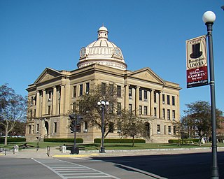
Logan County is a county located in the U.S. state of Illinois. According to the 2020 census, it had a population of 27,987. Its county seat is Lincoln.

<span class="mw-page-title-main">Christian County, Illinois</span> County in Illinois, United States

Christian County is a county located in the U.S. state of Illinois. As of the 2020 census, the population was 34,032. Its county seat is Taylorville.

<span class="mw-page-title-main">Cass County, Illinois</span> County in Illinois, United States

Cass County is a county located in the U.S. state of Illinois. As of the 2020 United States Census, the population was 13,042. Its county seat is Virginia. It is the home of the Jim Edgar Panther Creek State Fish and Wildlife Area.

<span class="mw-page-title-main">Argenta, Illinois</span> Village in Illinois, United States

Argenta is a village in Macon County, Illinois, United States, whose population was 913 at the 2020 census. It is included in the Decatur, Illinois Metropolitan Statistical Area.

<span class="mw-page-title-main">Niantic, Illinois</span> Village in Illinois, United States

Niantic is a village in Macon County, Illinois, United States. Its population was 612 at the 2020 census, down from 707 in 2010. It is included in the Decatur, Illinois Metropolitan Statistical Area.

<span class="mw-page-title-main">Athens, Illinois</span> City in Illinois, United States

AthensAY-thənz is a city in Menard County, Illinois, United States. The population was 1,977 at the 2020 census. It is part of the Springfield, Illinois Metropolitan Statistical Area.

<span class="mw-page-title-main">Greenview, Illinois</span> Village in Illinois, United States

Greenview is a village in Menard County, Illinois, United States. The population was 745 at the 2020 census. It is part of the Springfield, Illinois Metropolitan Statistical Area.

<span class="mw-page-title-main">Oakford, Illinois</span> Village in Illinois, United States

Oakford is a village in Menard County, Illinois, United States. The population was 234 at the 2020 census, down from 286 in 2010. It is part of the Springfield, Illinois Metropolitan Statistical Area.

<span class="mw-page-title-main">Petersburg, Illinois</span> City in Illinois, United States

Petersburg is a city in and the county seat of Menard County, Illinois, United States, on the bluffs and part of the floodplain overlooking the Sangamon River. It is part of the Springfield, Illinois Metropolitan Statistical Area. The population was 2,258 at the 2020 census, nearly unchanged from 2010. Petersburg is located approximately 2 miles (3 km) north of New Salem, the original location where Abraham Lincoln first settled, as he started his career.

<span class="mw-page-title-main">Tallula, Illinois</span> Village in Illinois, United States

Tallula is a village in Menard County, Illinois, United States. It was founded in 1857 by William G. Greene. The population was 434 at the 2020 census, down from 488 in 2010. It is part of the Springfield, Illinois Metropolitan Statistical Area.

<span class="mw-page-title-main">Cantrall, Illinois</span> Village in Illinois, United States

Cantrall is a village in Sangamon County, Illinois, United States. The population was 144 at the 2020 census, up from 139 in 2010. It is part of the Springfield, Illinois Metropolitan Statistical Area.

<span class="mw-page-title-main">Dawson, Illinois</span> Village in Illinois, United States

Dawson is a village in Sangamon County, Illinois, United States. The population was 519 at the 2020 census. It is about 10 miles (16 km) east of Springfield and is part of the Springfield Metropolitan Statistical Area.

<span class="mw-page-title-main">Divernon, Illinois</span> Village in Illinois, United States

Divernon is a village in Sangamon County, Illinois, United States. The population was 1,172 at the 2010 census, and 1,119 at a 2018 estimate. It is part of the Springfield, Illinois Metropolitan Statistical Area.

<span class="mw-page-title-main">Loami, Illinois</span> Village in Illinois, United States

Loami is a village in Sangamon County, Illinois, United States. The population was 745 at the 2010 census. It is part of the Springfield, Illinois Metropolitan Statistical Area. It is adjacent to the Nipper Wildlife Sanctuary, a parcel of tallgrass prairie replanted on the loam soil after which the village is named. The village was incorporated July 29, 1875

<span class="mw-page-title-main">New Berlin, Illinois</span> Village in Illinois, United States

New Berlin is a village in Sangamon County, Illinois, United States. The population was 1,346 at the 2010 census, and 1,327 at a 2018 estimate. It is part of the Springfield Metropolitan Statistical Area. New Berlin is home to CUSD #16, New Berlin High School.

References

  1. "Menard County, Illinois". United States Census Bureau . Retrieved June 10, 2023.
  2. Gannett, Henry (1905). The Origin of Certain Place Names in the United States. U.S. Government Printing Office. p. 205.
  3. 1 2 "Population, Housing Units, Area, and Density: 2010 - County". US Census Bureau. Archived from the original on February 13, 2020. Retrieved July 12, 2015.
  4. 1 2 "Monthly Averages for Petersburg IL". The Weather Channel. Retrieved January 27, 2011.
  5. "Annual Estimates of the Resident Population for Counties: April 1, 2020 to July 1, 2023". United States Census Bureau. Retrieved April 2, 2024.
  6. "US Decennial Census". US Census Bureau. Retrieved July 7, 2014.
  7. "Historical Census Browser". University of Virginia Library. Retrieved July 7, 2014.
  8. "Population of Counties by Decennial Census: 1900 to 1990". US Census Bureau. Retrieved July 7, 2014.
  9. "Census 2000 PHC-T-4. Ranking Tables for Counties: 1990 and 2000" (PDF). US Census Bureau. Retrieved July 7, 2014.
  10. "State & County QuickFacts". US Census Bureau. Archived from the original on June 7, 2011. Retrieved July 7, 2014.
  11. 1 2 3 "Profile of General Population and Housing Characteristics: 2010 Demographic Profile Data". US Census Bureau. Archived from the original on February 13, 2020. Retrieved July 12, 2015.
  12. "Selected Social Characteristics in the United States – 2006-2010 American Community Survey 5-Year Estimates". US Census Bureau. Archived from the original on February 13, 2020. Retrieved July 12, 2015.
  13. "Selected Economic Characteristics – 2006-2010 American Community Survey 5-Year Estimates". US Census Bureau. Archived from the original on February 13, 2020. Retrieved July 12, 2015.
  14. 60 ILCS 1/Art. 5
United States presidential election results for Menard County, Illinois [1]
Year Republican Democratic Third party
No.%No.%No.%
2020 4,76468.51%2,02229.08%1682.42%
2016 4,23164.94%1,81727.89%4677.17%
2012 3,94864.18%2,10034.14%1031.67%
2008 3,67256.69%2,70641.78%991.53%
2004 4,40867.05%2,13732.51%290.44%
2000 3,86262.27%2,16434.89%1762.84%
1996 3,10652.93%2,20437.56%5589.51%
1992 2,83444.99%2,26435.94%1,20119.07%
1988 3,56062.40%2,10336.86%420.74%
1984 3,92568.07%1,82631.67%150.26%
1980 3,62265.45%1,58928.71%3235.84%
1976 3,13757.25%2,30142.00%410.75%
1972 3,65769.49%1,58730.15%190.36%
1968 2,98059.66%1,64032.83%3757.51%
1964 2,32248.24%2,49151.76%00.00%
1960 3,12060.08%2,06839.82%50.10%
1956 3,18863.44%1,83336.48%40.08%
1952 3,30762.92%1,94637.02%30.06%
1948 2,89958.35%2,04341.12%260.52%
1944 3,01361.17%1,88838.33%250.51%
1940 3,53154.68%2,89444.81%330.51%
1936 3,06748.86%3,15250.22%580.92%
1932 2,32739.96%3,45359.30%430.74%
1928 3,24364.54%1,74234.67%400.80%
1924 2,93156.18%1,95437.45%3326.36%
1920 2,88259.19%1,86438.28%1232.53%
1916 2,69348.45%2,68948.38%1763.17%
1912 62019.53%1,53048.19%1,02532.28%
1908 1,60045.56%1,74849.77%1644.67%
1904 1,70549.46%1,50643.69%2366.85%
1900 1,63243.25%2,07855.08%631.67%
1896 1,64244.28%2,01854.42%481.29%
1892 1,27839.03%1,74853.39%2487.57%

40°02′N89°48′W / 40.03°N 89.80°W / 40.03; -89.80

  1. Leip, David. "Atlas of US Presidential Elections". uselectionatlas.org. Retrieved April 1, 2018.