Douglas County, Illinois

Last updated

Douglas County
Douglas County Illinois Courthouse Monument.jpg
Douglas County Courthouse and veterans' memorial
Map of Illinois highlighting Douglas County.svg
Location within the U.S. state of Illinois
Illinois in United States.svg
Illinois's location within the U.S.
Coordinates: 39°46′N88°13′W / 39.77°N 88.22°W / 39.77; -88.22
CountryFlag of the United States.svg United States
StateFlag of Illinois.svg  Illinois
Founded1859
Named for Stephen A. Douglas
Seat Tuscola
Largest cityTuscola
Area
  Total417 sq mi (1,080 km2)
  Land416 sq mi (1,080 km2)
  Water0.6 sq mi (2 km2)  0.1%
Population
 (2020)
  Total19,740
  Estimate 
(2021) [1]
19,722
  Density47/sq mi (18/km2)
Time zone UTC−6 (Central)
  Summer (DST) UTC−5 (CDT)
Congressional district 15th
Website www.douglascountyil.com

Douglas County is a county located in the U.S. state of Illinois. As of the 2020 United States Census, the population was 19,740. [2] The county seat is Tuscola. [3]

Contents

History

Douglas County was formed in 1859 out of Coles County. It was named for Stephen A. Douglas, [4] who was elected to the United States Senate in 1858, following the Lincoln–Douglas debates.

Geography

The west face of the Douglas County courthouse Douglas County Illinois Courthouse.jpg
The west face of the Douglas County courthouse

According to the US Census Bureau, the county has a total area of 417 square miles (1,080 km2), of which 417 square miles (1,080 km2) is land and 0.6 square miles (1.6 km2) (0.1%) is water. [5]

Climate and weather

Tuscola, Illinois
Climate chart (explanation)
J
F
M
A
M
J
J
A
S
O
N
D
 
 
2.3
 
 
34
18
 
 
2.1
 
 
41
23
 
 
3.1
 
 
53
33
 
 
3.8
 
 
66
42
 
 
4
 
 
76
53
 
 
4.2
 
 
85
62
 
 
4.6
 
 
88
66
 
 
3.7
 
 
86
64
 
 
3.1
 
 
80
56
 
 
2.9
 
 
68
45
 
 
3.7
 
 
52
35
 
 
3.1
 
 
39
24
Average max. and min. temperatures in °F
Precipitation totals in inches
Source: The Weather Channel [6]
Metric conversion
J
F
M
A
M
J
J
A
S
O
N
D
 
 
58
 
 
1
−8
 
 
54
 
 
5
−5
 
 
80
 
 
12
1
 
 
98
 
 
19
6
 
 
101
 
 
24
12
 
 
105
 
 
29
17
 
 
118
 
 
31
19
 
 
95
 
 
30
18
 
 
80
 
 
27
13
 
 
73
 
 
20
7
 
 
95
 
 
11
2
 
 
77
 
 
4
−4
Average max. and min. temperatures in °C
Precipitation totals in mm

In recent years, average temperatures in the county seat of Tuscola have ranged from a low of 18 °F (−8 °C) in January to a high of 88 °F (31 °C) in July, although a record low of −26 °F (−32 °C) was recorded in December 1989 and a record high of 113 °F (45 °C) was recorded in July 1954. Average monthly precipitation ranged from 2.12 inches (54 mm) in February to 4.64 inches (118 mm) in July. [6]

Adjacent counties

Major highways

Demographics

Historical population
CensusPop.Note
1860 7,140
1870 13,48488.9%
1880 15,85317.6%
1890 17,66911.5%
1900 19,0978.1%
1910 19,5912.6%
1920 19,6040.1%
1930 17,914−8.6%
1940 17,590−1.8%
1950 16,706−5.0%
1960 19,24315.2%
1970 18,997−1.3%
1980 19,7744.1%
1990 19,464−1.6%
2000 19,9222.4%
2010 19,9800.3%
2020 19,740−1.2%
2023 (est.)19,629 [7] −0.6%
US Decennial Census [8]
1790-1960 [9] 1900-1990 [10]
1990-2000 [11] 2010-2014 [12] 2020 [2]
2000 census age pyramid for Douglas County USA Douglas County, Illinois age pyramid.svg
2000 census age pyramid for Douglas County

As of the 2010 United States Census, there were 19,980 people, 7,720 households, and 5,377 families living in the county. [13] The population density was 48.0 inhabitants per square mile (18.5/km2). There were 8,390 housing units at an average density of 20.1 per square mile (7.8/km2). [5] The racial makeup of the county was 95.7% white, 0.4% Asian, 0.3% black or African American, 0.2% American Indian, 2.3% from other races, and 1.2% from two or more races. Those of Hispanic or Latino origin made up 6.1% of the population. [13] In terms of ancestry, 29.6% were German, 12.6% were American, 12.1% were English, and 10.7% were Irish. [14]

Of the 7,720 households, 32.6% had children under the age of 18 living with them, 57.0% were married couples living together, 8.5% had a female householder with no husband present, 30.3% were non-families, and 26.1% of all households were made up of individuals. The average household size was 2.57 and the average family size was 3.11. The median age was 38.7 years. [13]

The median income for a household in the county was $46,941 and the median income for a family was $60,352. Males had a median income of $41,318 versus $28,731 for females. The per capita income for the county was $21,438. About 7.1% of families and 10.2% of the population were below the poverty line, including 14.0% of those under age 18 and 7.2% of those age 65 or over. [15]

Communities

Map of Douglas County, Illinois Map of Douglas County Illinois.png
Map of Douglas County, Illinois

Cities

Villages

Unincorporated communities

Townships

Politics

Douglas is a strongly Republican county. Apart from a narrow plurality of thirty-two votes to Bill Clinton in 1992, it has voted Republican in every Presidential election since 1968, and in all but five overall since 1880. Despite its long-time Republican leanings, Hillary Clinton's 2016 performance of gaining a mere 23.8 percent of the county's vote stands over six percent worse than any Democrat since the Civil War.

United States presidential election results for Douglas County, Illinois [16]
Year Republican Democratic Third party
No.%No.%No.%
2020 6,22771.08%2,33526.66%1982.26%
2016 5,69869.53%1,94923.78%5486.69%
2012 5,33467.34%2,43030.68%1571.98%
2008 5,00559.73%3,22838.52%1461.74%
2004 5,70266.77%2,76732.40%710.83%
2000 4,73458.07%3,21539.44%2032.49%
1996 3,27246.66%2,95542.14%78611.21%
1992 3,30939.98%3,34140.37%1,62619.65%
1988 4,37857.62%3,18441.91%360.47%
1984 5,69166.14%2,88633.54%270.31%
1980 5,33064.26%2,56430.91%4004.82%
1976 4,63554.39%3,82644.90%610.72%
1972 5,84068.66%2,65631.23%100.12%
1968 5,05859.25%2,82433.08%6557.67%
1964 4,22347.35%4,69552.65%00.00%
1960 5,76161.95%3,53237.98%60.06%
1956 5,55966.66%2,77433.27%60.07%
1952 5,53067.10%2,70632.84%50.06%
1948 4,18158.65%2,89340.58%550.77%
1944 4,68458.29%3,32341.36%280.35%
1940 5,45154.34%4,51344.99%670.67%
1936 4,60647.51%5,02951.88%590.61%
1932 3,10837.74%4,95460.15%1742.11%
1928 4,89068.19%2,23931.22%420.59%
1924 4,04655.65%2,31531.84%90912.50%
1920 4,88565.21%2,30830.81%2983.98%
1916 4,56452.17%3,76843.07%4164.76%
1912 1,38631.03%1,63336.56%1,44832.42%
1908 2,65655.33%1,91739.94%2274.73%
1904 2,51854.80%1,68536.67%3928.53%
1900 2,73355.46%2,10642.74%891.81%
1896 2,66654.78%2,14043.97%611.25%
1892 2,24650.48%1,99944.93%2044.59%

See also

Related Research Articles

<span class="mw-page-title-main">Shelby County, Illinois</span> County in Illinois, United States

Shelby County is a county located in the U.S. state of Illinois. According to the 2020 census, it had a population of 20,990. Its county seat is Shelbyville.

<span class="mw-page-title-main">Scott County, Illinois</span> County in Illinois, United States

Scott County is a county located in the U.S. state of Illinois. According to the 2020 census, it had a population of 4,949, making it the fourth-least populous county in Illinois. Its county seat is Winchester.

<span class="mw-page-title-main">Piatt County, Illinois</span> County in Illinois, United States

Piatt County is a county in Illinois. According to the 2020 United States Census, it had a population of 16,673. Its county seat is Monticello.

<span class="mw-page-title-main">Moultrie County, Illinois</span> County in Illinois, United States

Moultrie County is a county in the U.S. state of Illinois. According to the 2020 United States Census, its population was 14,526. Its county seat is Sullivan. The name is pronounced as in "mole tree", unlike the pronunciation of its namesake, the South Carolinian Revolutionary War hero William Moultrie.

<span class="mw-page-title-main">Johnson County, Illinois</span> County in Illinois, United States

Johnson County is a county in the U.S. state of Illinois. According to the 2020 census, it has a population of 13,308. Its county seat is Vienna. It is located in the southern portion of Illinois known locally as "Little Egypt".

<span class="mw-page-title-main">Arcola, Illinois</span> City in Illinois, United States

Arcola is a city in Douglas County, Illinois, United States. The population was 2,927 at the 2020 census. The city was founded in 1855, when the Illinois Central Railroad was built through the county. The railroad itself was responsible for surveying, platting and founding the town.

<span class="mw-page-title-main">Arthur, Illinois</span> Village in Illinois, United States

Arthur is a village in Douglas and Moultrie counties in Illinois, with Arthur's primary street, Vine Street, being the county line. The population was 2,231 at the 2020 census. The Arthur area is home to the largest and oldest Amish community in Illinois, which was founded in the 1860s.

<span class="mw-page-title-main">Tuscola, Illinois</span> City in Illinois, United States

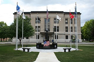
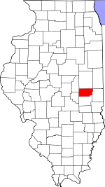
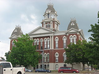
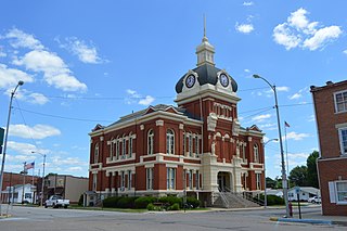
Tuscola is a city in Douglas County, Illinois, United States. The population was 4,636 at the 2020 census. It is the county seat of Douglas County.

Lake Catherine is an unincorporated community and census-designated place (CDP) in Lake County, Illinois, United States. Per the 2020 census, the population was 1,279.

<span class="mw-page-title-main">Long Creek, Illinois</span> Village in Illinois, United States

Long Creek is a village in Macon County, Illinois, United States. As of the 2020 census there were 1,261 people. It is included in the Decatur, Illinois Metropolitan Statistical Area.

<span class="mw-page-title-main">Central City, Illinois</span> Village in Illinois, United States

Central City is a village in Marion County, Illinois, United States. The population was 1,098 at the 2020 census.

Tuscola Township is a civil township of Tuscola County in the U.S. state of Michigan. The population was 2,082 at the 2010 Census.

<span class="mw-page-title-main">North Okaw Township, Coles County, Illinois</span> Township in Illinois, United States

North Okaw Township is one of twelve townships in Coles County, Illinois, United States. As of the 2020 census, its population was 1,004 and it contained 366 housing units. The Kaskaskia River flows through the township. The Cook Mills Consolidated oil field is within this township. The township changed its name from Okaw Township on May 7, 1860.

<span class="mw-page-title-main">Arcola Township, Douglas County, Illinois</span> Township in Illinois, United States

Arcola Township is one of nine townships in Douglas County, Illinois, USA. As of the 2020 census, its population was 3,257 and it contained 1,316 housing units.

<span class="mw-page-title-main">Bourbon Township, Douglas County, Illinois</span> Township in Illinois, United States

Bourbon Township is one of nine townships in Douglas County, Illinois, USA. As of the 2020 census, its population was 4,099 and it contained 1,402 housing units.

<span class="mw-page-title-main">Bowdre Township, Douglas County, Illinois</span> Township in Illinois, United States

Bowdre Township is one of nine townships in Douglas County, Illinois, USA. As of the 2020 census, its population was 620 and it contained 311 housing units. Its name was changed from Deer Creek to Bowdre on June 5, 1868.

<span class="mw-page-title-main">Camargo Township, Douglas County, Illinois</span> Township in Illinois, United States

Camargo Township is one of nine townships in Douglas County, Illinois, USA. As of the 2020 census, its population was 3,538 and it contained 1,569 housing units.

<span class="mw-page-title-main">Garrett Township, Douglas County, Illinois</span> Township in Illinois, United States

Garrett Township is one of nine townships in Douglas County, Illinois, USA. As of the 2020 census, its population was 1,292 and it contained 579 housing units.

<span class="mw-page-title-main">Tuscola Township, Douglas County, Illinois</span> Township in Illinois, United States

Tuscola Township is one of nine townships in Douglas County, Illinois, USA. As of the 2020 census, its population was 5,460 and it contained 2,563 housing units.

<span class="mw-page-title-main">Douglas Township, Effingham County, Illinois</span> Township in Illinois, United States

Douglas Township is one of fifteen townships in Effingham County, Illinois, USA. As of the 2020 census, its population was 12,556 and it contained 5,947 housing units.

References

  1. "QuickFacts: Douglas County, Illinois". Census.gov. Retrieved May 24, 2022.
  2. 1 2 2020 Population and Housing State Data | Illinois
  3. "Find a County". National Association of Counties. Archived from the original on May 31, 2011. Retrieved June 7, 2011.
  4. Gannett, Henry (1905). The Origin of Certain Place Names in the United States. Govt. Print. Off. p. 108.
  5. 1 2 "Population, Housing Units, Area, and Density: 2010 - County". US Census Bureau. Archived from the original on February 12, 2020. Retrieved July 11, 2015.
  6. 1 2 "Monthly Averages for Tuscola IL". The Weather Channel. Retrieved January 27, 2011.
  7. "Annual Estimates of the Resident Population for Counties: April 1, 2020 to July 1, 2023". United States Census Bureau. Retrieved April 2, 2024.
  8. "US Decennial Census". US Census Bureau. Retrieved July 4, 2014.
  9. "Historical Census Browser". University of Virginia Library. Retrieved July 4, 2014.
  10. "Population of Counties by Decennial Census: 1900 to 1990". US Census Bureau. Retrieved July 4, 2014.
  11. "Census 2000 PHC-T-4. Ranking Tables for Counties: 1990 and 2000" (PDF). US Census Bureau. Archived (PDF) from the original on March 27, 2010. Retrieved July 4, 2014.
  12. "State & County QuickFacts". US Census Bureau. Archived from the original on June 6, 2011. Retrieved July 4, 2014.
  13. 1 2 3 "Profile of General Population and Housing Characteristics: 2010 Demographic Profile Data". US Census Bureau. Archived from the original on February 13, 2020. Retrieved July 11, 2015.
  14. "Selected Social Characteristics in the United States – 2006-2010 American Community Survey 5-Year Estimates". US Census Bureau. Archived from the original on February 13, 2020. Retrieved July 11, 2015.
  15. "Selected Economic Characteristics – 2006-2010 American Community Survey 5-Year Estimates". US Census Bureau. Archived from the original on February 13, 2020. Retrieved July 11, 2015.
  16. Leip, David. "Atlas of US Presidential Elections". uselectionatlas.org. Retrieved November 1, 2018.

39°46′N88°13′W / 39.77°N 88.22°W / 39.77; -88.22