Rock Falls, Illinois

Last updated

Rock Falls
SterlingIllinois.jpg
The Lawrence Hardware building (right) in Sterling overlooking the bridge to Rock Falls, Illinois
Whiteside County Illinois Incorporated and Unincorporated areas Rock Falls Highlighted.svg
Location of Rock Falls in Whiteside County, Illinois.
Illinois in United States (US48).svg
Location of Illinois in the United States
Coordinates: 41°46′29″N89°41′29″W / 41.77472°N 89.69139°W / 41.77472; -89.69139
CountryUnited States
StateIllinois
County Whiteside
Founded byA.P. Smith
Government
  TypeMayor-council
  MayorRodney Kleckler
  City AttorneyJames L. Reese
Area
[1]
  Total4.12 sq mi (10.68 km2)
  Land3.98 sq mi (10.32 km2)
  Water0.14 sq mi (0.36 km2)
Population
 (2020)
  Total8,789
  Density2,206.63/sq mi (852.02/km2)
Time zone UTC−6 (CST)
  Summer (DST) UTC−5 (CDT)
ZIP Code(s)
61071
Area code 815
FIPS code 17-64928
Wikimedia CommonsRock Falls, Illinois
Website rockfalls61071.net

Rock Falls is a city in Whiteside County, Illinois, United States. The recorded population was 8,606 at the 2020 census, down 7.12% from 9,266 in 2010. The city is located on the Rock River, directly opposite its twin city of Sterling.

Contents

Geography

Rock Falls is separated from its twin city, Sterling, to the North by the Rock River.

According to the 2010 census, Rock Falls has a total area of 3.795 square miles (9.83 km2), of which 3.66 square miles (9.48 km2) (or 96.44%) is land and 0.135 square miles (0.35 km2) (or 3.56%) is water. [2]

Demographics

Historical population
CensusPop.Note
1870 471
1880 89489.8%
1890 1,900112.5%
1900 2,17614.5%
1910 2,65722.1%
1920 2,92710.2%
1930 3,89333.0%
1940 4,98728.1%
1950 7,98360.1%
1960 10,26128.5%
1970 10,2870.3%
1980 10,6333.4%
1990 9,654−9.2%
2000 9,580−0.8%
2010 9,266−3.3%
2020 8,789−5.1%
U.S. Decennial Census [3]

At the 2000 census there were 9,580 people, 3,895 households, and 2,559 families living in the city. The population density was 2,888.0 inhabitants per square mile (1,115.1/km2). There were 4,098 housing units at an average density of 1,235.4 per square mile (477.0/km2). The racial makeup of the city was 91.78% White, 0.88% African American, 0.45% Native American, 0.26% Asian, 4.71% from other races, and 1.92% from two or more races. Hispanic or Latino of any race were 11.54%. [4]

Of the 3,895 households 30.7% had children under the age of 18 living with them, 47.5% were married couples living together, 13.7% had a female householder with no husband present, and 34.3% were non-families. 29.4% of households were one person and 13.9% were one person aged 65 or older. The average household size was 2.43 and the average family size was 2.99.

The age distribution was 25.5% under the age of 18, 9.0% from 18 to 24, 27.6% from 25 to 44, 21.9% from 45 to 64, and 15.9% 65 or older. The median age was 36 years. For every 100 females, there were 90.8 males. For every 100 females age 18 and over, there were 87.5 males.

The median household income was $34,442 and the median family income was $41,803. Males had a median income of $32,733 versus $21,092 for females. The per capita income for the city was $16,524. About 10.3% of families and 11.5% of the population were below the poverty line, including 14.8% of those under age 18 and 6.8% of those age 65 or over.

Education

Rock Falls has 4 school districts. Rock Falls Elementary School District #13 consists of Riverdale Preschool Center, Dillon Elementary School, Merrill Intermediate School, and Rock Falls Middle School. East Coloma-Nelson CESD #20 operates East Coloma-Nelson grade school. Montmorency CCSD #145 operates Montmorency grade school. Thome School serves as the towns special needs institution.

The Roman Catholic Diocese of Rockford runs one school in the city: St. Andrew's School, serving as both grade school and middle school. This school serves a local parish, St. Andrew Catholic Church.

Arts and culture

The City of Rock Falls hosts many annual events each year. Some of the most popular events are: Percussion-Paloosa (February), Rock Falls Spring Challenge (May), Bass Pro Shop's Big Cat Quest Catfish Tournament (June), Summer Splash (June), River Chase Boat Races (June), Pink Heals Tour (July), Whiteside County Barn Tour (July), Touch a Truck (August), Fiesta Days (September), Bridge the Communities 5K/10K race (September), The Hennepin Hundred 100k Ultra race (October) and Hometown Holidays (November).[ citation needed ]

Parks and recreation

The City of Rock Falls and Township of Coloma have 16 parks spanning over 100 acres (40 ha) in which one can use baseball diamonds, basketball courts, tennis courts, disc golf, open fields, playground equipment, pavilions, picnic areas, or a bandshell. Also, with the close proximity of the Rock River, the Hennepin Canal, and a lake in Centennial Park where one can use boats ramps, canoes, paddle boats, or engage in fishing.

Hennepin Canal, looking south from its origin on the Rock River in Rock Falls, Illinois. PXL 20210428 143701947.jpg
Hennepin Canal, looking south from its origin on the Rock River in Rock Falls, Illinois.

Two eighteen-hole mid-range disc golf courses are located in Rock Falls: Nims Park [5] and Joshua Park. [6]

Infrastructure

Airport

The Whiteside County Airport is located about 2 mi (3.2 km) south of the city.

Major highways

Major highways in Rock Falls include:

Electric utility

Rock Falls has a municipal electrical system, which generates its own power using a 2 megawatt low-head hydro-electric plant on the Rock River. Current electric rate is 67% higher than Com Ed. Water and sewer minimum charge is now up to $71.85. [7]

Notable people

Related Research Articles

<span class="mw-page-title-main">Whiteside County, Illinois</span> County in Illinois, United States

Whiteside County is a county located in the U.S. state of Illinois. According to the 2020 census, it had a population of 55,691. Its county seat is Morrison. The county is bounded on the west by the Mississippi River. Whiteside County comprises the Sterling, IL Micropolitan Statistical Area, which is also included in the Dixon-Sterling, IL Combined Statistical Area. U.S. President Ronald Reagan was born in 1911 in the Whiteside County community of Tampico.

<span class="mw-page-title-main">Rock Island County, Illinois</span> County in Illinois, United States

Rock Island County is a county located in the U.S. state of Illinois, bounded on the west by the Mississippi River. According to the 2020 census, it had a population of 144,672. Its county seat is Rock Island; its largest city is neighboring Moline. Rock Island County is one of the four counties that make up the Davenport-Moline-Rock Island, IA-IL Metropolitan Statistical Area.

<span class="mw-page-title-main">Colona, Illinois</span> City in Illinois, United States

Colona is a city in Henry County, Illinois, along the Green River. It is part of the Quad Cities metropolitan area. The population was 5,307 at the 2020 census, up from 5,099 at the 2010 census.

<span class="mw-page-title-main">Morrison, Illinois</span> City in Illinois, United States

Morrison is a city in Whiteside County, Illinois, United States. The population was 4,188 at the 2010 census, down from 4,447 in 2000. It is the county seat of Whiteside County. It is located on the Historic Lincoln Highway, the nation's first transcontinental highway and in Morrison was the site of two concrete "seedling miles", which served as prototypes of what an improved highway could do for the nation.

<span class="mw-page-title-main">Prophetstown, Illinois</span> City in Illinois, United States

Prophetstown is a city in Whiteside County, Illinois, United States. The population was 2,080 at the 2010 census, up from 2,023 in 2000.

<span class="mw-page-title-main">Sterling, Illinois</span> City in Illinois, United States

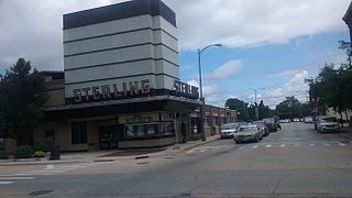
Sterling is a city in Whiteside County, Illinois, United States. The population was 14,782 at the 2020 census, down from 15,370 in 2010. Formerly nicknamed "Hardware Capital of the World", the city has long been associated with manufacturing and the steel industry.

<span class="mw-page-title-main">Tampico, Illinois</span> Village in Illinois, United States

Tampico is a village located in Tampico Township, Whiteside County, Illinois, United States next to Rock Falls and Sterling, Illinois. As of the 2010 census the village had a total population of 790, up from 772 at the 2000 census. It is known as the birthplace of Ronald Reagan, the 40th President of the United States.

<span class="mw-page-title-main">Nora Springs, Iowa</span> City in Iowa, United States

Nora Springs is a city that is partially in Cerro Gordo and Floyd counties in the U.S. state of Iowa, along the Shell Rock River. The population was 1,369 at the time of the 2020 census.

<span class="mw-page-title-main">Utica, Michigan</span> City in Michigan, United States

Utica is a city in Macomb County in the U.S. state of Michigan. The population was 5,245 at the 2020 census, up from 4,757 in 2010.

<span class="mw-page-title-main">Ocqueoc Township, Michigan</span> Civil township in Michigan, United States

Ocqueoc Township is a civil township of Presque Isle County in the U.S. state of Michigan named after the Ocqueoc River. The population of Ocqueoc Township was 634 at the 2000 census and slightly increased at 655 at the 2010 census.

<span class="mw-page-title-main">Anoka, Minnesota</span> City in Minnesota, United States

Anoka is a city in and the county seat of Anoka County, Minnesota, United States. Its population was 17,142 at the 2010 census. Anoka is the "Halloween Capital of the World" because it hosted one of the first Halloween parades in 1920. It continues to celebrate the holiday each year with several parades. Anoka is a northern suburb of the Twin Cities. U.S. Highways 10 / 169 and State Highway 47 are three of Anoka's main routes, and it has a station on the Northstar Commuter Rail line to Minneapolis.

<span class="mw-page-title-main">Brooklyn Park, Minnesota</span> City in Minnesota, United States

Brooklyn Park is a suburban city on the west bank of the Mississippi River, upstream from downtown Minneapolis in northern Hennepin County. It is the sixth-largest city in the U.S. state of Minnesota. The population was 86,478 at the 2020 census. The city still has undeveloped land and farms, including the historic Eidem Homestead, a 1900s working farm that is a popular tourist attraction for families and school field trips. Brooklyn Park is considered both a second- and third-tier suburb of Minneapolis, because much of the land north of 85th Avenue was developed after 2000.

<span class="mw-page-title-main">Champlin, Minnesota</span> City in Minnesota, United States

Champlin is a city in Hennepin County, Minnesota, United States. The population was 23,919 at the 2020 census. Champlin is a northern suburb of Minneapolis.

<span class="mw-page-title-main">Vermillion, South Dakota</span> City in South Dakota, United States

Vermillion is a city and the county seat of Clay County. It is in the southeastern corner of South Dakota, United States, and is the state's 12th-most populous city. According to the 2020 Census, the population was 11,695. The city lies atop a bluff near the Missouri River.

<span class="mw-page-title-main">Great Falls, Virginia</span> Census-designated place in Virginia, United States

Great Falls is a census-designated place in Fairfax County, Virginia, United States. The population at the 2020 census was 15,953.

<span class="mw-page-title-main">Hanover, Minnesota</span> City in Minnesota, United States

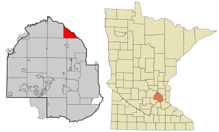
Hanover is a city in Wright and Hennepin counties in the U.S. state of Minnesota. The population was 3,548 at the 2020 census. Hanover is mainly located within Wright County; only a small part of the city extends into Hennepin County.

<span class="mw-page-title-main">Rockford, Minnesota</span> City in Minnesota, United States

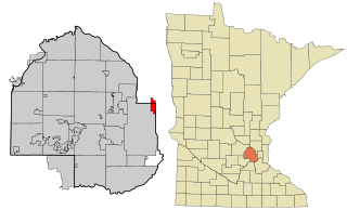
Rockford is a city in Wright and Hennepin counties in the U.S. state of Minnesota. The population was 4,316 at the 2010 census. While Rockford is mainly located within Wright County, a small part of the city extends into Hennepin County. It is part of the Minneapolis–Saint Paul metropolitan statistical area. Minnesota State Highway 55 serves as a main route in the city.

<span class="mw-page-title-main">River Falls, Wisconsin</span> City in Wisconsin, United States

River Falls is a city in Pierce and St. Croix counties in the U.S. state of Wisconsin. It is located mostly within the town of River Falls, and adjacent to the town of Kinnickinnic in St. Croix County. River Falls is the most populous city in Pierce County. The population was 16,182 at the 2020 census, with 11,851 residing in Pierce County and 3,149 in St. Croix County. It is part of the Minneapolis-St. Paul metropolitan area and located approximately 30 miles (48 km) east of the center of that region.

<span class="mw-page-title-main">St. Croix Falls, Wisconsin</span> City in Wisconsin, United States

St. Croix Falls is a city in Polk County, Wisconsin, United States. The population was 2,208 at the 2020 census. The city is located within the Town of St. Croix Falls.

<span class="mw-page-title-main">St. Anthony, Minnesota</span> City in Minnesota, United States

St. Anthony, also known as Saint Anthony Village, is a city in Hennepin and Ramsey counties in the U.S. state of Minnesota. The population was 9,257 at the 2020 census, of whom 5,621 lived in the larger Hennepin County part of the city and 3,654 in the Ramsey County part. The city is run by a five-member council consisting of a mayor and four council members who serve four-year terms.

References

  1. "2020 U.S. Gazetteer Files". United States Census Bureau. Retrieved March 15, 2022.
  2. "G001 - Geographic Identifiers - 2010 Census Summary File 1". United States Census Bureau. Archived from the original on February 13, 2020. Retrieved December 27, 2015.
  3. "Census of Population and Housing". Census.gov. Retrieved June 4, 2015.
  4. "U.S. Census website". United States Census Bureau . Retrieved January 31, 2008.
  5. "Nims Park". September 2, 2009.
  6. "Joshua Park". February 27, 2015.
  7. "Electric Department". City of Rock Falls. Retrieved April 23, 2021.