
Whiteside County is a county located in the U.S. state of Illinois. According to the 2020 census, it had a population of 55,691. Its county seat is Morrison. The county is bounded on the west by the Mississippi River. Whiteside County comprises the Sterling, IL Micropolitan Statistical Area, which is also included in the Dixon-Sterling, IL Combined Statistical Area. U.S. President Ronald Reagan was born in 1911 in the Whiteside County community of Tampico.

Lake County is situated in the northeastern corner of the U.S. state of Illinois, along the shores of Lake Michigan. As of the 2020 census, it has a population of 714,342, making it the third-most populous county in Illinois. Its county seat is Waukegan, the tenth-largest city in Illinois. The county is primarily suburban, with some urban areas and some rural areas. Due to its location, immediately north of Cook County, Lake County is one of the collar counties of the Chicago metropolitan area. Its northern boundary is the Wisconsin state line.
Iroquois County is a county located in the northeast part of the U.S. state of Illinois. According to the 2020 United States Census, it has a population of 27,077. It is the only county in the United States to be named Iroquois, after the American Indian people. The county seat is Watseka. The county is located along the border with Indiana.

Poplar Grove is a village located in Poplar Grove and Belvidere Townships, Boone County, Illinois, United States. It is part of the Rockford Metropolitan Statistical Area, and of the gated community Candlewick Lake. The population was 5,049 at the 2020 census.
Troy Grove is a village in LaSalle County, Illinois, United States. The population was 225 at the 2020 census, down from 250 at the 2010 census. It is part of the Ottawa, IL Micropolitan Statistical Area.
Fulton is a city in Whiteside County, Illinois, United States. The population was 3,481 at the 2010 census, down from 3,881 in 2000. Fulton is located across the Mississippi River from Clinton, Iowa.

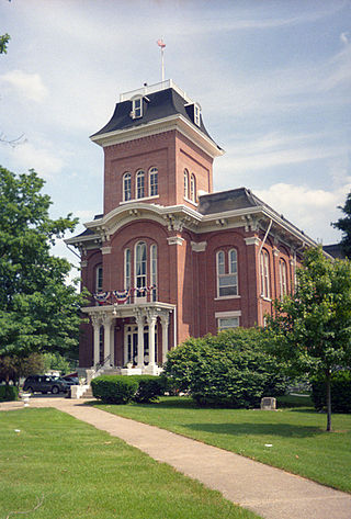
Morrison is a city in Whiteside County, Illinois, United States. The population was 4,188 at the 2010 census, down from 4,447 in 2000. It is the county seat of Whiteside County. It is located on the Historic Lincoln Highway, the nation's first transcontinental highway and in Morrison was the site of two concrete "seedling miles", which served as prototypes of what an improved highway could do for the nation.

Forgottonia, also spelled Forgotonia, is the name given to a 16-county region in Western Illinois in the late 1960s and early 1970s. This geographic region forms the distinctive western bulge of Illinois that is roughly equivalent to "The Tract", the Illinois portion of the Military Tract of 1812, along and west of the Fourth Principal Meridian. Since this wedge-shaped region lies between the Illinois and Mississippi rivers, it has historically been isolated from the eastern portion of Central Illinois.

Triumph is an unincorporated community and Census Designated Place located just east of Interstate 39 in LaSalle County, Illinois, United States. Students in Triumph attend nearby Mendota public schools. The village is home to one restaurant and is known for its curling club. The community has many farms surrounding it and contains fewer than 100 people.

Hahnaman Township is located in Whiteside County, Illinois. As of the 2010 census, its population was 399 and it contained 148 housing units.
Langley is an unincorporated community in Bureau County, Illinois, United States. Langley is located at the junction of U.S. Route 6, U.S. Route 34, and Illinois Route 40. Langley is east of Sheffield and north of Buda.
Galt is an unincorporated community in Whiteside County, Illinois, United States. Galt is 3 miles (4.8 km) west of Sterling and has a post office with ZIP code 61037.
Camp Grove is an unincorporated community in Marshall County, Illinois, United States, located 7.5 miles (12.1 km) east-northeast of Wyoming and 27.6 miles (44.4 km) north of Peoria. Camp Grove has a post office with ZIP code 61424.
Shabbona Grove is an unincorporated community in DeKalb County, Illinois, United States. Shabbona Grove is located on the south edge of Shabbona Lake State Park, 2.5 miles (4.0 km) south-southeast of Shabbona.
Akron is an unincorporated community in Peoria County, in the U.S. state of Illinois.
Eddy is an unincorporated community in Lake County, in the U.S. state of Illinois. Eddy is located at 42°27′41″N87°53′54″W.
Freeman is an unincorporated community in Kane County, in the U.S. state of Illinois.
Hahnaman is an unincorporated community in Whiteside County, in the U.S. state of Illinois.
Terra Cotta is an unincorporated community in McHenry County, in the U.S. state of Illinois.
Union Grove is an unincorporated community in Whiteside County, in the U.S. state of Illinois.


