
Bolton Field is a public airport in Columbus, in Franklin County, Ohio, United States. It is a towered airport operated under the Columbus Regional Airport Authority. It is one of 12 general aviation reliever airports in Ohio recognized in the National Plan of Integrated Airport Systems (NPIAS) and is a reliever airport for John Glenn Columbus International Airport.

Chicago Executive Airport, formerly Palwaukee Municipal Airport, is a public airport 18 miles (33 km) northwest of Chicago, in the village of Wheeling in Cook County, Illinois, United States. It is owned by the City of Prospect Heights and the Village of Wheeling.
Shelby County Airport is a public airport located three miles (4.8 km) west of the central business district (CBD) of Shelbyville, a city in Shelby County, Illinois, United States. A significant amount of the airport's traffic is from agricultural aviation serving nearby areas.
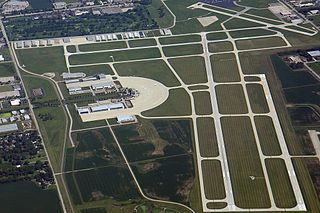
DuPage Airport is a general aviation airport located 29 miles (47 km) west of downtown Chicago in West Chicago, DuPage County, Illinois, United States. It is owned and operated by the DuPage Airport Authority, which is an independent government body established by law by the State of Illinois. It also serves as a relief airport for O'Hare International Airport and Chicago Midway International Airport, both in nearby Chicago.
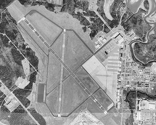
Smyrna Airport is a public general aviation and military use airport located two nautical miles (4 km) north of the central business district of Smyrna, a town in Rutherford County, Tennessee, United States. It is owned by Smyrna / Rutherford County Airport Authority. Smyrna Airport is the third largest airport in Tennessee and is the state's busiest general aviation airport. Prior to March 1971, the facility was an active military installation known as Sewart Air Force Base.
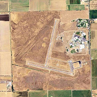
Franklin Field, formerly Q53, is a public airport located four miles (6 km) southeast of the central business district (CBD) of Franklin in Sacramento County, California, United States. It is mostly used for general aviation. The airport was used for bomber training during World War II, and in 1947 it was acquired by the County of Sacramento.

Southern Illinois Airport is a public airport in Jackson County, Illinois, United States. It is located three nautical miles (6 km) northwest of the central business district of Carbondale and east of Murphysboro. This airport is included in the FAA's National Plan of Integrated Airport Systems for 2015–2019, which categorized it as a general aviation facility.

Lebanon-Warren County Airport is a public airport located three miles (5 km) northwest of the central business district of Lebanon, on Greentree Road, in Warren County, Ohio, United States.
Rantoul National Aviation Center, also known as Frank Elliott Field, is a public use airport located in Rantoul, a village in Champaign County, Illinois, United States. It is owned by the Village of Rantoul.

Conroe-North Houston Regional Airport is a public-use airport in Conroe, Texas, United States, 37 miles (60 km) north of the central business district of Houston. It is publicly owned by Montgomery County.
Anderson Municipal Airport is a public use airport three miles east of Anderson in Madison County, Indiana. The National Plan of Integrated Airport Systems for 2011–2015 categorized it as a general aviation facility. The airport currently has no scheduled air service.
M. Graham Clark Downtown Airport is a county-owned, public-use airport in Taney County, Missouri, United States. It is located one nautical mile (2 km) south of the central business district of Branson, Missouri, one nautical mile (2 km) northeast of Point Lookout, Missouri, and a few yards west of the old downtown area of Hollister, Missouri. It was formerly known as M. Graham Clark Field – Taney County Airport.
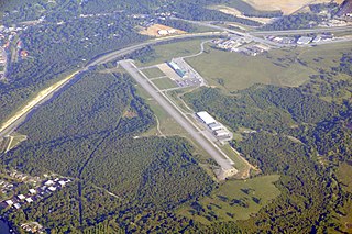
Covington Municipal Airport is a city-owned public-use airport located three nautical miles north of the central business district of Covington, a city in Newton County, Georgia, United States.
Sparta Community Airport, also known as Hunter Field, is a civil, public use airport 2 miles north of Sparta, Illinois. The airport is publicly owned by the Sparta Community Airport Authority.
Dwight Airport is a public-use airport located three miles north of Dwight, Illinois. The airport is privately owned by the Dwight Aero Service.
Oceana County Airport is a public use airport located between the cities of Hart and Shelby, Michigan. It is publicly owned by the Oceana County Court House.
Boyne City Municipal Airport is a public use airport located in the city limits of Boyne City, Michigan. The airport is publicly owned by the City of Boyne City. It is four nautical miles southeast of the similarly named Boyne Mountain Airport.
Highland-Winet Airport is a public-use airport located 3 miles northeast of Highland, Illinois. The airport is privately owned by the St. Louis Soaring Association.
Marlette Township Airport is a public use airport located one mile southwest of Marlette, Michigan. The airport is publicly owned by Marlette Township.
Dupoint-Lapeer Airport is a public use airport located two miles (3.2 km) northeast of Lapeer in Mayfield Township, Lapeer County, Michigan. The airport is publicly owned by the township.
