Knox County, Illinois

Last updated

Knox County
Knox County Courthouse (Illinois) 1981.jpg
Map of Illinois highlighting Knox County.svg
Location within the U.S. state of Illinois
Illinois in United States.svg
Illinois's location within the U.S.
Coordinates: 40°56′N90°13′W / 40.93°N 90.21°W / 40.93; -90.21
CountryFlag of the United States.svg United States
StateFlag of Illinois.svg  Illinois
Founded1825
Named for Henry Knox
Seat Galesburg
Largest cityGalesburg
Government
  Board ChairmanJared Hawkinson
Area
  Total720 sq mi (1,900 km2)
  Land716 sq mi (1,850 km2)
  Water3.4 sq mi (9 km2)  0.5%
Population
 (2020)
  Total49,967
  Density69/sq mi (27/km2)
Time zone UTC−6 (Central)
  Summer (DST) UTC−5 (CDT)
Congressional district 17th
Website www.knoxcountyil.com

Knox County is a county in the U.S. state of Illinois. According to the 2020 census, it had a population of 49,967. [1] Its county seat is Galesburg. [2]

Contents

Knox County comprises the Galesburg, IL Micropolitan Statistical Area.

History

Knox County was named in honor of Henry Knox, the first US Secretary of War. [3]

The first "Knox County" in what today is Illinois was unrelated to the modern incarnation. In 1790, the land of the Indiana Territory that was to become Illinois was divided into two counties: St. Clair and Knox. The latter included land in what was to become Indiana. When Knox County, Indiana, was formed from this portion of the county in 1809, the Illinois portions were subdivided into counties that were given other names.

The modern Knox County, Illinois, was organized in 1825, from Fulton County, itself a portion of the original St. Clair County.

Like its neighbor to the south, Fulton County, for its Spoon River Drive, Knox County is also known for a similar scenic drive fall festival the first two weekends in October, the Knox County Drive.

Geography

According to the U.S. Census Bureau, the county has a total area of 720 square miles (1,900 km2), of which 716 square miles (1,850 km2) is land and 3.4 square miles (8.8 km2) (0.5%) is water. [4]

Climate and weather

Galesburg, Illinois
Climate chart (explanation)
J
F
M
A
M
J
J
A
S
O
N
D
 
 
1.4
 
 
29
13
 
 
1.6
 
 
35
19
 
 
2.8
 
 
48
29
 
 
3.8
 
 
61
40
 
 
4
 
 
73
51
 
 
4.2
 
 
81
61
 
 
4.4
 
 
85
65
 
 
4.1
 
 
82
63
 
 
3.5
 
 
75
55
 
 
2.5
 
 
63
43
 
 
2.7
 
 
47
31
 
 
2.3
 
 
33
19
Average max. and min. temperatures in °F
Precipitation totals in inches
Source: The Weather Channel [5]
Metric conversion
J
F
M
A
M
J
J
A
S
O
N
D
 
 
36
 
 
−2
−11
 
 
39
 
 
2
−7
 
 
72
 
 
9
−2
 
 
97
 
 
16
4
 
 
101
 
 
23
11
 
 
106
 
 
27
16
 
 
111
 
 
29
18
 
 
103
 
 
28
17
 
 
89
 
 
24
13
 
 
64
 
 
17
6
 
 
69
 
 
8
−1
 
 
58
 
 
1
−7
Average max. and min. temperatures in °C
Precipitation totals in mm

In recent years, average temperatures in the county seat of Galesburg have ranged from a low of 13 °F (−11 °C) in January to a high of 85 °F (29 °C) in July, although a record low of −25 °F (−32 °C) was recorded in January 1982 and a record high of 102 °F (39 °C) was recorded in July 1983. Average monthly precipitation ranged from 1.41 inches (36 mm) in January to 4.37 inches (111 mm) in July. [5]

Public Transit

Major highways

Adjacent counties

Demographics

Historical population
CensusPop.Note
1830 274
1840 7,0602,476.6%
1850 13,27988.1%
1860 28,663115.9%
1870 39,52237.9%
1880 38,344−3.0%
1890 38,7521.1%
1900 43,61212.5%
1910 46,1595.8%
1920 46,7271.2%
1930 51,3369.9%
1940 52,2501.8%
1950 54,3664.0%
1960 61,28012.7%
1970 61,2800.0%
1980 61,6070.5%
1990 56,393−8.5%
2000 55,836−1.0%
2010 52,919−5.2%
2020 49,967−5.6%
2023 (est.)48,411 [6] −3.1%
U.S. Decennial Census [7]
1790-1960 [8] 1900-1990 [9]
1990-2000 [10] 2010-2013 [1]
2000 census age pyramid for Knox County USA Knox County, Illinois age pyramid.svg
2000 census age pyramid for Knox County

As of the 2010 United States Census, there were 52,919 people, 21,535 households, and 13,324 families residing in the county. [11] The population density was 73.9 inhabitants per square mile (28.5/km2). There were 24,077 housing units at an average density of 33.6 per square mile (13.0/km2). [4] The racial makeup of the county was 87.5% white, 7.2% black or African American, 0.6% Asian, 0.2% American Indian, 1.9% from other races, and 2.5% from two or more races. Those of Hispanic or Latino origin made up 4.8% of the population. [11] In terms of ancestry, 23.1% were German, 14.9% were Irish, 11.7% were English, 11.6% were Swedish, and 8.0% were American. [12]

Of the 21,535 households, 27.2% had children under the age of 18 living with them, 45.7% were married couples living together, 11.9% had a female householder with no husband present, 38.1% were non-families, and 32.3% of all households were made up of individuals. The average household size was 2.27 and the average family size was 2.84. The median age was 42.0 years. [11]

The median income for a household in the county was $39,545 and the median income for a family was $51,740. Males had a median income of $42,067 versus $25,380 for females. The per capita income for the county was $20,908. About 10.9% of families and 15.5% of the population were below the poverty line, including 24.7% of those under age 18 and 7.3% of those age 65 or over. [13]

Communities

Cities

Villages

Census-designated places

Other unincorporated communities

Townships

Knox County is divided into twenty-one townships:

Politics

Knox County's political history is typical of Yankee-settled Northern Illinois. It leaned Whig during its early elections – although giving a plurality to Franklin Pierce in 1852 – and become powerfully Republican following that party's formation. Although Knox did support Progressive Theodore Roosevelt against conservative incumbent President William Howard Taft in 1912, it was Franklin D. Roosevelt’s 1932 landslide before Knox County again gave the Democratic Party so much as a plurality, and it did not give a Democratic absolute majority until Lyndon B. Johnson gained such against the anti-Yankee, Southern-leaning Barry Goldwater in 1964.

Since then, Knox County gradually trended Democratic for the following four decades, so that Michael Dukakis in his losing 1988 campaign was able to carry the county by the same margin as Johnson had done in 1964. During the 1990s and 2000s, Knox was a solidly Democratic county, voting Democratic by at least nine percentage points in every election from 1992 to 2012. The 2016 election, in the shadow of high unemployment in the “Rust Belt” saw a swing of over twenty percentage points to Donald Trump, who became the first Republican victor in the county since Ronald Reagan in 1984.

United States presidential election results for Knox County, Illinois [14]
Year Republican Democratic Third party
No.%No.%No.%
2020 12,00951.75%10,70346.12%4962.14%
2016 10,73747.71%10,08344.81%1,6837.48%
2012 9,40840.28%13,45157.59%4972.13%
2008 9,41939.09%14,19158.89%4882.03%
2004 11,11144.97%13,40354.25%1940.79%
2000 9,91242.77%12,57254.25%6902.98%
1996 7,82234.69%12,48755.38%2,2399.93%
1992 8,33132.93%12,52449.51%4,44117.56%
1988 10,84245.75%12,75253.81%1060.45%
1984 14,97455.21%12,02744.34%1210.45%
1980 14,90756.90%8,74933.40%2,5429.70%
1976 14,12354.39%11,52544.38%3191.23%
1972 17,31564.69%9,33334.87%1180.44%
1968 14,21653.86%9,70736.77%2,4739.37%
1964 12,85046.14%15,00053.86%00.00%
1960 17,93860.09%11,88939.83%230.08%
1956 18,65666.04%9,55833.83%370.13%
1952 18,56964.16%10,35435.78%170.06%
1948 15,01660.18%9,77239.16%1640.66%
1944 15,96461.02%10,07038.49%1260.48%
1940 17,45957.77%12,59741.68%1680.56%
1936 14,71250.52%13,69747.03%7152.46%
1932 12,24449.14%12,28249.29%3921.57%
1928 16,15172.33%5,99326.84%1860.83%
1924 12,96865.89%2,61713.30%4,09520.81%
1920 12,55973.85%2,85216.77%1,5949.37%
1916 10,91858.82%6,78536.55%8604.63%
1912 1,75016.72%2,75826.35%5,95956.93%
1908 7,08463.83%3,27729.53%7376.64%
1904 7,56673.84%1,84918.04%8328.12%
1900 7,81067.62%3,29928.57%4403.81%
1896 7,68167.39%3,48030.53%2362.07%
1892 5,80060.49%3,07332.05%7157.46%

See also

Related Research Articles

<span class="mw-page-title-main">Putnam County, Illinois</span> County in Illinois, United States

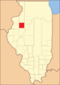
Putnam County is the least extensive county in the U.S. state of Illinois. According to the 2020 census, it had a population of 5,637. The county seat is Hennepin. The county was formed in 1825 out of Fulton County and named after Israel Putnam, who was a general in the American Revolution. Putnam County is part of the Ottawa, IL Micropolitan Statistical Area.

<span class="mw-page-title-main">Warren County, Illinois</span> County in Illinois, United States

Warren County is a county in the U.S. state of Illinois. According to the 2020 census, it had a population of 16,835. Its county seat is Monmouth.

<span class="mw-page-title-main">Schuyler County, Illinois</span> County in Illinois, United States

Schuyler County is a county in the U.S. state of Illinois. According to the 2020 census, it had a population of 6,902. Its county seat is Rushville.

<span class="mw-page-title-main">Henry County, Illinois</span> County in Illinois, United States

Henry County is a county located in the U.S. state of Illinois. The 2020 United States Census, listed its population at 49,284. Its county seat is Cambridge.

<span class="mw-page-title-main">Fulton County, Illinois</span> County in Illinois, United States

Fulton County is a county in the U.S. state of Illinois. According to the 2020 census, it had a population of 33,609. Its county seat is Lewistown, and the largest city is Canton. Fulton County comprises the Canton, IL Micropolitan Statistical Area, which is part of the Peoria-Canton, IL Combined Statistical Area.

<span class="mw-page-title-main">Avon, Illinois</span> Village in Illinois, United States

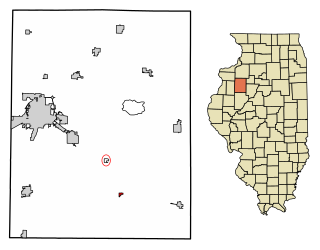
Avon is a village in Fulton County, Illinois, United States. The population was 704 at the 2020 census.

<span class="mw-page-title-main">Fairview, Illinois</span> Village in Illinois, United States

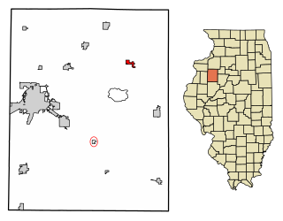
Fairview is a village in Fulton County, Illinois, United States. The population was 426 at the 2020 census.

<span class="mw-page-title-main">London Mills, Illinois</span> Village in Illinois, United States

London Mills is a village in Fulton and Knox counties in the U.S. state of Illinois. The population was 350 at the 2020 census.

<span class="mw-page-title-main">Abingdon, Illinois</span> City in Illinois, United States

Abingdon is a city in Knox County, Illinois, United States, 50 miles (80 km) west of Peoria. It is part of the Galesburg Micropolitan Statistical Area. The city was first settled in 1828 and was incorporated in 1857. In june of 1907, the patent for the common spring-loaded mousetrap was awarded to William Hooker William Armstrong and Knox Mark of Abingdon. The population was 3,319 at the 2010 census, down from 3,612 at the 2000 census.

<span class="mw-page-title-main">Altona, Illinois</span> Village in Illinois, United States

Altona is a village in Knox County, Illinois, United States. The population was 531 at the 2010 census, down from 570 in 2000. It is part of the Galesburg Micropolitan Statistical Area.

<span class="mw-page-title-main">East Galesburg, Illinois</span> Village in Illinois, United States

East Galesburg is a village in Knox County, Illinois, United States. The population was 812 as of the 2010 census, down from 839 in 2000. It is part of the Galesburg Micropolitan Statistical Area.

<span class="mw-page-title-main">Galesburg, Illinois</span> City in Illinois, United States

Galesburg is a city in Knox County, Illinois, United States. The city is 45 miles (72 km) northwest of Peoria. At the 2010 census, its population was 32,195. It is the county seat of Knox County and the principal city of the Galesburg Micropolitan Statistical Area, which includes all of Knox and Warren counties.

<span class="mw-page-title-main">Henderson, Illinois</span> Village in Illinois, United States

Henderson is a village in Knox County, Illinois, United States. The population was 255 at the 2010 census, down from 319 at the 2000 census. It is part of the Galesburg Micropolitan Statistical Area.

<span class="mw-page-title-main">Knoxville, Illinois</span> City in Illinois, United States

Knoxville is a city in Knox County, Illinois, United States. The population was 2,911 at the 2010 census. It is part of the Galesburg Micropolitan Statistical Area.

<span class="mw-page-title-main">Maquon, Illinois</span> American village

Maquon is a village in Knox County, Illinois, United States. The population was 218 at the 2020 census. It is part of the Galesburg Micropolitan Statistical Area.

<span class="mw-page-title-main">St. Augustine, Illinois</span> Village in Illinois, United States

St. Augustine or Saint Augustine is a village in Knox County, Illinois, United States. The population was 120 at the 2010 census, down from 152 at the 2000 census. It is part of the Galesburg Micropolitan Statistical Area.

<span class="mw-page-title-main">Victoria, Illinois</span> Village in Illinois, United States

Victoria is a village in Knox County, Illinois, United States. The population was 316 at the 2010 census. It is part of the Galesburg Micropolitan Statistical Area.

<span class="mw-page-title-main">Williamsfield, Illinois</span> Village in Illinois, United States

Williamsfield is a village in Knox County, Illinois, United States. The population was 578 at the 2010 census. It is part of the Galesburg Micropolitan Statistical Area.

<span class="mw-page-title-main">Yates City, Illinois</span> Village in Illinois, United States

Yates City is a village in Knox County, Illinois, United States. The population was 642 at the 2020 census. It is part of the Galesburg Micropolitan Statistical Area.

<span class="mw-page-title-main">Galesburg, Illinois, micropolitan area</span> Micropolitan Statistical Area in Illinois, United States

The Galesburg, IL Micropolitan Statistical Area, as defined by the United States Census Bureau, is an area consisting of two counties in west central Illinois, anchored by the city of Galesburg.

References

  1. 1 2 "State & County QuickFacts". United States Census Bureau. Archived from the original on June 6, 2011. Retrieved July 6, 2014.
  2. "Find a County". National Association of Counties. Archived from the original on May 31, 2011. Retrieved June 7, 2011.
  3. Gannett, Henry (1905). The Origin of Certain Place Names in the United States. Government Printing Office. pp.  177.
  4. 1 2 "Population, Housing Units, Area, and Density: 2010 - County". United States Census Bureau. Archived from the original on February 12, 2020. Retrieved July 12, 2015.
  5. 1 2 "Monthly Averages for Galesburg, Illinois". The Weather Channel. Retrieved January 27, 2011.
  6. "Annual Estimates of the Resident Population for Counties: April 1, 2020 to July 1, 2023". United States Census Bureau. Retrieved April 2, 2024.
  7. "U.S. Decennial Census". United States Census Bureau. Retrieved July 6, 2014.
  8. "Historical Census Browser". University of Virginia Library. Retrieved July 6, 2014.
  9. "Population of Counties by Decennial Census: 1900 to 1990". United States Census Bureau. Retrieved July 6, 2014.
  10. "Census 2000 PHC-T-4. Ranking Tables for Counties: 1990 and 2000" (PDF). United States Census Bureau. Archived (PDF) from the original on March 27, 2010. Retrieved July 6, 2014.
  11. 1 2 3 "DP-1 Profile of General Population and Housing Characteristics: 2010 Demographic Profile Data". United States Census Bureau. Archived from the original on February 13, 2020. Retrieved July 12, 2015.
  12. "DP02 SELECTED SOCIAL CHARACTERISTICS IN THE UNITED STATES – 2006-2010 American Community Survey 5-Year Estimates". United States Census Bureau. Archived from the original on February 13, 2020. Retrieved July 12, 2015.
  13. "DP03 SELECTED ECONOMIC CHARACTERISTICS – 2006-2010 American Community Survey 5-Year Estimates". United States Census Bureau. Archived from the original on February 13, 2020. Retrieved July 12, 2015.
  14. Leip, David. "Dave Leip's Atlas of U.S. Presidential Elections". uselectionatlas.org. Retrieved March 19, 2018.

Further reading

40°56′N90°13′W / 40.93°N 90.21°W / 40.93; -90.21