Wataga, Illinois

Last updated

Wataga
Village
Wataga, Illinois.jpg
Depot Road in Wataga
Motto(s): 
Just a small town, living in a lonely world.
Knox County Illinois Incorporated and Unincorporated areas Wataga Highlighted.svg
Location of Wataga in Knox County, Illinois
Illinois in United States (US48).svg
Location of Illinois in the United States
Coordinates: 41°01′31″N90°16′32″W / 41.02528°N 90.27556°W / 41.02528; -90.27556 [1]
CountryUnited States
StateIllinois
County Knox
Township Sparta
Area
[2]
  Total0.83 sq mi (2.15 km2)
  Land0.83 sq mi (2.15 km2)
  Water0.00 sq mi (0.00 km2)
Elevation
[1]
830 ft (250 m)
Population
 (2020)
  Total744
  Density897.47/sq mi (346.50/km2)
Time zone UTC-6 (CST)
  Summer (DST) UTC-5 (CDT)
ZIP Code(s)
61488
Area code 309
FIPS code 17-79124
GNIS feature ID2400101 [1]
Wikimedia CommonsWataga, Illinois

Wataga is a village in Knox County, Illinois, United States. The population was 843 at the 2010 census, down from 857 in 2000. It is part of the Galesburg Micropolitan Statistical Area.

Contents

Geography

According to the 2010 census, Wataga has a total area of 0.86 square miles (2.23 km2), all land. [3]

Demographics

Historical population
CensusPop.Note
1860 1,538
1870 1,205−21.7%
1880 734−39.1%
1890 586−20.2%
1900 545−7.0%
1910 444−18.5%
1920 4593.4%
1930 4876.1%
1940 54010.9%
1950 5501.9%
1960 5703.6%
1970 5700.0%
1980 99674.7%
1990 879−11.7%
2000 857−2.5%
2010 843−1.6%
2020 744−11.7%
U.S. Decennial Census [4]

As of the census [5] of 2000, there were 857 people, 336 households, and 256 families residing in the village. The population density was 989.5 inhabitants per square mile (382.0/km2). There were 370 housing units at an average density of 427.2 per square mile (164.9/km2). The racial makeup of the village was 98.13% White, 0.35% African American, 0.12% Asian, 0.12% from other races, and 1.28% from two or more races. Hispanic or Latino of any race were 1.28% of the population.

There were 336 households, out of which 37.5% had children under the age of 18 living with them, 56.5% were married couples living together, 15.8% had a female householder with no husband present, and 23.8% were non-families. 20.2% of all households were made up of individuals, and 8.3% had someone living alone who was 65 years of age or older. The average household size was 2.55 and the average family size was 2.89.

In the village, the population was spread out, with 27.4% under the age of 18, 9.3% from 18 to 24, 27.1% from 25 to 44, 24.9% from 45 to 64, and 11.3% who were 65 years of age or older. The median age was 36 years. For every 100 females, there were 87.5 males. For every 100 females age 18 and over, there were 83.5 males.

The median income for a household in the village was $39,205, and the median income for a family was $41,786. Males had a median income of $35,114 versus $20,700 for females. The per capita income for the village was $15,553. About 8.8% of families and 11.2% of the population were below the poverty line, including 17.5% of those under age 18 and 9.5% of those age 65 or over.

Related Research Articles

<span class="mw-page-title-main">Victoria, Illinois</span> Village in Illinois, United States

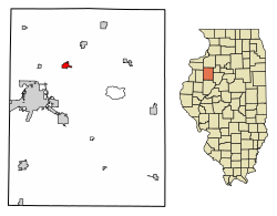
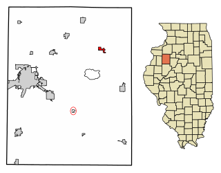
Victoria is a village in Knox County, Illinois, United States. The population was 316 at the 2010 census. It is part of the Galesburg Micropolitan Statistical Area.

<span class="mw-page-title-main">Harrison, Michigan</span> City in Michigan, United States

Harrison is a city in and county seat of Clare County in the U.S. state of Michigan. The population was 2,150 at the 2020 census.

<span class="mw-page-title-main">Elkton, Michigan</span> Village in Michigan, United States

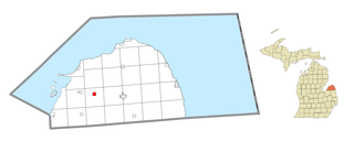
Elkton is a village in Huron County in the U.S. state of Michigan. The population was 796 at the 2020 census. The village is within Oliver Township, along the Pinnebog River. It was incorporated in 1897.

<span class="mw-page-title-main">Battlefield, Missouri</span> City in Missouri, United States

Battlefield is a city in Greene County, Missouri, United States. As of the 2020 census, the city's population was 5,990. It is part of the Springfield, Missouri Metropolitan Statistical Area. The town has no post office and shares the ZIP code (65619) with Brookline.

<span class="mw-page-title-main">Leawood, Missouri</span> Village in Missouri, United States

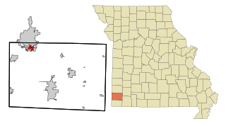
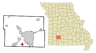
Leawood is a village in Newton County, Missouri, United States. The population was 682 at the 2010 census. It is part of the Joplin, Missouri Metropolitan Statistical Area.

<span class="mw-page-title-main">Clyde, Missouri</span> Village in Missouri, United States

Clyde is a village in eastern Nodaway County, Missouri, United States. The population was 82 at the 2010 census.

<span class="mw-page-title-main">Rayville, Missouri</span> Census-designated place in Missouri, United States

Rayville is a census-designated place and former village in Ray County, Missouri, and part of the Kansas City metropolitan area within the United States. The population was 157 at the 2020 census. It disincorporated in 2012.

<span class="mw-page-title-main">Roseland, Nebraska</span> Village in Nebraska, United States

Roseland is a village in Adams County, Nebraska, United States. The population was 260 at the 2020 census. It is part of the Hastings, Nebraska Micropolitan Statistical Area.

<span class="mw-page-title-main">Platte Center, Nebraska</span> Village in Platte County, Nebraska, United States

Platte Center is a village in Platte County, Nebraska, United States. The population was 336 at the 2010 census.

<span class="mw-page-title-main">Malmo, Nebraska</span> Village in Saunders County, Nebraska, United States

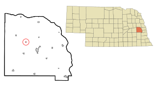
Malmo is a village in Saunders County, Nebraska, United States. The population was 94 at the 2020 census.

<span class="mw-page-title-main">Polk, Ohio</span> Village in Ohio, United States

Polk is a village in Ashland County, Ohio, United States. The population was 310 at the 2020 census.

<span class="mw-page-title-main">North Bend, Ohio</span> Village in Ohio, United States

North Bend is a village in Miami Township, Hamilton County, Ohio, United States, along the Ohio River. It is a part of the Greater Cincinnati area. The population was 835 at the 2020 census.

<span class="mw-page-title-main">Nashville, Ohio</span> Village in Ohio, United States

Nashville is a village in Holmes County, Ohio, United States. The population was 183 at the 2020 census.

<span class="mw-page-title-main">Coalton, Ohio</span> Village in Ohio, United States

Coalton is a village in Jackson County, Ohio, United States. The population was 445 at the 2020 census.

<span class="mw-page-title-main">North Perry, Ohio</span> Village in Ohio, United States

North Perry is a village in Lake County, Ohio, United States. The population was 915 at the 2020 census.

<span class="mw-page-title-main">Covington, Ohio</span> Village in Ohio, United States

Covington is a village in Miami County, Ohio, United States. The population was 2,548 at the 2020 census. It is part of the Dayton Metropolitan Statistical Area. The village was incorporated as Covington in 1835 on the site of the 1793 Fort Rowdy.

<span class="mw-page-title-main">Brandon, Wisconsin</span> Village in Wisconsin, United States

Brandon is a village in Fond du Lac County, Wisconsin, United States. The population was 879 at the 2010 census.

<span class="mw-page-title-main">Dorchester, Wisconsin</span> Village in Wisconsin, United States

Dorchester is a village in Clark and Marathon counties in the U.S. state of Wisconsin, along the 45th parallel. It is part of the Wausau, Wisconsin Metropolitan Statistical Area. The population was 876 at the 2010 census. Of this, 871 were in Clark County, and only 5 were in Marathon County.

<span class="mw-page-title-main">Casco, Wisconsin</span> Village in Wisconsin, United States

Casco is a village in Kewaunee County, Wisconsin, United States. The population was 583 at the 2010 census. It is part of the Green Bay Metropolitan Statistical Area. The village is located within the Town of Casco. Casco is named after Casco Bay on the coast of Maine, the previous home of Edward Decker, an early logger in Kewaunee County.

Milltown is a town in Polk County, Wisconsin, United States. The population was 1,146 at the 2000 census. The village of Milltown is located within the town.

References

  1. 1 2 3 U.S. Geological Survey Geographic Names Information System: Wataga, Illinois
  2. "2020 U.S. Gazetteer Files". United States Census Bureau. Retrieved March 15, 2022.
  3. "G001 - Geographic Identifiers - 2010 Census Summary File 1". United States Census Bureau. Archived from the original on February 13, 2020. Retrieved December 25, 2015.
  4. "Census of Population and Housing". Census.gov. Retrieved June 4, 2015.
  5. "U.S. Census website". United States Census Bureau . Retrieved January 31, 2008.