Northwest Indiana

Last updated

Northwest Indiana, nicknamed The Region after the Calumet Region, [1] comprises Lake, Porter, LaPorte, and Newton counties in Indiana.[ citation needed ] This region neighbors Lake Michigan and is part of the Chicago metropolitan area. According to the 2020 Census, Northwest Indiana has a population of 831,080 and is the state's second largest urban area after the Indianapolis Metropolitan Area. It is also the home of the Indiana Dunes, parts of which have been preserved through conservation efforts. [2] [3] [4] The town of Ogden Dunes houses the Hour Glass, a museum showcasing the ecological and conservation efforts of O. D. Frank. [4]

Contents

The region's largest city is Hammond, followed closely by Gary. Other municipalities in Northwest Indiana include Burns Harbor, Chesterton, Crown Point, DeMotte, Dyer, East Chicago, Griffith, Highland, Hebron, Hobart, Kentland, Lake Station, La Porte, Lowell, Merrillville, Michigan City, Munster, Portage, Schererville, St. John, Cedar Lake, Valparaiso, Whiting, and Winfield.

Overview

The counties of Lake, LaPorte, Newton and Porter are included in the Chicago-Naperville-Michigan City Combined Statistical Area, the broadest of the census-derived Metropolitan definitions. Unlike the majority of Indiana, which operates on Eastern Standard Time, these counties are among six in Northern Indiana that are in the Central Time Zone (the others being Jasper and Starke). This reflects their close economic integration in the Chicago metropolitan area.

Three counties Lake, Porter and LaPorte are served by the Northwestern Indiana Regional Planning Commission metropolitan planning organization. [5] Northwest Indiana is the home of Marktown, Clayton Mark's planned worker community. [6]

Geography

The Long Stairs up the dune at West Beach on the Succession Trail West Beach Succession Trail Dune.JPG
The Long Stairs up the dune at West Beach on the Succession Trail

The Lake Michigan shore is a major attraction. Indiana Dunes National Park, which stretches from Gary to Michigan City, is a well-preserved stretch of sand dunes, beaches, grasslands, and forests, as well as several historical homes and buildings.

The terrain of Northwest Indiana varies from very steep and rugged at the dunes, to rolling in the moraines, and to pancake flat in the river valleys. It was shaped by glacial activity and Lake Michigan. The main geographical features of Northwest Indiana include the Valparaiso Moraine, Tinley Moraine, Lake Border Moraine, Iroquois Moraine, Calumet Shoreline, Glenwood Shoreline, Tolleston shorelines, and the Kankakee Outwash Plain. [7]

Chicago Lake Plain

The Chicago Lake Plain covers the relatively flat northern quarter of Northwest Indiana north of the moraines. Initially, the plain was flat, composed of glacio-lacustrine deposits. These formed under the waters of glacial Lake Michigan. The lake formed from the melting glaciers north of the Valparaiso Moraine. Eventually the lake overflowed a low spot on the moraine at the Chicago Outlet near the southwest suburbs. This lowered the lake level to current day Lake Michigan levels (Horsley, 1986). [8] As the lake shrunk, it left a series of sand ridges where its ancient beaches were. Along the Lake Michigan shoreline, the prevailing winds have built a series of dune ridges, breaking up the original flat surface of the Lake Plain.

Wheaton Morainal Plain

Physiography of the Upper Illinois River Basin Kankakee Physiography modified.JPG
Physiography of the Upper Illinois River Basin

South of the Chicago Lake Plain in the central parts of Lake and Porter County and northern LaPorte county is the hilly Wheaton Morainal Plain. The Wheaton Morainal Plain consist of the Valparaiso Moraine and Tinley Moraine, paralleling the Lake Michigan Shoreline. The plain consist of rolling Wisconsinan-age moraines. The Morainal Plain is clayey till, and sandy and loamy till, with areas of sand and gravel. Other deposits include lake clay, silt, and alluvium. Deposits are between 50 and 200 ft thick, with many southern areas have over 200 ft of till (Mades, 1987). [9]

Kankakee Outwash Plain

The Kankakee Outwash Plain (southern Lake, Porter, and LaPorte counties) is a flat outwash plain formed by the melting glacier, which was stopped at the Valparaiso Moraine. (Mickelson and others, 1984). Deposits are predominantly sand and gravel, but also include alluvium and fill materials. Deposits average less than 200 ft thick; in the lowlands they can be less than 50 ft thick, while in the upland they can be more than 200 ft thick. Local elevation changes are less than 100 ft. [9] and include many scattered sand dunes.

Bloomington Ridged Plain

The Bloomington Ridged Plain covers only the most southern part of Northwest Indiana in the valley of the Iroquois River in southern Newton and Jasper counties. This area consists of low and rolling hills, i.e., moraines like the Iroquois Moraine with less than 300 ft changes in elevation. The soils are loamy till, lake clay and silt. Unlike the northern half of Northwest Indiana, the Huron-Erie glacial lobe left these deposits in its northeastward retreat. Deposits are less than 200 ft thick, with some more than 400 feet thick. [10]

Economy

With a gross domestic product of $28.64 billion in 2015, Northwest Indiana accounts for approximately nine percent of Indiana's gross state product. This figure ranks second among metropolitan areas in the state (after Indianapolis) and 89th in the United States, comparable to the GDP of the El Paso, Texas metropolitan area. [11]

The northern portion of Northwest Indiana is noted for its heavy industry. Gary, Portage, Burns Harbor and East Chicago are home to major steel mills, including the largest North American facilities for both U.S. Steel (Gary Works) and Cleveland Cliffs (Indiana Harbor). Whiting and Hammond are home to the largest oil refinery in the Midwestern U.S., operated by BP. Other industrial outputs include fabricated metals, transportation equipment, and food products.

Since the 1990s, casino gambling has become a significant component of Northwest Indiana's economy. A land-based casino with about 150,000 square feet (14,000 m2) of gambling floor opened in Gary in 2021, replacing two boats. Two casino boat properties with approximately 164,000 square feet (15,200 m2) of aggregate gaming space are located along Lake Michigan in Lake County. An additional 65,000 square feet (6,000 m2) of gaming space is located in Michigan City. [12]

Former Indiana Governor Mitch Daniels and the Indiana State Legislature formed the entity known as the Northwest Indiana Regional Development Authority (RDA) in 2006. [13] The RDA, a special-purpose district, is vested with both legal authority and tax dollars to invest in transportation and economic development throughout the region.

A number of Northwest Indiana's suburban communities serve as bedroom communities for Chicago.

Education

Colleges and universities located in Northwest Indiana include:

These institutions offer a variety of degree programs in fields such as business administration, engineering and engineering technology, law, education, computing and information technology, and the liberal arts. Additionally, Northwest Indiana is proximate to numerous other universities elsewhere in Indiana and in the Chicago metropolitan area. [14]

A number of both public and private primary and secondary schools are also located throughout Northwest Indiana and the nearby Chicago metropolitan area.

Counties

Census Bureau population statistics

Census Area 2020 Census 2010 Census 2000 Census 1990 Census 1980 Census 1970 Census 1960 Census 1950 Census
Lake County, Indiana
498,700
496,005
484,564
475,594
522,965
546,253
513,269
368,152
LaPorte County, Indiana
112,417
111,467
110,106
107,066
108,632
105,342
95,111
76,808
Newton County, Indiana
13,830
14,244
14,566
13,551
14,844
11,606
11,502
11,006
Porter County, Indiana
173,215
164,343
146,798
128,932
119,816
87,114
60,279
40,076
Total
831,080
819,537
786,077
750,103
792,395
770,744
699,003
513,073

Transportation

Major airports

Commuter rail

South Shore Train at Dune Park Station South Shore Train at Dunes Park.jpg
South Shore Train at Dune Park Station

Highways

Area codes

Local media

Online

Print

Broadcast

Notable people

Parks and nature areas

Related Research Articles

<span class="mw-page-title-main">Porter County, Indiana</span> County in Indiana, United States

Porter County is a county in the U.S. state of Indiana. As of 2020, the population was 173,215, making it the 10th most populous county in Indiana. The county seat is Valparaiso. The county is part of Northwest Indiana, as well as the Chicago metropolitan area. Porter County is the site of much of the Indiana Dunes, an area of ecological significance. The Hour Glass Museum in Ogden Dunes documents the region's ecological significance.

<span class="mw-page-title-main">Lake County, Indiana</span> County in Indiana, United States

Lake County is a county located in the U.S. state of Indiana. In 2020, its population was 498,700, making it Indiana's second-most populous county. The county seat is Crown Point. The county is part of Northwest Indiana and the Chicago metropolitan area, and contains a mix of urban, suburban and rural areas. It is bordered on the north by Lake Michigan and contains a portion of the Indiana Dunes. It includes Marktown, Clayton Mark's planned worker community in East Chicago.

<span class="mw-page-title-main">Calumet River</span> System of rivers and canals in Illinois and Indiana, United States

The Calumet River is a system of heavily industrialized rivers and canals in the region between the south side of Chicago, Illinois, and the city of Gary, Indiana. Historically, the Little Calumet River and the Grand Calumet River were one, the former flowing west from Indiana into Illinois, then turning back east to its mouth at Lake Michigan at Marquette Park in Gary. Now the system is part of the Chicago Area Waterway System and through the use of locks flows away from Lake Michigan to the Cal-Sag Channel.

<span class="mw-page-title-main">Watersheds of Indiana</span>

The Watersheds of Indiana consist of six distinct Indiana watershed regions that drain into five major bodies of water.

<span class="mw-page-title-main">Indiana Dunes National Park</span> United States National Park in Indiana

Indiana Dunes National Park is a United States national park located in northwestern Indiana managed by the National Park Service. It was authorized by Congress in 1966 as the Indiana Dunes National Lakeshore and was redesignated as the nation's 61st national park on February 15, 2019. The park runs for about 20 miles (32 km) along the southern shore of Lake Michigan and covers 15,349 acres (6,212 ha). Along the lakefront, the eastern area is roughly the lake shore south to U.S. 12 or U.S. 20 between Michigan City, Indiana, on the east and the Cleveland-Cliffs steel plant on the west. This area's conservation scheme is enhanced by the older Indiana Dunes State Park. To the west of the steel plant lies West Beach and a small extension south of the steel mill continues west along Salt Creek to Indiana 249. The western area is roughly the shoreline south to U.S. 12 between the Burns Ditch west to Broadway in downtown Gary, Indiana. In addition, there are several outlying areas, including Pinhook Bog, in LaPorte County to the east; the Heron Rookery in Porter County, the center of the park; and the Calumet Prairie State Nature Preserve and the Hobart Prairie Grove, both in Lake County, the western end of the park.

<span class="mw-page-title-main">Kankakee River</span> River in Indiana and Illinois, United States

The Kankakee River is a tributary of the Illinois River, approximately 133 miles (214 km) long, in the Central Corn Belt Plains of northwestern Indiana and northeastern Illinois in the United States. At one time, the river drained one of the largest wetlands in North America and furnished a significant portage between the Great Lakes and the Mississippi River. Significantly altered from its original channel, it flows through a primarily rural farming region of reclaimed cropland, south of Lake Michigan.

The Calumet Region is the geographic area drained by the Grand Calumet River and the Little Calumet River of northeastern Illinois and northwestern Indiana in the United States. It is part of the Great Lakes Basin, which eventually reaches the Atlantic Ocean. It is a sub-region of the greater Northwest Indiana region and the even larger Great Lakes region.

<span class="mw-page-title-main">Lake Chicago</span> Prehistoric lake from the Wisconsin Glacial Period

Lake Chicago was a prehistoric proglacial lake that is the ancestor of what is now known as Lake Michigan, one of North America's five Great Lakes. Formed about 13,000 years ago and fed by retreating glaciers, it drained south through the Chicago Outlet River.

<span class="mw-page-title-main">Northern Indiana</span> Geographic and cultural region of Indiana, United States

Northern Indiana is a geographic and cultural region that generally comprises the northern third of the U.S. state of Indiana and borders the states of Illinois to the west, Michigan to the north, and Ohio to the east. Spanning the state's northernmost 26 counties, its main population centers include Northwest Indiana, Michiana, and the Fort Wayne metropolitan area.

<span class="mw-page-title-main">Geography of Indiana</span> Overview of the geography of Indiana

The geography of Indiana comprises the physical features of the land and relative location of U.S. State of Indiana. Indiana is in the north-central United States and borders on Lake Michigan. Surrounding states are Michigan to the north and northeast, Illinois to the west, Kentucky to the south, and Ohio to the east. The entire southern boundary is the Ohio River.

<span class="mw-page-title-main">Valparaiso Moraine</span> Moraine in the midwestern United States

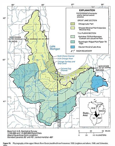
The Valparaiso Moraine is a recessional moraine that forms an immense U around the southern Lake Michigan basin in North America. It is a band of hilly terrain composed of glacial till and sand. The Valparaiso Moraine defines part of the continental divide known as the Saint Lawrence River Divide, bounding the Great Lakes Basin. It begins near the border of Wisconsin and Illinois and extends south through Lake, McHenry, Cook, DuPage and Will counties in Illinois, and then turns southeast, going through northwestern Indiana. From this point, the moraine curves northeast through Lake, Porter, and LaPorte counties of Indiana into Michigan. It continues into Michigan as far as Montcalm County.

<span class="mw-page-title-main">Kankakee Outwash Plain</span>

The Kankakee Outwash Plain is a flat plain interspersed with sand dunes in the Kankakee River valley in northwestern Indiana and northeastern Illinois of the United States. It is just south of the Valparaiso Moraine and was formed during the Wisconsin Glaciation. As the glacier stopped at the Valparaiso Moraine, its meltwater was carried away to the outwash plain. On the south side of the moraine, where the elevation drops, the meltwaters eroded away valleys, carrying sand and mud with them. As the muddy meltwater reached the valley where the slope lessened, the water slowed, depositing the sand on the outwash plain. This created a smooth, flat, and sandy plain. Before its draining, the Kankakee Marsh, located on the outwash plain, was one of the largest freshwater marshes in the United States.

<span class="mw-page-title-main">Glenwood Shoreline</span>

The Glenwood Shoreline is an ancient shoreline of the precursor to Lake Michigan, Lake Chicago. It is named after the town of Glenwood, Illinois. The shoreline was formed when the lake was higher during the last ice age, while ice blocked the Straits of Mackinac. After the straits were freed, the lake receded and left behind a sand ridge at an elevation of about 640 feet (200 m) where the shore resided. This ridge can be seen clearly in Glenwood, Illinois, Dyer, Indiana, and Schererville, Indiana, all south of Chicago.

The Indiana Dunes are natural sand dunes occurring at the southern end of Lake Michigan in the American State of Indiana. They are known for their ecological significance. Many conservationists have played a role in preserving parts of the Indiana Dunes. The Hour Glass, a museum in Ogden Dunes, showcases some of the ecological import of the Dunes.

<span class="mw-page-title-main">Habitats of the Indiana Dunes</span> Set of habitats in the United States

The Indiana Dunes comprise ten different habitats. Each provides for a unique combination of plants and animals. The range of the Indiana Dunes varies depending your source. The Indiana Lake Michigan Coastal Program uses the river drainage systems along the shoreline. This expands the area from the areas of lakeshore southward to the edges of the Valparaiso Moraine. This entire region has been dune landscapes since over 114,000 years before present (YBP). Traditionally, the Indiana Dunes area thought of as a narrow area along the shores of Lake Michigan, including the areas of Marquette Park in Gary, Indiana (1920), Indiana Dunes State Park (1926) and Indiana Dunes National Park,. The identified ten habitats can be found in these parks, where they have been preserved, but are also visible throughout the three counties of Northwest Indiana.

<span class="mw-page-title-main">East Arm Little Calumet River</span> River in Indiana, United States

The East Arm Little Calumet River, also known as the Little Calumet River East Branch, is a 22.1-mile-long (35.6 km) portion of the Little Calumet River that begins just east of Holmesville, Indiana in New Durham Township in LaPorte County and flows west to Porter County and the Port of Indiana-Burns Waterway.

<span class="mw-page-title-main">Salt Creek (Little Calumet River tributary)</span> River in Indiana, United States

Salt Creek is a 24.0-mile-long (38.6 km) tributary of the East Arm Little Calumet River that begins south of Valparaiso in Porter County, Indiana and flows north until it joins the East Arm Little Calumet River just before it exits to Lake Michigan via the Port of Indiana-Burns Waterway.

The Shirley Heinze Land Trust, originally known as the Shirley Heinze Environmental Fund, is a 501(c)(3) nonprofit land trust dedicated to the preservation of natural areas in Northwest Indiana. The Heinze Trust manages more than 2,800 acres of protected land in Lake, Porter, LaPorte, St. Joseph, Starke, and Marshall Counties in Indiana. Its preserves include a wide range of dune, wetland, prairie, and forest ecosystems.

<span class="mw-page-title-main">Lake Kankakee</span>

Lake Kankakee formed 14,000 years before present (YBP) in the valley of the Kankakee River. It developed from the outwash of the Michigan Lobe, Saginaw Lobe, and the Huron-Erie Lobe of the Wisconsin glaciation. These three ice sheets formed a basin across Northwestern Indiana. It was a time when the glaciers were receding, but had stopped for a thousand years in these locations. The lake drained about 13,000 YBP, until reaching the level of the Momence Ledge. The outcropping of limestone created an artificial base level, holding water throughout the upper basin, creating the Grand Kankakee Marsh.

The Calumet Aquifer is an aquifer underlying the land at the extreme southern tip of Lake Michigan. It underlies the northern third of Lake County, Indiana and the northern tenth of Porter County, as well as small parts of LaPorte County and Cook County, Illinois. It is notable chiefly for its high levels of contamination by industrial waste from factories and toxic waste dumps in the Calumet Region. It is bordered to the south by Valparaiso Moraine Aquifer, and to the north by Lake Michigan. It is underlain by a Silurian bedrock aquifer complex.

References

  1. "What's up with that? Where did the term 'Da Region' come from?".
  2. "South Shore Journal - Alice Gray, Dorothy Buell, and Naomi Svihla: Preservationists of Ogden Dunes". Archived from the original on 2012-09-13. Retrieved 2012-06-11.
  3. "South Shore Journal - the Historical Roots of the Nature Conservancy in the Northwest Indiana/Chicagoland Region: From Science to Preservation". Archived from the original on 2016-01-01. Retrieved 2015-11-22.
  4. 1 2 "South Shore Journal - the Cultural Impact of a Museum in a Small Community: The Hour Glass in Ogden Dunes". Archived from the original on 2012-11-30. Retrieved 2012-06-11.
  5. "Northwestern Indiana Regional Planning Commission Homepage". Nirpc.org. Retrieved 2015-07-26.
  6. "South Shore Journal - Marktown: Clayton Mark's Planned Worker Community in Northwest Indiana". Archived from the original on 2012-09-13. Retrieved 2012-08-29.
  7. Environmental Geology of Lake and Porter Counties, Indiana An Aid to Planning; By Edwin J. Hartke, John R. Hill, and Mark Reshkin; Environmental Study 8 Department of Natural Resources Geological Survey Special Report 11
  8. Environmental Setting of the Upper Illinois River Basin and Implications for Water Quality Water-Resources Investigations Report 98–4268; Terri L. Arnold, Daniel J. Sullivan, Mitchell A. Harris, Faith A. Fitzpatrick, Barbara C. Scudder, Peter M. Ruhl, Dorothea W. Hanchar, and Jana S. Stewart; U.S. Geologic Survey, Department of the Interior; Urbana, Illinois; 1999; pg 11
  9. 1 2 pg 12
  10. pg 12, 18
  11. "Northwest Indiana has state's second biggest economy". Indianeconomicdigest.com. Retrieved July 3, 2016.
  12. "South Shore Casinos | Northwest Indiana Things to Do". Southshorecva.com. Retrieved 2016-07-26.
  13. Mike Pence (2016-07-21). "RDA: Home". In.gov. Retrieved 2016-07-26.
  14. ""America's Best Colleges 2007"". U.S. News & World Report. Archived from the original on 2007-01-11. Retrieved 2006-11-25.
  15. "The Lakeshore 89.1 FM Homepage". Thelakeshorefm.com. Retrieved 2015-07-26.
  16. 1 2 3 4 Streets of Northwest Indiana; Rand McNally, Chicago, Illinois, 2008
  17. 1 2 3 4 Indiana Atlas and Gazetter; DeLorme, Yarmouth, Vermont

41°10′N87°0′W / 41.167°N 87.000°W / 41.167; -87.000