Union County, Indiana

Last updated

Union County
Union County Courthouse, Liberty, IN (48490910786).jpg
Union County Courthouse in Liberty
Map of Indiana highlighting Union County.svg
Location within the U.S. state of Indiana
Indiana in United States.svg
Indiana's location within the U.S.
Coordinates: 39°37′N84°55′W / 39.62°N 84.92°W / 39.62; -84.92
CountryFlag of the United States.svg United States
StateFlag of Indiana.svg  Indiana
FoundedJanuary 5, 1821 (created)
February 1, 1821 (organized)
Seat Liberty
Largest townLiberty
Area
  Total165.18 sq mi (427.8 km2)
  Land161.22 sq mi (417.6 km2)
  Water3.95 sq mi (10.2 km2)  2.39%
Population
 (2020)
  Total7,087
  Density43.6/sq mi (16.8/km2)
Time zone UTC−5 (Eastern)
  Summer (DST) UTC−4 (EDT)
Congressional district 6th
Website www.unioncountyin.gov
Indiana county number 81

Union County is a county in the U.S. state of Indiana. As of the 2020 United States census, the population was 7,087. [1] The county seat is Liberty. [2]

Contents

Since 2018, Union County has been included in the Cincinnati-Middletown, OH-KY-IN Metropolitan Statistical Area. It is located on the Indiana-Ohio border.

History

The future state of Indiana was first regulated by passage of the Northwest Ordinance in 1787. In 1790 the Territory was divided into two counties, with Knox covering much of present-day Indiana. In 1810, a portion of Knox was partitioned to create Wayne County; in 1811 a portion further south was partitioned to create Franklin. The area between those two counties was partitioned in 1818 to create Fayette; by the 1820s the eastern part of Fayette County was populated sufficiently to warrant separate representation. Thus on January 5, 1821, the state legislature authorized the creation of Union County, with areas ceded from Wayne County, Fayette County and Franklin County. The organization of the new county's governing structure began on February 1, 1821. [3]

Liberty from the air, looking east Liberty-indiana-from-above.jpg
Liberty from the air, looking east

It was so named because it united parts of Fayette, Franklin and Wayne counties. The first settlers were from Laurens District, South Carolina. John Templeton was the first settler to enter land at the Cincinnati land office in what would become Harmony Township, Union County Indiana. The first county seat was Brownsville, a small community on the East Fork of the Whitewater River. The seat was moved in 1824 to Liberty, a central location. The primary industry of Union County was and is farming.

Geography

Union County lies on the east side of Indiana; its east border abuts the state of Ohio. Its low rolling hills have now been cleared of timber, although drainage areas are still largely brush-filled. The area is devoted to agricultural or recreational uses. [4] The highest point on the terrain (1,140 feet/350 meters ASL) is a rise near the county's north border, 1.0 mile (1.6 km) ENE from Witts Station. [5]

Silver Creek flows southwestward through the northeastern part of the county, discharging into Whitewater Lake. The East Fork of Whitewater River flows southward through the upper western part of the county, discharging into Brookville Lake. The lower part of the county is drained by Dubois Creek, flowing westward into Brookville Lake. [4]

According to the 2010 census, the county has a total area of 165.18 square miles (427.8 km2), of which 161.22 square miles (417.6 km2) (or 97.60%) is land and 3.95 square miles (10.2 km2) (or 2.39%) is water. [6]

Adjacent counties

Major highways

Lakes

Protected areas

Quakertown State Recreation Area

Incorporated towns

Unincorporated communities

Townships

Climate and weather

Liberty, Indiana
Climate chart (explanation)
J
F
M
A
M
J
J
A
S
O
N
D
 
 
3
 
 
36
17
 
 
2.7
 
 
42
20
 
 
3.8
 
 
53
29
 
 
4
 
 
64
38
 
 
4.9
 
 
74
48
 
 
4.1
 
 
83
58
 
 
4.3
 
 
87
62
 
 
3.9
 
 
85
60
 
 
2.7
 
 
79
52
 
 
3
 
 
67
40
 
 
3.7
 
 
53
32
 
 
3.3
 
 
41
23
Average max. and min. temperatures in °F
Precipitation totals in inches
Source: The Weather Channel [7]
Metric conversion
J
F
M
A
M
J
J
A
S
O
N
D
 
 
76
 
 
2
−8
 
 
68
 
 
6
−7
 
 
97
 
 
12
−2
 
 
101
 
 
18
3
 
 
124
 
 
23
9
 
 
104
 
 
28
14
 
 
108
 
 
31
17
 
 
99
 
 
29
16
 
 
68
 
 
26
11
 
 
77
 
 
19
4
 
 
93
 
 
12
0
 
 
84
 
 
5
−5
Average max. and min. temperatures in °C
Precipitation totals in mm

In recent years, average temperatures in Liberty have ranged from a low of 17 °F (−8 °C) in January to a high of 87 °F (31 °C) in July, although a record low of −31 °F (−35 °C) was recorded in January 1994 and a record high of 104 °F (40 °C) was recorded in September 1951. Average monthly precipitation ranged from 2.68 inches (68 mm) in September to 4.90 inches (124 mm) in May. [7]

Government

The county government is a constitutional body, and is granted specific powers by the Constitution of Indiana, and by the Indiana Code.

County Council: The legislative branch of the county government; controls spending and revenue collection in the county. Representatives are elected to four-year terms from county districts. They set salaries, the annual budget, and special spending. The council has limited authority to impose local taxes, in the form of an income and property tax that is subject to state level approval, excise taxes, and service taxes. [8] [9]

Board of Commissioners: The executive body of the county. Commissioners are elected county-wide to staggered four-year terms. One commissioner serves as president. The commissioners execute acts legislated by the council, collect revenue, and manage county government. [8] [9]

Court: The county maintains a circuit court that can handle all case types. The judge of the court is elected to a term of six years and must be a member of the Indiana Bar Association. In some cases, court decisions can be appealed to the state level appeals court. [9]

County Officials: The county has other elected offices, including sheriff, coroner, auditor, treasurer, recorder, surveyor, and circuit court clerk. These officers are elected to four-year terms. People elected to county government positions are required to be residents of the county. [9]

United States presidential election results for Union County, Indiana [10]
Year Republican Democratic Third party
No.%No.%No.%
2020 2,68876.98%73621.08%681.95%
2016 2,44573.76%71521.57%1554.68%
2012 2,02265.14%1,01832.80%642.06%
2008 2,06161.43%1,22436.48%702.09%
2004 2,26667.76%1,04531.25%330.99%
2000 1,83864.99%92732.78%632.23%
1996 1,33448.86%1,01937.33%37713.81%
1992 1,39446.97%89830.26%67622.78%
1988 1,81465.49%94634.15%100.36%
1984 1,97070.36%81629.14%140.50%
1980 1,76663.53%89832.30%1164.17%
1976 1,63158.25%1,16041.43%90.32%
1972 2,04372.50%76527.15%100.35%
1968 1,69156.01%92030.47%40813.51%
1964 1,53150.95%1,46348.69%110.37%
1960 2,08763.73%1,18036.03%80.24%
1956 2,02663.47%1,15736.25%90.28%
1952 2,15967.24%1,02932.05%230.72%
1948 1,85963.25%1,04935.69%311.05%
1944 1,99863.05%1,15436.42%170.54%
1940 2,00958.35%1,41541.10%190.55%
1936 1,63049.20%1,66250.17%210.63%
1932 1,65850.41%1,58748.25%441.34%
1928 2,10165.99%1,06933.57%140.44%
1924 1,90758.77%1,28439.57%541.66%
1920 1,98458.30%1,37540.41%441.29%
1916 99752.95%82643.87%603.19%
1912 64335.88%70539.34%44424.78%
1908 1,06654.25%80841.12%914.63%
1904 1,15657.51%75837.71%964.78%
1900 1,06052.68%89744.58%552.73%
1896 1,11854.06%91544.25%351.69%
1892 98151.80%83944.30%743.91%
1888 1,10854.74%86842.89%482.37%

Demographics

Historical population
CensusPop.Note
1830 7,944
1840 8,0170.9%
1850 6,944−13.4%
1860 7,1092.4%
1870 6,341−10.8%
1880 7,67321.0%
1890 7,006−8.7%
1900 6,748−3.7%
1910 6,260−7.2%
1920 6,021−3.8%
1930 5,880−2.3%
1940 6,0172.3%
1950 6,4126.6%
1960 6,4570.7%
1970 6,5821.9%
1980 6,8604.2%
1990 6,9761.7%
2000 7,3495.3%
2010 7,5162.3%
2020 7,087−5.7%
2023 (est.)6,973 [11] −1.6%
US Decennial Census [12]
1790–1960 [13] 1900–1990 [14]
1990–2000 [15] 2010–2013 [1]

2010 Census

As of the 2010 United States Census, there were 7,516 people, 2,938 households, and 2,117 families in the county. [16] The population density was 46.6 inhabitants per square mile (18.0/km2). There were 3,239 housing units at an average density of 20.1 per square mile (7.8/km2). [6] The racial makeup of the county was 97.5% white, 0.4% black or African American, 0.3% Asian, 0.3% American Indian, 0.1% Pacific islander, 0.3% from other races, and 1.1% from two or more races. Those of Hispanic or Latino origin made up 1.1% of the population. [16] In terms of ancestry, 26.2% were German, 16.0% were Irish, 11.9% were English, and 11.6% were American. [17]

Of the 2,938 households, 34.4% had children under the age of 18 living with them, 56.0% were married couples living together, 11.7% had a female householder with no husband present, 27.9% were non-families, and 23.9% of all households were made up of individuals. The average household size was 2.54 and the average family size was 2.99. The median age was 40.3 years. [16]

The median income for a household in the county was $47,697 and the median income for a family was $49,815. Males had a median income of $39,603 versus $27,394 for females. The per capita income for the county was $19,243. About 8.2% of families and 11.9% of the population were below the poverty line, including 21.2% of those under age 18 and 10.0% of those age 65 or over. [18]

Education

All of Union County is served by the Union County–College Corner Joint School District, the only joint state school district in the state. [19]

Notable people

See also

Related Research Articles

<span class="mw-page-title-main">Montgomery County, Ohio</span> County in Ohio, United States

Montgomery County is in the southwestern part of the U.S. state of Ohio. At the 2020 census, the population was 537,309, making it the fifth-most populous county in Ohio. The county seat is Dayton. The county was named in honor of Richard Montgomery, an American Revolutionary War general, who was killed in 1775 while attempting to capture Quebec City, Canada. Montgomery County is part of the Dayton, Ohio, Metropolitan Statistical Area.

<span class="mw-page-title-main">Lamar County, Alabama</span> County in Alabama, United States

Lamar County is a county in the U.S. state of Alabama. As of the 2020 census, the population was 13,972. Its county seat is Vernon and it is a dry county. It is named in honor of Lucius Quintus Cincinnatus Lamar, a former Confederate officer and former member of both houses of the United States Congress from Mississippi.

<span class="mw-page-title-main">Fayette County, Tennessee</span> County in Tennessee, United States

Fayette County is a county located in the U.S. state of Tennessee. As of the 2020 census, the population was 41,990. Its county seat is Somerville. The county was named after the Marquis de la Fayette, French hero of the American Revolution. A part of the Memphis, TN-MS-AR Metropolitan Statistical Area, Fayette County is culturally alike to the Mississippi Delta and was a major area of cotton plantations dependent on slave labor in the nineteenth century.

<span class="mw-page-title-main">Ross County, Ohio</span> County in Ohio, United States

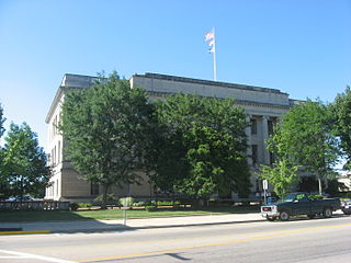
Ross County is a county in the Appalachian region of the U.S. state of Ohio. As of the 2020 United States Census, the population was 77,093. Its county seat is Chillicothe, the first and third capital of Ohio. Established on August 20, 1798, the county is named for Federalist Senator James Ross of Pennsylvania. Ross County comprises the Chillicothe, OH Micropolitan Statistical Area, which is also included in the Columbus-Marion-Zanesville, OH Combined Statistical Area.

<span class="mw-page-title-main">Preble County, Ohio</span> County in Ohio, United States

Preble County is a county located in the U.S. state of Ohio. As of the 2020 census, the population was 40,999, down 3.0% from the 2010 census population of 42,270. Its county seat is Eaton. The county was formed on February 15, 1808, from portions of Butler and Montgomery Counties. It is named for Edward Preble, a naval officer who fought in the American Revolutionary War and against the Barbary Pirates.

<span class="mw-page-title-main">Fayette County, Ohio</span> County in Ohio, United States

Fayette County is a county located in the U.S. state of Ohio. As of the 2020 census, the population was 28,951. Its county seat and largest city is Washington Court House. The county was named for the Marquis de Lafayette, a Frenchman who was an officer in the American Army in the Revolution, when established on March 1, 1810.

<span class="mw-page-title-main">Franklin County, Indiana</span> County in Indiana, United States

Franklin County is a county on the eastern border of the U.S. state of Indiana. In the 2020 United States Census, the county population was 22,785. The county seat is the town of Brookville. Franklin County is part of the Cincinnati, OH–KY–IN Metropolitan Statistical Area. The only incorporated city in Franklin County is Batesville, which lies mostly in adjoining Ripley County.

<span class="mw-page-title-main">Fayette County, Indiana</span> County in Indiana, United States

Fayette County is one of 92 counties in U.S. state of Indiana located in the east central portion of the state. As of 2020, the population was 23,398. Most of the county is rural; land use is farms, pasture and unincorporated woodland. The county seat and only incorporated town is Connersville, which holds a majority of the county's population.

<span class="mw-page-title-main">Lawrenceburg, Indiana</span> City in Indiana, United States

Lawrenceburg is a city and the county seat of Dearborn County, Indiana, United States. The population was 5,129 at the 2020 census. It is the largest city in Dearborn County. Lawrenceburg is in southeast Indiana, on the Ohio River west of Cincinnati.

<span class="mw-page-title-main">Brookville, Indiana</span> Town in Indiana, United States

Brookville is a town in Brookville Township, Franklin County, Indiana, United States. The town is the county seat of and the largest community entirely within Franklin County. The population was 2,596 at the 2010 census.

<span class="mw-page-title-main">Modoc, Indiana</span> Town in Indiana, United States

Modoc is a town in Union Township, Randolph County, in the U.S. state of Indiana. The population was 196 at the 2010 census.

<span class="mw-page-title-main">North Liberty, Indiana</span> Town in Indiana, United States

North Liberty is a town in Liberty Township, St. Joseph County, in the U.S. state of Indiana. The population was 1,896 at the 2010 Census. North Liberty is part of the South Bend–Mishawaka, IN-MI, Metropolitan Statistical Area.

<span class="mw-page-title-main">Harrison, Ohio</span> City in Ohio, United States

Harrison is a city in western Hamilton County, Ohio, United States. The population was 12,563 at the 2020 census. It is part of the Cincinnati metropolitan area.

<span class="mw-page-title-main">Brownsville Township, Pennsylvania</span> Township in Pennsylvania, United States

Brownsville Township is a township in Fayette County, Pennsylvania, United States. The population was 536 at the 2020 census, a decline from the figure of 683 tabulated in 2010. It is served by the Brownsville School District.

<span class="mw-page-title-main">Luzerne Township, Pennsylvania</span> Township in Pennsylvania, United States

Luzerne Township is a township in Fayette County, Pennsylvania, United States. The population was 5,585 at the 2020 census, down from 5,965 at the 2010 census.

<span class="mw-page-title-main">North Union Township, Fayette County, Pennsylvania</span> Township in Pennsylvania, United States

North Union Township is a township in Fayette County, Pennsylvania, United States. The population was 11,829 at the 2020 census, a decline from the figure of 12,728 tabulated in 2010. The Laurel Highlands School District serves the township.

<span class="mw-page-title-main">Redstone Township, Pennsylvania</span> Township in Pennsylvania, United States

Redstone Township is a township in Fayette County, Pennsylvania, United States. The population was 5,077 at the 2020 census, a decline from the figure of 5,566 tabulated in 2010. The Brownsville Area School District serves the region.

<span class="mw-page-title-main">South Union Township, Pennsylvania</span> Township in Pennsylvania, United States

South Union Township is a township in Fayette County, Pennsylvania, United States. The population was 10,897 at the 2020 census, an increase over the figure of 10,681 tabulated in 2010.

<span class="mw-page-title-main">Somerville, Tennessee</span> Town in Tennessee, United States

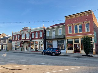
Somerville is a town in Fayette County, Tennessee, United States. It is part of the Memphis metropolitan area. The population was 3,415 at the 2020 census, up from 3,094 at the 2010 census. It is the county seat of Fayette County.

<span class="mw-page-title-main">Liberty Township, Union County, Indiana</span> Township in Indiana, United States

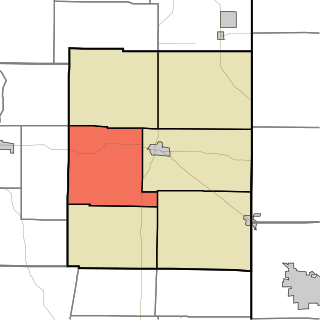
Liberty Township is one of six townships in Union County, Indiana, United States. As of the 2020 census, its population was 1,025 and it contained 451 housing units.

References

  1. 1 2 "Union County QuickFacts". US Census Bureau. Retrieved September 25, 2011.
  2. "Find a County". National Association of Counties. Retrieved June 7, 2011.
  3. Union County History (ReferenceDesk.com, accessed 8 August 2020)
  4. 1 2 Union County IN (Google Maps, accessed 8 August 2020)
  5. Union County High Point, Indiana (PeakBagger.com, accessed 7 August 2020)
  6. 1 2 "Population, Housing Units, Area, and Density: 2010 – County". US Census Bureau. Archived from the original on February 12, 2020. Retrieved July 10, 2015.
  7. 1 2 "Monthly Averages for Liberty IN". The Weather Channel. Retrieved January 27, 2011.
  8. 1 2 Indiana Code. "Title 36, Article 2, Section 3". IN.gov. Retrieved September 16, 2008.
  9. 1 2 3 4 Indiana Code. "Title 2, Article 10, Section 2" (PDF). IN.gov. Archived (PDF) from the original on December 27, 2004. Retrieved September 16, 2008.
  10. Leip, David. "Atlas of US Presidential Elections". uselectionatlas.org. Retrieved May 20, 2018.
  11. "Annual Estimates of the Resident Population for Counties: April 1, 2020 to July 1, 2023". United States Census Bureau. Retrieved April 2, 2024.
  12. "U.S. Decennial Census". US Census Bureau. Retrieved July 10, 2014.
  13. "Historical Census Browser". University of Virginia Library. Retrieved July 10, 2014.
  14. "Population of Counties by Decennial Census: 1900 to 1990". US Census Bureau. Retrieved July 10, 2014.
  15. "Census 2000 PHC-T-4. Ranking Tables for Counties: 1990 and 2000" (PDF). US Census Bureau. Archived (PDF) from the original on March 27, 2010. Retrieved July 10, 2014.
  16. 1 2 3 "Profile of General Population and Housing Characteristics: 2010 Demographic Profile Data". US Census Bureau. Archived from the original on February 13, 2020. Retrieved July 10, 2015.
  17. "Selected Social Characteristics in the US – 2006–2010 American Community Survey 5-Year Estimates". US Census Bureau. Archived from the original on February 14, 2020. Retrieved July 10, 2015.
  18. "Selected Economic Characteristics – 2006–2010 American Community Survey 5-Year Estimates". US Census Bureau. Archived from the original on February 14, 2020. Retrieved July 10, 2015.
  19. "2020 CENSUS - SCHOOL DISTRICT REFERENCE MAP: Union County, IN" (PDF). U.S. Census Bureau . Retrieved May 2, 2024. - Text list

39°37′N84°55′W / 39.62°N 84.92°W / 39.62; -84.92