Clinton County, Indiana

Last updated

Clinton County
Clinton County Indiana Courthouse.jpg
Clinton County Courthouse in Frankfort, Indiana
Map of Indiana highlighting Clinton County.svg
Location within the U.S. state of Indiana
Indiana in United States.svg
Indiana's location within the U.S.
Coordinates: 40°18′N86°29′W / 40.3°N 86.48°W / 40.3; -86.48
CountryFlag of the United States.svg United States
StateFlag of Indiana.svg  Indiana
Founded1830
Named for DeWitt Clinton
Seat Frankfort
Largest cityFrankfort
Area
  Total405.25 sq mi (1,049.6 km2)
  Land405.07 sq mi (1,049.1 km2)
  Water0.18 sq mi (0.5 km2)  0.04%
Population
 (2020)
  Total33,190
  Density82/sq mi (32/km2)
Time zone UTC−5 (Eastern)
  Summer (DST) UTC−4 (EDT)
Congressional district 4th
Website www.clintonco.com
Indiana county number 12

Clinton County is a county located in the U.S. state of Indiana. As of 2020, the population was 33,190. [1] The county seat is Frankfort. [2]

Contents

History

Clinton County officially came into existence on March 1, 1830, and was named in honor of DeWitt Clinton, [3] the sixth Governor of New York State and architect of the Erie Canal, which opened up the Upper Midwest to settlement. The act forming the county was approved by the Indiana General Assembly on January 29, 1830, and created Clinton from the eastern parts of neighboring Tippecanoe County.

Lieutenant General James F. Record was born and raised in Clinton County; Gen Record was awarded 3x Distinguished Service Crosses for his gallantry during the Vietnam War. [4]

Geography

According to the 2010 census, the county has a total area of 405.25 square miles (1,049.6 km2), of which 405.07 square miles (1,049.1 km2) (or 99.96%) is land and 0.18 square miles (0.47 km2) (or 0.04%) is water. [5] There is E85 in Clinton County.

Adjacent counties

Cities and towns

Unincorporated towns

Extinct towns

Townships

Major highways

Airport

Clinton County is served by the Frankfort Municipal Airport.

Railroads

Climate and weather

Frankfort, Indiana
Climate chart (explanation)
J
F
M
A
M
J
J
A
S
O
N
D
 
 
2.1
 
 
32
16
 
 
2
 
 
38
20
 
 
3.2
 
 
49
30
 
 
3.6
 
 
61
39
 
 
4.1
 
 
72
50
 
 
4.5
 
 
81
59
 
 
4.1
 
 
84
63
 
 
4
 
 
82
61
 
 
3
 
 
76
53
 
 
2.9
 
 
64
42
 
 
3.4
 
 
50
33
 
 
2.9
 
 
37
22
Average max. and min. temperatures in °F
Precipitation totals in inches
Source: The Weather Channel [6]
Metric conversion
J
F
M
A
M
J
J
A
S
O
N
D
 
 
53
 
 
0
−9
 
 
52
 
 
3
−7
 
 
80
 
 
9
−1
 
 
91
 
 
16
4
 
 
104
 
 
22
10
 
 
115
 
 
27
15
 
 
103
 
 
29
17
 
 
101
 
 
28
16
 
 
76
 
 
24
12
 
 
73
 
 
18
6
 
 
85
 
 
10
1
 
 
74
 
 
3
−6
Average max. and min. temperatures in °C
Precipitation totals in mm

In recent years, average temperatures in Frankfort have ranged from a low of 16 °F (−9 °C) in January to a high of 84 °F (29 °C) in July, although a record low of −26 °F (−32 °C) was recorded in December 1983 and a record high of 105 °F (41 °C) was recorded in July 1980. Average monthly precipitation ranged from 2.03 inches (52 mm) in February to 4.51 inches (115 mm) in June. [6]

Government

The county government is a constitutional body, and is granted specific powers by the Constitution of Indiana, and by the Indiana Code.

County Council: The county council is the legislative branch of the county government and controls all the spending and revenue collection in the county. Representatives are elected from county districts. The council members serve four-year terms. They are responsible for setting salaries, the annual budget, and special spending. The council also has limited authority to impose local taxes, in the form of an income and property tax that is subject to state level approval, excise taxes, and service taxes. [7] [8]

Board of Commissioners: The executive body of the county is made of a board of commissioners. The commissioners are elected county-wide, in staggered terms, and each serves a four-year term. One of the commissioners, typically the most senior, serves as president. The commissioners are charged with executing the acts legislated by the council, collecting revenue, and managing the day-to-day functions of the county government. [7] [8]

Court: The county maintains a small claims court that can handle some civil cases. The judge on the court is elected to a term of four years and must be a member of the Indiana Bar Association. The judge is assisted by a constable who is also elected to a four-year term. In some cases, court decisions can be appealed to the state-level circuit court. [8]

County Officials: The county has several other elected offices, including sheriff, coroner, auditor, treasurer, recorder, surveyor, and circuit court clerk. Each of these elected officers serves a term of four years and oversees a different part of county government. Members elected to county government positions are required to declare a party affiliation and to be residents of the county. [8]

Clinton County is part of Indiana's 4th congressional district; Indiana Senate districts 7 and 23; [9] and Indiana House of Representatives district 38. [10]

United States presidential election results for Clinton County, Indiana [11]
Year Republican Democratic Third party
No.%No.%No.%
2020 9,33472.02%3,36125.93%2662.05%
2016 8,53171.15%2,81923.51%6415.35%
2012 6,33864.13%3,30833.47%2372.40%
2008 6,91955.79%5,30742.79%1751.41%
2004 8,47171.32%3,33528.08%710.60%
2000 7,14164.97%3,64333.15%2071.88%
1996 6,15653.20%3,94934.13%1,46612.67%
1992 6,14150.24%3,49028.55%2,59321.21%
1988 8,57065.82%4,41233.88%390.30%
1984 8,96967.12%4,32932.40%650.49%
1980 8,15858.43%5,25837.66%5463.91%
1976 8,19954.80%6,66244.52%1020.68%
1972 9,84969.42%4,28330.19%550.39%
1968 7,92953.91%5,71438.85%1,0647.23%
1964 7,15745.93%8,35353.61%720.46%
1960 9,62059.32%6,53340.28%640.39%
1956 9,69060.44%6,26839.10%740.46%
1952 10,05760.14%6,46938.68%1981.18%
1948 7,76252.02%7,00146.92%1581.06%
1944 8,08755.37%6,38143.69%1370.94%
1940 8,61052.36%7,73247.02%1020.62%
1936 7,26546.19%8,34053.02%1250.79%
1932 6,28842.56%8,31456.27%1741.18%
1928 7,60655.89%5,89543.31%1090.80%
1924 7,46953.88%6,07043.79%3232.33%
1920 7,73952.59%6,72145.67%2571.75%
1916 3,63847.76%3,66248.07%3184.17%
1912 2,18230.52%3,25545.52%1,71323.96%
1908 3,62647.20%3,68047.90%3764.89%
1904 4,05353.10%3,11240.77%4686.13%
1900 3,67748.78%3,60347.80%2583.42%
1896 3,60748.38%3,74750.26%1011.35%
1892 3,22247.03%3,00643.88%6239.09%
1888 3,51950.50%3,27847.04%1712.45%

Demographics

Historical population
CensusPop.Note
1830 1,423
1840 7,508427.6%
1850 11,86958.1%
1860 14,50522.2%
1870 17,33019.5%
1880 23,47235.4%
1890 27,37016.6%
1900 28,2023.0%
1910 26,674−5.4%
1920 27,7374.0%
1930 27,329−1.5%
1940 28,4114.0%
1950 29,7344.7%
1960 30,7653.5%
1970 30,547−0.7%
1980 31,5453.3%
1990 30,974−1.8%
2000 33,8669.3%
2010 33,224−1.9%
2020 33,190−0.1%
2023 (est.)32,730 [12] −1.4%
U.S. Decennial Census [13]
1790-1960 [14] 1900-1990 [15]
1990-2000 [16] 2010 [17]

As of the 2010 United States Census, there were 33,224 people, 12,105 households, and 8,754 families residing in the county. [18] The population density was 82.0 inhabitants per square mile (31.7/km2). There were 13,321 housing units at an average density of 32.9 per square mile (12.7/km2). [5] The racial makeup of the county was 91.0% white, 0.4% black or African American, 0.2% Asian, 0.2% American Indian, 6.8% from other races, and 1.3% from two or more races. Those of Hispanic or Latino origin made up 13.2% of the population. [18] In terms of ancestry, 22.4% were German, 11.1% were American, 10.3% were Irish, and 9.6% were English. [19]

Of the 12,105 households, 36.1% had children under the age of 18 living with them, 55.5% were married couples living together, 11.1% had a female householder with no husband present, 27.7% were non-families, and 23.1% of all households were made up of individuals. The average household size was 2.68 and the average family size was 3.13. The median age was 37.5 years. [18]

The median income for a household in the county was $47,697 and the median income for a family was $57,445. Males had a median income of $42,009 versus $29,086 for females. The per capita income for the county was $21,131. About 7.5% of families and 11.7% of the population were below the poverty line, including 17.0% of those under age 18 and 6.4% of those age 65 or over. [20]

2020 census

Clinton County Racial Composition [21]
RaceNum.Perc.
White (NH)25,80877.7%
Black or African American (NH)1960.6%
Native American (NH)620.2%
Asian (NH)700.2%
Pacific Islander (NH)130.04%
Other/Mixed (NH)8992.7%
Hispanic or Latino 6,14218.5%

See also

Further reading

Related Research Articles

<span class="mw-page-title-main">Wayne County, Indiana</span> County in Indiana, United States

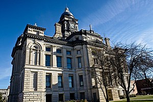
Wayne County is a county located in east central Indiana, United States, on the border with Ohio. As of the 2020 United States Census, the population was 66,553. The county seat is Richmond. Wayne County comprises the Richmond, IN Micropolitan Statistical Area. Richmond hosts Earlham College, a small private liberal arts college.

<span class="mw-page-title-main">Wabash County, Indiana</span> County in Indiana, United States

Wabash County is a county located in the northern central part of the U.S. state of Indiana. As of 2020, the population was 30,976. The county seat is Wabash.

<span class="mw-page-title-main">Vanderburgh County, Indiana</span> County in Indiana, United States

Vanderburgh County is a county in the U.S. state of Indiana. As of 2020, the population was 180,136. The county seat is in Evansville. While Vanderburgh County was the eighth-largest county in 2020 population in Indiana, it is also the eighth-smallest county in area and the smallest in southwestern Indiana, covering only 236 square miles (610 km2).

<span class="mw-page-title-main">Spencer County, Indiana</span> County in Indiana, United States

Spencer County is a county located in the U.S. state of Indiana. As of the 2020 census, the population was 19,810. The county seat is Rockport. Despite not being in the Owensboro Metropolitan Area, the entire riverfront of the city of Owensboro, Kentucky borders the southern tip of the county.

<span class="mw-page-title-main">Ripley County, Indiana</span> County in Indiana, United States

Ripley County is a county located at the southeastern corner of the U.S. state of Indiana. According to the 2020 Census, the population was 28,995. The county seat is Versailles.

<span class="mw-page-title-main">Perry County, Indiana</span> County in Indiana, United States

Perry County is a county located in the southwestern part of the U.S. state of Indiana. As of 2020, the population was 19,170. The county seat is Tell City. It is the hilliest county as well as one of the most forested counties in Indiana as it features more than 60,000 acres (240 km2) of Hoosier National Forest. The Ohio River Scenic Byway along Indiana State Road 66 runs along the southern border of the county while Interstate 64 traverses the northern portion of the county. Connecting the two is Indiana State Road 37.

<span class="mw-page-title-main">Noble County, Indiana</span> County in Indiana, United States

Noble County is a county in the U.S. state of Indiana. As of the 2020 United States Census, the population was 47,457. The county seat is Albion. The county is divided into 13 townships which provide local services.

<span class="mw-page-title-main">Miami County, Indiana</span> County in Indiana, United States

Miami County is a county located in the U.S. state of Indiana. As of 2020, the population was 35,962. The county seat is the City of Peru. Miami County is part of the Kokomo-Peru CSA.

<span class="mw-page-title-main">Martin County, Indiana</span> County in Indiana, United States

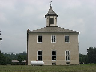
Martin County is a county in the U.S. state of Indiana. As of the 2020 United States Census, the population was 9,812. The county seat is Shoals at the center of the county, and the county's only incorporated city is Loogootee, on the county's western border.

<span class="mw-page-title-main">Jennings County, Indiana</span> County in Indiana, United States

Jennings County is a county located in the U.S. state of Indiana. As of 2020, the population was 27,613. The county seat is Vernon.

<span class="mw-page-title-main">Jefferson County, Indiana</span> County in Indiana, United States

Jefferson County is a county located in the U.S. state of Indiana. As of 2020, the population was 33,147. The county seat is Madison.

<span class="mw-page-title-main">Howard County, Indiana</span> County in Indiana, United States

Howard County is one of 92 counties in the U.S. state of Indiana. As of the 2020 census, the population was 83,658. The county seat is Kokomo. Originally named Richardville County, it was renamed in 1844 to commemorate General Tilghman Ashurst Howard.

<span class="mw-page-title-main">Henry County, Indiana</span> County in Indiana, United States

Henry County is a county located in east central Indiana, United States. As of 2020, the population was 48,914. The county seat and largest and only city is New Castle. Henry County is the main setting of the novel Raintree County by Ross Lockridge Jr.

<span class="mw-page-title-main">Dubois County, Indiana</span> County in Indiana, United States

Dubois County is a county located in the U.S. state of Indiana. As of 2020, the population was 43,637. The county seat is Jasper. Dubois County is now the sole county of the Jasper Micropolitan Statistical Area.

<span class="mw-page-title-main">Dearborn County, Indiana</span> County in Indiana, United States

Dearborn County is one of 92 counties of the U.S. state of Indiana. Located on the Ohio border near the southeast corner of the state, Dearborn County was formed in 1803 from a portion of Hamilton County, Ohio. In 2020, the population was 50,679. The county seat and largest city is Lawrenceburg. Dearborn County is part of the Cincinnati, OH-KY-IN Metropolitan Statistical Area.

<span class="mw-page-title-main">Crawford County, Indiana</span> County in Indiana, United States

Crawford County is a county located in the U.S. state of Indiana. As of 2020, the population was 10,526. The county seat is English.

<span class="mw-page-title-main">Cass County, Indiana</span> County in Indiana, United States

Cass County is a county located in the U.S. state of Indiana. As of the 2020 United States Census, its population was 37,870. The county seat is Logansport. Cass County comprises the Logansport, IN Micropolitan Statistical Area.

<span class="mw-page-title-main">Boone County, Indiana</span> County in Indiana, United States

Boone County is a county in the U.S. state of Indiana. As of 2020, the population was 70,812. The county seat is Lebanon.

<span class="mw-page-title-main">Frankfort, Indiana</span> City in Indiana, United States

Frankfort is a city in Clinton County, Indiana, United States. It had a population of 16,715 as of the 2020 census. The city is the county seat of Clinton County.

<span class="mw-page-title-main">DeKalb County, Indiana</span> County in Indiana, United States

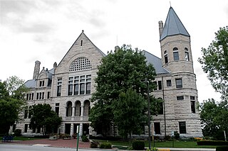
DeKalb County is a county in the U.S. state of Indiana. As of the 2020 United States Census, the population was 43,265. The county seat is Auburn.

References

  1. "Clinton County, Indiana". United States Census Bureau . Retrieved May 30, 2023.
  2. "Find a County". National Association of Counties. Archived from the original on May 31, 2011. Retrieved June 7, 2011.
  3. Claybaugh, Joseph (1913). History of Clinton County, Indiana. Indianapolis: A. W. Bowen & Company. pp.  31.
  4. "Lieutenant General James F. Record".
  5. 1 2 "Population, Housing Units, Area, and Density: 2010 - County". United States Census Bureau. Archived from the original on February 12, 2020. Retrieved July 10, 2015.
  6. 1 2 "Monthly Averages for Frankfort, Indiana". The Weather Channel. Retrieved January 27, 2011.
  7. 1 2 Indiana Code. "Title 36, Article 2, Section 3". IN.gov. Retrieved September 16, 2008.
  8. 1 2 3 4 Indiana Code. "Title 2, Article 10, Section 2" (PDF). IN.gov. Retrieved September 16, 2008.
  9. "Indiana Senate Districts". State of Indiana. Retrieved January 23, 2011.
  10. "Indiana House Districts". State of Indiana. Retrieved January 23, 2011.
  11. Leip, David. "Dave Leip's Atlas of U.S. Presidential Elections". uselectionatlas.org. Retrieved May 14, 2018.
  12. "Annual Estimates of the Resident Population for Counties: April 1, 2020 to July 1, 2023". United States Census Bureau. Retrieved April 2, 2024.
  13. "U.S. Decennial Census". United States Census Bureau. Retrieved July 10, 2014.
  14. "Historical Census Browser". University of Virginia Library. Archived from the original on December 26, 2013. Retrieved July 10, 2014.
  15. "Population of Counties by Decennial Census: 1900 to 1990". United States Census Bureau. Retrieved July 10, 2014.
  16. "Census 2000 PHC-T-4. Ranking Tables for Counties: 1990 and 2000" (PDF). United States Census Bureau. Retrieved July 10, 2014.
  17. "Clinton County QuickFacts". United States Census Bureau. Archived from the original on August 6, 2011. Retrieved September 17, 2011.
  18. 1 2 3 "DP-1 Profile of General Population and Housing Characteristics: 2010 Demographic Profile Data". United States Census Bureau. Archived from the original on February 13, 2020. Retrieved July 10, 2015.
  19. "DP02 SELECTED SOCIAL CHARACTERISTICS IN THE UNITED STATES – 2006-2010 American Community Survey 5-Year Estimates". United States Census Bureau. Archived from the original on February 14, 2020. Retrieved July 10, 2015.
  20. "DP03 SELECTED ECONOMIC CHARACTERISTICS – 2006-2010 American Community Survey 5-Year Estimates". United States Census Bureau. Archived from the original on February 14, 2020. Retrieved July 10, 2015.
  21. "P2 HISPANIC OR LATINO, AND NOT HISPANIC OR LATINO BY RACE – 2020: DEC Redistricting Data (PL 94-171) – Clinton County, Indiana".

40°18′N86°29′W / 40.30°N 86.48°W / 40.30; -86.48