Colfax, Indiana

Last updated

Colfax, Indiana
Colfax Carnegie Library from south.jpg
Clinton County Indiana Incorporated and Unincorporated areas Colfax Highlighted 1814284.svg
Location of Colfax in Clinton County, Indiana.
Coordinates: 40°11′39″N86°40′01″W / 40.19417°N 86.66694°W / 40.19417; -86.66694
Country United States
State Indiana
County Clinton
Township Perry
Founded1849
Named for Schuyler Colfax
Area
[1]
  Total0.37 sq mi (0.96 km2)
  Land0.37 sq mi (0.96 km2)
  Water0.00 sq mi (0.00 km2)
Elevation
[2]
843 ft (257 m)
Population
 (2020)
  Total702
  Density1,897.30/sq mi (733.11/km2)
Time zone UTC-5 (EST)
  Summer (DST) UTC-5 (EST)
ZIP code
46035
Area code 765
FIPS code 18-14284 [3]
GNIS feature ID2396658 [2]

Colfax is a town in Perry Township, Clinton County, Indiana, United States. The population was 691 at the 2010 census. The town was originally known as Midway since it was a half-way point on the IC&L Railroad between Chicago & Louisville. Railways intersected North/South & East/West making Colfax a popular transfer destination. The town was renamed to honor Vice President Schuyler Colfax [4] in 1857.

Contents

History

Colfax was laid out in 1849 by Montgomery Stroud. It was originally named Midway for its position between Chicago and Louisville along the IC&L railroad. In 1853 the town gained a post office named Colfax, and in December 1857 the name of the town itself became Colfax, by petition of the residents. By 1861 the town had two churches, two general stores, a hotel, a saw mill and approximately 200 residents.

An incorporation election held December 25, 1869, resulted in 24 yeas and 1 no. The town had 187 residents in 1870, but with the construction of the Vandalia railroad through town in 1870-71 it grew quickly and by 1880 had a population of 638. [5]

The Colfax Carnegie Library and Rosenberger Building are listed on the National Register of Historic Places. [6]

Geography

According to the 2010 census, Colfax has a total area of 0.36 square miles (0.93 km2), all land. [7]

Demographics

Historical population
CensusPop.Note
1870 187
1880 638241.2%
1890 73014.4%
1900 7675.1%
1910 8014.4%
1920 793−1.0%
1930 690−13.0%
1940 7173.9%
1950 7251.1%
1960 7250.0%
1970 633−12.7%
1980 82330.0%
1990 727−11.7%
2000 7685.6%
2010 691−10.0%
2020 7021.6%
U.S. Decennial Census [8]

2010 census

As of the census [9] of 2010, there were 691 people, 268 households, and 194 families living in the town. The population density was 1,919.4 inhabitants per square mile (741.1/km2). There were 322 housing units at an average density of 894.4 per square mile (345.3/km2). The racial makeup of the town was 96.1% White, 0.4% African American, 0.7% Asian, 0.3% from other races, and 2.5% from two or more races. Hispanic or Latino of any race were 3.2% of the population.

There were 268 households, of which 37.3% had children under the age of 18 living with them, 53.7% were married couples living together, 12.3% had a female householder with no husband present, 6.3% had a male householder with no wife present, and 27.6% were non-families. 23.5% of all households were made up of individuals, and 10.1% had someone living alone who was 65 years of age or older. The average household size was 2.58 and the average family size was 3.01.

The median age in the town was 40.1 years. 25.2% of residents were under the age of 18; 7.9% were between the ages of 18 and 24; 25.1% were from 25 to 44; 26.6% were from 45 to 64; and 15.2% were 65 years of age or older. The gender makeup of the town was 47.2% male and 52.8% female.

2000 census

As of the census [3] of 2000, there were 768 people, 286 households, and 205 families living in the town. The population density was 2,118.9 inhabitants per square mile (818.1/km2). There were 305 housing units at an average density of 841.5 per square mile (324.9/km2). The racial makeup of the town was 99.87% White and 0.13% Asian. Hispanic or Latino of any race were 1.69% of the population.

There were 286 households, out of which 36.0% had children under the age of 18 living with them, 59.8% were married couples living together, 7.0% had a female householder with no husband present, and 28.3% were non-families. 23.1% of all households were made up of individuals, and 11.9% had someone living alone who was 65 years of age or older. The average household size was 2.69 and the average family size was 3.18.

In the town, the population was spread out, with 29.3% under the age of 18, 7.6% from 18 to 24, 29.7% from 25 to 44, 21.1% from 45 to 64, and 12.4% who were 65 years of age or older. The median age was 34 years. For every 100 females, there were 95.4 males. For every 100 females age 18 and over, there were 93.9 males.

The median income for a household in the town was $42,688, and the median income for a family was $44,514. Males had a median income of $31,792 versus $28,000 for females. The per capita income for the town was $14,482. About 6.7% of families and 7.8% of the population were below the poverty line, including 5.5% of those under age 18 and 10.1% of those age 65 or over.

Education

The town has a free lending library, the Colfax-Perry Township Public Library. [10]

Related Research Articles

<span class="mw-page-title-main">Advance, Indiana</span> Town in Indiana, United States

Advance is a town in Jackson Township, Boone County, Indiana, United States. The population was 503 at the 2020 census.

<span class="mw-page-title-main">Frankfort, Indiana</span> City in Indiana, United States

Frankfort is a city in Clinton County, Indiana, United States. It had a population of 16,715 as of the 2020 census. The city is the county seat of Clinton County.

<span class="mw-page-title-main">Kirklin, Indiana</span> Town in Indiana, United States

Kirklin is a town in Kirklin Township, Clinton County, Indiana, United States. The population was 788 at the 2010 census. The town was named for Nathan Kirk, a local pioneer settler.

<span class="mw-page-title-main">Michigantown, Indiana</span> Town in Indiana, United States

Michigantown is a town in Michigan Township, Clinton County, Indiana, United States. The population was 467 at the 2010 census. The town was named for the Michigan Road, an early thoroughfare through the area.

<span class="mw-page-title-main">Mulberry, Indiana</span> Town in Indiana, United States

Mulberry is a town in Madison Township, Clinton County, Indiana, United States. The population was 1,231 at the 2020 census. The town was named for a mulberry tree which grew at the point where it was founded.

<span class="mw-page-title-main">Rossville, Indiana</span> Town in Indiana, United States

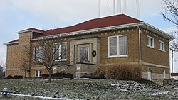
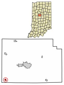
Rossville is a town in Ross Township, Clinton County, Indiana, United States. The population was 1,653 at the 2010 census.

<span class="mw-page-title-main">Milltown, Indiana</span> Town in Indiana, United States

Milltown is a town in Whiskey Run Township in Crawford County, Indiana and in Blue River and Spencer townships in Harrison County. The population was 818 at the time of the 2010 census.

<span class="mw-page-title-main">West Harrison, Indiana</span> Town in Indiana, United States

West Harrison is a town in Harrison Township, Dearborn County, Indiana, United States. The population was 289 at the 2010 census.

<span class="mw-page-title-main">St. Paul, Indiana</span> Town in Indiana, United States

St. Paul or Saint Paul is a small town on the border of Decatur and Shelby counties in the U.S. state of Indiana. The population was 1,031 at the 2010 census.

<span class="mw-page-title-main">Ashley, Indiana</span> Town in Indiana, United States

Ashley is a town in Indiana located on the border of Smithfield Township, DeKalb County and Steuben Township, Steuben County. The population was 983 at the 2010 census.

<span class="mw-page-title-main">McCordsville, Indiana</span> Town in Indiana, United States

McCordsville is a town in Vernon Township, Hancock County, Indiana, United States. The town is a fast-growing suburb of Indianapolis with an estimated population of 8,592 in 2020.

<span class="mw-page-title-main">Andrews, Indiana</span> Town in Indiana, United States

Andrews is a town in Dallas Township, Huntington County, Indiana, United States. The population was 1,048 at the 2020 census.

<span class="mw-page-title-main">Bethany, Indiana</span> Town in Indiana, United States

Bethany is a town in Clay Township, Morgan County, in the U.S. state of Indiana. The population was 95 at the 2020 census.

<span class="mw-page-title-main">Paragon, Indiana</span> Town in Indiana, United States

Paragon is a town in Ray Township, Morgan County, in the U.S. state of Indiana. The population was 556 at the 2020 census, down from 659 in 2010.

<span class="mw-page-title-main">Clear Lake, Indiana</span> Town in Indiana, United States

Clear Lake is a town located in the northeast corner of Steuben County, Indiana, in Clear Lake Township. As such, is the northeasternmost community in the State of Indiana. The population was 339 at the 2010 census.

<span class="mw-page-title-main">Colfax, North Dakota</span> City in North Dakota, United States

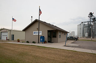
Colfax is a city in Richland County, North Dakota, United States. The population was 172 at the 2020 census. Colfax was founded in 1881. It is part of the Wahpeton, ND–MN Micropolitan Statistical Area. In the mid-1960s it billed itself as the "smallest town in the U.S. with a public swimming pool".

<span class="mw-page-title-main">Grant Township, Indiana County, Pennsylvania</span> Township in Pennsylvania, United States

Grant Township is a township in Indiana County, Pennsylvania, United States.

<span class="mw-page-title-main">North Crows Nest, Indiana</span> Town in Indiana, United States

North Crows Nest is a town in Washington Township, Marion County, Indiana, United States. It is approximately 7 miles (11 km) north of downtown Indianapolis. The population was 44 at the 2020 census. It has existed as an "included town" since 1970, when it was incorporated into Indianapolis as part of Unigov. It is part of Indianapolis, but retains town governmental powers under IC 36-3-1-11.

Colfax is a town in Dunn County, Wisconsin, United States. The population was 909 at the 2000 census.

<span class="mw-page-title-main">Colfax, Wisconsin</span> Village in Wisconsin, United States

Colfax is a village in Dunn County, Wisconsin, United States. The population was 1,158 at the 2010 census. The village is surrounded by the Town of Colfax.

References

  1. "2020 U.S. Gazetteer Files". United States Census Bureau. Retrieved March 16, 2022.
  2. 1 2 U.S. Geological Survey Geographic Names Information System: Colfax, Indiana
  3. 1 2 "U.S. Census website". United States Census Bureau . Retrieved January 31, 2008.
  4. Claybaugh, Joseph (1913). History of Clinton County, Indiana. Indianapolis: A. W. Bowen & Company. pp.  32.
  5. Claybaugh, Joseph (1913). "Perry Township". History of Clinton County, Indiana. Indianapolis: A. W. Bowen & Company.
  6. "National Register Information System". National Register of Historic Places . National Park Service. July 9, 2010.
  7. "G001 - Geographic Identifiers - 2010 Census Summary File 1". United States Census Bureau. Archived from the original on February 13, 2020. Retrieved July 16, 2015.
  8. "Census of Population and Housing". Census.gov. Retrieved June 4, 2015.
  9. "U.S. Census website". United States Census Bureau . Retrieved December 11, 2012.
  10. "Indiana public library directory" (PDF). Indiana State Library. Archived from the original (PDF) on February 18, 2017. Retrieved March 4, 2018.