Frankfort, Indiana

Last updated

Frankfort, Indiana
Clinton County Indiana Courthouse.jpg
Flag of Frankfort, Indiana.svg
Clinton County Indiana Incorporated and Unincorporated areas Frankfort Highlighted 1825324.svg
Location of Frankfort in Clinton County, Indiana.
Coordinates: 40°16′47″N86°30′21″W / 40.27972°N 86.50583°W / 40.27972; -86.50583
Country United States
State Indiana
County Clinton
Township Center
Founded1830
Incorporated1846
Named for Frankfurt am Main
Government
  MayorJudith Sheets (R)
Area
[1]
  Total8.05 sq mi (20.86 km2)
  Land8.05 sq mi (20.86 km2)
  Water0.00 sq mi (0.00 km2)
Elevation
[2]
860 ft (260 m)
Population
 (2020)
  Total16,715
  Density2,075.11/sq mi (801.21/km2)
Time zone UTC-5 (EST)
  Summer (DST) UTC-4 (EDT)
ZIP code
46041
Area code 765
FIPS code 18-25324 [3]
GNIS feature ID2394805 [2]
Website frankfort-in.gov

Frankfort is a city in Clinton County, Indiana, United States. It had a population of 16,715 as of the 2020 census. The city is the county seat of Clinton County. [4]

Contents

History

Brothers John, William and Nicholas Pence, previously of Warren County, Ohio, settled on the land on which Frankfort now stands in 1829, having entered it from the government in 1827 and 1828. In 1830, the brothers donated 60 acres (240,000 m2) of the land to the county commissioners, a donation which led to the establishment of the county seat at that site rather than in Jefferson, a community which had also been vying for the honor. The new town was named Frankfort at the brothers' request and honors their German great-grandparents' home of Frankfurt am Main. [5]

The town of Frankfort was laid off on the 60-acre (240,000 m2) tract by William Douglass, the county agent, and the plat filed on June 8, 1830. The original plat consisted of 64 lots in eight blocks surrounding a public square where the courthouse now stands. The county board paid contractors Allen & Michael the sum of $20 to erect the first courthouse, a 1+12-story temporary structure made of logs hewn from trees that grew on the square and surrounding streets. Its replacement was built by contractor John Elder in 1837 and 1838 for $12,000 and operated for 45 years. Indianapolis architect George W. Bunting in 1881 designed the third courthouse, a 165-foot (50 m) tall structure built of Indiana limestone by contractors Farman & Pearce for approximately $200,000. Its cornerstone was laid September 2, 1882. [6]

The youngest elected mayor of Frankfort was Robert Keene at the age of 21 when he took office in January 1922 just one month prior to the fire at Old Stoney on February 24, 1922. At the time of the fire, Old Stoney was used as the high school. Today, Old Stoney is used as City Hall.

In addition to Old Stoney, the Christian Ridge Historic District, Clinton County Courthouse, Charles H. and Emma Condon House, Frankfort Commercial Historic District, and South Frankfort Historic District are listed on the National Register of Historic Places. [7]

Geography

According to the 2010 census, Frankfort has a total area of 6.31 square miles (16.34 km2), all land. [8]

Demographics

Historical population
CensusPop.Note
1850 582
1860 77332.8%
1870 1,30068.2%
1880 2,803115.6%
1890 5,919111.2%
1900 7,10020.0%
1910 8,63421.6%
1920 11,58534.2%
1930 12,1965.3%
1940 13,70612.4%
1950 15,0289.6%
1960 15,3021.8%
1970 14,956−2.3%
1980 15,1681.4%
1990 14,754−2.7%
2000 16,66212.9%
2010 16,422−1.4%
2020 16,7151.8%
Source: US Census Bureau

2010 census

As of the census [9] of 2010, there were 16,422 people, 5,835 households, and 3,972 families living in the city. The population density was 2,602.5 inhabitants per square mile (1,004.8/km2). There were 6,551 housing units at an average density of 1,038.2 per square mile (400.9/km2). The racial makeup of the city was 71.9% White, 0.6% African American, 0.3% Native American, 0.2% Asian, 13.1% from other races, and 1.8% from two or more races. Hispanic or Latino of any race were 27.0% of the population.

There were 5,835 households, of which 38.2% had children under the age of 18 living with them, 47.0% were married couples living together, 14.9% had a female householder with no husband present, 6.2% had a male householder with no wife present, and 31.9% were non-families. 26.5% of all households were made up of individuals, and 11.2% had someone living alone who was 65 years of age or older. The average household size was 2.71 and the average family size was 3.26.

The median age in the city was 33.5 years. 28.2% of residents were under the age of 18; 9.9% were between the ages of 18 and 24; 25.4% were from 25 to 44; 22.8% were from 45 to 64; and 13.8% were 65 years of age or older. The gender makeup of the city was 49.3% male and 50.7% female.

2000 census

As of the census [3] of 2000, there were 16,662 people, 6,279 households, and 4,175 families living in the city. The population density was 3,240.5 inhabitants per square mile (1,251.2/km2). There were 6,682 housing units at an average density of 1,299.6 per square mile (501.8/km2). The racial makeup of the city was 70.08% White, 0.47% African American, 0.16% Native American, 0.28% Asian, 0.03% Pacific Islander, 7.84% from other races, and 1.14% from two or more races. Hispanic or Latino of any race were 20.53% of the population.

There were 6,279 households, out of which 33.0% had children under the age of 18 living with them, 49.5% were married couples living together, 11.8% had a female householder with no husband present, and 33.5% were non-families. 28.7% of all households were made up of individuals, and 13.6% had someone living alone who was 65 years of age or older. In the city, the population was spread out, with 27.0% under the age of 18, 10.9% from 18 to 24, 27.3% from 25 to 44, 19.1% from 45 to 64, and. 15.7% who were 65 years of age or older. The median age was 34 years. For every 100 females, there were 95.0 males. For every 100 females age 18 and over, there were 90.0 males.

The median income for a household in the city was $33,275, and the median income for a family was $42,686. Males had a median income of $32,092 versus $23,722 for females. The per capita income for the city was $15,393. About 8.8% of families and 11.7% of the population were below the poverty line, including 12.1% of those under age 18 and 10.9% of those age 65 or over.

Transportation

Airport

Frankfort is served by the Frankfort Municipal Airport.

Highways

U.S. 421 and Indiana state routes 28, 39 and 75 converge in the city. Interstate 65 is a short distance to the west of Frankfort.

Rail

The city is at the junction of several rail lines. The Monon Railroad (The Hoosier and the Tippecanoe Chicago-Indianapolis trains), [10] New York, Chicago and St. Louis Railroad (Nickel Plate) (The Blue Arrow and the Blue Dart St. Louis-Cleveland trains) [11] and the Pennsylvania Railroad (The Kentuckian [Chicago-Indianapolis] and South Wind [Chicago-Miami/Tampa/St. Petersburg] trains) ran passenger trains through the city. [12] Successor railroads such as CSX and Norfolk Southern have the tracks or right of ways of the routes today.

Notable people

Education

Public

In the fall of 2013 Ivy Tech opened a campus in Frankfort on a site that once housed The Frankfort Times, the local newspaper.

The city has a free lending library, the Frankfort Community Public Library. [13]

Related Research Articles

<span class="mw-page-title-main">Clinton County, Indiana</span> County in Indiana, United States

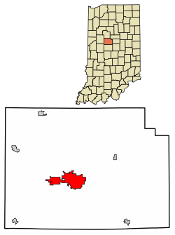
Clinton County is a county located in the U.S. state of Indiana. As of 2020, the population was 33,190. The county seat is Frankfort.

<span class="mw-page-title-main">Jamestown, Indiana</span> Town in Indiana, United States

Jamestown is a town in Jackson Township, Boone County and Eel River Township, Hendricks County, Indiana, United States. The population was 958 at the 2010 census.

<span class="mw-page-title-main">Lebanon, Indiana</span> City in Indiana, United States

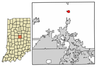
Lebanon is a city in and the county seat of Boone County, Indiana, United States. The population was 15,792 at the 2010 census. Lebanon is located in central Indiana, approximately 29 miles (47 km) northwest of downtown Indianapolis and 36 miles (58 km) southeast of Lafayette.

<span class="mw-page-title-main">Whitestown, Indiana</span> Town in Indiana, United States

Whitestown is a town in Boone County, Indiana, United States. The population was 10,187 at the 2020 census. The town is located near Interstate 65, approximately 22 miles (35 km) northwest of Downtown Indianapolis, and about 7 miles (11 km) from the northern city limits of Indianapolis, between exits 130 and 133. Since 2010, Whitestown has been the fastest-growing municipality in Indiana; its population increased more than threefold between the 2010 and 2020 Census tabulations.

<span class="mw-page-title-main">Zionsville, Indiana</span> Town in Indiana, United States

Zionsville is a suburban town located in the extreme southeast area of Boone County, Indiana, United States, northwest of Indianapolis. The population was 14,160 at the 2010 census, 30,693 at the 2020 census.

<span class="mw-page-title-main">Colfax, Indiana</span> Town in Indiana, United States

Colfax is a town in Perry Township, Clinton County, Indiana, United States. The population was 691 at the 2010 census. The town was originally known as Midway since it was a half-way point on the IC&L Railroad between Chicago & Louisville. Railways intersected North/South & East/West making Colfax a popular transfer destination. The town was renamed to honor Vice President Schuyler Colfax in 1857.

<span class="mw-page-title-main">Kirklin, Indiana</span> Town in Indiana, United States

Kirklin is a town in Kirklin Township, Clinton County, Indiana, United States. The population was 788 at the 2010 census. The town was named for Nathan Kirk, a local pioneer settler.

<span class="mw-page-title-main">Michigantown, Indiana</span> Town in Indiana, United States

Michigantown is a town in Michigan Township, Clinton County, Indiana, United States. The population was 467 at the 2010 census. The town was named for the Michigan Road, an early thoroughfare through the area.

<span class="mw-page-title-main">Mulberry, Indiana</span> Town in Indiana, United States

Mulberry is a town in Madison Township, Clinton County, Indiana, United States. The population was 1,231 at the 2020 census. The town was named for a mulberry tree which grew at the point where it was founded.

<span class="mw-page-title-main">Rossville, Indiana</span> Town in Indiana, United States

Rossville is a town in Ross Township, Clinton County, Indiana, United States. The population was 1,653 at the 2010 census.

<span class="mw-page-title-main">Arcadia, Indiana</span> Town in Indiana, United States

Arcadia is a town in Jackson Township, Hamilton County, Indiana, United States. The population was 1,666 at the 2010 census.

<span class="mw-page-title-main">Greenfield, Indiana</span> City in Indiana, United States

Greenfield is a city in and the county seat of Hancock County, Indiana, United States It lies in Center Township and is part of the Indianapolis metropolitan area. The population was 23,488 at the 2020 census.

<span class="mw-page-title-main">Blountsville, Indiana</span> Town in Indiana, United States

Blountsville is a town in Stoney Creek Township, Henry County, Indiana, United States. The population was 98 at the 2020 census.

<span class="mw-page-title-main">Vernon, Indiana</span> Town in Indiana, United States

Vernon is a town within Vernon Township and the county seat of Jennings County, Indiana, United States. With a population of 318 in the 2010 census, it is the smallest town with that designation in the state of Indiana, lying just south of the much larger North Vernon. It is nearly surrounded by the Muscatatuck River. Vernon is the only Indiana town with an elected mayor and an elected town marshal. As of 2023, Marshall Zamora is the mayor and Britt Burgmeier is the marshal.

<span class="mw-page-title-main">Southport, Indiana</span> City in Indiana, United States

Southport is an excluded city in Marion County, Indiana, United States. The population was 2,123 at the 2020 census, up from 1,712 in 2010.

<span class="mw-page-title-main">New Market, Indiana</span> Town in Indiana, United States

New Market is a town in Montgomery County, Indiana, in the United States. The population was 559 at the 2020 census, down from 636 in 2010.

<span class="mw-page-title-main">Martinsville, Indiana</span> City in Indiana, United States

Martinsville is a city in Washington Township, Morgan County, in the U.S. state of Indiana. The population was 12,309 at the 2020 United States Census. The city is the county seat of Morgan County.

<span class="mw-page-title-main">Rushville, Indiana</span> City in Indiana, United States

Rushville is a city in Rushville Township, Rush County, in the U.S. state of Indiana. The population was 6,185 at the 2020 census. The city is the county seat of Rush County. It, like the county, was named in honor of Dr. Benjamin Rush, who signed the Declaration of Independence.

<span class="mw-page-title-main">Shelbyville, Indiana</span> City in Indiana, United States

Shelbyville is a city in Addison Township, Shelby County, in the U.S. state of Indiana and is the county seat. The population was 20,067 as of the 2020 census.

<span class="mw-page-title-main">Bluffton, Indiana</span> City in Indiana, United States

Bluffton is a city in and the county seat of Wells County, Indiana, United States. The population was 10,308 at the 2020 census, up from 9,897 at the 2010 census. Bluffton is nicknamed the "Parlor City" for its history of having some of the first clean paved streets in the area during the time of the Indiana gas boom.

References

  1. "2020 U.S. Gazetteer Files". United States Census Bureau. Retrieved March 16, 2022.
  2. 1 2 U.S. Geological Survey Geographic Names Information System: Frankfort, Indiana
  3. 1 2 "U.S. Census website". United States Census Bureau . Retrieved January 31, 2008.
  4. "Find a County". National Association of Counties. Archived from the original on May 31, 2011. Retrieved June 7, 2011.
  5. Claybaugh, Joseph (1913). "City of Frankfort". History of Clinton County, Indiana. Indianapolis: A. W. Bowen & Company.
  6. Claybaugh, Joseph (1913). "Civil History". History of Clinton County, Indiana. Indianapolis: A. W. Bowen & Company.
  7. "National Register Information System". National Register of Historic Places . National Park Service. July 9, 2010.
  8. "G001 - Geographic Identifiers - 2010 Census Summary File 1". United States Census Bureau. Archived from the original on February 13, 2020. Retrieved July 28, 2015.
  9. "U.S. Census website". United States Census Bureau . Retrieved December 11, 2012.
  10. "Monon Railroad, Table 1". Official Guide of the Railways. 91 (3). National Railway Publication Company. August 1958.
  11. "Nickel Plate Road, Table 2". Official Guide of the Railways. 91 (3). National Railway Publication Company. August 1958.
  12. Pennsylvania Railroad timetable, July 26, 1964, Tables 1, 13 http://streamlinermemories.info/PRR/PRR7-64TT.pdf
  13. "Indiana public library directory" (PDF). Indiana State Library. Archived from the original (PDF) on February 18, 2017. Retrieved March 4, 2018.