Spencer, Indiana

Last updated

Spencer, Indiana
Owen County Indiana Courthouse.jpg
Owen County courthouse in Spencer
Owen County Indiana Incorporated and Unincorporated areas Spencer Highlighted 1871972.svg
Location of Spencer in Owen County, Indiana.
Coordinates: 39°17′13″N86°45′51″W / 39.28694°N 86.76417°W / 39.28694; -86.76417
Country United States
State Indiana
County Owen
Township Washington
Area
[1]
  Total1.59 sq mi (4.13 km2)
  Land1.59 sq mi (4.13 km2)
  Water0.00 sq mi (0.00 km2)
Elevation
[2]
564 ft (172 m)
Population
 (2020)
  Total2,454
  Density1,539.52/sq mi (594.30/km2)
Time zone UTC-5 (Eastern (EST))
  Summer (DST) UTC-4 (EDT)
ZIP code
47460
Area code 812
FIPS code 18-71972 [3]
GNIS feature ID 443934
Website http://www.spencer.in.gov/
The Cinema 67 Drive-in theatre near Spencer, IN Cinema 67.jpg
The Cinema 67 Drive-in theatre near Spencer, IN

Spencer is a town in Washington Township, Owen County, in the U.S. state of Indiana. [4] The population was 2,217 at the 2010 census. It is the county seat of Owen County. [5]

Contents

Spencer is part of the Bloomington, Indiana Metropolitan Statistical Area.

History

Spencer was platted in 1820, and named for Captain Spier Spencer, who fell at the Battle of Tippecanoe, after whom Spencer County is also named. [6] A post office has been in operation at Spencer since 1821. [7] The current building was constructed with New Deal funds in 1938. [8]

The Allison-Robinson House, David Enoch Beem House, Owen County Courthouse, Spencer Public Library, and Spencer Town Hall and Fire Station are listed on the National Register of Historic Places. [9]

Downtown events include Christmas at the Square, Spencer Pride Festival, and the Rev20 Christian Music Festival.

Geography

According to the 2010 census, Spencer has a total area of 1.26 square miles (3.26 km2), all land. [10]

Climate

The climate in this area is characterized by hot, humid summers and generally mild to cool winters. According to the Köppen Climate Classification system, Spencer has a humid subtropical climate, abbreviated "Cfa" on climate maps. [11]

Climate data for Spencer, Indiana (Spencer) 1991–2020 normals, extremes 1946–present
MonthJanFebMarAprMayJunJulAugSepOctNovDecYear
Record high °F (°C)73
(23)
77
(25)
85
(29)
89
(32)
95
(35)
104
(40)
107
(42)
102
(39)
104
(40)
93
(34)
84
(29)
76
(24)
107
(42)
Mean daily maximum °F (°C)37.2
(2.9)
41.7
(5.4)
52.3
(11.3)
64.4
(18.0)
73.9
(23.3)
82.1
(27.8)
85.4
(29.7)
84.4
(29.1)
78.8
(26.0)
66.9
(19.4)
53.0
(11.7)
41.9
(5.5)
63.5
(17.5)
Daily mean °F (°C)28.7
(−1.8)
32.1
(0.1)
41.5
(5.3)
52.5
(11.4)
62.5
(16.9)
71.2
(21.8)
74.7
(23.7)
73.2
(22.9)
66.4
(19.1)
54.5
(12.5)
42.7
(5.9)
33.4
(0.8)
52.8
(11.6)
Mean daily minimum °F (°C)20.2
(−6.6)
22.6
(−5.2)
30.6
(−0.8)
40.6
(4.8)
51.1
(10.6)
60.2
(15.7)
64.0
(17.8)
62.0
(16.7)
54.0
(12.2)
42.1
(5.6)
32.3
(0.2)
25.0
(−3.9)
42.1
(5.6)
Record low °F (°C)−33
(−36)
−23
(−31)
−12
(−24)
15
(−9)
26
(−3)
34
(1)
39
(4)
40
(4)
28
(−2)
14
(−10)
−4
(−20)
−24
(−31)
−33
(−36)
Average precipitation inches (mm)3.45
(88)
2.64
(67)
3.65
(93)
5.34
(136)
5.19
(132)
5.82
(148)
4.93
(125)
3.58
(91)
3.76
(96)
3.86
(98)
4.01
(102)
3.46
(88)
49.69
(1,262)
Average snowfall inches (cm)6.9
(18)
4.2
(11)
1.5
(3.8)
0.1
(0.25)
0.0
(0.0)
0.0
(0.0)
0.0
(0.0)
0.0
(0.0)
0.0
(0.0)
0.0
(0.0)
0.3
(0.76)
2.8
(7.1)
15.8
(40)
Average precipitation days (≥ 0.01 in)11.79.811.112.913.011.810.37.77.89.19.911.0126.1
Average snowy days (≥ 0.1 in)3.92.80.80.10.00.00.00.00.00.00.22.410.2
Source: NOAA [12] [13]

Demographics

Historical population
CensusPop.Note
1850 335
1870 971
1880 1,65570.4%
1890 1,86812.9%
1900 2,0268.5%
1910 2,1506.1%
1920 2,066−3.9%
1930 2,1795.5%
1940 2,3759.0%
1950 2,3940.8%
1960 2,5576.8%
1970 2,553−0.2%
1980 2,7327.0%
1990 2,609−4.5%
2000 2,508−3.9%
2010 2,217−11.6%
2020 2,45410.7%
U.S. Decennial Census [14]

2010 census

As of the census [15] of 2010, there were 2,217 people, 1,008 households, and 554 families living in the town. The population density was 1,759.5 inhabitants per square mile (679.3/km2). There were 1,123 housing units at an average density of 891.3 per square mile (344.1/km2). The racial makeup of the town was 98.1% White, 0.1% African American, 0.2% Native American, 0.5% Asian, 0.2% from other races, and 0.9% from two or more races. Hispanic or Latino of any race were 2.1% of the population.

There were 1,008 households, of which 24.6% had children under the age of 18 living with them, 38.4% were married couples living together, 12.8% had a female householder with no husband present, 3.8% had a male householder with no wife present, and 45.0% were non-families. 40.1% of all households were made up of individuals, and 18.4% had someone living alone who was 65 years of age or older. The average household size was 2.12 and the average family size was 2.81.

The median age in the town was 41.8 years. 20.1% of residents were under the age of 18; 9.4% were between the ages of 18 and 24; 24.2% were from 25 to 44; 26.3% were from 45 to 64; and 19.8% were 65 years of age or older. The gender makeup of the town was 47.2% male and 52.8% female.

2000 census

As of the census [3] of 2000, there were 2,508 people, 1,090 households, and 659 families living in the town. The population density was 1,984.6 inhabitants per square mile (766.3/km2). There were 1,193 housing units at an average density of 944.0 per square mile (364.5/km2). The racial makeup of the town was 98.52% White, 0.20% African American, 0.40% Asian, 0.24% from other races, and 0.64% from two or more races. Hispanic or Latino of any race were 0.60% of the population.

There were 1,090 households, out of which 27.2% had children under the age of 18 living with them, 45.1% were married couples living together, 12.8% had a female householder with no husband present, and 39.5% were non-families. 35.0% of all households were made up of individuals, and 18.5% had someone living alone who was 65 years of age or older. The average household size was 2.23 and the average family size was 2.88.

In the town, the population was spread out, with 23.0% under the age of 18, 10.1% from 18 to 24, 26.7% from 25 to 44, 20.3% from 45 to 64, and 20.0% who were 65 years of age or older. The median age was 39 years. For every 100 females, there were 83.2 males. For every 100 females age 18 and over, there were 81.9 males.

The median income for a household in the town was $28,664, and the median income for a family was $36,921. Males had a median income of $29,679 versus $21,531 for females. The per capita income for the town was $15,843. About 8.4% of families and 9.5% of the population were below the poverty line, including 13.2% of those under age 18 and 8.8% of those age 65 or over.

Education

Owen Valley Community High School (OVHS) is located in Spencer with 980 students and more than 100 faculty members. Built in 1971, OVHS is the result of a consolidation of several smaller schools located within Owen County. Owen Valley's mascot is the Patriot, and the school's colors are red, white and blue. The school's yearbook is the Triad, Tri- representing the three schools that were merged to create Owen Valley High School.

The town has a lending library, the Owen County Public Library. [16]

Notable people

Related Research Articles

<span class="mw-page-title-main">Jonesville, Indiana</span> Town in Indiana, United States

Jonesville is a town in Wayne Township, Bartholomew County, in the U.S. state of Indiana. The population was 177 at the 2010 census. It is part of the Columbus, Indiana metropolitan statistical area.

<span class="mw-page-title-main">Center Point, Indiana</span> Town in Indiana, United States

Center Point is a town in Sugar Ridge Township, Clay County, Indiana, United States. The population was 242 at the 2010 census. It is part of the Terre Haute Metropolitan Statistical Area.

<span class="mw-page-title-main">English, Indiana</span> Town in Indiana, United States

English is a town and the county seat of Crawford County, Indiana, United States. The population was 645 at the 2010 census, making it one of Indiana's smallest county seats. The settlement was named Hartford (1839-1884) prior to its incorporation.

<span class="mw-page-title-main">Milltown, Indiana</span> Town in Indiana, United States

Milltown is a town in Whiskey Run Township in Crawford County, Indiana and in Blue River and Spencer townships in Harrison County. The population was 818 at the time of the 2010 census.

<span class="mw-page-title-main">Dillsboro, Indiana</span> Town in Indiana, United States

Dillsboro is a town in Clay Township, Dearborn County, Indiana, United States. As of 2020, the population is 1,360.

<span class="mw-page-title-main">Brookville, Indiana</span> Town in Indiana, United States

Brookville is a town in Brookville Township, Franklin County, Indiana, United States. The town is the county seat of and the largest community entirely within Franklin County. The population was 2,596 at the 2010 census.

<span class="mw-page-title-main">Switz City, Indiana</span> Town in Indiana, United States

Switz City is a town in Fairplay and Grant townships, Greene County, Indiana, United States. The population was 293 at the 2010 census. It is part of the Bloomington, Indiana, Metropolitan Statistical Area.

<span class="mw-page-title-main">Whiteland, Indiana</span> Town in Indiana, United States

Whiteland is a town in Pleasant, Franklin and Clark townships, Johnson County, Indiana, United States. The population was 4,599 at the 2020 census.

<span class="mw-page-title-main">Bruceville, Indiana</span> Town in Indiana, United States

Bruceville is a town in Washington Township, Knox County, Indiana, United States. The population was 478 at the 2010 census.

<span class="mw-page-title-main">Oolitic, Indiana</span> Town in Indiana, United States

Oolitic is a town in Indian Creek and Shawswick townships, Lawrence County, Indiana, United States. The population was 1,184 at the 2010 census.

<span class="mw-page-title-main">Paragon, Indiana</span> Town in Indiana, United States

Paragon is a town in Ray Township, Morgan County, in the U.S. state of Indiana. The population was 556 at the 2020 census, down from 659 in 2010.

<span class="mw-page-title-main">Paoli, Indiana</span> Town in Indiana, United States

Paoli is a town within Paoli Township and the county seat of Orange County, in the U.S. state of Indiana. The population was 3,677 at the 2010 census.

<span class="mw-page-title-main">Cannelton, Indiana</span> City in Indiana, United States

Cannelton is a city in Troy Township, Perry County, in the U.S. state of Indiana, along the Ohio River. The population was 1,563 at the 2010 census. Cannelton, which was the smallest incorporated city in the state until 2010, was formerly the county seat of Perry County until the seat was relocated to Tell City.

<span class="mw-page-title-main">Troy, Indiana</span> Town in Indiana, United States

Troy is a town in Troy Township, Perry County, Indiana, along the Ohio River near the mouth of the Anderson River. It is the second oldest city in Indiana. The population was 347 at the 2020 census.

<span class="mw-page-title-main">Winslow, Indiana</span> Town in Indiana, United States

Winslow is a town in Patoka Township, Pike County, in the U.S. state of Indiana. The population was 864 at the 2010 census. It is part of the Jasper Micropolitan Statistical Area.

<span class="mw-page-title-main">Poseyville, Indiana</span> Town in Indiana, United States

Poseyville is a town in Robb Township, Posey County, in the U.S. state of Indiana. The population was 1,045 at the 2010 census.

<span class="mw-page-title-main">Sunman, Indiana</span> Town in Indiana, United States

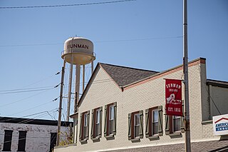
Sunman is a town in Adams Township, Ripley County, in the U.S. state of Indiana. The population was 1,049 at the 2010 census.

<span class="mw-page-title-main">Chrisney, Indiana</span> Town in Indiana, United States

Chrisney is a town in Grass Township, Spencer County, in the U.S. state of Indiana. The population was 481 at the 2010 census.

<span class="mw-page-title-main">Dale, Indiana</span> Town in Indiana, United States

Dale is a town in Carter Township, Spencer County, in the U.S. state of Indiana. The population was 1,593 at the 2010 census.

<span class="mw-page-title-main">Grandview, Indiana</span> Town in Indiana, United States

Grandview is a town in Hammond Township, Spencer County, Indiana, along the Ohio River. The population was 749 at the 2010 census.

References

  1. "2020 U.S. Gazetteer Files". United States Census Bureau. Retrieved March 16, 2022.
  2. "US Board on Geographic Names". United States Geological Survey. October 25, 2007. Retrieved January 31, 2008.
  3. 1 2 "U.S. Census website". United States Census Bureau . Retrieved January 31, 2008.
  4. "Spencer, Indiana". Geographic Names Information System . United States Geological Survey, United States Department of the Interior . Retrieved April 30, 2017.
  5. "Find a County". National Association of Counties. Retrieved June 7, 2011.
  6. Blanchard, Charles (1884). Counties of Clay and Owen, Indiana: Historical and Biographical. F.A. Battey & Company. pp.  665.
  7. "Owen County". Jim Forte Postal History. Retrieved September 21, 2015.
  8. "Post Office - Spencer IN". Living New Deal. Retrieved January 4, 2021.
  9. "National Register Information System". National Register of Historic Places . National Park Service. July 9, 2010.
  10. "G001 - Geographic Identifiers - 2010 Census Summary File 1". United States Census Bureau. Archived from the original on February 13, 2020. Retrieved July 25, 2015.
  11. Climate Summary for Spencer, Indiana
  12. "NowData – NOAA Online Weather Data". National Oceanic and Atmospheric Administration. Retrieved August 2, 2021.
  13. "Station: Spencer, IN" (PDF). U.S. Climate Normals 2020: U.S. Monthly Climate Normals (1991–2020). National Oceanic and Atmospheric Administration. Retrieved August 2, 2021.
  14. "Census of Population and Housing". Census.gov. Retrieved June 4, 2015.
  15. "U.S. Census website". United States Census Bureau . Retrieved December 11, 2012.
  16. "Indiana public library directory" (PDF). Indiana State Library. Archived from the original (PDF) on February 18, 2017. Retrieved March 14, 2018.