LaGrange, Indiana

Last updated

LaGrange
LaGrange County Courthouse.jpg
LaGrange County Indiana Incorporated and Unincorporated areas Lagrange Highlighted 1840860.svg
Location of Lagrange in LaGrange County, Indiana.
Coordinates: 41°38′53″N85°25′05″W / 41.64806°N 85.41806°W / 41.64806; -85.41806
Country United States
State Indiana
County LaGrange
Area
[1]
  Total1.79 sq mi (4.62 km2)
  Land1.79 sq mi (4.62 km2)
  Water0.00 sq mi (0.00 km2)
Elevation
[2]
919 ft (280 m)
Population
 (2020)
  Total2,715
  Density1,520.16/sq mi (587.08/km2)
Time zone UTC-5 (EST)
  Summer (DST) UTC-5 (EST)
ZIP code
46761
Area code 260
FIPS code 18-40860 [3]
GNIS feature ID2396703 [2]

LaGrange is a town in and the county seat of LaGrange County, Indiana, United States. [4] The population was 2,625 at the 2010 census.

Contents

History

LaGrange was laid out and platted in 1836. [5] It took its name from LaGrange County. [6]

LaGrange County's initial settlers were Yankee immigrants, that is to say they were from New England and were descended from the English Puritans who settled that region in the colonial era. They were part of a wave of New England settlers moving west into what was then the Northwest Territory after the completion of the Erie Canal. The original settlers in LaGrange County specifically hailed from the Massachusetts counties of Worcester County, Suffolk County and Berkshire County; the Connecticut counties of Hartford County and Windham County as well as the Connecticut towns of Sherman, Lebanon and Fairfield; and from the Vermont towns of Burlington, Brookfield, Huntington and Grand Isle. They were mainly members of the Congregational Church, but as a result of the Second Great Awakening many became Baptists and many also converted to Pentecostalism and Methodism. When they arrived in what is now LaGrange County, there was nothing but virgin forest and wild prairie, the New England settlers cleared roads, built farms, constructed churches, erected government buildings, and established post routes. As a result of this migration, LaGrange County was culturally continuous with early New England culture for many years. [7]

The LaGrange County Courthouse was listed on the National Register of Historic Places in 1980. [8] The courthouse and the annual fall festival are featured in the 1941 New Deal era post office mural painted by Jessie Hull Mayer. She won the federal commission to paint Corn School as part of the Section of Painting and Sculpture′s projects, later called the Section of Fine Arts, of the Treasury Department. [9]

Geography

According to the 2010 census, LaGrange has a total area of 1.7 square miles (4.40 km2), all land. [10]

Demographics

Historical population
CensusPop.Note
1860 650
1870 1,03859.7%
1880 1,36731.7%
1890 1,78430.5%
1900 1,703−4.5%
1910 1,7724.1%
1920 1,610−9.1%
1930 1,6401.9%
1940 1,81410.6%
1950 1,8924.3%
1960 1,9905.2%
1970 2,0533.2%
1980 2,1645.4%
1990 2,38210.1%
2000 2,91922.5%
2010 2,625−10.1%
2020 2,7153.4%
U.S. Decennial Census [11]

2020 census

As of the census [12] of 2020, there were 2,715 people, 1,143 households, and 687 families living in the town.

2010 census

As of the census [13] of 2010, there were 2,625 people, 1,041 households, and 637 families living in the town. The population density was 1,544.1 inhabitants per square mile (596.2/km2). There were 1,221 housing units at an average density of 718.2 per square mile (277.3/km2). The racial makeup of the town was 93.7% White, 0.6% African American, 0.4% Native American, 0.4% Asian, 4.2% from other races, and 0.7% from two or more races. Hispanic or Latino of any race were 9.5% of the population.

There were 1,041 households, of which 33.5% had children under the age of 18 living with them, 43.2% were married couples living together, 13.3% had a female householder with no husband present, 4.7% had a male householder with no wife present, and 38.8% were non-families. 34.3% of all households were made up of individuals, and 15.3% had someone living alone who was 65 years of age or older. The average household size was 2.43 and the average family size was 3.17.

The median age in the town was 37.7 years. 27% of residents were under the age of 18; 7.5% were between the ages of 18 and 24; 24.6% were from 25 to 44; 22.9% were from 45 to 64; and 17.8% were 65 years of age or older. The gender makeup of the town was 46.7% male and 53.3% female.

2000 census

As of the census [3] of 2000, there were 2,919 people, 1,149 households, and 716 families living in the town. The population density was 1,717.8 inhabitants per square mile (663.2/km2). There were 1,231 housing units at an average density of 724.4 per square mile (279.7/km2). The racial makeup of the town was 93.32% White, 0.38% African American, 0.03% Native American, 0.48% Asian, 4.69% from other races, and 1.10% from two or more races. Hispanic or Latino of any race were 6.89% of the population.

There were 1,149 households, out of which 32.6% had children under the age of 18 living with them, 46.0% were married couples living together, 12.6% had a female householder with no husband present, and 37.6% were non-families. 32.6% of all households were made up of individuals, and 15.2% had someone living alone who was 65 years of age or older. The average household size was 2.42 and the average family size was 3.08.

In the town, the population was spread out, with 26.6% under the age of 18, 10.0% from 18 to 24, 27.2% from 25 to 44, 19.6% from 45 to 64, and 16.6% who were 65 years of age or older. The median age was 35 years. For every 100 females, there were 92.9 males. For every 100 females age 18 and over, there were 82.6 males.

The median income for a household in the town was $32,054, and the median income for a family was $39,038. Males had a median income of $29,545 versus $21,946 for females. The per capita income for the town was $17,865. About 4.7% of families and 7.1% of the population were below the poverty line, including 5.7% of those under age 18 and 9.7% of those age 65 or over.

Courthouse

Mural of LaGrange's history, downtown. Lagrange-indiana-mural.jpg
Mural of LaGrange's history, downtown.

The LaGrange County Courthouse was designed in 1878 by Thomas J. Tolan, & Son, Architects, of Fort Wayne, Indiana. The courthouse was listed on the National Register of Historic Places on July 17, 1980.

Transportation

LaGrange is served by Barons Bus Lines Schedule 0025: Cleveland, Ohio to Chicago, Illinois; and Schedule 0026: Chicago, Illinois to Cleveland, Ohio. [14] Both routes feature local service via primarily US Route 20. These routes are an essential transportation service sharing similarities to that of the Essential Air Service, primarily funded by tax payers.

Education

The town of LaGrange lies in the school district of Lakeland School Corporation. The local schools town residents attend are:

LaGrange has a public library, a branch of the La Grange County Public Library. [15]

Communications

LaGrange has only two numbered state or federal highways: U.S. Route 20 and State Road 9. It is seven miles away from the Howe-LaGrange interchange of the Indiana Toll Road. It has no scheduled airline or passenger rail service.

LaGrange is within the Michiana television market.

Culture

LaGrange has a number of geocaches, wooded trails, and athletic parks, including a skate-park.

Related Research Articles

<span class="mw-page-title-main">LaGrange County, Indiana</span> County in Indiana, United States

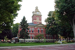
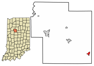
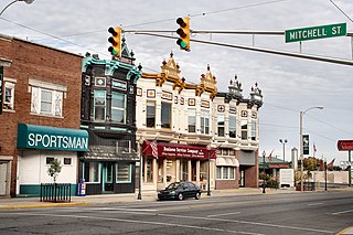
LaGrange County is a county located in the U.S. state of Indiana. As of 2020, the population was 40,446. The county seat is LaGrange, Indiana.

<span class="mw-page-title-main">LaGrange, Arkansas</span> Town in Arkansas, United States

LaGrange is a town in Lee County, Arkansas, United States. The population was 89 at the 2010 census, down from 122 at the 2000 census.

<span class="mw-page-title-main">Burlington, Indiana</span> Town in Indiana, United States

Burlington is a town in Burlington Township, Carroll County, Indiana, United States. The population was 603 at the 2010 census. It is part of the Lafayette, Indiana Metropolitan Statistical Area. State Road 22 connects it to Kokomo.

<span class="mw-page-title-main">Brownstown, Indiana</span> Town in Indiana, United States

Brownstown is a town within Brownstown Township and the county seat of Jackson County, Indiana, United States. The population was 2,947 at the 2010 census. It was named for Jacob Brown, a general of the War of 1812.

<span class="mw-page-title-main">Shipshewana, Indiana</span> Town and Census designated place in Indiana, United States

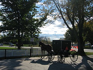
Shipshewana is a town in Newbury Township, LaGrange County, Indiana, United States. The population was 658 at the 2010 census. It is the location of the Menno-Hof Amish & Mennonite Museum, which showcases the history of the Amish and Mennonite peoples.

<span class="mw-page-title-main">Topeka, Indiana</span> Town in Indiana, United States

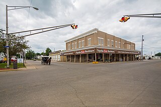
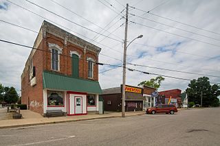
Topeka is a town in Clearspring and Eden townships, LaGrange County, Indiana, United States. The population was 1,153 at the 2010 census. Topeka is located approximately eleven miles south of Shipshewana, Indiana.

<span class="mw-page-title-main">Wolcottville, Indiana</span> Town in Indiana, United States

Wolcottville is a town in Orange Township, Noble County and Johnson Township, LaGrange County in the U.S. state of Indiana. The population was 998 at the 2010 census.

<span class="mw-page-title-main">Kingsbury, Indiana</span> Town in Indiana, United States

Kingsbury is a town in Washington Township, LaPorte County, Indiana, just northwest of the intersection of U.S. Route 35 and U.S. Route 6. The town was founded in 1835 and incorporated on March 3, 1941. During 1940 - 1941, the Kingsbury Ordnance Plant (KOP) was built for use during World War II. The plant closed after the war but reopened during the Korean War, closing permanently in 1959. The population was 242 at the 2010 census. It is included in the Michigan City, Indiana-La Porte, Indiana Metropolitan Statistical Area. The town has its own fire department, KVFD, and a Greek revival style First Baptist church built in 1851 with its own graveyard and Winchell Cemetery.

<span class="mw-page-title-main">Ingalls, Indiana</span> Town in Indiana, United States

Ingalls is a town in Green Township, Madison County, Indiana, United States. It is part of the Indianapolis–Carmel–Anderson metropolitan statistical area. The population was 2,223 at the 2020 census.

<span class="mw-page-title-main">Shoals, Indiana</span> Town in Indiana, United States

Shoals is a town in Center and Halbert townships and the county seat of Martin County, in the U.S. state of Indiana. The population was 677 at the 2020 census, down from 756 in 2010.

<span class="mw-page-title-main">Albion, Indiana</span> Town in Indiana, United States

Albion is a town in Albion and Jefferson townships, Noble County, in the U.S. state of Indiana. The population was 2,349 at the 2010 census. The city is the county seat of Noble County.

<span class="mw-page-title-main">Cromwell, Indiana</span> Town in Indiana, United States

Cromwell is a town in Sparta Township, Noble County, in the U.S. state of Indiana. The population was 512 at the 2010 census.

<span class="mw-page-title-main">Kendallville, Indiana</span> City in Indiana, United States

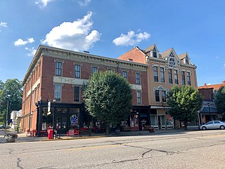
Kendallville is a city in Wayne Township, Noble County, in the U.S. state of Indiana. The population was 10,205 at the 2021 census.

<span class="mw-page-title-main">Rome City, Indiana</span> Town in Indiana, United States

Rome City is a town in Orange Township, Noble County, in the U.S. state of Indiana. The population was 1,361 at the 2010 census.

<span class="mw-page-title-main">Versailles, Indiana</span> Town in Indiana, United States

Versailles is a town in Johnson Township, Ripley County, in the U.S. state of Indiana. The population was 2,113 at the 2010 census. The town is the county seat of Ripley County.

<span class="mw-page-title-main">Vevay, Indiana</span> Town in Indiana, United States

Vevay is a town located in Jefferson Township and the county seat of Switzerland County, Indiana, United States, along the Ohio River. The population was 1,741 at the 2020 census.

<span class="mw-page-title-main">Liberty, Indiana</span> Town in Indiana, United States

Liberty is a town in and the county seat of Union County, Indiana, United States, located about 5 miles (8.0 km) west of the state's border with Ohio. The population was 2,000 at the 2020 census.

LaGrange is a town in Penobscot County, Maine, United States. The population was 635 at the 2020 census.

<span class="mw-page-title-main">Monticello, Missouri</span> Village in Missouri, United States

Monticello is a rural village in, and county seat of, Lewis County, Missouri, United States, along the North Fabius River. The population was 104 at the 2020 census, and according to this census, Monticello is the county seat with the smallest population in the State of Missouri. The town is named in honor of President Thomas Jefferson's estate in Virginia. Monticello is part of the Quincy, IL–MO Micropolitan Statistical Area.

<span class="mw-page-title-main">Wayne, West Virginia</span> Town in West Virginia, United States

Wayne is a town in and the county seat of Wayne County, West Virginia, United States. The population was 1,441 at the 2020 census. It is part of the Huntington–Ashland metropolitan area.

References

  1. "2020 U.S. Gazetteer Files". United States Census Bureau. Retrieved March 16, 2022.
  2. 1 2 U.S. Geological Survey Geographic Names Information System: LaGrange, Indiana
  3. 1 2 "U.S. Census website". United States Census Bureau . Retrieved January 31, 2008.
  4. "Find a County". National Association of Counties. Retrieved June 7, 2011.
  5. Counties of LaGrange and Noble, Indiana: Historical and Biographical. F.A. Battey & Company. 1882. p. 111.
  6. Baker, Ronald L. (October 1995). From Needmore to Prosperity: Hoosier Place Names in Folklore and History. Indiana University Press. p. 189. ISBN   978-0-253-32866-3. ...and named for LaGrange County.
  7. The expansion of New England: the spread of New England settlement and institutions to the Mississippi River, 1620-1865 by Lois Kimball Matthews page 201
  8. "National Register Information System". National Register of Historic Places . National Park Service. July 9, 2010.
  9. Lehman, Octavia (September 20, 2014). "Colorful portraits". Kendallville, Indiana: KPCNews. Retrieved March 18, 2017.
  10. "G001 - Geographic Identifiers - 2010 Census Summary File 1". United States Census Bureau. Archived from the original on February 13, 2020. Retrieved July 25, 2015.
  11. "Census of Population and Housing". Census.gov. Retrieved June 4, 2015.
  12. "U.S. Census website". United States Census Bureau . Retrieved October 19, 2021.
  13. "U.S. Census website". United States Census Bureau . Retrieved December 11, 2012.
  14. "Take a Barons Bus to LaGrange, Indiana". baronsbus.com. April 1, 2018. Retrieved July 14, 2022.
  15. "Homepage". La Grange County Public Library. Retrieved March 8, 2018.