Bloomfield, Indiana

Last updated

Bloomfield, Indiana
Downtown Bloomfield, Indiana.jpg
Buildings in downtown Bloomfield
Greene County Indiana Incorporated and Unincorporated areas Bloomfield Highlighted 1805716.svg
Location of Bloomfield in Greene County, Indiana.
Coordinates: 39°01′34″N86°56′15″W / 39.02611°N 86.93750°W / 39.02611; -86.93750
Country United States
State Indiana
County Greene
Township Richland
Area
[1]
  Total1.41 sq mi (3.65 km2)
  Land1.41 sq mi (3.65 km2)
  Water0.00 sq mi (0.00 km2)
Elevation
[2]
600 ft (200 m)
Population
 (2020)
  Total2,289
  Density1,625.71/sq mi (627.68/km2)
Time zone UTC-5 (EST)
  Summer (DST) UTC-4 (EST)
ZIP code
47424
Area code 812
FIPS code 18-05716
GNIS ID2396592 [2]
Website http://www.bloomfieldin.com/

Bloomfield is a town within Richland Township and the county seat of Greene County, Indiana, United States. [3] The population was 2,405 at the 2010 census.

Contents

Bloomfield is part of the Bloomington, Indiana Metropolitan Statistical Area.

History

The area where Bloomfield is located has been inhabited by Native Americans since prehistory. Tribes that have lived in the area include the Miami tribe, Kickapoo, Piankeshaw and Wea. A settlement of Woodland period people has been excavated by Indiana and Ball State Universities research teams near the confluence of Richland Creek and the White River south of Bloomfield. [4] [5]

The town of Bloomfield was laid out in 1824 when Greene County needed a new county seat due to the lack of a reliable water source for the town of Burlington. Burlington was located west of Bloomfield near the west fork of the White River.

The Greene County Courthouse, a log building in the town's center, was the town's first building. The current Greene County Courthouse, a brick structure built in the late 19th century, stands at the same location. An expansion and renovation project was completed in 2008. It was listed on the National Register of Historic Places in 2008. [6]

In 1824, Peter Cornelius Van Slyke donated land to Greene County for the purpose of establishing a new county seat. [7] Van Slyke was born on the Mohawk River in Schenectady County, New York, on April 5, 1766. He migrated to southern Indiana in 1816. Van Slyke was a veteran of the War of 1812 and died on September 25, 1834.

The well-known Rousseau brothers, Lovell H. Rousseau and Richard H. Rousseau, both located in Bloomfield in 1841 to practice law. They served as Greene County State Representatives and Lovell as State Senator until returning to Kentucky in 1849. During that period, Lovell raised a company of Greene County men (Co. E, 2nd Indiana Infantry) to fight in the Mexican War, who were conspicuous at the Battle of Buena Vista (1847). [8] Following their return to Kentucky, Lovell became nationally famous/distinguished, and the local Bloomfield Chapter of the Grand Army of the Republic was named for him (Post #326). [9]

Bloomfield Jr./Sr. High School has also been home to Indiana Basketball Hall of Fame coaches Guy Glover (1954-1977) and Steve Brett (1978-1993).

Geography

According to the 2010 census, Bloomfield has a total area of 1.38 square miles (3.57 km2), all land. [10]

Demographics

Historical population
CensusPop.Note
1850 234
1870 656
1880 98850.6%
1890 1,22924.4%
1900 1,58829.2%
1910 2,06930.3%
1920 1,872−9.5%
1930 2,29822.8%
1940 2,270−1.2%
1950 2,086−8.1%
1960 2,2246.6%
1970 2,56515.3%
1980 2,7055.5%
1990 2,592−4.2%
2000 2,542−1.9%
2010 2,405−5.4%
2020 2,289−4.8%
Source: U.S. Census Bureau [11]

2010 census

As of the 2010 census, [12] there were 2,405 people, 1,109 households, and 628 families living in the town. The population density was 1,742.8 inhabitants per square mile (672.9/km2). There were 1,263 housing units at an average density of 915.2 per square mile (353.4/km2). The racial makeup of the town was 98.0% White, 0.5% African American, 0.6% Asian, 0.1% from other races, and 0.7% from two or more races. Hispanic or Latino of any race were 1.3% of the population.

There were 1,109 households, of which 29.7% had children under the age of 18 living with them, 40.3% were married couples living together, 12.9% had a female householder with no husband present, 3.4% had a male householder with no wife present, and 43.4% were non-families. 40.2% of all households were made up of individuals, and 18.7% had someone living alone who was 65 years of age or older. The average household size was 2.16 and the average family size was 2.89.

The median age in the town was 39.7 years. 24.5% of residents were under the age of 18; 8.3% were between the ages of 18 and 24; 24.3% were from 25 to 44; 24.5% were from 45 to 64; and 18.5% were 65 years of age or older. The gender makeup of the town was 46.9% male and 53.1% female.

2000 census

As of the 2000 census, [13] there were 2,542 people, 1,180 households, and 665 families living in the town. The population density was 1,841.1 inhabitants per square mile (710.9/km2). There were 1,315 housing units at an average density of 952.4 per square mile (367.7/km2). The racial makeup of the town was 98.31% White, 0.20% African American, 0.08% Native American, 0.43% Asian, 0.31% from other races, and 0.67% from two or more races. Hispanic or Latino of any race were 1.10% of the population.

There were 1,180 households, out of which 23.6% had children under the age of 18 living with them, 43.6% were married couples living together, 10.3% had a female householder with no husband present, and 43.6% were non-families. 40.5% of all households were made up of individuals, and 18.9% had someone living alone who was 65 years of age or older. The average household size was 2.06 and the average family size was 2.76.

In the town, the population was spread out, with 20.8% under the age of 18, 8.5% from 18 to 24, 26.2% from 25 to 44, 22.7% from 45 to 64, and 21.7% who were 65 years of age or older. The median age was 41 years. For every 100 females, there were 91.0 males. For every 100 females age 18 and over, there were 87.2 males.

The median income for a household in the town was $30,224, and the median income for a family was $42,656. Males had a median income of $31,864 versus $23,879 for females. The per capita income for the town was $18,045. About 12.0% of families and 16.6% of the population were below the poverty line, including 21.2% of those under age 18 and 11.8% of those age 65 or over.

Education

Arts and culture

The Richland-Plummer Creek Bridge Richland-Plummer Creek Covered Bridge, southern side and eastern end.jpg
The Richland-Plummer Creek Bridge
Part of the Osborn Site, an archaeological site west of Bloomfield Osborn Site near Bloomfield.jpg
Part of the Osborn Site, an archaeological site west of Bloomfield
Bloomfield law enforcement officers (Deputy Sheriff Lem Clark, center) with the Indiana State Police circa 1940 Bloomfield Indiana Police with Indiana State Police circa 1948.jpg
Bloomfield law enforcement officers (Deputy Sheriff Lem Clark, center) with the Indiana State Police circa 1940

Festivals

Notable people

Related Research Articles

<span class="mw-page-title-main">Morrow County, Ohio</span> County in Ohio, United States

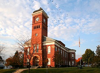
Morrow County is a county located in the central portion of the U.S. state of Ohio. As of the 2020 census, the population was 34,950. Its county seat is Mount Gilead. The county was organized in 1848 from parts of four neighboring counties and named for Jeremiah Morrow who was the Governor of Ohio from 1822 to 1826. Shawnee people used the area for hunting purposes before white settlers arrived in the early 19th century.

<span class="mw-page-title-main">Logan County, Ohio</span> County in Ohio, United States

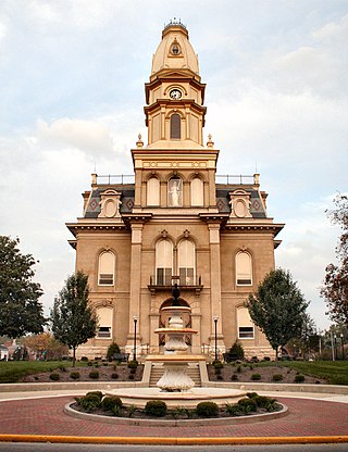
Logan County is a county in the west central portion of the U.S. state of Ohio. As of the 2020 census, the population was 46,150. The county seat is Bellefontaine. The county is named for Benjamin Logan, who fought Native Americans in the area.

<span class="mw-page-title-main">Greene County, Indiana</span> County in Indiana, United States

Greene County is a county in the U.S. state of Indiana. As of 2020, the population was 30,803. The county seat is Bloomfield. The county was determined by the US Census Bureau to include the mean center of U.S. population in 1930.

<span class="mw-page-title-main">Earl Park, Indiana</span> Town in Indiana, United States

Earl Park is a town in Richland Township, Benton County, Indiana, United States. The population was 348 at the 2010 census. It is part of the Lafayette, Indiana Metropolitan Statistical Area.

<span class="mw-page-title-main">Corunna, Indiana</span> Town in Indiana, United States

Corunna is a town in Richland Township, DeKalb County, Indiana, United States. The population was 236 at the 2020 census estimate.

<span class="mw-page-title-main">Mellott, Indiana</span> Town in Indiana, United States

Mellott is a town in Richland Township, Fountain County, Indiana, United States. The population was 197 at the 2010 census.

<span class="mw-page-title-main">Converse, Indiana</span> Town in Indiana, United States

Converse is a town in Jackson Township, Miami County, and Richland Township, Grant County, in the U.S. state of Indiana. The population was 1,161 at the 2020 census.

<span class="mw-page-title-main">Lyons, Indiana</span> Town in Indiana, United States

Lyons is a town in Washington Township, Greene County, Indiana, United States. The population was 742 at the 2010 census. It is part of the Bloomington, Indiana Metropolitan Statistical Area.

<span class="mw-page-title-main">Switz City, Indiana</span> Town in Indiana, United States

Switz City is a town in Fairplay and Grant townships, Greene County, Indiana, United States. The population was 293 at the 2010 census. It is part of the Bloomington, Indiana, Metropolitan Statistical Area.

<span class="mw-page-title-main">Worthington, Indiana</span> Town in Indiana, United States

Worthington is a town in Jefferson Township, Greene County, Indiana, United States. The population was 1,463 at the 2010 United States Census. It is part of the Bloomington, Indiana, Metropolitan Statistical Area.

<span class="mw-page-title-main">Wilkinson, Indiana</span> Town in Indiana, United States

Wilkinson is a town in Brown Township, Hancock County, Indiana, United States. The population was 449 at the 2010 census.

<span class="mw-page-title-main">Bloomingdale, Indiana</span> Town in Indiana, United States

Bloomingdale is a town in Penn Township, Parke County, in the U.S. state of Indiana. The population was 335 at the 2010 census.

<span class="mw-page-title-main">Shawnee, Kansas</span> City in Kansas, United States

Shawnee is a city in Johnson County, Kansas, United States. It is the seventh most populous municipality in the Kansas City metropolitan area. As of the 2020 census, the population of the city was 67,311.

<span class="mw-page-title-main">New Bloomfield, Missouri</span> City in Missouri, United States

New Bloomfield is a city in Cedar Township, Callaway County, Missouri, United States. The population was 669 at the 2010 census. It is part of the Jefferson City Metropolitan Statistical Area.

<span class="mw-page-title-main">Richlands, North Carolina</span> Town in North Carolina, United States

Richlands is a town in Onslow County, North Carolina, United States. In the 2020 U.S. census, the population was 2,287. It is included in the Jacksonville, North Carolina Metropolitan Statistical Area. Incorporated on March 29, 1880, it was the first town in Onslow County to have its own library and museum. Richlands was also the first town in Onslow County to have a female mayor, Annette Hargett.

<span class="mw-page-title-main">Greenville, Ohio</span> City in Ohio, United States

Greenville is a city in and the county seat of Darke County, Ohio, United States. It is located near Ohio's western edge, about 33 miles (53 km) northwest of Dayton. The population was 12,786 at the 2020 census.

<span class="mw-page-title-main">Shawnee Hills, Greene County, Ohio</span> Census-designated place in Ohio, United States

Shawnee Hills is a census-designated place (CDP) in Greene County, Ohio, United States. Shawnee Hills consists of a planned community centered on the 250-acre (1.0 km2) Shawnee Lake. The population was 2,230 at the 2020 census. It is part of the Dayton Metropolitan Statistical Area, and should not be confused with the incorporated village of Shawnee Hills in Delaware County.

<span class="mw-page-title-main">Richland, Pennsylvania</span> Borough in Pennsylvania, United States

Richland is a borough in Lebanon County, Pennsylvania. It is part of the Lebanon County, Pennsylvania metropolitan statistical area. The population was 1,490 at the 2020 census.

<span class="mw-page-title-main">Richland Township, Greene County, Indiana</span> Township in Indiana, United States

Richland Township is one of fifteen townships in Greene County, Indiana, USA. As of the 2020 census, its population was 4,675, down from 5,019 at 2010.

<span class="mw-page-title-main">Richland, Spencer County, Indiana</span> Town in Indiana, United States

Richland is a town in Luce Township, Spencer County, in the U.S. state of Indiana. Until 2008, it was an unincorporated community; the town's residents voted to incorporate in the November 2008 general election. The population was 403 at the 2020 census.

References

  1. "2020 U.S. Gazetteer Files". United States Census Bureau. Retrieved March 16, 2022.
  2. 1 2 U.S. Geological Survey Geographic Names Information System: Bloomfield, Indiana
  3. "Find a County". National Association of Counties. Archived from the original on May 31, 2011. Retrieved June 7, 2011.
  4. "Introduction to the Prehistory of Indiana". Kellar, James H. Archived from the original on September 9, 2012. Retrieved January 23, 2013.
  5. "Patterns in lithic resource procurement and exploitation among early paleo-Indians of the midwestern United States". Tankersley, Kenneth B. Archived from the original on February 7, 2012. Retrieved January 23, 2013.
  6. 1 2 "National Register Information System". National Register of Historic Places . National Park Service. July 9, 2010.
  7. "Greene County Indiana History and Genealogy". County History Preservation Society. Archived from the original on February 5, 2012. Retrieved January 23, 2013.
  8. 1 2 Lee, Dan (2010). Kentuckian in Blue: A Biography of Major General Lovell Harrison Rousseau. McFarland.
  9. "Indiana GAR Posts 300 thru 399 – Department of Indiana" . Retrieved February 25, 2024.
  10. "G001 - Geographic Identifiers - 2010 Census Summary File 1". United States Census Bureau. Archived from the original on February 13, 2020. Retrieved July 13, 2015.
  11. "Indiana City/Town Census Counts, 1900 to 2010". STATS Indiana. Indiana Business Research Center . Retrieved June 30, 2014.
  12. "U.S. Census website". United States Census Bureau . Retrieved December 11, 2012.
  13. "U.S. Census website". United States Census Bureau . Retrieved January 31, 2008.
  14. "Indiana public library directory" (PDF). Indiana State Library. Archived from the original (PDF) on February 18, 2017. Retrieved March 7, 2018.
  15. https://web.archive.org/web/20161227124913/http://library.courtinfo.ca.gov/included/docs/SCJC_Vol_1.pdf. Archived from the original (PDF) on December 27, 2016. Retrieved February 25, 2024.{{cite web}}: Missing or empty |title= (help)
  16. "Indiana Politicians By Letter". Capitol & Washington. March 6, 2015. Retrieved February 25, 2024.
  17. "Indiana Politicians By Letter". Capitol & Washington. March 6, 2015. Retrieved February 25, 2024.