Winchester, Indiana

Last updated

Winchester
City of Winchester
Randolph County Courthouse and monument.jpg
Randolph County Courthouse and veterans' monument in downtown Winchester
Nickname(s): 
Dub – C (WC), Sugar Cream Pie Capital
Randolph County Indiana Incorporated and Unincorporated areas Winchester Highlighted 1884752.svg
Location of Winchester in Randolph County, Indiana.
Winchester, Indiana from the air.jpg
Birds-eye view of Winchester
Coordinates: 40°10′19″N84°58′35″W / 40.17194°N 84.97639°W / 40.17194; -84.97639
Country United States
State Indiana
County Randolph
Township White River
Named for Winchester, Hampshire
Government
   Mayor Robert (Bob) McCoy (R)[ citation needed ]
Area
[1]
  Total3.47 sq mi (8.99 km2)
  Land3.46 sq mi (8.96 km2)
  Water0.01 sq mi (0.03 km2)
Elevation
[2]
1,093 ft (333 m)
Population
 (2020)
  Total4,843
  Density1,400.12/sq mi (540.66/km2)
Time zone UTC-5 (EST)
  Summer (DST) UTC-4 (EDT)
ZIP code
47394
Area code 765
FIPS code 18-84752 [3]
GNIS feature ID2397335 [2]
Website www.winchester-in.gov

Winchester is a city in White River Township, Randolph County, in the U.S. state of Indiana. The city is the county seat of Randolph County. [2] The population was 4,935 at the 2010 census. [4] It is the home of Winchester Speedway.

Contents

History

Winchester was laid out in 1818 as the county seat. [5] A post office has been in operation at Winchester since 1820. [6]

With the discovery of oil in the late 1800s, Winchester became a center for the glass industry. [7]

The Gen. Asahel Stone Mansion, Winchester Courthouse Square Historic District, and Winchester Residential Historic District are listed on the National Register of Historic Places. [8] [9]

2024 tornado

At 7:58pm on March 14, 2024, a quarter-mile wide EF3 tornado hit Winchester during a severe weather outbreak. [10] Severe damage was dealt to the Goodwill, The Lodge at Summers Pointe, and Strip Mall. The Freedom Life Church and Taco Bell were flattened. Thirty-eight were injured and three were left critically injured; one of the three died 5 weeks later.

Geography

According to the 2010 census, Winchester has a total area of 3.343 square miles (8.66 km2), of which 3.33 square miles (8.62 km2) (or 99.61%) is land and 0.013 square miles (0.03 km2) (or 0.39%) is water. [11]

Demographics

Historical population
CensusPop.Note
1850 532
1870 1,456
1880 1,95834.5%
1890 3,01453.9%
1900 3,70522.9%
1910 4,26615.1%
1920 4,021−5.7%
1930 4,48711.6%
1940 5,30318.2%
1950 5,4673.1%
1960 5,7425.0%
1970 5,493−4.3%
1980 5,6593.0%
1990 5,095−10.0%
2000 5,037−1.1%
2010 4,935−2.0%
2020 4,843−1.9%
U.S. Decennial Census [12]

2010 census

At the 2010 census there were 4,935 people, 2,051 households, and 1,281 families living in the city. The population density was 1,482.0 inhabitants per square mile (572.2/km2). There were 2,349 housing units at an average density of 705.4 per square mile (272.4/km2). The racial makeup of the city was 96.1% White, 0.5% African American, 0.5% Native American, 0.5% Asian, 1.3% from other races, and 1.1% from two or more races. Hispanic or Latino of any race were 2.6%. [13]

Of the 2,051 households 30.2% had children under the age of 18 living with them, 43.1% were married couples living together, 14.3% had a female householder with no husband present, 5.0% had a male householder with no wife present, and 37.5% were non-families. 32.2% of households were one person and 14.9% were one person aged 65 or older. The average household size was 2.32 and the average family size was 2.89.

The median age was 40.2 years. 23.6% of residents were under the age of 18; 8.3% were between the ages of 18 and 24; 23.8% were from 25 to 44; 25.4% were from 45 to 64; and 18.9% were 65 or older. The gender makeup of the city was 47.6% male and 52.4% female.

2000 census

At the 2000 census there were 5,037 people, 2,171 households, and 1,350 families living in the city. The population density was 1,623.8 inhabitants per square mile (627.0/km2). There were 2,377 housing units at an average density of 766.3 per square mile (295.9/km2). The racial makeup of the city was 98.31% White, 0.24% African American, 0.26% Native American, 0.30% Asian, 0.32% from other races, and 0.58% from two or more races. Hispanic or Latino of any race were 1.41%. [3]

Of the 2,171 households 27.4% had children under the age of 18 living with them, 48.1% were married couples living together, 10.5% had a female householder with no husband present, and 37.8% were non-families. 33.7% of households were one person, and 16.2% were one person aged 65 or older. The average household size was 2.23 and the average family size was 2.83.

In the city the population was spread out, with 22.2% under the age of 18, 8.9% from 18 to 24, 27.4% from 25 to 44, 22.0% from 45 to 64, and 19.6% 65 or older. The median age was 40 years. For every 100 females, there were 88.7 males. For every 100 females age 18 and over, there were 84.9 males.

The median household income was $28,500 and the median family income was $37,607. Males had a median income of $28,947 versus $22,226 for females. The per capita income for the city was $17,753. About 10.9% of families and 15.0% of the population were below the poverty line, including 20.2% of those under age 18 and 6.9% of those age 65 or over.

Education

The town has a lending library, the Winchester Community Public Library. [14]

Schools, all part of the Randolph Central School Corporation public school district, include: [15] [16]

Notable people

Related Research Articles

<span class="mw-page-title-main">Randolph County, Indiana</span> County in Indiana, United States

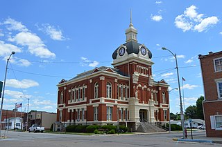
Randolph County is a county located in the central section of U.S. state of Indiana, on its eastern border with Ohio. As of 2020, the population was 24,502. The county seat is Winchester.

<span class="mw-page-title-main">Gassville, Arkansas</span> City in Arkansas, United States

Gassville is a city in Baxter County, Arkansas, United States. According to the 2020 census, the city population was 2,171.

<span class="mw-page-title-main">Winchester, Illinois</span> City in Illinois, United States

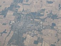
Winchester is a city in and the county seat of Scott County, Illinois, United States. The population was 1,593 at the 2010 census. Winchester is part of the Jacksonville Micropolitan Statistical Area.

<span class="mw-page-title-main">Rising Sun, Indiana</span> City in Indiana, United States

Rising Sun is a city in Randolph Township and the county seat of Ohio County, Indiana, United States, along the Ohio River. It is also the only incorporated community in the county. The population of Rising Sun was 2,304 at the 2010 census.

<span class="mw-page-title-main">Lynn, Indiana</span> Town in Indiana, United States

Lynn is a town in Washington Township, Randolph County, in the U.S. state of Indiana. The population was 1,097 at the 2010 census.

<span class="mw-page-title-main">Modoc, Indiana</span> Town in Indiana, United States

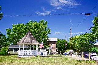
Modoc is a town in Union Township, Randolph County, in the U.S. state of Indiana. The population was 196 at the 2010 census.

<span class="mw-page-title-main">Parker City, Indiana</span> Town in Indiana, United States

Parker City is a town in Monroe Township, Randolph County, in the U.S. state of Indiana. The population was 1,419 at the 2010 census.

<span class="mw-page-title-main">Ridgeville, Indiana</span> Town in Indiana, United States

Ridgeville is a town in Franklin Township, Randolph County, Indiana, United States, along the Mississinewa River. The population was 688 at the 2020 census.

<span class="mw-page-title-main">Saratoga, Indiana</span> Town in Indiana, United States

Saratoga is a town in Ward Township, Randolph County, in the U.S. state of Indiana. The population was 254 at the 2010 census.

<span class="mw-page-title-main">Union City, Indiana</span> City in Indiana, United States

Union City is a city in Wayne Township, Randolph County, Indiana, United States. As of the 2020 census, the city had a population of 3,454.

<span class="mw-page-title-main">Winchester, Kansas</span> City in Kansas, United States

Winchester is a city in Jefferson County, Kansas, United States. As of the 2020 census, the population of the city was 461.

<span class="mw-page-title-main">Chisago City, Minnesota</span> City in Minnesota, United States

Chisago City is a city in Chisago County, Minnesota, United States, approximately 35 miles northeast of downtown Minneapolis–Saint Paul. The population was 4,967 at the 2010 census.

<span class="mw-page-title-main">Randolph, Minnesota</span> City in Minnesota, United States

Randolph is a city in Dakota County, Minnesota, United States. The population was 436 at the 2010 census.

<span class="mw-page-title-main">Randolph, Missouri</span> City in Missouri, United States

Randolph is a city in Clay County, Missouri, United States. The population was 57 at the 2020 census. It is completely surrounded by Kansas City and is a part of the Kansas City metropolitan area.

<span class="mw-page-title-main">Randolph, Nebraska</span> City in Nebraska, United States

Randolph is a city in Cedar County, Nebraska, United States. The population was 881 at the 2020 census. It refers to itself as "The Honey Capital of the Nation" due to the per-capita number of bee keeping families.

<span class="mw-page-title-main">Clayton, Ohio</span> City in Ohio, United States

Clayton is a city in Montgomery County, Ohio, United States. The population was 13,310 at the 2020 census. A suburb of Dayton, it is part of the Dayton metropolitan area.

<span class="mw-page-title-main">Fairfield Township, Westmoreland County, Pennsylvania</span> Township in Pennsylvania, United States

Fairfield Township is a township in Westmoreland County, Pennsylvania, United States. The population was 2,051 at the 2020 census.

<span class="mw-page-title-main">Randolph, Maine</span> Town in the state of Maine, United States

Randolph is a town and a census-designated place (CDP) in Kennebec County, Maine, United States. The population was 1,743 at the 2020 census. The town was named for Randolph, Massachusetts. Randolph is included in the Augusta, Maine micropolitan New England City and Town Area.

<span class="mw-page-title-main">Randolph, Wisconsin</span> Village in Wisconsin, United States

Randolph is a village in Columbia and Dodge Counties in the U.S. state of Wisconsin. The population was 1,811 at the 2010 census. Of this, 1,339 were in Dodge County, and 472 were in Columbia County. The village is located at the southeast corner of the Town of Randolph in Columbia County, although only a tiny portion of the village lies within the town. Most of the village lies within the Town of Westford in Dodge County. Small portions also lie within the Town of Fox Lake to the north and the Town of Courtland in Columbia County.

<span class="mw-page-title-main">Waterford, Wisconsin</span> Village in Wisconsin, United States

Waterford is a village in Racine County, Wisconsin, United States. The population was 5,542 at the 2020 census.

References

  1. "2020 U.S. Gazetteer Files". United States Census Bureau. Retrieved March 16, 2022.
  2. 1 2 3 U.S. Geological Survey Geographic Names Information System: Winchester, Indiana
  3. 1 2 "U.S. Census website". United States Census Bureau . Retrieved January 31, 2008.
  4. "Find a County". National Association of Counties. Retrieved June 7, 2011.
  5. Tucker, E. (1882). History of Randolph County, Indiana: With Illustrations and Biographical Sketches of Some of Its Prominent Men and Pioneers : to which are Appended Maps of Its Several Townships. A.L. Klingman. p. 36.
  6. "Randolph County". Jim Forte Postal History. Retrieved November 1, 2015.
  7. "Randolph County Indiana – A Brief History". Randolph County Historical Society. Retrieved June 3, 2023.
  8. "National Register Information System". National Register of Historic Places . National Park Service. July 9, 2010.
  9. "National Register of Historic Places Listings". Weekly List of Actions Taken on Properties: 3/21/11 through 3/25/11. National Park Service. April 1, 2011.
  10. Helsel, Phil; Cradduck, Josh; Prociv, Kathryn; Burke, Minyvonne (March 14, 2024). "Tornadoes leave at least 3 dead in Ohio and flatten buildings in Indiana". Weather. NBC News . Retrieved March 15, 2024.
  11. "G001 – Geographic Identifiers – 2010 Census Summary File 1". United States Census Bureau. Archived from the original on February 13, 2020. Retrieved July 29, 2015.
  12. "Census of Population and Housing". Census.gov. Retrieved June 4, 2015.
  13. "U.S. Census website". United States Census Bureau . Retrieved December 11, 2012.
  14. "Indiana public library directory" (PDF). Indiana State Library. Retrieved March 14, 2018.
  15. "Search for Public Schools – Willard Elementary School (180177000241)". National Center for Education Statistics . Institute of Education Sciences . Retrieved April 25, 2023.
  16. "Willard Elementary School (7145)". INview. Indiana Department of Education . Retrieved April 25, 2023.