Farmland, Indiana | |
---|---|
Coordinates: 40°11′25″N85°07′28″W / 40.19028°N 85.12444°W | |
Country | United States |
State | Indiana |
County | Randolph |
Township | Monroe |
Area | |
• Total | 0.53 sq mi (1.38 km2) |
• Land | 0.53 sq mi (1.38 km2) |
• Water | 0.00 sq mi (0.00 km2) |
Elevation | 1,027 ft (313 m) |
Population (2020) | |
• Total | 1,270 |
• Density | 2,391.71/sq mi (923.60/km2) |
Time zone | UTC-5 (EST) |
• Summer (DST) | UTC-5 (EST) |
ZIP code | 47340 |
Area code | 765 |
FIPS code | 18-22792 [3] |
GNIS feature ID | 2396935 [2] |
Website | http://www.farmlandindiana.org |
Farmland is a town in Monroe Township, Randolph County, in the U.S. state of Indiana. [2] The population was 1,333 at the 2010 census.
The Randolph County location has rolling hills, glacial features, and the Cabin Creek Raised Bog. Farmland was platted in 1852 when the railroad was extended to that point. [4] The town most likely was so named on account of their fertile soil. [5] A post office has been in operation at Farmland since 1853. [6] Farmland was incorporated as a town in 1867. [7]
The Farmland Downtown Historic District was listed on the National Register of Historic Places in 1994. [8]
A sign posted by the state highway department welcomes people to Farmland and notes that it is "The Home of Ansel Toney, The Kite Man". [9]
According to the 2010 census, Farmland has a total area of 0.53 square miles (1.37 km2), all land. [10]
Census | Pop. | Note | %± |
---|---|---|---|
1870 | 532 | — | |
1880 | 661 | 24.2% | |
1890 | 770 | 16.5% | |
1900 | 870 | 13.0% | |
1910 | 907 | 4.3% | |
1920 | 878 | −3.2% | |
1930 | 853 | −2.8% | |
1940 | 914 | 7.2% | |
1950 | 943 | 3.2% | |
1960 | 1,102 | 16.9% | |
1970 | 1,262 | 14.5% | |
1980 | 1,560 | 23.6% | |
1990 | 1,412 | −9.5% | |
2000 | 1,456 | 3.1% | |
2010 | 1,333 | −8.4% | |
2020 | 1,270 | −4.7% | |
U.S. Decennial Census [11] |
As of the census [12] of 2010, there were 1,333 people, 543 households, and 375 families living in the town. The population density was 2,515.1 inhabitants per square mile (971.1/km2). There were 612 housing units at an average density of 1,154.7 per square mile (445.8/km2). The racial makeup of the town was 97.3% White, 0.2% African American, 1.4% Native American, 0.1% Asian, 0.2% from other races, and 1.0% from two or more races. Hispanic or Latino of any race were 1.1% of the population.
There were 543 households, of which 32.6% had children under the age of 18 living with them, 52.5% were married couples living together, 13.3% had a female householder with no husband present, 3.3% had a male householder with no wife present, and 30.9% were non-families. 26.3% of all households were made up of individuals, and 12.2% had someone living alone who was 65 years of age or older. The average household size was 2.45 and the average family size was 2.94.
The median age in the town was 39.3 years. 24.4% of residents were under the age of 18; 8.1% were between the ages of 18 and 24; 24.8% were from 25 to 44; 27.1% were from 45 to 64; and 15.8% were 65 years of age or older. The gender makeup of the town was 48.0% male and 52.0% female.
As of the census [3] of 2000, there were 1,456 people, 573 households, and 414 families living in the town. The population density was 2,898.1 inhabitants per square mile (1,119.0/km2). There were 608 housing units at an average density of 1,210.2 per square mile (467.3/km2). The racial makeup of the town was 98.49% White, 0.48% Native American, 0.07% Asian, 0.07% from other races, and 0.89% from two or more races. Hispanic or Latino of any race were 0.21% of the population.
There were 573 households, out of which 34.4% had children under the age of 18 living with them, 58.3% were married couples living together, 10.5% had a female householder with no husband present, and 27.7% were non-families. 23.7% of all households were made up of individuals, and 11.2% had someone living alone who was 65 years of age or older. The average household size was 2.54 and the average family size was 3.03.
In the town, the population was spread out, with 28.0% under the age of 18, 6.7% from 18 to 24, 28.4% from 25 to 44, 21.0% from 45 to 64, and 15.9% who were 65 years of age or older. The median age was 36 years. For every 100 females, there were 92.3 males. For every 100 females age 18 and over, there were 86.0 males.
The median income for a household in the town was $36,250, and the median income for a family was $45,000. Males had a median income of $31,795 versus $21,750 for females. The per capita income for the town was $18,405. About 3.4% of families and 6.5% of the population were below the poverty line, including 7.4% of those under age 18 and 3.5% of those age 65 or over.
The town has a lending library, the Farmland Public Library. [13]
Albany is a town in Delaware and Randolph counties in the U.S. state of Indiana, along the Mississinewa River. The population was 2,295 at the 2020 census. It is part of the Muncie, IN Metropolitan Statistical Area.
Coatesville is a town in Clay Township, Hendricks County, Indiana, United States. The population was 523 at the 2010 Census.
North Salem is a town in Eel River Township, Hendricks County, Indiana, United States. The population was 518 at the 2010 Census.
Mooreland is a town in Blue River Township, Henry County, Indiana, United States. The population was 375 at the 2010 census.
Remington is a town in Carpenter Township, Jasper County, Indiana, United States. The population was 1,185 at the 2010 census.
Paragon is a town in Ray Township, Morgan County, in the U.S. state of Indiana. The population was 556 at the 2020 census, down from 659 in 2010.
Ligonier is a city in Perry Township, Noble County, in the U.S. state of Indiana. The population was 4,568 at the 2020 census.
Losantville is a town in Union Township, Randolph County, in the U.S. state of Indiana. The population was 237 at the 2010 census.
Modoc is a town in Union Township, Randolph County, in the U.S. state of Indiana. The population was 196 at the 2010 census.
Parker City is a town in Monroe Township, Randolph County, in the U.S. state of Indiana. The population was 1,419 at the 2010 census.
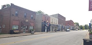
Ridgeville is a town in Franklin Township, Randolph County, Indiana, United States, along the Mississinewa River. The population was 688 at the 2020 census.
Saratoga is a town in Ward Township, Randolph County, in the U.S. state of Indiana. The population was 254 at the 2010 census.
Winchester is a city in White River Township, Randolph County, in the U.S. state of Indiana. The city is the county seat of Randolph County. The population was 4,935 at the 2010 census. It is the home of Winchester Speedway.
Clear Lake is a town located in the northeast corner of Steuben County, Indiana, in Clear Lake Township. As such, is the northeasternmost community in the State of Indiana. The population was 339 at the 2010 census.
Clarks Hill is a town in Lauramie Township, Tippecanoe County, in the U.S. state of Indiana. The population was 611 at the 2010 census.
Mabscott is a town in Raleigh County, West Virginia, United States. The population was 1,333 at the 2020 census. The town's name is a contraction of the name Mabel Scott, wife of local coal operator Cyrus H. Scott.
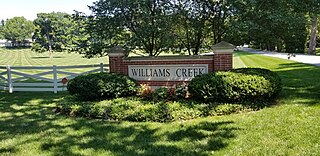
Williams Creek is a town in Washington Township, Marion County, Indiana, United States. It is located about 9 miles (14 km) north of downtown Indianapolis. The population was 430 at the 2020 census. It has existed as an "included town" since 1970, when it was incorporated into Indianapolis as part of Unigov. It is part of Indianapolis, but retains a functioning town government under IC 36-3-1-11.
Randolph is a town and a census-designated place (CDP) in Kennebec County, Maine, United States. The population was 1,743 at the 2020 census. The town was named for Randolph, Massachusetts. Randolph is included in the Augusta, Maine micropolitan New England City and Town Area.
Randolph is a village in Columbia and Dodge Counties in the U.S. state of Wisconsin. The population was 1,811 at the 2010 census. Of this, 1,339 were in Dodge County, and 472 were in Columbia County. The village is located at the southeast corner of the Town of Randolph in Columbia County, although only a tiny portion of the village lies within the town. Most of the village lies within the Town of Westford in Dodge County. Small portions also lie within the Town of Fox Lake to the north and the Town of Courtland in Columbia County.
Hagerstown is a town in Jefferson Township, Wayne County, in the U.S. state of Indiana. As of the 2020 census, the population was 1,681.
...presumably named for the rich farmland surrounding it.