Modoc, Indiana

Last updated

Modoc, Indiana
Town of Modoc
Modoc, Indiana.jpg
Flag of Indiana.svg
Nickname: 
Small Town U.S.A
Randolph County Indiana Incorporated and Unincorporated areas Modoc Highlighted 1850058.svg
Location of Modoc in Randolph County, Indiana.
Coordinates: 40°02′45″N85°07′30″W / 40.04583°N 85.12500°W / 40.04583; -85.12500
Country United States
State Indiana
County Randolph
Township Union
Founded1883
Area
[1]
  Total0.10 sq mi (0.27 km2)
  Land0.10 sq mi (0.27 km2)
  Water0.00 sq mi (0.00 km2)
Elevation
[2]
1,175 ft (358 m)
Population
 (2020)
  Total157
  Density1,524.27/sq mi (586.67/km2)
Time zone UTC-5 (EST)
  Summer (DST) UTC-5 (EST)
ZIP code
47358
Area code 765
Major Highways U.S. Highway 36
Indiana State Highway 1
FIPS code 18-50058 [3]
GNIS feature ID2396769 [2]

Modoc is a town in Union Township, Randolph County, in the U.S. state of Indiana. [2] The population was 196 at the 2010 census.

Contents

Modoc from above Modoc-indiana-from-above.jpg
Modoc from above

History

There are several legends to how the town of Modoc got its name. One of them said that a man travelling on the train threw out a cigar box containing the name Modoc, and that Henry Conley, one of the first settlers of the town, picked it up and suggested to bystanders that it would be a good name for the town. Another theory is that Modoc was named after the Modoc people who were traditionally located in northern California. [4] They became noted for their resistance to the US Army during the Modoc War, ending in 1873.

A post office has been in operation at Modoc since 1883. [5]

Demographics

Historical population
CensusPop.Note
1900 221
1910 26118.1%
1920 256−1.9%
1930 236−7.8%
1940 2370.4%
1950 27516.0%
1960 238−13.5%
1970 27515.5%
1980 243−11.6%
1990 218−10.3%
2000 2253.2%
2010 196−12.9%
2020 157−19.9%
U.S. Decennial Census [6]

2010 census

As of the census [7] of 2010, there were 196 people, 72 households, and 50 families residing in the town. The population density was 1,960.0 inhabitants per square mile (756.8/km2). There were 87 housing units at an average density of 870.0 per square mile (335.9/km2). The racial makeup of the town was 94.9% White, 0.5% African American, 2.0% Pacific Islander, 0.5% from other races, and 2.0% from two or more races. Hispanic or Latino of any race were 1.5% of the population.

There were 72 households, of which 40.3% had children under the age of 18 living with them, 41.7% were married couples living together, 19.4% had a female householder with no husband present, 8.3% had a male householder with no wife present, and 30.6% were non-families. 23.6% of all households were made up of individuals, and 11.1% had someone living alone who was 65 years of age or older. The average household size was 2.72 and the average family size was 3.22.

The median age in the town was 33 years. 30.1% of residents were under the age of 18; 9.2% were between the ages of 18 and 24; 25% were from 25 to 44; 21.4% were from 45 to 64; and 14.3% were 65 years of age or older. The gender makeup of the town was 54.1% male and 45.9% female.

2000 census

As of the census [3] of 2000, there were 225 people, 84 households, and 63 families residing in the town. The population density was 1,908.1 inhabitants per square mile (736.7/km2). There were 90 housing units at an average density of 763.2 per square mile (294.7/km2). The racial makeup of the town was 96.00% White, 1.33% African American, 0.44% Pacific Islander, and 2.22% from two or more races. Hispanic or Latino of any race were 0.89% of the population.

There were 84 households, out of which 39.3% had children under the age of 18 living with them, 57.1% were married couples living together, 14.3% had a female householder with no husband present, and 25.0% were non-families. 22.6% of all households were made up of individuals, and 8.3% had someone living alone who was 65 years of age or older. The average household size was 2.68 and the average family size was 3.06.

In the town, the population was spread out, with 28.9% under the age of 18, 9.3% from 18 to 24, 31.6% from 25 to 44, 19.1% from 45 to 64, and 11.1% who were 65 years of age or older. The median age was 34 years. For every 100 females, there were 108.3 males. For every 100 females age 18 and over, there were 97.5 males.

The median income for a household in the town was $28,333, and the median income for a family was $32,708. Males had a median income of $31,250 versus $24,375 for females. The per capita income for the town was $13,230. About 12.3% of families and 14.6% of the population were below the poverty line, including 14.6% of those under the age of eighteen and 21.9% of those 65 or over.

Geography

Modoc is located about 25 miles southeast of Muncie, Indiana, and is about 25 miles northwest of Richmond, Indiana and 60 miles from the cities of Indianapolis, Indiana, Dayton, Ohio, and Cincinnati.

According to the 2010 census, Modoc has a total area of 0.1 square miles (0.26 km2), all land. [8]

Transportation

Highways

Major highways and roads that serve Modoc include Indiana 1 and U.S. 36

Randolph Farms Landfill

Randolph Farms Landfill is a 120-acre (486,000 m2) landfill owned by the Balkema family of Kalamazoo, Michigan, located in Randolph County, Indiana. In addition to Randolph County, it serves Delaware, Madison, Jay, Wayne, and Henry Counties in Indiana, as well as Darke and Miami Counties in Ohio. Randolph Farms was built on a limestone hill, directly over sand and gravel aquifers, near the drainage basins of White River and Whitewater River.

Education

Modoc's high school is Union High School. The mascot of the school is the Rocket. Their colors are royal blue and gold.

The I. B. & W. Railroad

Modoc, like many other small towns, probably would not have been built if the I. B. & W. Railroad had not made its way across southern Randolph County, in 1878. The location was poorly drained, but it had the advantage of being rather flat. It was plagued, for many years, by typhoid fever outbreaks. The railroad was built by many contractors. The railroad came through Modoc from the west, and met the contractors, who were building the next section east, in what was then a strip of timber about one-half mile east of where the depot was located.

Related Research Articles

<span class="mw-page-title-main">St. Paul, Indiana</span> Town in Indiana, United States

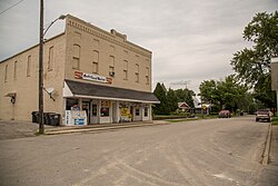
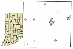
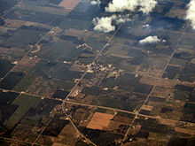
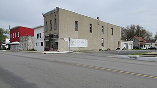
St. Paul or Saint Paul is a small town on the border of Decatur and Shelby counties in the U.S. state of Indiana. The population was 1,031 at the 2010 census.

<span class="mw-page-title-main">Ashley, Indiana</span> Town in Indiana, United States

Ashley is a town in Indiana located on the border of Smithfield Township, DeKalb County and Steuben Township, Steuben County. The population was 983 at the 2010 census.

<span class="mw-page-title-main">Albany, Indiana</span> Town in Indiana, United States

Albany is a town in Delaware and Randolph counties in the U.S. state of Indiana, along the Mississinewa River. The population was 2,295 at the 2020 census. It is part of the Muncie, IN Metropolitan Statistical Area.

<span class="mw-page-title-main">Lyons, Indiana</span> Town in Indiana, United States

Lyons is a town in Washington Township, Greene County, Indiana, United States. The population was 742 at the 2010 census. It is part of the Bloomington, Indiana Metropolitan Statistical Area.

<span class="mw-page-title-main">Andrews, Indiana</span> Town in Indiana, United States

Andrews is a town in Dallas Township, Huntington County, Indiana, United States. The population was 1,048 at the 2020 census.

<span class="mw-page-title-main">Sidney, Indiana</span> Town in Indiana, United States

Sidney is a town in Jackson Township, Kosciusko County, in the U.S. state of Indiana. The population was 83 at the 2010 census.

<span class="mw-page-title-main">Bethany, Indiana</span> Town in Indiana, United States

Bethany is a town in Clay Township, Morgan County, in the U.S. state of Indiana. The population was 95 at the 2020 census.

<span class="mw-page-title-main">Paragon, Indiana</span> Town in Indiana, United States

Paragon is a town in Ray Township, Morgan County, in the U.S. state of Indiana. The population was 556 at the 2020 census, down from 659 in 2010.

<span class="mw-page-title-main">Rising Sun, Indiana</span> City in Indiana, United States

Rising Sun is a city in Randolph Township and the county seat of Ohio County, Indiana, United States, along the Ohio River. It is also the only incorporated community in the county. The population of Rising Sun was 2,304 at the 2010 census.

<span class="mw-page-title-main">Farmland, Indiana</span> Town in Indiana, United States

Farmland is a town in Monroe Township, Randolph County, in the U.S. state of Indiana. The population was 1,333 at the 2010 census.

<span class="mw-page-title-main">Losantville, Indiana</span> Town in Indiana, United States

Losantville is a town in Union Township, Randolph County, in the U.S. state of Indiana. The population was 237 at the 2010 census.

<span class="mw-page-title-main">Lynn, Indiana</span> Town in Indiana, United States

Lynn is a town in Washington Township, Randolph County, in the U.S. state of Indiana. The population was 1,097 at the 2010 census.

<span class="mw-page-title-main">Parker City, Indiana</span> Town in Indiana, United States

Parker City is a town in Monroe Township, Randolph County, in the U.S. state of Indiana. The population was 1,419 at the 2010 census.

<span class="mw-page-title-main">Ridgeville, Indiana</span> Town in Indiana, United States

Ridgeville is a town in Franklin Township, Randolph County, Indiana, United States, along the Mississinewa River. The population was 688 at the 2020 census.

<span class="mw-page-title-main">Saratoga, Indiana</span> Town in Indiana, United States

Saratoga is a town in Ward Township, Randolph County, in the U.S. state of Indiana. The population was 254 at the 2010 census.

<span class="mw-page-title-main">Winchester, Indiana</span> City in Indiana, United States

Winchester is a city in White River Township, Randolph County, in the U.S. state of Indiana. The city is the county seat of Randolph County. The population was 4,935 at the 2010 census. It is the home of Winchester Speedway.

<span class="mw-page-title-main">Modoc, South Carolina</span> CDP in South Carolina, United States

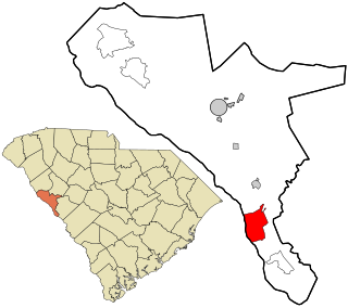
Modoc is a census-designated place (CDP) in McCormick County, South Carolina, United States. The population was 256 at the 2000 census, and 218 at the 2010 census, a decline of 14.8%.

<span class="mw-page-title-main">Mill Creek, West Virginia</span> Town in West Virginia, United States

Mill Creek is a town in Randolph County, West Virginia, United States, along the Tygart Valley River. The population was 563 at the 2020 census.

<span class="mw-page-title-main">Randolph, Maine</span> Town in the state of Maine, United States

Randolph is a town and a census-designated place (CDP) in Kennebec County, Maine, United States. The population was 1,743 at the 2020 census. The town was named for Randolph, Massachusetts. Randolph is included in the Augusta, Maine micropolitan New England City and Town Area.

<span class="mw-page-title-main">Randolph, Wisconsin</span> Village in Wisconsin, United States

Randolph is a village in Columbia and Dodge Counties in the U.S. state of Wisconsin. The population was 1,811 at the 2010 census. Of this, 1,339 were in Dodge County, and 472 were in Columbia County. The village is located at the southeast corner of the Town of Randolph in Columbia County, although only a tiny portion of the village lies within the town. Most of the village lies within the Town of Westford in Dodge County. Small portions also lie within the Town of Fox Lake to the north and the Town of Courtland in Columbia County.

References

  1. "2020 U.S. Gazetteer Files". United States Census Bureau. Retrieved March 16, 2022.
  2. 1 2 3 U.S. Geological Survey Geographic Names Information System: Modoc, Indiana
  3. 1 2 "U.S. Census website". United States Census Bureau . Retrieved January 31, 2008.
  4. Gannett, Henry (1905). The Origin of Certain Place Names in the United States. U.S. Government Printing Office. p.  211.
  5. "Randolph County". Jim Forte Postal History. Retrieved March 10, 2017.
  6. "Census of Population and Housing". Census.gov. Retrieved June 4, 2015.
  7. "U.S. Census website". United States Census Bureau . Retrieved December 11, 2012.
  8. "G001 - Geographic Identifiers - 2010 Census Summary File 1". United States Census Bureau. Archived from the original on February 13, 2020. Retrieved July 17, 2015.