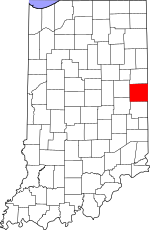
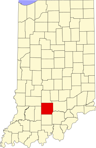
The Indiana General Assembly authorized the formation of Randolph County from Wayne County in January 1818, to take effect in August 1818. According to "The History of Randolph County in 1882" by Ebenezer Tucker, The County was named for Randolph County, Indiana Territory, which later became Randolph County, Illinois, which was named in honor of Edmund Randolph, Governor of Virginia. The county may also have been named for Randolph County, North Carolina, where the area's first settlers came from.[3] That county was named for Peyton Randolph, the first President of the Continental Congress under the Articles of Confederation.[4]
Between 1820 and 1824, the county's territory extended to the Michigan boundary; consequently, the plat for the town of Fort Wayne (now a city) is recorded in Randolph County's Recorder's Office. Randolph County's population grew rapidly in the early years of the nineteenth century. It became known as a progressive community, with many residents coming from the mid-Atlantic and northern tier free states. Numerous members of the Society of Friends (Quakers) lived here, and they supported public education and abolitionism.
The county was the site of three settlements developed by free African Americans, and by 1845 there were about 500 people of color here. The most famous, the Greenville Settlement, in Greensfork Township, was in the southeast part of the county and straddled the state line, also partially in Darke County, Ohio. It was the site of the Union Literary Institute, founded in 1846 by Quakers and free people of color. It was primarily for black students of the area, but also accepted whites as one of the first racially integrated schools in the United States. Other predominately black settlements were Cabin Creek, about 10 miles southwest of Winchester, Indiana; and Snow Hill, between Winchester and Lynn, Indiana.
Given its settlement history, with many migrants from the northern tier, Randolph County was politically dominated by the Republican Party into the early twentieth century. Between 1858 and 1931, the county produced two Governors, one Congressman, one U. S. Senator, three Indiana Secretaries of State, and one State Superintendent of Public Instruction. The county's population growth slowed after 1880.
Randolph County answered the problem of rural decline in the early twentieth century by embracing much of the "Country Life Movement." The county consolidated its rural schools. This was done under the leadership of Lee L. Driver, a county native who became the nation's leading expert on rural school consolidation. Randolph County became the exemplar of the movement, and was the subject of many publications and visits from officials from as far away as Canada and China.
In the early 21st century, residents in Winchester, Union City, and Farmland have sought to revitalize Randolph County through a renewed focus on historic preservation, heritage tourism, and the arts. The county is included in the Ohio River National Freedom Corridor, as many refugees from slavery sought escape via crossing the Ohio River and using aid of residents at stops along the Underground Railroad, sometimes traveling further north and into Canada. In 2016 a state historical marker was installed at the site of the Union Literary Institute, to recognize its contributions to black and interracial education, and the cause of freedom.
Geography
According to the 2010 census, the county has a total area of 453.31 square miles (1,174.1km2), of which 452.38 square miles (1,171.7km2) (or 99.79%) is land and 0.94 square miles (2.4km2) (or 0.21%) is water.[5]
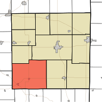
Nettle Creek (Losantville) and West River (Modoc) Townships were combined to form Union Township.
Attractions
McVey Memorial Forest (Located North of Farmland approximately 6 miles on State Road 1)
Farmers market during the summer on the Courthouse Square in Winchester.
Local festivals and events
Mom, Baseball and Apple Pie Festival. (Held in Winchester during August annually.)
Labor Day marathon softball tournament (Winchester City Park and draws teams from all over the United States to play softball and celebrate the last holiday of summer. Winchester's population nearly doubles for this weekend.)
Mardi Gras. (Held annually in October in Winchester.)
State Line Heritage Days. (Held annually in the fall in Union City.)
A Community Christmas, drive-through lightshow at Harter Park in Union City. (Held annually between Thanksgiving and New Year's.)
Airports
Randolph County Airport (newly expanded in 2010 and 2011)
In recent years, average temperatures in Winchester have ranged from a low of 16°F (−9°C) in January to a high of 83°F (28°C) in July, although a record low of −26°F (−32°C) was recorded in January 1994 and a record high of 102°F (39°C) was recorded in September 1953. Average monthly precipitation ranged from 1.63 inches (41mm) in February to 4.34 inches (110mm) in June.[6]
County Council: The county council is the legislative branch of the county government and controls all the spending and revenue collection in the county. Representatives are elected from county districts. The council members serve four-year terms. They are responsible for setting salaries, the annual budget, and special spending. The council also has limited authority to impose local taxes, in the form of an income and property tax that is subject to state level approval, excise taxes, and service taxes.[7][8]
Board of Commissioners: The executive body of the county is made of a board of commissioners. The commissioners are elected county-wide, in staggered terms, and each serves a four-year term. One of the commissioners, typically the most senior, serves as president. The commissioners are charged with executing the acts legislated by the council, collecting revenue, and managing the day-to-day functions of the county government.[7][8]
Court: The county maintains a small claims court that can handle some civil cases. The judge on the court is elected to a term of four years and must be a member of the Indiana Bar Association. The judge is assisted by a constable who is also elected to a four-year term. In some cases, court decisions can be appealed to the state level circuit court.[8]
County Officials: The county has several other elected offices, including sheriff, coroner, auditor, treasurer, recorder, surveyor, and circuit court clerk Each of these elected officers serves a term of four years and oversees a different part of county government. Members elected to county government positions are required to declare party affiliations and to be residents of the county.[8]
Randolph County is one of the most consistently Republican counties in the entire United States. Since 1888, the Republican candidate has only failed to carry the county in a presidential election twice. This occurred in 1912 thanks to the strong third party candidacy of Theodore Roosevelt, as well as 1964 where Barry Goldwater was seen as too conservative statewide & nationally in his landslide loss to Lyndon B. Johnson.
United States presidential election results for Randolph County, Indiana[9]
Public schools in Randolph County are administered by the Union School Corporation, Randolph Southern School Corporation, Randolph Eastern School Corporation, Randolph Central School Corporation, and Monroe Central School Corporation.
Rick Derringer of the group, The McCoys, who had the hit song, "Hang On Sloopy". He also did "Rock N Roll Hoochie Koo" and toured with the Ringo Starr, All-Star Band.
Randy Hobbs, also of the McCoys, one of the great bass guitarists in music history. He also played with Jimi Hendrix, and the Johnny and Edgar Winters Bands.
As of the 2010 United States Census, there were 26,171people, 10,451households, and 7,300families residing in the county.[16] The population density was 57.9 inhabitants per square mile (22.4/km2). There were 11,743 housing units at an average density of 26.0 per square mile (10.0/km2).[5] The racial makeup of the county was 96.1% white, 0.4% black or African American, 0.3% American Indian, 0.2% Asian, 1.8% from other races, and 1.1% from two or more races. Those of Hispanic or Latino origin made up 3.0% of the population.[16] In terms of ancestry, 23.7% were German, 13.9% were Irish, 11.5% were American, and 11.4% were English.[17]
Of the 10,451households, 31.9% had children under the age of 18 living with them, 53.9% were married couples living together, 11.1% had a female householder with no husband present, 30.2% were non-families, and 25.7% of all households were made up of individuals. The average household size was 2.47 and the average family size was 2.93. The median age was 40.8 years.[16]
The median income for a household in the county was $47,697 and the median income for a family was $45,543. Males had a median income of $37,528 versus $28,851 for females. The per capita income for the county was $19,552. About 10.3% of families and 13.2% of the population were below the poverty line, including 20.3% of those under age 18 and 8.7% of those age 65 or over.[18]
Clay County is a county located in the U.S. state of Indiana. As of 2020, the population was 26,466. The county seat is Brazil.
Monroe County is a county located on the eastern border of the U.S. state of Ohio, across the Ohio River from West Virginia. As of the 2020 census, the population was 13,385, making it the second-least populous county in Ohio. Its county seat is Woodsfield. The county was created in 1813 and later organized in 1815.
White County is a county in the U.S. state of Indiana. As of the 2020 United States Census, the population was 24,688. The county seat is Monticello.
Wayne County is a county located in east central Indiana, United States, on the border with Ohio. As of the 2020 United States Census, the population was 66,553. The county seat is Richmond. Wayne County comprises the Richmond, IN Micropolitan Statistical Area. Richmond hosts Earlham College, a small private liberal arts college.
Washington County is a county in the U.S. state of Indiana. As of the 2020 United States Census, the population was 28,182. The county seat is Salem.
Tippecanoe County is located in the west-central portion of the U.S. state of Indiana about 22 miles east of the Illinois state line and less than 50 miles from the Chicago and the Indianapolis metro areas. As of the 2020 census, the population was 186,251. The county seat and largest city is Lafayette. It was created in 1826 from Wabash County portion of New Purchase and unorganized territory.
St. Joseph County, commonly called St. Joe County by residents, is a county located in the U.S. state of Indiana. As of the 2020 census, the population was 272,912, making it the fifth-most populous county in Indiana. Formed in 1830, it was named for the St. Joseph River which flows through it to Lake Michigan. The county seat is South Bend. St. Joseph County is part of the South Bend–Mishawaka, IN–MI "Michiana", Metropolitan Statistical Area.
Pulaski County is a county located in the U.S. state of Indiana. According to the 2020 U.S. census, the population was 12,514. The county seat is Winamac.
Newton County is a county located near the northwestern corner of the U.S. state of Indiana. As of 2020, the population was 13,830. This county is part of Northwest Indiana as well as the Chicago metropolitan area. The county seat is Kentland. The county is divided into 10 townships which provide local services.
Lawrence County is a county located in the U.S. state of Indiana. As of 2020, the population was 45,011. The county seat is Bedford. Lawrence County comprises the Bedford, IN Micropolitan Statistical Area.
Jasper County is a county located in the U.S. state of Indiana. As of 2020, the population was 32,918. The county seat is Rensselaer.
Greene County is a county in the U.S. state of Indiana. As of 2020, the population was 30,803. The county seat is Bloomfield. The county was determined by the US Census Bureau to include the mean center of U.S. population in 1930.
Dubois County is a county located in the U.S. state of Indiana. As of 2020, the population was 43,637. The county seat is Jasper. Dubois County is now the sole county of the Jasper Micropolitan Statistical Area.
Clark County is a county in the U.S. state of Indiana, located directly across the Ohio River from Louisville, Kentucky. At the 2020 census, the population was 121,093. The county seat is Jeffersonville. Clark County is part of the Louisville/Jefferson County, KY–IN Metropolitan Statistical Area.
Cass County is a county located in the U.S. state of Indiana. As of the 2020 United States Census, its population was 37,870. The county seat is Logansport. Cass County comprises the Logansport, IN Micropolitan Statistical Area.
Carroll County is a county located in the U.S. state of Indiana. As of the 2020 United States Census, the population was 20,306. The county seat is Delphi.
Randolph County is a county located in the U.S. state of Illinois. According to the 2020 census, it had a population of 30,163. Its county seat is Chester.
Modoc is a town in Union Township, Randolph County, in the U.S. state of Indiana. The population was 196 at the 2010 census.
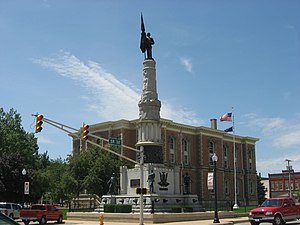
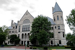
Winchester is a city in White River Township, Randolph County, in the U.S. state of Indiana. The city is the county seat of Randolph County. The population was 4,935 at the 2010 census. It is the home of Winchester Speedway.
Unionville is a rural town in Union County, North Carolina, United States. The population was 6,643 at the 2020 census.
This page is based on this Wikipedia article Text is available under the CC BY-SA 4.0 license; additional terms may apply. Images, videos and audio are available under their respective licenses.