Crawford County, Indiana

Last updated

Crawford County
Crawford County Courthouse, English.jpg
Crawford County Courthouse in English
Map of Indiana highlighting Crawford County.svg
Location within the U.S. state of Indiana
Indiana in United States.svg
Indiana's location within the U.S.
Coordinates: 38°17′N86°28′W / 38.29°N 86.46°W / 38.29; -86.46
CountryFlag of the United States.svg United States
StateFlag of Indiana.svg  Indiana
FoundedJanuary 5, 1818
Named for William H. Crawford
Seat English
Largest town Marengo
Area
  Total308.72 sq mi (799.6 km2)
  Land305.64 sq mi (791.6 km2)
  Water3.08 sq mi (8.0 km2)  1.00%
Population
 (2020)
  Total10,526
  Estimate 
(2023)
10,438 Decrease2.svg
  Density34/sq mi (13/km2)
Time zone UTC−5 (Eastern)
  Summer (DST) UTC−4 (EDT)
Congressional districts 8th, 9th
Website www.crawfordcounty.in.gov
Indiana county number 13

Crawford County is a county located in the U.S. state of Indiana. As of 2020, the population was 10,526. [1] The county seat is English. [2]

Contents

Geography

According to the 2010 census, the county has a total area of 308.72 square miles (799.6 km2), of which 305.64 square miles (791.6 km2) (or 99.00%) is land and 3.08 square miles (8.0 km2) (or 1.00%) is water. [3] Much like the rest of South Central Indiana, the terrain of Crawford County is primarily made up of wooded hills, many of them steep.

Cities and towns

Unincorporated areas

Townships

Transit

Major highways

Adjacent counties

National protected area

History

Crawford County was formed on January 5, 1818, from land in the Harrison, Orange, and Perry counties, prompted by a petition of what would become of Crawford County's population. [4] Some say it was named for William H. Crawford, who was U.S. Treasury Secretary in 1818. Others say it was named for Col. William Crawford, [5] who fought in the French and Indian War and Revolutionary War, and who was burned and scalped by Indians in 1782 in what is now Wyandot County, Ohio. The county seat was in Leavenworth for several decades but eventually moved to English. [6]

Bands of "White Caps" terrorized the county in the late 1880s, according to a report by Attorney General Louis T. Michener. Blacks and others they disliked were forced out; victims, both male and female, were severely whipped. [7]

Climate and weather

English, Indiana
Climate chart (explanation)
J
F
M
A
M
J
J
A
S
O
N
D
 
 
3.7
 
 
41
21
 
 
3.5
 
 
48
24
 
 
4.8
 
 
59
33
 
 
4.7
 
 
69
41
 
 
5.1
 
 
77
49
 
 
4.8
 
 
85
59
 
 
4.2
 
 
88
63
 
 
3.9
 
 
87
61
 
 
3.6
 
 
81
53
 
 
3.1
 
 
70
41
 
 
4.4
 
 
57
34
 
 
4
 
 
46
25
Average max. and min. temperatures in °F
Precipitation totals in inches
Source: The Weather Channel [8]
Metric conversion
J
F
M
A
M
J
J
A
S
O
N
D
 
 
93
 
 
5
−6
 
 
89
 
 
9
−4
 
 
122
 
 
15
1
 
 
120
 
 
21
5
 
 
129
 
 
25
9
 
 
122
 
 
29
15
 
 
108
 
 
31
17
 
 
99
 
 
31
16
 
 
90
 
 
27
12
 
 
80
 
 
21
5
 
 
110
 
 
14
1
 
 
101
 
 
8
−4
Average max. and min. temperatures in °C
Precipitation totals in mm

In recent years, average temperatures in English have ranged from a low of 21 °F (−6 °C) in January to a high of 88 °F (31 °C) in July. Although, a record low of −31 °F (−35 °C) was recorded in January 1977 and a record high of 104 °F (40 °C) was recorded in July 1983. Average monthly precipitation ranged from 3.13 inches (80 mm) in October to 5.06 inches (129 mm) in May. [8]

Government

The county government is a constitutional body, and is granted specific powers by the Constitution of Indiana, and by the Indiana Code.

County Council: The county council is the fiscal branch of the county government and controls all the spending and revenue collection in the county. Representatives are elected from county districts. The council members serve four-year terms. They are responsible for setting salaries, the annual budget, and special spending. The council also has limited authority to impose local taxes, in the form of an income and property tax that is subject to state level approval, excise taxes, and service taxes. [9] [10]

Board of Commissioners: The executive body of the county is made of a board of commissioners. The commissioners are elected county-wide, in staggered terms, and each serves a four-year term. One of the commissioners, typically the most senior, serves as president. The commissioners are charged with executing the acts legislated by the council, collecting revenue, and managing the day-to-day functions of the county government. [9] [10]

Court: The county maintains a small claims court that can handle some civil cases. The judge on the court is elected to a term of four years and must be a member of the Indiana Bar Association. The judge is assisted by a constable who is also elected to a four-year term. In some cases, court decisions can be appealed to the state level circuit court. [10]

County Officials: The county has several other elected offices, including sheriff, coroner, auditor, treasurer, recorder, surveyor, and circuit court clerk. Each of these elected officers serves a term of four years and oversees a different part of county government. Members elected to county government positions are required to declare a party affiliation and to be residents of the county. [10]

Crawford County is part of Indiana's 8th congressional district and is represented in Congress by Republican Larry Bucshon. It is also part of Indiana Senate district 47 [11] and Indiana House of Representatives district 73. [12]

United States presidential election results for Crawford County, Indiana [13]
Year Republican Democratic Third party
No.%No.%No.%
2020 3,48370.39%1,35527.38%1102.22%
2016 3,01564.95%1,32328.50%3046.55%
2012 2,42152.75%2,04144.47%1282.79%
2008 2,39350.44%2,28648.19%651.37%
2004 2,60957.04%1,93242.24%330.72%
2000 2,32755.29%1,81743.17%651.54%
1996 1,75936.57%2,32448.32%72715.11%
1992 1,90338.11%2,26045.25%83116.64%
1988 2,53255.09%2,03644.30%280.61%
1984 2,63353.63%2,25645.95%210.43%
1980 2,55452.51%2,13043.79%1803.70%
1976 2,18144.08%2,72154.99%460.93%
1972 2,62358.96%1,80140.48%250.56%
1968 2,13249.81%1,53635.89%61214.30%
1964 1,82841.74%2,51457.40%380.87%
1960 2,91555.47%2,30543.86%350.67%
1956 2,69451.96%2,43346.92%581.12%
1952 2,75051.85%2,45746.32%971.83%
1948 2,42746.97%2,62550.80%1152.23%
1944 2,48850.50%2,33547.39%1042.11%
1940 2,65247.97%2,83651.29%410.74%
1936 2,58946.91%2,91952.89%110.20%
1932 2,17539.35%3,27259.19%811.47%
1928 2,67257.39%1,93341.52%511.10%
1924 1,91743.08%2,38453.57%1493.35%
1920 2,29049.05%2,21347.40%1663.56%
1916 1,20141.05%1,50851.54%2177.42%
1912 66324.79%1,15943.33%85331.89%
1908 1,40344.50%1,53948.81%2116.69%
1904 1,47045.99%1,50947.22%2176.79%
1900 1,52946.11%1,73152.20%561.69%
1896 1,49047.27%1,65552.51%70.22%
1892 1,27642.21%1,52950.58%2187.21%
1888 1,44546.54%1,62852.43%321.03%

Demographics

Historical population
CensusPop.Note
1820 2,583
1830 3,23825.4%
1840 5,28263.1%
1850 6,52423.5%
1860 8,22626.1%
1870 9,85119.8%
1880 12,35625.4%
1890 13,94112.8%
1900 13,476−3.3%
1910 12,057−10.5%
1920 11,201−7.1%
1930 10,160−9.3%
1940 10,1710.1%
1950 9,289−8.7%
1960 8,379−9.8%
1970 8,033−4.1%
1980 9,82022.2%
1990 9,9141.0%
2000 10,7438.4%
2010 10,713−0.3%
2020 10,526−1.7%
2023 (est.)10,438 [14] −0.8%
U.S. Decennial Census [15]
1790-1960 [16] 1900-1990 [17]
1990-2000 [18] 2010-2013 [1]

As of the 2010 United States Census, there were 10,713 people, 4,303 households, and 2,991 families residing in the county. [19] The population density was 35.1 inhabitants per square mile (13.6/km2). There were 5,520 housing units at an average density of 18.1 per square mile (7.0/km2). [3] The racial makeup of the county was 97.4% white, 0.4% American Indian, 0.2% black or African American, 0.2% Asian, 0.1% Pacific islander, 0.6% from other races, and 1.1% from two or more races. Those of Hispanic or Latino origin made up 1.2% of the population. [19] In terms of ancestry, 23.8% were German, 17.4% were Irish, 13.4% were American, and 8.7% were English. [20]

Of the 4,303 households, 30.6% had children under the age of 18 living with them, 54.6% were married couples living together, 9.7% had a female householder with no husband present, 30.5% were non-families, and 25.6% of all households were made up of individuals. The average household size was 2.48 and the average family size was 2.95. The median age was 41.8 years. [19]

The median income for a household in the county was $47,697 and the median income for a family was $46,073. Males had a median income of $36,465 versus $26,005 for females. The per capita income for the county was $18,598. About 17.4% of families and 18.7% of the population were below the poverty line, including 25.0% of those under age 18 and 15.0% of those age 65 or over. [21]

2020 census

Crawford County Racial Composition [22]
RaceNum.Perc.
White (NH)9,98995%
Black or African American (NH)260.2%
Native American (NH)230.2%
Asian (NH)170.16%
Pacific Islander (NH)10.01%
Other/Mixed (NH)3493.3%
Hispanic or Latino 1211.1%

See also

Related Research Articles

<span class="mw-page-title-main">Clinton County, Indiana</span> County in Indiana, United States

Clinton County is a county located in the U.S. state of Indiana. As of 2020, the population was 33,190. The county seat is Frankfort.

<span class="mw-page-title-main">Warrick County, Indiana</span> County in Indiana, United States

Warrick County is a county located in the U.S. state of Indiana. As of 2020, the population was 63,898. The county seat is Boonville. It was organized in 1813 and was named for Captain Jacob Warrick, an Indiana militia company commander killed in the Battle of Tippecanoe in 1811. It is one of the ten fastest-growing counties in Indiana.

<span class="mw-page-title-main">Wabash County, Indiana</span> County in Indiana, United States

Wabash County is a county located in the northern central part of the U.S. state of Indiana. As of 2020, the population was 30,976. The county seat is Wabash.

<span class="mw-page-title-main">Switzerland County, Indiana</span> County in Indiana, United States

Switzerland County is a county in the southeast corner of the U.S. state of Indiana. As of the 2020 United States Census, the population was 9,737. The county seat is Vevay, one of two incorporated towns in the county.

<span class="mw-page-title-main">Spencer County, Indiana</span> County in Indiana, United States

Spencer County is a county located in the U.S. state of Indiana. As of the 2020 census, the population was 19,810. The county seat is Rockport. Despite not being in the Owensboro Metropolitan Area, the entire riverfront of the city of Owensboro, Kentucky borders the southern tip of the county.

<span class="mw-page-title-main">Pulaski County, Indiana</span> County of Indiana, United States

Pulaski County is a county located in the U.S. state of Indiana. According to the 2020 U.S. census, the population was 12,514. The county seat is Winamac.

<span class="mw-page-title-main">Perry County, Indiana</span> County in Indiana, United States

Perry County is a county located in the southwestern part of the U.S. state of Indiana. As of 2020, the population was 19,170. The county seat is Tell City. It is the hilliest county as well as one of the most forested counties in Indiana as it features more than 60,000 acres (240 km2) of Hoosier National Forest. The Ohio River Scenic Byway along Indiana State Road 66 runs along the southern border of the county while Interstate 64 traverses the northern portion of the county. Connecting the two is Indiana State Road 37.

<span class="mw-page-title-main">Miami County, Indiana</span> County in Indiana, United States

Miami County is a county located in the U.S. state of Indiana. As of 2020, the population was 35,962. The county seat is the City of Peru. Miami County is part of the Kokomo-Peru CSA.

<span class="mw-page-title-main">Johnson County, Indiana</span> County in Indiana, United States

Johnson County is a county located in the U.S. state of Indiana. As of 2020, the population was 161,765. The county seat is Franklin.

<span class="mw-page-title-main">Jennings County, Indiana</span> County in Indiana, United States

Jennings County is a county located in the U.S. state of Indiana. As of 2020, the population was 27,613. The county seat is Vernon.

<span class="mw-page-title-main">Jefferson County, Indiana</span> County in Indiana, United States

Jefferson County is a county located in the U.S. state of Indiana. As of 2020, the population was 33,147. The county seat is Madison.

<span class="mw-page-title-main">Jackson County, Indiana</span> County in Indiana, United States

Jackson County is a county located in the U.S. state of Indiana. As of 2020, the population was 46,428. The county seat is Brownstown.

<span class="mw-page-title-main">Henry County, Indiana</span> County in Indiana, United States

Henry County is a county located in east central Indiana, United States. As of 2020, the population was 48,914. The county seat and largest and only city is New Castle. Henry County is the main setting of the novel Raintree County by Ross Lockridge Jr.

<span class="mw-page-title-main">Hancock County, Indiana</span> County in Indiana, United States

Hancock County is a county in the U.S. state of Indiana. The 2020 United States Census recorded a population of 79,840. The county seat is Greenfield.

<span class="mw-page-title-main">Dubois County, Indiana</span> County in Indiana, United States

Dubois County is a county located in the U.S. state of Indiana. As of 2020, the population was 43,637. The county seat is Jasper. Dubois County is now the sole county of the Jasper Micropolitan Statistical Area.

<span class="mw-page-title-main">Decatur County, Indiana</span> County in Indiana, United States

Decatur County is a county in the U.S. state of Indiana. As of the 2020 United States Census, the population was 26,472. The county seat is Greensburg.

<span class="mw-page-title-main">Dearborn County, Indiana</span> County in Indiana, United States

Dearborn County is one of 92 counties of the U.S. state of Indiana. Located on the Ohio border near the southeast corner of the state, Dearborn County was formed in 1803 from a portion of Hamilton County, Ohio. In 2020, the population was 50,679. The county seat and largest city is Lawrenceburg. Dearborn County is part of the Cincinnati, OH-KY-IN Metropolitan Statistical Area.

<span class="mw-page-title-main">Cass County, Indiana</span> County in Indiana, United States

Cass County is a county located in the U.S. state of Indiana. As of the 2020 United States Census, its population was 37,870. The county seat is Logansport. Cass County comprises the Logansport, IN Micropolitan Statistical Area.

<span class="mw-page-title-main">Bartholomew County, Indiana</span> County in Indiana, United States

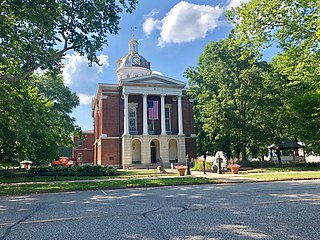
Bartholomew County is a county located in the U.S. state of Indiana. The population was 82,208 at the 2020 census. The county seat is Columbus. The county was determined by the U.S. Census Bureau to be home to the mean center of U.S. population in 1900.

<span class="mw-page-title-main">Scott County, Indiana</span> County in Indiana, United States

Scott County is a county located in the U.S. state of Indiana. As of 2020, the population was 24,384. The county seat is Scottsburg.

References

  1. 1 2 "U.S. Census Bureau QuickFacts: Crawford County, Indiana". www.census.gov. Retrieved December 10, 2021.
  2. "Find a County". National Association of Counties. Archived from the original on May 31, 2011. Retrieved June 7, 2011.
  3. 1 2 "Population, Housing Units, Area, and Density: 2010 - County". United States Census Bureau. Archived from the original on February 12, 2020. Retrieved July 10, 2015.
  4. Pleasant, Hazen (1926). Crawford County History (PDF). WM Mitchell Printing Company.
  5. Gannett, Henry (1905). The Origin of Certain Place Names in the United States. Govt. Print. Off. pp.  95.
  6. De Witt Clinton Goodrich & Charles Richard Tuttle (1875). An Illustrated History of the State of Indiana. Indiana: R. S. Peale & co. pp.  552.
  7. Appleton's Annual Cyclopedia: 1888 (1889), p 441.
  8. 1 2 "Monthly Averages for English, Indiana". The Weather Channel. Retrieved January 27, 2011.
  9. 1 2 Indiana Code. "Title 36, Article 2, Section 3". IN.gov. Retrieved September 16, 2008.
  10. 1 2 3 4 Indiana Code. "Title 2, Article 10, Section 2" (PDF). IN.gov. Retrieved September 16, 2008.
  11. "Indiana Senate Districts". State of Indiana. Retrieved January 23, 2011.
  12. "Indiana House Districts". State of Indiana. Retrieved January 23, 2011.
  13. Leip, David. "Dave Leip's Atlas of U.S. Presidential Elections". uselectionatlas.org. Retrieved May 14, 2018.
  14. "Annual Estimates of the Resident Population for Counties: April 1, 2020 to July 1, 2023". United States Census Bureau. Retrieved April 2, 2024.
  15. "U.S. Decennial Census". United States Census Bureau. Retrieved July 10, 2014.
  16. "Historical Census Browser". University of Virginia Library. Archived from the original on August 11, 2012. Retrieved July 10, 2014.
  17. "Population of Counties by Decennial Census: 1900 to 1990". United States Census Bureau. Retrieved July 10, 2014.
  18. "Census 2000 PHC-T-4. Ranking Tables for Counties: 1990 and 2000" (PDF). United States Census Bureau. Retrieved July 10, 2014.
  19. 1 2 3 "DP-1 Profile of General Population and Housing Characteristics: 2010 Demographic Profile Data". United States Census Bureau. Archived from the original on February 13, 2020. Retrieved July 10, 2015.
  20. "DP02 SELECTED SOCIAL CHARACTERISTICS IN THE UNITED STATES – 2006-2010 American Community Survey 5-Year Estimates". United States Census Bureau. Archived from the original on February 14, 2020. Retrieved July 10, 2015.
  21. "DP03 SELECTED ECONOMIC CHARACTERISTICS – 2006-2010 American Community Survey 5-Year Estimates". United States Census Bureau. Archived from the original on February 14, 2020. Retrieved July 10, 2015.
  22. "P2 HISPANIC OR LATINO, AND NOT HISPANIC OR LATINO BY RACE – 2020: DEC Redistricting Data (PL 94-171) – Crawford County, Indiana".

Sources

38°17′N86°28′W / 38.29°N 86.46°W / 38.29; -86.46