Greene County, Indiana

Last updated

Greene County
Greene County Courthouse in Bloomfield front and western side distant.jpg
Greene County Courthouse in Bloomfield
Map of Indiana highlighting Greene County.svg
Location within the U.S. state of Indiana
Indiana in United States.svg
Indiana's location within the U.S.
Coordinates: 39°02′N86°58′W / 39.04°N 86.97°W / 39.04; -86.97
CountryFlag of the United States.svg United States
StateFlag of Indiana.svg  Indiana
FoundedJanuary 5, 1821
Named for Nathanael Greene
Seat Bloomfield
Largest city Linton
Area
  Total545.92 sq mi (1,413.9 km2)
  Land542.50 sq mi (1,405.1 km2)
  Water3.42 sq mi (8.9 km2)  0.63%
Population
 (2020)
  Total30,803
  Density56/sq mi (22/km2)
Time zone UTC−5 (Eastern)
  Summer (DST) UTC−4 (EDT)
Congressional district 8th
Website www.co.greene.in.us
Indiana county number 28

Greene County is a county in the U.S. state of Indiana. As of 2020, the population was 30,803. [1] The county seat is Bloomfield. [2] The county was determined by the US Census Bureau to include the mean center of U.S. population in 1930. [3]

Contents

History

Greene County was formed in 1821, from unincorporated territory and from a portion of the previous Sullivan County. It was named for General Nathanael Greene, who commanded the southern theater in the American Revolutionary War, which eventually forced the British army under Charles Cornwallis to retreat to Yorktown. There it was forced to surrender, ensuring American independence. [4]

Climate and weather

Bloomfield, Indiana
Climate chart (explanation)
J
F
M
A
M
J
J
A
S
O
N
D
 
 
2.2
 
 
36
18
 
 
2.5
 
 
41
20
 
 
4.2
 
 
52
32
 
 
3.9
 
 
64
42
 
 
5
 
 
75
51
 
 
4.2
 
 
83
61
 
 
4.7
 
 
87
64
 
 
3.6
 
 
85
63
 
 
3.2
 
 
79
55
 
 
3.1
 
 
68
43
 
 
3.7
 
 
54
34
 
 
3.5
 
 
41
23
Average max. and min. temperatures in °F
Precipitation totals in inches
Source: The Weather Channel [5]
Metric conversion
J
F
M
A
M
J
J
A
S
O
N
D
 
 
56
 
 
2
−8
 
 
64
 
 
5
−7
 
 
107
 
 
11
0
 
 
99
 
 
18
6
 
 
127
 
 
24
11
 
 
107
 
 
28
16
 
 
119
 
 
31
18
 
 
91
 
 
29
17
 
 
81
 
 
26
13
 
 
79
 
 
20
6
 
 
94
 
 
12
1
 
 
89
 
 
5
−5
Average max. and min. temperatures in °C
Precipitation totals in mm

In recent years, average temperatures in Bloomfield have ranged from a low of 18 °F (−8 °C) in January to a high of 87 °F (31 °C) in July, although a record low of −21 °F (−29 °C) was recorded in January 1963 and a record high of 106 °F (41 °C) was recorded in June 1953. Average monthly precipitation ranged from 2.20 inches (56 mm) in January to 5.00 inches (127 mm) in May. [5]

Government

The county government is a constitutional body, and is granted specific powers by the Constitution of Indiana, and by the Indiana Code.

County Council: The county council is the legislative branch of the county government and controls all the spending and revenue collection in the county. Representatives are elected from county districts. The council members serve four-year terms. They are responsible for setting salaries, the annual budget, and special spending. The council also has limited authority to impose local taxes, in the form of an income and property tax that is subject to state level approval, excise taxes, and service taxes. [6] [7]

Board of Commissioners: The executive body of the county is made of a board of commissioners. The commissioners are elected county-wide, in four-year staggered terms. This board is charged with executing the acts legislated by the council, collecting revenue, and managing the day-to-day functions of the county government. [6] [7]

Court: The county maintains a small claims court that can handle some civil cases. The judge on the court is elected to a term of four years and must be a member of the Indiana Bar Association. The judge is assisted by a constable who is also elected to a four-year term. In some cases, court decisions can be appealed to the state level circuit court. [7]

County Officials: The county has several other elected offices, including sheriff, coroner, auditor, treasurer, recorder, surveyor and circuit court clerk. Each serves a term of four years and oversees a different part of county government. Members elected to county government positions are required to declare party affiliations and to be residents of the county. [7]

Greene County is part of Indiana's 8th congressional district; Indiana Senate districts 39 and 48; [8] and Indiana House of Representatives districts 45, 60 and 62. [9]

Greene County tends to vote Republican. Since 1888, county voters have chosen the Republican Party nominee in 73% (24 of 34) of the elections through 2020.

United States presidential election results for Greene County, Indiana [10]
Year Republican Democratic Third party
No.%No.%No.%
2020 11,10374.98%3,38922.89%3152.13%
2016 10,27774.14%2,92921.13%6554.73%
2012 8,45764.36%4,35033.10%3342.54%
2008 7,69156.34%5,70941.82%2501.83%
2004 8,60964.48%4,60634.50%1371.03%
2000 7,45259.05%4,89838.81%2692.13%
1996 5,74644.67%5,27741.03%1,83914.30%
1992 5,41039.76%5,43139.91%2,76720.33%
1988 7,68955.94%5,97943.50%780.57%
1984 8,43860.71%5,26737.90%1931.39%
1980 7,45252.86%6,02742.75%6194.39%
1976 6,44246.54%7,26352.47%1381.00%
1972 8,45364.80%4,45034.11%1421.09%
1968 6,52548.37%5,49340.72%1,47310.92%
1964 5,91940.62%8,57458.85%770.53%
1960 8,81057.81%6,32541.51%1040.68%
1956 8,72254.62%7,18645.00%610.38%
1952 8,62053.25%7,41745.82%1520.94%
1948 7,45348.20%7,70949.85%3011.95%
1944 8,21354.44%6,74444.70%1290.86%
1940 9,07150.71%8,71848.73%1000.56%
1936 7,46043.01%9,73056.10%1540.89%
1932 6,39740.15%8,84555.51%6914.34%
1928 8,26257.81%5,76140.31%2681.88%
1924 6,67045.93%5,96641.09%1,88512.98%
1920 7,48648.65%6,33541.17%1,56710.18%
1916 3,87843.33%3,99044.59%1,08112.08%
1912 2,15625.11%3,37339.28%3,05735.60%
1908 4,14544.17%4,17244.45%1,06811.38%
1904 4,69853.13%3,55940.25%5866.63%
1900 3,50248.46%3,49148.31%2333.22%
1896 3,43450.28%3,34448.96%520.76%
1892 2,80948.06%2,48842.57%5489.38%
1888 2,93451.96%2,65947.09%540.96%

Education

Greene County has five separate school districts.

Geography

According to the 2010 census, the county has a total area of 545.92 square miles (1,413.9 km2), of which 542.50 square miles (1,405.1 km2) (or 99.37%) is land and 3.42 square miles (8.9 km2) (or 0.63%) is water. [11]

Adjacent counties

Cities

Towns

Census-designated places

Other unincorporated places

Townships

Major highways

Economy

The Greene County Economic Development Corporation (GCEDC) currently serves to develop new businesses and support current businesses in Greene County, Indiana. [13] This asset was established to assist in bringing projects to the county. Coupled with The Indiana Economic Development Corporation, Greene County has developed an incentive portfolio to assist potential new employers.

The county has been designated a Labor Surplus Area and an SBA HUB Zone (Historically Underused Business Zone), which provides advantages to county businesses in government contract bidding and eligibility for federal and state assistance. Employee location and screening services are offered by WorkOne Linton, the local branch of the Indiana State Workforce Development office. Worker training programs are available onsite and at the Greene County Community Learning Center, which serves as a local access site for area colleges and universities.

Demographics

Historical population
CensusPop.Note
1830 4,242
1840 8,32196.2%
1850 12,31348.0%
1860 16,04130.3%
1870 19,51421.7%
1880 22,99617.8%
1890 24,3796.0%
1900 28,53017.0%
1910 36,87329.2%
1920 36,770−0.3%
1930 31,481−14.4%
1940 31,330−0.5%
1950 27,886−11.0%
1960 26,327−5.6%
1970 26,8942.2%
1980 30,41613.1%
1990 30,4100.0%
2000 33,1579.0%
2010 33,1650.0%
2020 30,803−7.1%
2023 (est.)31,196 [14] 1.3%
US Decennial Census [15]
1790–1960 [16] 1900–1990 [17]
1990–2000 [18] 2010 [19]

As of the 2010 United States Census, there were 33,165 people, 13,487 households, and 9,276 families in the county. [20] The population density was 61.1 inhabitants per square mile (23.6/km2). There were 15,211 housing units at an average density of 28.0 per square mile (10.8/km2). [11] The racial makeup of the county was 98.1% white, 0.3% Asian, 0.3% American Indian, 0.1% black or African American, 0.3% from other races, and 0.9% from two or more races. Those of Hispanic or Latino origin made up 1.0% of the population. [20] In terms of ancestry, 25.5% were German, 16.8% were Irish, 12.9% were American, and 11.2% were English. [21]

Of the 13,487 households, 31.8% had children under the age of 18 living with them, 54.3% were married couples living together, 9.4% had a female householder with no husband present, 31.2% were non-families, and 27.0% of all households were made up of individuals. The average household size was 2.44 and the average family size was 2.92. The median age was 41.1 years. [20]

The median income for a household in the county was $47,697 and the median income for a family was $50,740. Males had a median income of $41,524 versus $31,890 for females. The per capita income for the county was $20,676. About 10.0% of families and 14.4% of the population were below the poverty line, including 19.7% of those under age 18 and 8.9% of those age 65 or over. [22]

2020 census

As of the 2020 United States Census the population was 30,803. [23]

Greene County Racial Composition [23]
RaceNum.Perc.
White (NH)29,03594.2%
Black or African American (NH)530.17%
Native American (NH)680.2%
Asian (NH)1040.34%
Pacific Islander (NH)40.01%
Other/Mixed (NH)9883.2%
Hispanic or Latino 5511.8%

See also

Related Research Articles

<span class="mw-page-title-main">Clinton County, Indiana</span> County in Indiana, United States

Clinton County is a county located in the U.S. state of Indiana. As of 2020, the population was 33,190. The county seat is Frankfort.

<span class="mw-page-title-main">Clay County, Indiana</span> County in Indiana, United States

Clay County is a county located in the U.S. state of Indiana. As of 2020, the population was 26,466. The county seat is Brazil.

<span class="mw-page-title-main">Greene County, Ohio</span> County in Ohio, United States

Greene County is located in the southwestern portion of Ohio. As of the 2020 census, the population was 167,966. Its county seat is Xenia and its largest city is Beavercreek. The county was established on March 24, 1803 and named for General Nathanael Greene, an officer in the Revolutionary War. Greene County is part of the Dayton, OH Metropolitan Statistical Area.

<span class="mw-page-title-main">Warrick County, Indiana</span> County in Indiana, United States

Warrick County is a county located in the U.S. state of Indiana. As of 2020, the population was 63,898. The county seat is Boonville. It was organized in 1813 and was named for Captain Jacob Warrick, an Indiana militia company commander killed in the Battle of Tippecanoe in 1811. It is one of the ten fastest-growing counties in Indiana.

<span class="mw-page-title-main">St. Joseph County, Indiana</span> County in Indiana, United States

St. Joseph County, commonly called St. Joe County by residents, is a county located in the U.S. state of Indiana. As of the 2020 census, the population was 272,912, making it the fifth-most populous county in Indiana. Formed in 1830, it was named for the St. Joseph River which flows through it to Lake Michigan. The county seat is South Bend. St. Joseph County is part of the South Bend–Mishawaka, IN–MI "Michiana", Metropolitan Statistical Area.

<span class="mw-page-title-main">Spencer County, Indiana</span> County in Indiana, United States

Spencer County is a county located in the U.S. state of Indiana. As of the 2020 census, the population was 19,810. The county seat is Rockport. Despite not being in the Owensboro Metropolitan Area, the entire riverfront of the city of Owensboro, Kentucky borders the southern tip of the county.

<span class="mw-page-title-main">Posey County, Indiana</span> County in Indiana, United States

Posey County is the southernmost, southwesternmost, and westernmost county in the U.S. state of Indiana. Its southern border is formed by the Ohio River, and its western border by the Wabash River, a tributary to the Ohio. As of 2020, the population was 25,222. The county seat is Mount Vernon.

<span class="mw-page-title-main">Owen County, Indiana</span> County in Indiana, United States

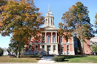
Owen County is a county in the U.S. state of Indiana. In 1920 the United States Census Bureau calculated the mean center of U.S. population to fall within this county. As of the 2020 United States Census, it had a population of 21,321. Its county seat is Spencer.

<span class="mw-page-title-main">Martin County, Indiana</span> County in Indiana, United States

Martin County is a county in the U.S. state of Indiana. As of the 2020 United States Census, the population was 9,812. The county seat is Shoals at the center of the county, and the county's only incorporated city is Loogootee, on the county's western border.

<span class="mw-page-title-main">Marshall County, Indiana</span> County in Indiana, United States

Marshall County is a county in the U.S. state of Indiana. The 2020 census recorded the population at 46,095. The county seat is Plymouth.

<span class="mw-page-title-main">Knox County, Indiana</span> County in Indiana, United States

Knox County is a county in the U.S. state of Indiana in the United States. The oldest county in Indiana, it was one of two original counties created in the Northwest Territory in 1790, alongside St. Clair County, Illinois. Knox County was gradually reduced in size as subsequent counties were established. It was established in its present configuration when Daviess County was partitioned off. At the 2020 United States Census, the county population was 36,282. The county seat is Vincennes.

<span class="mw-page-title-main">Jay County, Indiana</span> County in Indiana, United States

Jay County is a county in the U.S. state of Indiana. As of 2020, the population was 20,478. The county seat is Portland.

<span class="mw-page-title-main">Howard County, Indiana</span> County in Indiana, United States

Howard County is one of 92 counties in the U.S. state of Indiana. As of the 2020 census, the population was 83,658. The county seat is Kokomo. Originally named Richardville County, it was renamed in 1844 to commemorate General Tilghman Ashurst Howard.

<span class="mw-page-title-main">Hendricks County, Indiana</span> County in Indiana, United States

Hendricks County is a county in the U.S. state of Indiana. As of the 2020 United States Census, the population was 174,788. The county seat is the town of Danville.

<span class="mw-page-title-main">Grant County, Indiana</span> County in Indiana, United States

Grant County is a county in central Indiana in the United States Midwest. At the time of the 2020 census, the population was 66,674. The county seat is Marion. Important paleontological discoveries, dating from the Pliocene epoch, have been made at the Pipe Creek Sinkhole in Grant County.

<span class="mw-page-title-main">Daviess County, Indiana</span> County in Indiana, United States

Daviess County is a county in the U.S. state of Indiana. As of the 2020 United States Census, the population was 33,381. The county seat is Washington. About 15% of the county's population is Amish of Swiss origin, as of 2017.

<span class="mw-page-title-main">Cass County, Indiana</span> County in Indiana, United States

Cass County is a county located in the U.S. state of Indiana. As of the 2020 United States Census, its population was 37,870. The county seat is Logansport. Cass County comprises the Logansport, IN Micropolitan Statistical Area.

<span class="mw-page-title-main">Aurora, Indiana</span> City in Indiana, United States

Aurora is a city in Center Township, Dearborn County, Indiana, United States. The population was 3,750 at the 2010 census.

<span class="mw-page-title-main">Bloomfield, Indiana</span> Town in Indiana, United States

Bloomfield is a town within Richland Township and the county seat of Greene County, Indiana, United States. The population was 2,405 at the 2010 census.

<span class="mw-page-title-main">Linton, Indiana</span> City in Indiana, United States

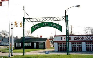
Linton is a city in Stockton Township, Greene County, Indiana, United States. The population was 5,133 at the 2020 census. A coal mining city, it is located southeast of Terre Haute.

References

  1. "Greene County, Indiana". United States Census Bureau . Retrieved May 30, 2023.
  2. "Find a County". National Association of Counties. Retrieved June 7, 2011.
  3. "Mean Center of Population for the United States: 1790 to 2000" (PDF). US Census Bureau. Retrieved September 17, 2011.
  4. Baker, Ronald L.; Carmony, Marvin (1975). Indiana Place Names. Bloomington IN: Indiana University Press. p. 63.
  5. 1 2 "Monthly Averages for Bloomfield IN". The Weather Channel. Retrieved January 27, 2011.
  6. 1 2 Indiana Code. "Title 36, Article 2, Section 3". IN.gov. Retrieved September 16, 2008.
  7. 1 2 3 4 Indiana Code. "Title 2, Article 10, Section 2" (PDF). IN.gov. Retrieved September 16, 2008.
  8. "Indiana Senate Districts". State of Indiana. Retrieved July 14, 2011.
  9. "Indiana House Districts". State of Indiana. Retrieved July 14, 2011.
  10. Leip, David. "Dave Leip's Atlas of U.S. Presidential Elections" . Retrieved May 16, 2018.
  11. 1 2 "Population, Housing Units, Area, and Density: 2010 – County". US Census Bureau. Archived from the original on February 10, 2020. Retrieved July 10, 2015.
  12. Dresden (Visit Greene County)
  13. Greene County Economic Development Corporation
  14. "Annual Estimates of the Resident Population for Counties: April 1, 2020 to July 1, 2023". United States Census Bureau. Retrieved April 2, 2024.
  15. "US Decennial Census". US Census Bureau. Retrieved July 10, 2014.
  16. "Historical Census Browser". University of Virginia Library. Retrieved July 10, 2014.
  17. "Population of Counties by Decennial Census: 1900 to 1990". US Census Bureau. Retrieved July 10, 2014.
  18. "Census 2000 PHC-T-4. Ranking Tables for Counties: 1990 and 2000" (PDF). US Census Bureau. Retrieved July 10, 2014.
  19. "Greene County QuickFacts". US Census Bureau. Archived from the original on July 6, 2011. Retrieved September 17, 2011.
  20. 1 2 3 "Profile of General Population and Housing Characteristics: 2010 Demographic Profile Data". US Census Bureau. Archived from the original on February 13, 2020. Retrieved July 10, 2015.
  21. "Selected Social Characteristics in the United States – 2006–2010 American Community Survey 5-Year Estimates". US Census Bureau. Archived from the original on February 14, 2020. Retrieved July 10, 2015.
  22. "Selected Economic Characteristics – 2006–2010 American Community Survey 5-Year Estimates". US Census Bureau. Archived from the original on February 14, 2020. Retrieved July 10, 2015.
  23. 1 2 "P2 HISPANIC OR LATINO, AND NOT HISPANIC OR LATINO BY RACE – 2020: DEC Redistricting Data (PL 94-171) – Greene County, Indiana".

39°02′N86°58′W / 39.04°N 86.97°W / 39.04; -86.97