Carroll County, Indiana

Last updated

Carroll County
Carrol County 1916.jpg
Carroll County courthouse in Delphi
Map of Indiana highlighting Carroll County.svg
Location within the U.S. state of Indiana
Indiana in United States.svg
Indiana's location within the U.S.
Coordinates: 40°35′N86°34′W / 40.58°N 86.56°W / 40.58; -86.56
CountryFlag of the United States.svg United States
StateFlag of Indiana.svg  Indiana
FoundedJanuary 17, 1828 (authorized)
April 28, 1828 (organized)
Named for Charles Carroll of Carrollton
Seat Delphi
Largest cityDelphi
Area
  Total375.02 sq mi (971.3 km2)
  Land372.22 sq mi (964.0 km2)
  Water2.80 sq mi (7.3 km2)  0.75%
Population
 (2020)
  Total20,306
  Density54/sq mi (21/km2)
Time zone UTC−5 (Eastern)
  Summer (DST) UTC−4 (EDT)
Congressional district 4th
Website www.carrollcountyindiana.com
Indiana county number 8

Carroll County is a county located in the U.S. state of Indiana. As of the 2020 United States Census, the population was 20,306. [1] The county seat is Delphi. [2]

Contents

Carroll County is part of the Lafayette, Indiana, Metropolitan Statistical Area.

History

In 1787, the fledgling United States defined the Northwest Territory, which included the area of present-day Indiana. In 1800, Congress separated Ohio from the Northwest Territory, designating the rest of the land as the Indiana Territory. [3] President Thomas Jefferson chose William Henry Harrison as the territory's first governor, and Vincennes was established as the territorial capital. [4] After the Michigan Territory was separated and the Illinois Territory was formed, Indiana was reduced to its current size and geography. [3] By December 1816, the Indiana Territory was admitted to the Union as a state.

Starting in 1794, Native American titles to Indiana lands were extinguished by usurpation, purchase, or war and treaty. The United States acquired land from the Native Americans in the treaty of St. Mary's in 1818, which included most of the future county, and in 1826 the Treaty of Mississinewas made more area available for settlement. These two treaties resolved the occupation issue for the future Carroll County.

White people had been living in the future Carroll County area since 1824 [5] and their numbers increased rapidly in the next few years. Accordingly, Carroll County was authorized by the state legislature on January 17, 1828; it was named for Charles Carroll, the last surviving signer of the Declaration of Independence, who died in 1832. [5] [6] The first commissioners began organizing the county government on April 28 of that year and determined to site the county seat at land donated by William Wilson. The name 'Carrollton' was first suggested for the new community, but at the suggestion of General Samuel Milroy, 'Delphi' was selected instead. [5]

The Wabash and Erie Canal, built through the county in 1840 and operating until the early 1870s, is among the county's most significant historical legacies.[ citation needed ]

Courthouse

The first county courthouse was built in 1831. It was replaced by a brick structure in 1856. The 730-pound bell from the first courthouse was made in Cincinnati in 1836 and given by Sheriff Samuel Davis Gresham and was used in the second courthouse until 1916. While the bell was in transit to Lafayette by boat, the boat sank. The bell was recovered from the Ohio River, and was sold, but was returned to Carroll County in 1967. [7]

The current Carroll County courthouse was designed by Jaxson Cowell of Indianapolis, who also designed the Spencer County courthouse. It was constructed by A. E. Kemmer at a cost of about $250,000 from 1916 to 1917. The exterior is understated, but the interior is surprisingly elaborate, including a stained glass dome over a mosaic tile floor.

Geography

The Wabash River flows southwestward from Cass County through the upper part of Carroll County, exiting into Tippecanoe County. The Tippecanoe River flows southward through the county's upper west edge, also exiting into Tippecanoe County, where it merges with the Wabash shortly after leaving Carroll County's border. Wildcat Creek drains the south part of Carroll County, flowing westward into Tippecanoe to merge with the Wabash there.

The terrain of Carroll County was heavily wooded at the start, but now the flat areas are cleared and devoted to agriculture or urban development, with only the drainage areas still wooded. [8] The highest point on the terrain (830 feet/250 meters ASL) is the county's SE corner. [9]

According to the 2010 census, the county has a total area of 375.02 square miles (971.3 km2), of which 372.22 square miles (964.0 km2) (or 99.25%) is land and 2.80 square miles (7.3 km2) (or 0.75%) is water. [10]

Adjacent counties

City

Towns

Unincorporated communities

Townships

Major highways

Railroads

Climate and weather

Delphi, Indiana
Climate chart (explanation)
J
F
M
A
M
J
J
A
S
O
N
D
 
 
2
 
 
33
17
 
 
1.9
 
 
39
21
 
 
2.9
 
 
51
31
 
 
3.5
 
 
64
40
 
 
3.9
 
 
74
50
 
 
4.1
 
 
83
60
 
 
4.2
 
 
86
63
 
 
4
 
 
84
61
 
 
2.9
 
 
78
53
 
 
2.7
 
 
66
42
 
 
3.1
 
 
51
33
 
 
2.7
 
 
38
23
Average max. and min. temperatures in °F
Precipitation totals in inches
Source: The Weather Channel [11]
Metric conversion
J
F
M
A
M
J
J
A
S
O
N
D
 
 
51
 
 
1
−8
 
 
49
 
 
4
−6
 
 
75
 
 
11
−1
 
 
88
 
 
18
4
 
 
99
 
 
23
10
 
 
103
 
 
28
16
 
 
106
 
 
30
17
 
 
101
 
 
29
16
 
 
75
 
 
26
12
 
 
69
 
 
19
6
 
 
79
 
 
11
1
 
 
68
 
 
3
−5
Average max. and min. temperatures in °C
Precipitation totals in mm

In recent years, average temperatures in Delphi have ranged from a low of 17 °F (−8 °C) in January to a high of 86 °F (30 °C) in July, although a record low of −25 °F (−32 °C) was recorded in January 1963 and a record high of 107 °F (42 °C) was recorded in July 1954. Average monthly precipitation ranged from 1.94 inches (49 mm) in February to 4.16 inches (106 mm) in July. [11]

Government

The county government is a constitutional body, and is granted specific powers by the Constitution of Indiana, and by the Indiana Code.

County Council: The legislative branch of the county government; controls spending and revenue collection in the county. Representatives are elected to four-year terms from county districts. They set salaries, the annual budget, and special spending. The council has limited authority to impose local taxes, in the form of an income and property tax that is subject to state level approval, excise taxes, and service taxes. [12] [13]

Board of Commissioners: The executive body of the county; commissioners are elected county-wide to staggered four-year terms. One commissioner serves as president. The commissioners execute acts legislated by the council, collect revenue, and manage the county government. [12] [13]

Court: The county maintains a small claims court that handles civil cases. The judge on the court is elected to a term of four years and must be a member of the Indiana Bar Association. The judge is assisted by a constable who is also elected to a four-year term. In some cases, court decisions can be appealed to the state level circuit court. [13]

County Officials: The county has other elected offices, including sheriff, coroner, auditor, treasurer, recorder, surveyor, and circuit court clerk. These officers are elected to four-year terms. Members elected to county government positions are required to declare a party affiliation and to be residents of the county. [13]

Carroll County is part of Indiana's 4th congressional district and is represented by Jim Baird in the United States Congress. It is also part of Indiana Senate district 7 [14] and Indiana House of Representatives district 24. [15]

United States presidential election results for Carroll County, Indiana [16]
Year Republican Democratic Third party
No.%No.%No.%
2020 7,08674.48%2,22423.38%2042.14%
2016 6,27372.10%1,89221.74%5366.16%
2012 4,99964.01%2,63533.74%1762.25%
2008 4,85855.61%3,73642.77%1421.63%
2004 5,86867.93%2,68931.13%810.94%
2000 5,10261.71%2,96535.86%2012.43%
1996 4,06250.58%2,74734.20%1,22215.22%
1992 3,80044.38%2,56129.91%2,20125.71%
1988 4,98162.54%2,95237.07%310.39%
1984 5,52866.09%2,77433.17%620.74%
1980 5,26260.49%2,96634.10%4715.41%
1976 4,79756.48%3,60642.46%901.06%
1972 5,88572.32%2,21427.21%380.47%
1968 4,79656.19%2,81632.99%92310.81%
1964 3,89644.71%4,78954.96%290.33%
1960 5,41161.88%3,29937.73%340.39%
1956 5,74863.26%3,31236.45%260.29%
1952 5,90264.31%3,20834.95%680.74%
1948 4,59753.99%3,84545.16%720.85%
1944 4,87257.28%3,57842.07%550.65%
1940 5,01254.05%4,21445.44%470.51%
1936 4,42648.28%4,67651.01%650.71%
1932 3,85343.79%4,86655.30%800.91%
1928 4,78059.54%3,18239.64%660.82%
1924 4,54353.52%3,66043.11%2863.37%
1920 5,00653.92%4,18645.09%920.99%
1916 2,46849.09%2,40147.75%1593.16%
1912 1,46730.03%2,27546.57%1,14323.40%
1908 2,54647.46%2,59048.28%2294.27%
1904 2,67149.96%2,42045.27%2554.77%
1900 2,58547.59%2,69049.52%1572.89%
1896 2,54647.43%2,76451.49%581.08%
1892 2,23044.43%2,36147.04%4288.53%
1888 2,60748.96%2,56048.08%1582.97%

Demographics

Historical population
CensusPop.Note
1830 1,611
1840 7,819385.4%
1850 11,01540.9%
1860 13,48922.5%
1870 16,15219.7%
1880 18,34513.6%
1890 20,0219.1%
1900 19,953−0.3%
1910 17,970−9.9%
1920 16,315−9.2%
1930 15,049−7.8%
1940 15,4102.4%
1950 16,0103.9%
1960 16,9345.8%
1970 17,7344.7%
1980 19,72211.2%
1990 18,809−4.6%
2000 20,1657.2%
2010 20,1550.0%
2020 20,3060.7%
2023 (est.)20,525 [17] 1.1%
US Decennial Census [18]
1790-1960 [19] 1900-1990 [20]
1990-2000 [21] 2010 [22]

2010 census

As of the 2010 United States Census, there were 20,155 people, 7,900 households, and 5,678 families in the county. [23] The population density was 54.1 inhabitants per square mile (20.9/km2). There were 9,472 housing units at an average density of 25.4 per square mile (9.8/km2). [10] The racial makeup of the county was 96.8% white, 0.2% American Indian, 0.2% black or African American, 0.1% Asian, 1.7% from other races, and 1.0% from two or more races. Those of Hispanic or Latino origin made up 3.5% of the population. [23] In terms of ancestry, 29.7% were German, 14.7% were American, 12.6% were Irish, and 8.8% were English. [24]

Of the 7,900 households, 32.1% had children under the age of 18 living with them, 59.5% were married couples living together, 7.3% had a female householder with no husband present, 28.1% were non-families, and 24.0% of all households were made up of individuals. The average household size was 2.54 and the average family size was 2.98. The median age was 40.9 years. [23]

The median income for a household in the county was $47,697 and the median income for a family was $60,420. Males had a median income of $46,241 versus $29,541 for females. The per capita income for the county was $23,163. About 6.1% of families and 9.4% of the population were below the poverty line, including 11.0% of those under age 18 and 8.3% of those age 65 or over. [25]

2020 census

As of the 2020 United States Census, there were 20,306 people [26]

Carroll County Racial Composition [26]
RaceNum.Perc.
White (NH)18,72792.2%
Black or African American (NH)1280.6%
Native American (NH)330.16%
Asian (NH)480.24%
Pacific Islander (NH)00%
Other/Mixed (NH)5472.7%
Hispanic or Latino 8234.1%

Education

Public schools in Carroll County are administered by the following school districts: [27]

High schools and middle schools

Elementary schools

See also

Related Research Articles

<span class="mw-page-title-main">Clinton County, Indiana</span> County in Indiana, United States

Clinton County is a county located in the U.S. state of Indiana. As of 2020, the population was 33,190. The county seat is Frankfort.

<span class="mw-page-title-main">Clay County, Indiana</span> County in Indiana, United States

Clay County is a county located in the U.S. state of Indiana. As of 2020, the population was 26,466. The county seat is Brazil.

<span class="mw-page-title-main">Montgomery County, Indiana</span> County in Indiana, United States

Montgomery County is a county in the U.S. state of Indiana. As of the 2020 United States census, it had a population of 37,936. Its county seat is Crawfordsville. The county is divided into eleven townships which provide local services.

<span class="mw-page-title-main">White County, Indiana</span> County in Indiana, United States

White County is a county in the U.S. state of Indiana. As of the 2020 United States Census, the population was 24,688. The county seat is Monticello.

<span class="mw-page-title-main">Vermillion County, Indiana</span> County in Indiana, United States

Vermillion County lies in the western part of the U.S. state of Indiana between the Illinois border and the Wabash River. As of the 2020 census, the population was 15,439. The county seat is Newport. It was officially established in 1824 and was the fiftieth Indiana county created. Vermillion County is included in the Terre Haute, Indiana, Metropolitan Statistical Area. The county contains seven incorporated towns with a total population of about 9,900. as well as several unincorporated communities; it is also divided into five townships which provide local services. An interstate highway, two U.S. routes, and five state roads cross the county, as does a major railroad line.

<span class="mw-page-title-main">Tippecanoe County, Indiana</span> County in Indiana, United States

Tippecanoe County is located in the west-central portion of the U.S. state of Indiana about 22 miles east of the Illinois state line and less than 50 miles from the Chicago and the Indianapolis metro areas. As of the 2020 census, the population was 186,251. The county seat and largest city is Lafayette. It was created in 1826 from Wabash County portion of New Purchase and unorganized territory.

<span class="mw-page-title-main">Sullivan County, Indiana</span> County in Indiana, United States

Sullivan County is a county in the U.S. state of Indiana, and determined by the US Census Bureau to include the mean center of U.S. population in 1940. As of 2020, the population was 20,758. The county seat is Sullivan.

<span class="mw-page-title-main">Pulaski County, Indiana</span> County of Indiana, United States

Pulaski County is a county located in the U.S. state of Indiana. According to the 2020 U.S. census, the population was 12,514. The county seat is Winamac.

<span class="mw-page-title-main">Parke County, Indiana</span> County in Indiana, United States

Parke County lies in the western part of the U.S. state of Indiana along the Wabash River. The county was formed in 1821 out of a portion of Vigo County. According to the 2020 census, the population was 16,156. The county seat is Rockville.

<span class="mw-page-title-main">Kosciusko County, Indiana</span> County in Indiana, United States

Kosciusko County is a county in the U.S. state of Indiana. At the 2020 United States Census, its population was 80,240. The county seat is Warsaw.

<span class="mw-page-title-main">Knox County, Indiana</span> County in Indiana, United States

Knox County is a county in the U.S. state of Indiana in the United States. The oldest county in Indiana, it was one of two original counties created in the Northwest Territory in 1790, alongside St. Clair County, Illinois. Knox County was gradually reduced in size as subsequent counties were established. It was established in its present configuration when Daviess County was partitioned off. At the 2020 United States Census, the county population was 36,282. The county seat is Vincennes.

<span class="mw-page-title-main">Hancock County, Indiana</span> County in Indiana, United States

Hancock County is a county in the U.S. state of Indiana. The 2020 United States Census recorded a population of 79,840. The county seat is Greenfield.

<span class="mw-page-title-main">Fountain County, Indiana</span> County in Indiana, United States

Fountain County lies in the western part of the U.S. state of Indiana on the east side of the Wabash River. The county was officially established in 1826 and was the 53rd in Indiana. The county seat is Covington.

<span class="mw-page-title-main">Bartholomew County, Indiana</span> County in Indiana, United States

Bartholomew County is a county located in the U.S. state of Indiana. The population was 82,208 at the 2020 census. The county seat is Columbus. The county was determined by the U.S. Census Bureau to be home to the mean center of U.S. population in 1900.

<span class="mw-page-title-main">Delphi, Indiana</span> City in Indiana, United States

Delphi is a city in and the county seat of Carroll County, in the U.S. state of Indiana. Located twenty minutes northeast of Lafayette, it is part of the Lafayette, Indiana Metropolitan Statistical Area. The population was 2,893 at the 2010 census.

<span class="mw-page-title-main">Lafayette, Indiana</span> City in Indiana, US

Lafayette is a city in and is the county seat of Tippecanoe County, Indiana, United States, located 63 miles (101 km) northwest of Indianapolis and 125 miles (201 km) southeast of Chicago. According to the 2020 census, the population of Lafayette was 70,783. West Lafayette, on the other side of the Wabash River, is home to Purdue University, which contributes significantly to both communities. Together, they form the core of the Lafayette metropolitan area, which had a population of 235,066 in 2020.

<span class="mw-page-title-main">West Lafayette, Indiana</span> City in Indiana, United States

West Lafayette is a city in Tippecanoe County, Indiana, United States, approximately 65 miles (105 km) northwest of the state capital of Indianapolis and 113 miles (182 km) southeast of Chicago. West Lafayette is directly across the Wabash River from its sister city, Lafayette. As of the 2020 census, its population was 44,595. Home to Purdue University, it is a college town and the most densely populated city in Indiana.

<span class="mw-page-title-main">Adams Township, Carroll County, Indiana</span> Township in Indiana, United States

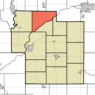
Adams Township is one of fourteen townships in Carroll County, Indiana. As of the 2020 census, its population was 495 and it contained 211 housing units.

<span class="mw-page-title-main">Buck Creek, Indiana</span> Census-designated place in Indiana, United States

Buck Creek is an unincorporated census-designated place in Washington Township, Tippecanoe County, in the U.S. state of Indiana.

<span class="mw-page-title-main">Deer Creek Township, Carroll County, Indiana</span> Township in Indiana, United States

Deer Creek Township is one of fourteen townships in Carroll County, Indiana. As of the 2020 census, its population was 4,566 and it contained 1,975 housing units.

References

  1. "Carroll County, Indiana". United States Census Bureau . Retrieved May 29, 2023.
  2. "Find a County". National Association of Counties. Archived from the original on May 31, 2011. Retrieved June 7, 2011.
  3. 1 2 "Government at Crossroads: An Indiana chronology". The Herald Bulletin . January 5, 2008. Retrieved July 22, 2009.
  4. Brill, Marlene Targ (2005). Indiana. Marshall Cavendish. p. 35. ISBN   978-0-7614-2020-0.
  5. 1 2 3 Odell, John Curtis (1916). History of Carroll County, Indiana: Its People, Industries and Institutions. B.F. Bowen. pp. 66–73.
  6. Gannett, Henry (1905). The Origin of Certain Place Names in the United States. Govt. Print. Off. pp.  70.
  7. Counts, Will; Jon Dilts (1991). The 92 Magnificent Indiana Courthouses. Bloomington, Indiana: Indiana University Press. pp. 22–23. ISBN   978-0-253-33638-5.
  8. Carroll County IN (Google Maps, accessed 21 September 2020)
  9. Carroll County High Point, Indiana (PeakBagger.com, accessed 21 September 2020)
  10. 1 2 "Population, Housing Units, Area, and Density: 2010 - County". US Census Bureau. Archived from the original on February 12, 2020. Retrieved July 10, 2015.
  11. 1 2 "Monthly Averages for Delphi, Indiana". The Weather Channel. Retrieved January 27, 2011.
  12. 1 2 Indiana Code. "Title 36, Article 2, Section 3". IN.gov. Retrieved September 16, 2008.
  13. 1 2 3 4 Indiana Code. "Title 2, Article 10, Section 2" (PDF). IN.gov. Retrieved September 16, 2008.
  14. "Indiana Senate Districts". State of Indiana. Retrieved January 23, 2011.
  15. "Indiana House Districts". State of Indiana. Retrieved January 23, 2011.
  16. Leip, David. "Atlas of US Presidential Elections". uselectionatlas.org. Retrieved May 14, 2018.
  17. "Annual Estimates of the Resident Population for Counties: April 1, 2020 to July 1, 2023". United States Census Bureau. Retrieved April 2, 2024.
  18. "US Decennial Census". US Census Bureau. Retrieved July 10, 2014.
  19. "Historical Census Browser". University of Virginia Library. Retrieved July 10, 2014.
  20. "Population of Counties by Decennial Census: 1900 to 1990". US Census Bureau. Retrieved July 10, 2014.
  21. "Census 2000 PHC-T-4. Ranking Tables for Counties: 1990 and 2000" (PDF). US Census Bureau. Retrieved July 10, 2014.
  22. "Carroll County QuickFacts". US Census Bureau. Archived from the original on June 7, 2011. Retrieved September 17, 2011.
  23. 1 2 3 "DP-1 Profile of General Population and Housing Characteristics: 2010 Demographic Profile Data". US Census Bureau. Archived from the original on February 13, 2020. Retrieved July 10, 2015.
  24. "Selected Social Characteristics in the US – 2006-2010 American Community Survey 5-Year Estimates". US Census Bureau. Archived from the original on February 14, 2020. Retrieved July 10, 2015.
  25. "Selected Economic Characteristics – 2006-2010 American Community Survey 5-Year Estimates". US Census Bureau. Archived from the original on February 14, 2020. Retrieved July 10, 2015.
  26. 1 2 "P2 HISPANIC OR LATINO, AND NOT HISPANIC OR LATINO BY RACE – 2020: DEC Redistricting Data (PL 94-171) – Carroll County, Indiana".
  27. "2020 CENSUS - SCHOOL DISTRICT REFERENCE MAP: Carroll County, IN" (PDF). U.S. Census Bureau . Retrieved July 22, 2022. - Text list
  28. "Delphi Community High School - Main". Archived from the original on October 7, 2006.
  29. "Delphi Community Middle School". Archived from the original on October 17, 2006.
  30. "Carroll Jr./Sr. High School". Archived from the original on October 6, 2006.
  31. "Office". Archived from the original on September 29, 2006.
  32. "Hillcrest Elementary". Archived from the original on September 29, 2006.

40°35′N86°34′W / 40.58°N 86.56°W / 40.58; -86.56