Huntington County | |
---|---|
Coordinates: 40°50′N85°29′W / 40.83°N 85.49°W | |
Country | United States |
State | Indiana |
Founded | February 2, 1832 (authorized) May 5, 1834 (organized) |
Named for | Samuel Huntington |
Seat | Huntington |
Largest city | Huntington |
Area | |
• Total | 387.72 sq mi (1,004.2 km2) |
• Land | 382.65 sq mi (991.1 km2) |
• Water | 5.07 sq mi (13.1 km2) 1.31% |
Population (2020) | |
• Total | 36,662 |
• Density | 95.8/sq mi (37.0/km2) |
Time zone | UTC−5 (Eastern) |
• Summer (DST) | UTC−4 (EDT) |
Congressional district | 3rd |
Website | www |
Indiana county number 35 |
Huntington County is a county in the U.S. state of Indiana. According to the 2020 United States Census, the population was 36,662. [1] The county seat (and only city) is Huntington. [2]
Huntington County comprises the Huntington, Indiana micropolitan statistical area and is included in the Fort Wayne–Huntington–Auburn Combined Statistical Area.
Huntington County was organized from the previously unorganized Indiana Territory and lands gained by the Adams New Purchase of 1818. The county's creation was authorized by an act of the Indiana state legislature dated February 2, 1832. Organization of the county's governing structure began on May 5, 1834. [3] The first non–Native American settlers in what has since become Huntington County were a group of 29 farm families from Connecticut who arrived in the early 1830s. These were "Yankee" settlers, meaning they were descended from the English Puritans who settled New England in the colonial era. These settlers were able to get to what has since become Huntington County due to the construction of the Wabash and Erie Canal, which was a shipping canal that connected the Great Lakes to the Ohio River by way of a manmade waterway. When they arrived in what has since become Huntington County, the settlers from Connecticut found dense virgin forest and wild prairie. The original 29 "Yankee" families from Connecticut laid out roads; built a post office; established post routes; and built a town hall, a church, and a schoolhouse from the trees in the area that they cut down. [4] The county was named for Samuel Huntington, who signed the Declaration of Independence and the Articles of Confederation. [5] He was also president of the Continental Congress under the Articles of Confederation.
The terrain of Huntington County consists of low rolling hills, completely devoted to agriculture or urban development. The Wabash River flows to the west through the upper-central part of the county, while the Salamonie River flows to the west through the lower part. [6] Its highest point (about 925 feet (282 m) above sea level) is at the southwest corner. [7] According to the 2010 census, the county has a total area of 387.72 square miles (1,004.2 km2), of which 382.65 square miles (991.1 km2) (or 98.69%) is land and 5.07 square miles (13.1 km2) (or 1.31%) is water. [8]
Huntington, Indiana | ||||||||||||||||||||||||||||||||||||||||||||||||||||||||||||
---|---|---|---|---|---|---|---|---|---|---|---|---|---|---|---|---|---|---|---|---|---|---|---|---|---|---|---|---|---|---|---|---|---|---|---|---|---|---|---|---|---|---|---|---|---|---|---|---|---|---|---|---|---|---|---|---|---|---|---|---|
Climate chart (explanation) | ||||||||||||||||||||||||||||||||||||||||||||||||||||||||||||
| ||||||||||||||||||||||||||||||||||||||||||||||||||||||||||||
|
In recent years, average temperatures in Huntington have ranged from a low of 16 °F (−9 °C) in January to a high of 87 °F (31 °C) in July, although a record low of −28 °F (−33 °C) was recorded in January 1982 and a record high of 105 °F (41 °C) was recorded in June 1988. Average monthly precipitation ranged from 1.82 inches (46 mm) in February to 4.37 inches (111 mm) in June. [9]
The county government is a constitutional body, and is granted specific powers by the Constitution of Indiana, and by the Indiana Code.
County Council: The fiscal branch of the county government; controls spending and revenue collection in the county. Representatives, elected to four-year terms from county districts, are responsible for setting salaries, the annual budget, and special spending. The council has limited authority to impose local taxes, in the form of an income and property tax that is subject to state level approval, excise taxes, and service taxes. [10] [11]
Board of Commissioners: The executive and legislative body of the county. The commissioners are elected county-wide to staggered four-year terms. One commissioner serves as president. The commissioners are charged with collecting revenue and managing the county government. [10] [11]
Court: The county maintains a small claims court that handles civil cases. The judge on the court is elected to a term of four years and must be a member of the Indiana Bar Association. The judge is assisted by a constable who is also elected to a four-year term. In some cases, court decisions can be appealed to the state level circuit court. [11]
County Officials: The county has other elected offices, including sheriff, coroner, auditor, treasurer, recorder, surveyor, and circuit court clerk. These officers are elected to four-year terms. Members elected to county government positions are required to declare party affiliations and to be residents of the county. [11]
Huntington County is part of Indiana's 3rd congressional district; Indiana Senate districts 17 and 19; [12] and Indiana House of Representatives district 50. [13]
Presidential Election Analysis: Huntington County has been strongly Republican; Lyndon B. Johnson was the last Democratic Party candidate to carry the county (1964).
Year | Republican | Democratic | Third party | |||
---|---|---|---|---|---|---|
No. | % | No. | % | No. | % | |
2020 | 13,147 | 73.57% | 4,255 | 23.81% | 468 | 2.62% |
2016 | 11,649 | 71.99% | 3,506 | 21.67% | 1,026 | 6.34% |
2012 | 10,862 | 68.76% | 4,596 | 29.09% | 339 | 2.15% |
2008 | 10,291 | 62.91% | 5,843 | 35.72% | 223 | 1.36% |
2004 | 11,617 | 74.34% | 3,877 | 24.81% | 133 | 0.85% |
2000 | 10,113 | 69.17% | 4,119 | 28.17% | 388 | 2.65% |
1996 | 8,275 | 58.79% | 4,287 | 30.46% | 1,513 | 10.75% |
1992 | 9,093 | 56.79% | 3,855 | 24.07% | 3,065 | 19.14% |
1988 | 11,675 | 74.87% | 3,873 | 24.84% | 46 | 0.29% |
1984 | 10,805 | 69.77% | 4,598 | 29.69% | 84 | 0.54% |
1980 | 9,497 | 59.59% | 5,415 | 33.98% | 1,025 | 6.43% |
1976 | 9,182 | 57.78% | 6,515 | 41.00% | 193 | 1.21% |
1972 | 10,858 | 68.48% | 4,908 | 30.96% | 89 | 0.56% |
1968 | 9,002 | 54.48% | 6,238 | 37.75% | 1,283 | 7.76% |
1964 | 7,438 | 44.16% | 9,308 | 55.26% | 98 | 0.58% |
1960 | 10,658 | 59.44% | 7,163 | 39.95% | 109 | 0.61% |
1956 | 11,024 | 64.15% | 6,027 | 35.07% | 133 | 0.77% |
1952 | 10,508 | 61.98% | 6,114 | 36.06% | 331 | 1.95% |
1948 | 8,178 | 52.01% | 7,202 | 45.81% | 343 | 2.18% |
1944 | 8,668 | 57.15% | 6,128 | 40.41% | 370 | 2.44% |
1940 | 9,110 | 55.22% | 7,220 | 43.77% | 167 | 1.01% |
1936 | 7,024 | 44.75% | 8,361 | 53.26% | 312 | 1.99% |
1932 | 6,791 | 42.92% | 8,697 | 54.97% | 333 | 2.10% |
1928 | 8,323 | 58.88% | 5,678 | 40.17% | 135 | 0.96% |
1924 | 7,437 | 51.42% | 5,506 | 38.07% | 1,519 | 10.50% |
1920 | 8,100 | 53.67% | 6,506 | 43.11% | 487 | 3.23% |
1916 | 3,761 | 45.73% | 3,833 | 46.60% | 631 | 7.67% |
1912 | 2,108 | 28.20% | 3,119 | 41.72% | 2,249 | 30.08% |
1908 | 3,973 | 47.62% | 3,712 | 44.49% | 659 | 7.90% |
1904 | 4,385 | 52.52% | 3,290 | 39.41% | 674 | 8.07% |
1900 | 4,122 | 50.96% | 3,691 | 45.64% | 275 | 3.40% |
1896 | 4,117 | 51.31% | 3,750 | 46.73% | 157 | 1.96% |
1892 | 3,384 | 46.66% | 3,460 | 47.70% | 409 | 5.64% |
1888 | 3,559 | 49.23% | 3,481 | 48.15% | 189 | 2.61% |
Census | Pop. | Note | %± |
---|---|---|---|
1840 | 1,579 | — | |
1850 | 7,850 | 397.2% | |
1860 | 14,867 | 89.4% | |
1870 | 19,036 | 28.0% | |
1880 | 21,805 | 14.5% | |
1890 | 27,644 | 26.8% | |
1900 | 28,901 | 4.5% | |
1910 | 28,982 | 0.3% | |
1920 | 31,671 | 9.3% | |
1930 | 29,073 | −8.2% | |
1940 | 29,931 | 3.0% | |
1950 | 31,400 | 4.9% | |
1960 | 33,814 | 7.7% | |
1970 | 34,970 | 3.4% | |
1980 | 35,596 | 1.8% | |
1990 | 35,427 | −0.5% | |
2000 | 38,075 | 7.5% | |
2010 | 37,124 | −2.5% | |
2020 | 36,662 | −1.2% | |
2023 (est.) | 36,781 | [15] | 0.3% |
US Decennial Census [16] 1790–1960 [17] 1900–1990 [18] 1990–2000 [19] 2010–2013 [1] |
As of the 2010 United States Census, there were 37,124 people, 14,218 households, and 10,074 families in the county. [20] The population density was 97.0 inhabitants per square mile (37.5/km2). There were 15,805 housing units at an average density of 41.3 per square mile (15.9/km2). [8] The racial makeup of the county was 97.1% white, 0.4% Asian, 0.4% American Indian, 0.4% black or African American, 0.5% from other races, and 1.1% from two or more races. Those of Hispanic or Latino origin made up 1.7% of the population. [20] In terms of ancestry, 37.9% were German, 14.9% were Irish, 12.9% were American, and 12.1% were English. [21]
Of the 14,218 households, 32.3% had children under the age of 18 living with them, 56.5% were married couples living together, 9.9% had a female householder with no husband present, 29.1% were non-families, and 24.4% of all households were made up of individuals. The average household size was 2.52 and the average family size was 2.97. The median age was 39.0 years. [20]
The median income for a household in the county was $47,697 and the median income for a family was $55,630. Males had a median income of $41,648 versus $30,218 for females. The per capita income for the county was $21,575. About 7.7% of families and 11.4% of the population were below the poverty line, including 15.6% of those under age 18 and 9.8% of those age 65 or over. [22]
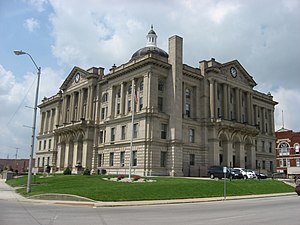
Whitley County is a rural county in the U.S. state of Indiana. As of the 2020 United States census, the population was 36,825. Whitley County is the 49th largest county in Indiana. The county seat is Columbia City. The county has the highest county number (92) on Indiana license plates, as it is alphabetically the last in the state's list of counties. It is part of the Fort Wayne Metropolitan Statistical Area and the Fort Wayne–Huntington–Auburn Combined Statistical Area.
Wells County is a county in the U.S. state of Indiana. As of the 2020 United States Census, the population was 28,180. The county seat is Bluffton.
Warrick County is a county located in the U.S. state of Indiana. As of 2020, the population was 63,898. The county seat is Boonville. It was organized in 1813 and was named for Captain Jacob Warrick, an Indiana militia company commander killed in the Battle of Tippecanoe in 1811. It is one of the ten fastest-growing counties in Indiana.
Wabash County is a county located in the northern central part of the U.S. state of Indiana. As of 2020, the population was 30,976. The county seat is Wabash.
Sullivan County is a county in the U.S. state of Indiana, and determined by the US Census Bureau to include the mean center of U.S. population in 1940. As of 2020, the population was 20,758. The county seat is Sullivan.
Posey County is the southernmost, southwesternmost, and westernmost county in the U.S. state of Indiana. Its southern border is formed by the Ohio River, and its western border by the Wabash River, a tributary to the Ohio. As of 2020, the population was 25,222. The county seat is Mount Vernon.
Miami County is a county located in the U.S. state of Indiana. As of 2020, the population was 35,962. The county seat is the City of Peru. Miami County is part of the Kokomo-Peru CSA.
Jay County is a county in the U.S. state of Indiana. As of 2020, the population was 20,478. The county seat is Portland.
Grant County is a county in central Indiana in the United States Midwest. At the time of the 2020 census, the population was 66,674. The county seat is Marion. Important paleontological discoveries, dating from the Pliocene epoch, have been made at the Pipe Creek Sinkhole in Grant County.
Delaware County is a county in the east central portion of the U.S. state of Indiana. As of 2020, the population was 111,903. The county seat is Muncie.
Carroll County is a county located in the U.S. state of Indiana. As of the 2020 United States Census, the population was 20,306. The county seat is Delphi.
Attica is a city in Logan Township, Fountain County, Indiana, United States.
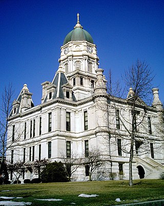
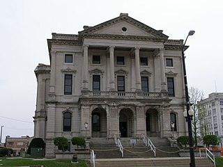
Huntington, known as the "Lime City", is the largest city in and the county seat of Huntington County, Indiana, United States. It is in Huntington and Union townships. It is also part of Fort Wayne, Indiana's metropolitan area. The population was 17,022 at the 2020 United States Census, down from 17,391 in the 2010 United States Census.
Markle is a town in Huntington and Wells counties, in the U.S. state of Indiana. The population was 1,071 at the 2020 census. It lies along Interstate 69, U.S. Route 224, State Road 116 and State Road 3.
Roanoke is a town in Jackson Township, Huntington County, Indiana, United States. The population was 1,762 at the 2020 census. Roanoke is governed by a town council. Town offices include the clerk treasurer, utilities department, police department, and volunteer fire department. The town has a public elementary school. WOWO and WRNP have transmitter towers in Roanoke, along U.S. Highway 24. For many years, television station WPTA was licensed to Roanoke, though that station's studios and transmitter have always been located in nearby Fort Wayne.
Warren is a town in Salamonie Township, Huntington County, Indiana. The population of Warren was 1,182 at the time of the 2020 census.
Perrysville is a town in Highland Township, Vermillion County, in the U.S. state of Indiana. The population was 456 at the 2010 census.
Lagro is a town in Lagro Township, Wabash County, in the U.S. state of Indiana. The population was 415 at the 2010 census.
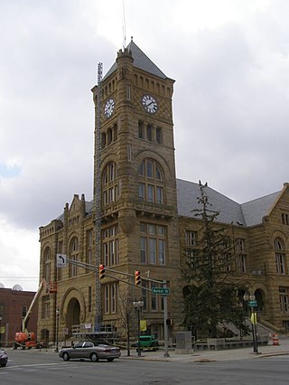
Wabash is a city in Noble Township, Wabash County, in the U.S. state of Indiana. The population was 10,666 at the 2010 census. The city is situated along the Wabash River in the county seat of Wabash County.
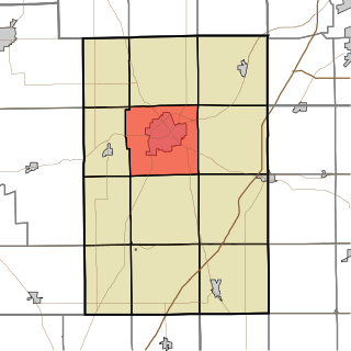
Huntington Township is one of twelve townships in Huntington County, Indiana. As of the 2020 census, its population was 20,326, making it the most populous township in the county.