Larwill, Indiana

Last updated

Larwill, Indiana
Dr. Christopher Souder House in Larwill.jpg
The historic Christopher Souder House
Whitley County Indiana Incorporated and Unincorporated areas Larwill Highlighted 1842282.svg
Location of Larwill in Whitley County, Indiana.
Coordinates: 41°10′47″N85°37′30″W / 41.17972°N 85.62500°W / 41.17972; -85.62500
Country United States
State Indiana
County Whitley
Township Richland
Area
[1]
  Total0.18 sq mi (0.46 km2)
  Land0.18 sq mi (0.46 km2)
  Water0.00 sq mi (0.00 km2)
Elevation
[2]
961 ft (293 m)
Population
 (2020)
  Total273
  Density1,525.14/sq mi (587.31/km2)
Time zone UTC-5 (Eastern (EST))
  Summer (DST) UTC-4 (EDT)
ZIP code
46764
Area code 260
FIPS code 18-42282 [3]
GNIS feature ID2396709 [2]
Website https://townoflarwill.org/

Larwill is a town in Richland Township, Whitley County, in the U.S. state of Indiana. [2] The population was 283 at the 2010 census.

Contents

History

Larwill was originally laid out and named Huntsville on November 13, 1854. On March 8, 1866, the town was renamed to Larwill in Honor of William and Joseph Larwill, who were railroad engineers. [4] The Larwill post office has been in operation since 1866. [5]

The Dr. Christopher Souder House was listed on the National Register of Historic Places in 2005. [6]

Geography

According to the 2010 census, Larwill has a total area of 0.22 square miles (0.57 km2), all land. [7]

Demographics

Historical population
CensusPop.Note
1880 506
1920 264
1930 252−4.5%
1940 31926.6%
1950 316−0.9%
1960 994214.6%
1970 324−67.4%
1980 286−11.7%
1990 219−23.4%
2000 28228.8%
2010 2830.4%
2020 273−3.5%
U.S. Decennial Census [8]

2010 census

As of the census [9] of 2010, there were 283 people, 100 households, and 69 families living in the town. The population density was 1,286.4 inhabitants per square mile (496.7/km2). There were 125 housing units at an average density of 568.2 per square mile (219.4/km2). The racial makeup of the town was 98.9% Non-Hispanic White and 1.1% from two or more races. There were 100 households, of which 33.0% had children under the age of 18 living with them, 41.0% were married couples living together, 16.0% had a female householder with no husband present, 12.0% had a male householder with no wife present, and 31.0% were non-families. 26.0% of all households were made up of individuals, and 13% had someone living alone who was 65 years of age or older. The average household size was 2.83 and the average family size was 3.36.

The median age in the town was 35.5 years. 26.1% of residents were under the age of 18; 12% were between the ages of 18 and 24; 23.3% were from 25 to 44; 27.6% were from 45 to 64; and 11% were 65 years of age or older. The gender makeup of the town was 49.1% male and 50.9% female.

2000 census

As of the census [3] of 2000, there were 282 people, 98 households, and 70 families living in the town. The population density was 1,266.9 inhabitants per square mile (489.2/km2). There were 106 housing units at an average density of 476.2 per square mile (183.9/km2). The racial makeup of the town was 98.94% White, 0.35% Asian, and 0.71% from two or more races.

There were 98 households, out of which 40.8% had children under the age of 18 living with them, 53.1% were married couples living together, 14.3% had a female householder with no husband present, and 27.6% were non-families. 24.5% of all households were made up of individuals, and 10.2% had someone living alone who was 65 years of age or older. The average household size was 2.88 and the average family size was 3.45.

In the town, the population was spread out, with 34.8% under the age of 18, 8.2% from 18 to 24, 32.3% from 25 to 44, 13.5% from 45 to 64, and 11.3% who were 65 years of age or older. The median age was 30 years. For every 100 females, there were 102.9 males. For every 100 females age 18 and over, there were 97.8 males.

The median income for a household in the town was $36,563, and the median income for a family was $40,556. Males had a median income of $29,167 versus $19,688 for females. The per capita income for the town was $13,154. About 13.2% of families and 10.7% of the population were below the poverty line, including 12.5% of those under the age of eighteen and 9.7% of those 65 or over.

Notable natives

Related Research Articles

<span class="mw-page-title-main">Zanesville, Indiana</span> Town in Indiana, United States

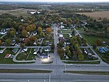
Zanesville is a town in Wells and Allen counties in the U.S. state of Indiana, southwest of Fort Wayne. The population was 580 at the 2020 Census, down from 600 at the 2010 census.

<span class="mw-page-title-main">St. Leon, Indiana</span> Town in Indiana, United States

St. Leon or Saint Leon is a town in Kelso Township, Dearborn County, Indiana, United States. The population was 678 at the 2010 census.

<span class="mw-page-title-main">Lyons, Indiana</span> Town in Indiana, United States

Lyons is a town in Washington Township, Greene County, Indiana, United States. The population was 742 at the 2010 census. It is part of the Bloomington, Indiana Metropolitan Statistical Area.

<span class="mw-page-title-main">Prince's Lakes, Indiana</span> Town in Indiana, United States

Prince's Lakes is a town in Nineveh Township, Johnson County, Indiana, United States. The population was 1,312 at the 2010 census.

<span class="mw-page-title-main">Weston, Maine</span> Town in the state of Maine, United States

Weston is a town in Aroostook County, Maine, United States. The population was 245 at the 2020 census.

Carrabassett Valley is a town in Franklin County, Maine, United States. The population was 673 at the 2020 census.

<span class="mw-page-title-main">Sidney, Maine</span> Town in the state of Maine, United States

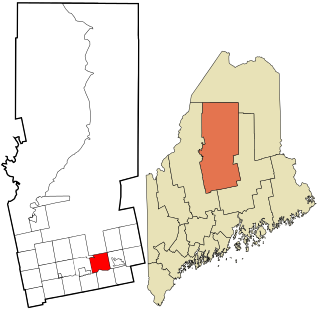
Sidney is a town in Kennebec County, Maine, United States. The population was 4,645 at the 2020 census. Sidney was incorporated as a town on January 30, 1792. The town was named for Sir Philip Sidney, an English author. Sidney is included in the Augusta, Maine micropolitan New England City and Town Area. Since 1937, the town has been the home of the New England Music Camp.

Lowell is a town in Penobscot County, Maine, United States. The population was 368 at the 2020 census.

<span class="mw-page-title-main">Sebec, Maine</span> Town in the state of Maine, United States

Sebec is a town in Piscataquis County, Maine, United States. The population was 665 at the 2020 census.

Detroit is a town in Somerset County, Maine, United States. The population was 885 at the 2020 census.

Palmyra is a town in Somerset County, Maine, United States. The population was 1,924 at the 2020 census.

<span class="mw-page-title-main">Burnham, Maine</span> Town in the state of Maine, United States

Burnham is a town in Waldo County, Maine, United States. The population was 1,096 at the 2020 census.

Charlotte is a town in Washington County, Maine, United States. The town was named for the wife of legislator William Vance. The population was 337 at the 2020 census.

<span class="mw-page-title-main">Whitneyville, Maine</span> Town in the state of Maine, United States

Whitneyville is a town in Washington County, Maine, United States. The town was named after Colonel Joseph Whitney, a mill owner. The population was 202 at the 2020 census.

<span class="mw-page-title-main">Brooklyn Heights, Missouri</span> Village in Missouri, United States

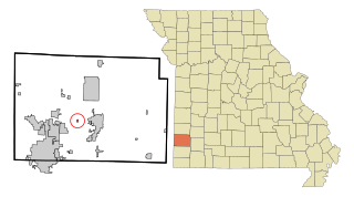
Brooklyn Heights is a village in Jasper County, Missouri, United States. The population was 101 at the 2020 census. It is part of the Joplin, Missouri Metropolitan Statistical Area.

<span class="mw-page-title-main">Scotsdale, Missouri</span> Village in Missouri, United States

Scotsdale is a village in Jefferson County, Missouri, United States. The population was 222 at the 2010 census.

<span class="mw-page-title-main">Hudson, South Dakota</span> Town in South Dakota, United States

Hudson is a town in Lincoln County, South Dakota, United States. The population was 311 at the 2020 census. It is the easternmost community in South Dakota.

<span class="mw-page-title-main">Leon, West Virginia</span> Town in West Virginia, United States

Leon is a town in Mason County, West Virginia, United States, situated along the Kanawha River. The population was 137 at the 2020 census. It is part of the Point Pleasant, WV–OH Micropolitan Statistical Area.

<span class="mw-page-title-main">Newburg, West Virginia</span> Town in West Virginia, United States

Newburg is a town in western Preston County, West Virginia, United States. The population was 275 at the 2020 census. It is part of the Morgantown metropolitan area.

<span class="mw-page-title-main">East Millinocket, Maine</span> Town in the state of Maine, United States

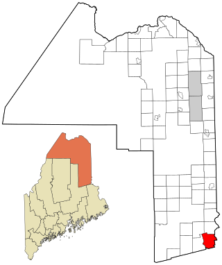
East Millinocket is a town in Penobscot County, Maine, United States. The population was 1,572 at the 2020 census.

References

  1. "2020 U.S. Gazetteer Files". United States Census Bureau. Retrieved March 16, 2022.
  2. 1 2 3 U.S. Geological Survey Geographic Names Information System: Larwill, Indiana
  3. 1 2 "U.S. Census website". United States Census Bureau . Retrieved January 31, 2008.
  4. "Profile for Larwill, IN". ePodunk . Retrieved July 6, 2016.
  5. "Whitley County". Jim Forte Postal History. Retrieved July 6, 2016.
  6. "National Register Information System". National Register of Historic Places . National Park Service. July 9, 2010.
  7. "G001 - Geographic Identifiers - 2010 Census Summary File 1". United States Census Bureau. Archived from the original on February 13, 2020. Retrieved July 17, 2015.
  8. "Census of Population and Housing". Census.gov. Retrieved June 4, 2015.
  9. "U.S. Census website". United States Census Bureau . Retrieved December 11, 2012.