Warren, Indiana

Last updated

Warren, Indiana
Town of Warren
Warren-indiana-from-above.jpg
Aerial view of Warren facing northeast
Huntington County Indiana Incorporated and Unincorporated areas Warren Highlighted 1880108.svg
Location of Warren in Huntington County, Indiana.
Coordinates: 40°41′16″N85°25′29″W / 40.68778°N 85.42472°W / 40.68778; -85.42472
Country United States
State Indiana
County Huntington
Township Salamonie
Area
[1]
  Total1.09 sq mi (2.82 km2)
  Land1.08 sq mi (2.80 km2)
  Water0.01 sq mi (0.01 km2)
Elevation
[2]
833 ft (254 m)
Population
 (2020)
  Total1,182
  Density1,091.41/sq mi (421.54/km2)
Time zone UTC-5 (Eastern (EST))
  Summer (DST) UTC-4 (EDT)
ZIP code
46792
Area code 260
FIPS code 18-80108 [3]
GNIS feature ID2397723 [2]
Website http://www.warrenindiana.com/index.html

Warren is a town in Salamonie Township, Huntington County, Indiana. The population of Warren was 1,182 at the time of the 2020 census.

Contents

History

Warren, originally known as "Jonesboro," was platted in 1833 near the Indianapolis & Ft. Wayne Road. In 1837, founder Samuel Jones sold his first lot. The name was later changed due to there being another town of Jonesboro nearby, south of Marion. The town experienced growth in 1878 when a new railroad line was built through the neighborhood. [4]

Geography

Warren is located along the Salamonie River. [5] The town lies just southeast of Interstate 69 between exits 273 and 278.

According to the 2010 census, Warren has a total area of 1.145 square miles (2.97 km2), of which 1.14 square miles (2.95 km2) (or 99.56%) is land and 0.005 square miles (0.01 km2) (or 0.44%) is water. [6]

Demographics

Historical population
CensusPop.Note
1880 503
1890 1,120122.7%
1900 1,52336.0%
1910 1,189−21.9%
1920 1,52027.8%
1930 1,177−22.6%
1940 1,38817.9%
1950 1,247−10.2%
1960 1,241−0.5%
1970 1,229−1.0%
1980 1,2542.0%
1990 1,185−5.5%
2000 1,2727.3%
2010 1,239−2.6%
2020 1,182−4.6%
U.S. Decennial Census [7]

2010 census

As of the census [8] of 2010, there were 1,239 people, 515 households, and 341 families living in the town. The population density was 1,086.8 inhabitants per square mile (419.6/km2). There were 600 housing units at an average density of 526.3 per square mile (203.2/km2). The racial makeup of the town was 98.8% White, 0.1% African American, 0.1% Native American, 0.2% Asian, 0.1% from other races, and 0.8% from two or more races. Hispanic or Latino of any race were 0.4% of the population.

There were 515 households, of which 29.5% had children under the age of 18 living with them, 52.2% were married couples living together, 11.3% had a female householder with no husband present, 2.7% had a male householder with no wife present, and 33.8% were non-families. 29.5% of all households were made up of individuals, and 11.6% had someone living alone who was 65 years of age or older. The average household size was 2.41 and the average family size was 2.96.

The median age in the town was 40.1 years. 24.9% of residents were under the age of 18; 8.2% were between the ages of 18 and 24; 22.6% were from 25 to 44; 25.5% were from 45 to 64; and 19% were 65 years of age or older. The gender makeup of the town was 49.4% male and 50.6% female.

2000 census

As of the census [3] of 2000, there were 1,272 people, 507 households, and 354 families living in the town. The population density was 1,395.1 inhabitants per square mile (538.7/km2). There were 558 housing units at an average density of 612.0 per square mile (236.3/km2). The racial makeup of the town was 98.82% White, 0.31% African American, 0.16% Native American, 0.08% Asian, 0.39% from other races, and 0.24% from two or more races. Hispanic or Latino of any race were 0.79% of the population.

There were 507 households, out of which 36.3% had children under the age of 18 living with them, 58.6% were married couples living together, 7.9% had a female householder with no husband present, and 30.0% were non-families. 25.8% of all households were made up of individuals, and 11.4% had someone living alone who was 65 years of age or older. The average household size was 2.51 and the average family size was 3.03.

In the town, the population was spread out, with 28.4% under the age of 18, 6.4% from 18 to 24, 28.6% from 25 to 44, 21.7% from 45 to 64, and 14.9% who were 65 years of age or older. The median age was 37 years. For every 100 females, there were 92.4 males. For every 100 females age 18 and over, there were 90.2 males.

The median income for a household in the town was $38,550, and the median income for a family was $41,917. Males had a median income of $33,229 versus $21,821 for females. The per capita income for the town was $17,145. About 2.0% of families and 3.1% of the population were below the poverty line, including 2.3% of those under age 18 and 8.1% of those age 65 or over.

Education

The Huntington County Community School Corporation operates Salamonie School, a K-5 school which is the only remaining school in Warren. The former Salamonie Township High School was consolidated into Huntington County Community High School, now known as Huntington North High School, in 1966. [9] Warren Elementary School operated in the old high school building for many years, its basketball team having adopted the old high school's nickname; "Lightning 5." However, the school was eventually closed and the nickname retired. The building served as the Knight Civic Center until the name was changed to its current name the "Knight Bergman Center".

The town has a lending library, the Warren Public Library. [10]

Notable people

Transportation

Important highways in Warren:

Points of interest

Related Research Articles

<span class="mw-page-title-main">Plainville, Indiana</span> Town in Indiana, United States

Plainville is a town in Steele Township, Daviess County, Indiana, United States. The population was 476 at the 2010 census. The former high school mascot was the Plainville Midgets.

<span class="mw-page-title-main">St. Leon, Indiana</span> Town in Indiana, United States

St. Leon or Saint Leon is a town in Kelso Township, Dearborn County, Indiana, United States. The population was 678 at the 2010 census.

<span class="mw-page-title-main">Eaton, Indiana</span> Town in Indiana, United States

Eaton is a town in Union Township, Delaware County, Indiana, along the Mississinewa River. The population was 1,595 at the 2020 census. It is part of the Muncie Metropolitan Statistical Area.

<span class="mw-page-title-main">Switz City, Indiana</span> Town in Indiana, United States

Switz City is a town in Fairplay and Grant townships, Greene County, Indiana, United States. The population was 293 at the 2010 census. It is part of the Bloomington, Indiana, Metropolitan Statistical Area.

<span class="mw-page-title-main">Andrews, Indiana</span> Town in Indiana, United States

Andrews is a town in Dallas Township, Huntington County, Indiana, United States. The population was 1,048 at the 2020 census.

<span class="mw-page-title-main">Huntington, Indiana</span> City in Huntington County, Indiana, United States

Huntington, known as the "Lime City", is the largest city in and the county seat of Huntington County, Indiana, United States. It is in Huntington and Union townships. It is also part of Fort Wayne, Indiana's metropolitan area. The population was 17,022 at the 2020 United States Census, down from 17,391 in the 2010 United States Census.

<span class="mw-page-title-main">Markle, Indiana</span> Town in Indiana, United States

Markle is a town in Huntington and Wells counties, in the U.S. state of Indiana. The population was 1,071 at the 2020 census. It lies along Interstate 69, U.S. Route 224, State Road 116 and State Road 3.

<span class="mw-page-title-main">Mount Etna, Indiana</span> Town in Indiana, United States

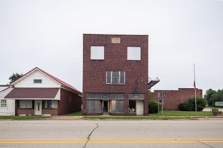
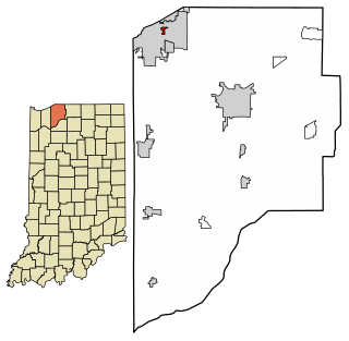
Mount Etna is a town in Huntington County, Indiana, United States. The population was 94 at the 2010 census. It lies at the intersection of four townships: Jefferson, Lancaster, Polk and Wayne.

<span class="mw-page-title-main">Roanoke, Indiana</span> Town in Indiana, United States

Roanoke is a town in Jackson Township, Huntington County, Indiana, United States. The population was 1,762 at the 2020 census. Roanoke is governed by a town council. Town offices include the clerk treasurer, utilities department, police department, and volunteer fire department. The town has a public elementary school. WOWO and WRNP have transmitter towers in Roanoke, along U.S. Highway 24. For many years, television station WPTA was licensed to Roanoke, though that station's studios and transmitter have always been located in nearby Fort Wayne.

<span class="mw-page-title-main">Salamonia, Indiana</span> Town in Indiana, United States

Salamonia is a town in Madison Township, Jay County, Indiana, United States. The population was 157 at the 2010 census. The town is situated along the Salamonie River, near its headwaters in Northern Indiana.

<span class="mw-page-title-main">New Chicago, Indiana</span> Town in Indiana, United States

New Chicago is a town in Hobart Township, Lake County, Indiana, United States. The population was 2,035 at the 2010 census.

<span class="mw-page-title-main">Winfield, Indiana</span> Town in Indiana, United States

Winfield is a town in Winfield Township, Lake County, Indiana. The population was 2,298 at the time of the 2000 census, 4,383 in 2010, and 5,987 in 2019. The town was incorporated in 1993 in order to keep the residents from being annexed by other neighboring communities. Prior to that time it had been part of Winfield Township as an unincorporated town. Winfield is named for General Winfield Scott. The town is served by the Crown Point post office and addresses in Winfield share the Crown Point ZIP code.

<span class="mw-page-title-main">Pottawattamie Park, Indiana</span> Town in Indiana, United States

Pottawattamie Park is a town in Michigan Township, LaPorte County, Indiana, United States. The population was 235 at the 2010 census. It is included in the Michigan City, Indiana-La Porte, Indiana Metropolitan Statistical Area.

<span class="mw-page-title-main">Amboy, Indiana</span> Town in Indiana, United States

Amboy is a town in Jackson Township, Miami County, in the U.S. state of Indiana. The population was 317 at the 2020 census, down from 384 in 2010.

<span class="mw-page-title-main">Avilla, Indiana</span> Town in Indiana, United States

Avilla is a town in Allen Township, Noble County, in the U.S. state of Indiana. The population was 2,401 at the 2010 census.

<span class="mw-page-title-main">Cloverdale, Indiana</span> Town in Indiana, United States

Cloverdale is a town in Cloverdale and Warren townships, Putnam County, in the U.S. state of Indiana. The population was 2,172 at the 2010 census.

<span class="mw-page-title-main">Lagro, Indiana</span> Town in Indiana, United States

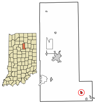
Lagro is a town in Lagro Township, Wabash County, in the U.S. state of Indiana. The population was 415 at the 2010 census.

<span class="mw-page-title-main">Spring Grove, Indiana</span> Town in Indiana, United States

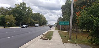
Spring Grove is a town in Wayne Township, Wayne County, in the U.S. state of Indiana. The population was 344 at the 2010 census.

<span class="mw-page-title-main">Warren Park, Indiana</span> Town in Indiana, United States

Warren Park is a town in Warren Township, Marion County, Indiana, United States. The population was 1,490 at the 2020 census. It has existed as an "included town" since 1970, when it was incorporated into Indianapolis as part of Unigov. It is part of Indianapolis, but retains a functioning town government under IC 36-3-1-11.

<span class="mw-page-title-main">Wynnedale, Indiana</span> Town in Indiana, United States

Wynnedale is a town in Washington Township, Marion County, Indiana, United States. The population was 215 at the 2020 census. It has existed as an "included town" since 1970, when it was incorporated into Indianapolis as part of Unigov. It is part of Indianapolis, but retains a functioning town government under IC 36-3-1-11.

References

  1. "2020 U.S. Gazetteer Files". United States Census Bureau. Retrieved March 16, 2022.
  2. 1 2 U.S. Geological Survey Geographic Names Information System: Warren, Indiana
  3. 1 2 "U.S. Census website". United States Census Bureau . Retrieved January 31, 2008.
  4. History of Huntington County, Indiana: From the Earliest Time to the Present. Brant & Fuller. 1887. pp.  795.
  5. DeLorme (1998). Indiana Atlas & Gazetteer. Yarmouth, Maine: DeLorme. ISBN   0-89933-211-0
  6. "G001 - Geographic Identifiers - 2010 Census Summary File 1". United States Census Bureau. Archived from the original on February 13, 2020. Retrieved July 25, 2015.
  7. "Indiana's Census 2020 Redistricting Data Dashboard". Census.gov. Retrieved August 13, 2021.
  8. "U.S. Census website". United States Census Bureau . Retrieved December 11, 2012.
  9. Huntington North High School.
  10. "Indiana public library directory" (PDF). Indiana State Library. Retrieved March 7, 2018.