Albion, Indiana | |
---|---|
Coordinates: 41°23′48″N85°25′07″W / 41.39667°N 85.41861°W [1] | |
Country | United States |
State | Indiana |
County | Noble |
Townships | Albion, Jefferson |
Area | |
• Total | 1.91 sq mi (4.94 km2) |
• Land | 1.91 sq mi (4.94 km2) |
• Water | 0.00 sq mi (0.00 km2) |
Elevation | 942 ft (287 m) |
Population (2020) | |
• Total | 2,222 |
• Density | 1,164.57/sq mi (449.63/km2) |
Time zone | UTC−5 (Eastern (EST)) |
• Summer (DST) | UTC−5 (EST) |
ZIP code | 46701 |
Area code | 260 |
FIPS code | 18-00820 |
GNIS ID | 2397423 [1] |
Website | www |
Albion is a town in Albion and Jefferson townships, Noble County, in the U.S. state of Indiana. [1] The population was 2,349 at the 2010 census. The city is the county seat of Noble County. [3]
Albion was laid out in 1846. [4] The town was named after Albion, New York. [5] A post office has been in operation at Albion since 1847. [6]
The Albion Courthouse Square Historic District, Noble County Courthouse, and Noble County Sheriff's House and Jail are listed on the National Register of Historic Places. [7]
According to the 2010 census, Albion has a total area of 1.91 square miles (4.95 km2), all land. [8]
Census | Pop. | Note | %± |
---|---|---|---|
1870 | 476 | — | |
1880 | 926 | 94.5% | |
1890 | 1,229 | 32.7% | |
1900 | 1,324 | 7.7% | |
1910 | 1,213 | −8.4% | |
1920 | 1,142 | −5.9% | |
1930 | 1,108 | −3.0% | |
1940 | 1,234 | 11.4% | |
1950 | 1,341 | 8.7% | |
1960 | 1,325 | −1.2% | |
1970 | 1,498 | 13.1% | |
1980 | 1,637 | 9.3% | |
1990 | 1,823 | 11.4% | |
2000 | 2,284 | 25.3% | |
2010 | 2,349 | 2.8% | |
2020 | 2,222 | −5.4% | |
U.S. Decennial Census [9] |
As of the 2010 census, [10] there were 2,349 people, 831 households, and 530 families living in the town. The population density was 1,229.8 inhabitants per square mile (474.8/km2). There were 951 housing units at an average density of 497.9 per square mile (192.2/km2). The racial makeup of the town was 97.4% White, 0.4% African American, 0.2% Native American, 0.4% Asian, 0.6% from other races, and 1.1% from two or more races. Hispanic or Latino of any race were 3.2% of the population.
There were 831 households, of which 35.7% had children under the age of 18 living with them, 44.0% were married couples living together, 14.4% had a female householder with no husband present, 5.3% had a male householder with no wife present, and 36.2% were non-families. 30.4% of all households were made up of individuals, and 12.2% had someone living alone who was 65 years of age or older. The average household size was 2.46 and the average family size was 3.04.
The median age in the town was 35.3 years. 24.8% of residents were under the age of 18; 8.8% were between the ages of 18 and 24; 30.1% were from 25 to 44; 22% were from 45 to 64; and 14.2% were 65 years of age or older. The gender makeup of the town was 51.1% male and 48.9% female.
As of the 2000 census, [11] there were 2,284 people, 846 households, and 555 families living in the town. The population density was 1,636.5 inhabitants per square mile (631.9/km2). There were 912 housing units at an average density of 653.5 per square mile (252.3/km2). The racial makeup of the town was 97.37% White, 0.92% African American, 0.35% Native American, 0.04% Asian, 0.88% from other races, and 0.44% from two or more races. Hispanic or Latino of any race were 1.31% of the population.
There were 846 households, out of which 37.1% had children under the age of 18 living with them, 47.8% were married couples living together, 12.6% had a female householder with no husband present, and 34.3% were non-families. 29.7% of all households were made up of individuals, and 10.2% had someone living alone who was 65 years of age or older. The average household size was 2.51 and the average family size was 3.10.
In the town, the population was spread out, with 29.2% under the age of 18, 10.3% from 18 to 24, 33.2% from 25 to 44, 17.0% from 45 to 64, and 10.2% who were 65 years of age or older. The median age was 30 years. For every 100 females, there were 110.7 males. For every 100 females age 18 and over, there were 108.2 males.
The median income for a household in the town was $36,282, and the median income for a family was $43,438. Males had a median income of $31,473 versus $23,531 for females. The per capita income for the town was $16,405. About 4.6% of families and 4.7% of the population were below the poverty line, including 6.7% of those under age 18 and 5.3% of those age 65 or over.
Children living in Albion go to either Central Noble High School, Central Noble Middle School, or Albion Elementary School.
Albion has a public library, a branch of the Noble County Public Library. [12]
Albion is located near Chain O'Lakes State Park.
Milltown is a town in Whiskey Run Township in Crawford County, Indiana and in Blue River and Spencer townships in Harrison County. The population was 818 at the time of the 2010 census.
Albany is a town in Delaware and Randolph counties in the U.S. state of Indiana, along the Mississinewa River. The population was 2,295 at the 2020 census. It is part of the Muncie, IN Metropolitan Statistical Area.
Laurel is a town in Laurel Township, Franklin County, Indiana, United States. The population was 512 at the 2010 census.
Shirley is a town in Brown Township, Hancock County and Greensboro Township, Henry County, Indiana, United States. The population was 830 at the 2010 census.
Wilkinson is a town in Brown Township, Hancock County, Indiana, United States. The population was 449 at the 2010 census.
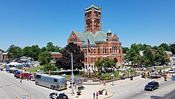
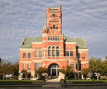
Brownstown is a town within Brownstown Township and the county seat of Jackson County, Indiana, United States. The population was 2,947 at the 2010 census. It was named for Jacob Brown, a general of the War of 1812.
New Whiteland is a town in Pleasant Township, Johnson County, Indiana, United States. The population was 5,550 at the 2020 census.
Silver Lake is a town in Lake Township, Kosciusko County, in the U.S. state of Indiana. The population was 915 at the 2010 census.
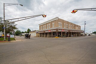
Topeka is a town in Clearspring and Eden townships, LaGrange County, Indiana, United States. The population was 1,153 at the 2010 census. Topeka is located approximately eleven miles south of Shipshewana, Indiana.
Wolcottville is a town in Orange Township, Noble County and Johnson Township, LaGrange County in the U.S. state of Indiana. The population was 998 at the 2010 census.
Woodlawn Heights is a town in Anderson Township, Madison County, Indiana, United States. It is part of the Indianapolis–Carmel–Anderson metropolitan statistical area. The population was 91 at the 2020 census.
Bethany is a town in Clay Township, Morgan County, in the U.S. state of Indiana. The population was 95 at the 2020 census.
Paragon is a town in Ray Township, Morgan County, in the U.S. state of Indiana. The population was 556 at the 2020 census, down from 659 in 2010.
Avilla is a town in Allen Township, Noble County, in the U.S. state of Indiana. The population was 2,401 at the 2010 census.
Cromwell is a town in Sparta Township, Noble County, in the U.S. state of Indiana. The population was 512 at the 2010 census.
Rome City is a town in Orange Township, Noble County, in the U.S. state of Indiana. The population was 1,361 at the 2010 census.
Francesville is a town in Salem Township, Pulaski County, in the U.S. state of Indiana. The population was 852 at the 2020 census. The motto for Francesville is “A small town with a big heart.”
Hudson is a town in Salem and Steuben townships, Steuben County, in the U.S. state of Indiana. The population was 518 at the 2010 census.
Shadeland is a town in Union Township, Tippecanoe County, in the U.S. state of Indiana. The population was 1,610 at the 2010 census.
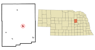
Albion is a city in and the county seat of Boone County, Nebraska, United States. The population was 1,650 at the 2010 census.
...via Albion, New York, home of a county commissioner.