Zanesville, Indiana | |
---|---|
Coordinates: 40°54′56″N85°16′50″W / 40.91556°N 85.28056°W | |
Country | United States |
State | Indiana |
Counties | Wells, Allen |
Township | Union, Lafayette |
Area | |
• Total | 0.84 sq mi (2.17 km2) |
• Land | 0.83 sq mi (2.14 km2) |
• Water | 0.01 sq mi (0.02 km2) |
Elevation | 824 ft (251 m) |
Population (2020) | |
• Total | 580 |
• Density | 700.48/sq mi (270.52/km2) |
Time zone | UTC-5 (Eastern (EST)) |
• Summer (DST) | UTC-4 (EDT) |
ZIP code | 46799 |
Area code | 260 |
FIPS code | 18-86318 [3] |
GNIS feature ID | 2397760 [2] |
Zanesville is a town in Wells and Allen counties in the U.S. state of Indiana, southwest of Fort Wayne. [2] The population was 580 at the 2020 Census, down from 600 at the 2010 census.
Zanesville was likely named after Zanesville, Ohio. [4]
A post office was established at Zanesville in 1854, and remained in operation until it was discontinued in 1964. [5] However, the United States Postal Service web site does note that a post office branch is currently in operation at 10917 Washington Street in Zanesville, with an assigned ZIP Code of 46799. [6]
According to the 2010 census, Zanesville has a total area of 0.83 square miles (2.15 km2), of which 0.82 square miles (2.12 km2) (or 98.8%) is land and 0.01 square miles (0.03 km2) (or 1.2%) is water. [7]
Census | Pop. | Note | %± |
---|---|---|---|
1880 | 93 | — | |
2000 | 602 | — | |
2010 | 600 | −0.3% | |
2020 | 580 | −3.3% | |
U.S. Decennial Census [8] |
As of the census [9] of 2010, there were 600 people, 229 households, and 175 families living in the town. The population density was 731.7 inhabitants per square mile (282.5/km2). There were 239 housing units at an average density of 291.5 per square mile (112.5/km2). The racial makeup of the town was 98.5% White, 0.2% African American, 0.2% Native American, 0.2% from other races, and 1.0% from two or more races. Hispanic or Latino of any race were 1.5% of the population.
There were 229 households, of which 38.0% had children under the age of 18 living with them, 62.4% were married couples living together, 9.2% had a female householder with no husband present, 4.8% had a male householder with no wife present, and 23.6% were non-families. 18.8% of all households were made up of individuals, and 8.7% had someone living alone who was 65 years of age or older. The average household size was 2.62 and the average family size was 3.01.
The median age in the town was 38.3 years. 27.2% of residents were under the age of 18; 6.5% were between the ages of 18 and 24; 25.3% were from 25 to 44; 28.1% were from 45 to 64; and 12.8% were 65 years of age or older. The gender makeup of the town was 49.7% male and 50.3% female.
As of the census [3] of 2000, there were 602 people, 212 households, and 172 families living in the town. The population density was 806.6 inhabitants per square mile (311.4/km2). There were 232 housing units at an average density of 310.8 per square mile (120.0/km2). The racial makeup of the town was 99.17% White, 0.17% Native American, 0.17% from other races, and 0.50% from two or more races. Hispanic or Latino of any race were 0.17% of the population.
There were 212 households, out of which 40.1% had children under the age of 18 living with them, 70.3% were married couples living together, 9.0% had a female householder with no husband present, and 18.4% were non-families. 15.1% of all households were made up of individuals, and 3.3% had someone living alone who was 65 years of age or older. The average household size was 2.84 and the average family size was 3.13.
In the town, the population was spread out, with 29.2% under the age of 18, 8.0% from 18 to 24, 29.9% from 25 to 44, 23.8% from 45 to 64, and 9.1% who were 65 years of age or older. The median age was 35 years. For every 100 females, there were 96.1 males. For every 100 females age 18 and over, there were 97.2 males.
The median income for a household in the town was $57,727, and the median income for a family was $58,375. Males had a median income of $40,893 versus $22,500 for females. The per capita income for the town was $20,606. About 4.6% of families and 4.9% of the population were below the poverty line, including 6.1% of those under age 18 and 10.0% of those age 65 or over.
Year | Republican | Democratic | Third Parties |
---|---|---|---|
2016 | 77.08%37 | 16.67% 8 | 6.25% 3 |
2012 | 75.%30 | 22.5% 9 | 2.5% 1 |
2008 | 47.5% 19 | 52.5%21 | 0% 0 |
These results do not represent all of Zanesville, only the Zanesville precinct of Allen County, which contains all of Zanesville north of the county-line, however most of Zanesville residents live in Wells County.
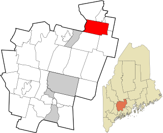
Eagle Lake is a town in Aroostook County, Maine, United States. The population was 772 at the 2020 census. The town was named by a body of troops heading from Bangor to the Aroostook War for the many eagles that they saw around the lake. A total of 49.0% of the population speaks French, reflecting a trend in Northeastern Maine.
Mapleton is a town in Aroostook County, Maine, United States. The population was 1,886 at the 2020 census.
Sherman is a town in Aroostook County, Maine, United States. The population was 815 at the 2020 census.
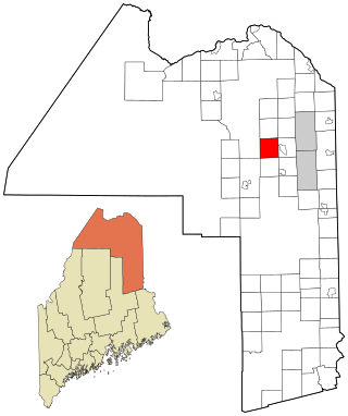
Wade is a town in Aroostook County, Maine, United States. The population was 229 at the 2020 census.
Chesterville is a town in Franklin County, Maine, United States. The population was 1,328 at the 2020 census.
Penobscot is a town in Hancock County, Maine, United States. The Bagaduce River flows through the town. The population was 1,136 at the 2020 census.
Benton is a town in Kennebec County, Maine, United States. It was formed in 1842, as a subdivision of the town of Clinton. The population was 2,715 at the 2020 census. The town was named for Missouri Senator Thomas Hart Benton.
Vienna is a town in Kennebec County, Maine, United States. The population was 578 at the 2020 census.
Hartford is a town in Oxford County, Maine, United States. Hartford is included in the Lewiston-Auburn, Maine metropolitan New England City and Town Area. The population was 1,203 at the 2020 census.
Stoneham is a town in Oxford County, Maine, United States. The population was 261 at the 2020 census.
Bradley is a town in Penobscot County, Maine, United States. It is part of the Bangor Metropolitan Statistical Area. The population was 1,532 at the 2020 census. The village of Bradley is in the northwestern corner of the town.
Canaan is a town in Somerset County, Maine, United States. The population was 2,193 at the 2020 census.
Detroit is a town in Somerset County, Maine, United States. The population was 885 at the 2020 census.
Smithfield is a town in Somerset County, Maine, United States. The population was 925 at the 2020 census. The town was incorporated on February 29, 1840 making it the only town in Maine incorporated on Leap Day. The town was named after the Rev. Henry Smith, an early settler.
Burnham is a town in Waldo County, Maine, United States. The population was 1,096 at the 2020 census.
Adamsville is a village in Muskingum County, Ohio, United States. The population was 140 at the 2020 census. It is part of the Zanesville micropolitan area.
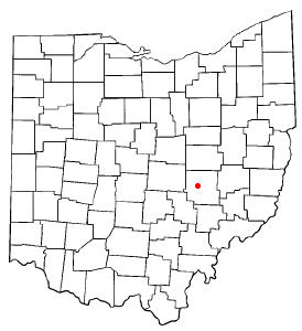
North Zanesville is a census-designated place (CDP) in Muskingum County, Ohio, United States, just north of the city of Zanesville, along the Muskingum River. The population was 3,116 at the 2020 census.
South Zanesville is a village in Muskingum County, Ohio, United States, along the Muskingum River near the mouth of the Moxahala Creek. The population was 1,894 at the 2020 census. It is part of the Zanesville micropolitan area.
Pine Grove is a town in Wetzel County, West Virginia, United States. The population was 363 at the 2020 census. The community was named for a grove of pine trees near the original town site.
East Millinocket is a town in Penobscot County, Maine, United States. The population was 1,572 at the 2020 census.