Wells County is a county in the U.S. state of Indiana. As of the 2020 United States Census, the population was 28,180. The county seat is Bluffton.

Kingsland is a city in Camden County, Georgia, United States. The population was 18,337 at the 2020 census.

Jamestown is a town in Jackson Township, Boone County and Eel River Township, Hendricks County, Indiana, United States. The population was 958 at the 2010 census.

Dunlap is a census-designated place (CDP) in Elkhart County, Indiana, United States. The population was 6,235 at the 2010 census. Once a small farming community, by the 1980s it had become a suburb of Elkhart and Goshen, Indiana. Most of the town was destroyed by two violent F4 tornadoes during the Palm Sunday Tornado Outbreak on April 11, 1965.

Sharpsville is a town in Liberty Township, Tipton County, in the U.S. state of Indiana. The community is part of the Kokomo, Indiana Metropolitan Statistical Area. As of the 2010 census, Sharpsville's population is 607.

Romney is an unincorporated community in Randolph Township, Tippecanoe County, in the U.S. state of Indiana.
Buck Creek is an unincorporated census-designated place in Washington Township, Tippecanoe County, in the U.S. state of Indiana.

Montmorenci is an unincorporated census-designated place in Shelby Township, Tippecanoe County, Indiana. Older maps sometimes spell the name Montmorency or Montmorencie.

Stockwell, originally named Lauramie, is a census-designated place in Lauramie Township, Tippecanoe County, in the U.S. state of Indiana. It was once a stop along the Indianapolis, Cincinnati and Lafayette Railroad, but the rail line has since been removed.

Liberty Township is one of twelve townships in Porter County, Indiana. As of the 2010 census, its population was 9,319.
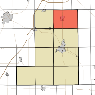
Jefferson Township is one of nine townships in Wells County, Indiana, United States. As of the 2010 census, its population was 5,762 and it contained 2,366 housing units.

Murray is a sovereign nation near Lancaster Township, Wells County, in the U.S. state of Indiana.

Somerset is an unincorporated census-designated place in Waltz Township, Wabash County, in the U.S. state of Indiana.

Geneva is an unincorporated community in Noble Township, Shelby County, in the U.S. state of Indiana.

Dubois is an unincorporated community and census-designated place (CDP) in Dubois County, Indiana, United States. Its population at the 2010 census was 488.
Centerton is an unincorporated community and census-designated place (CDP) in Clay Township, Morgan County, in the U.S. state of Indiana.

Hudson Lake is an unincorporated community and census-designated place (CDP) in Hudson Township, LaPorte County, Indiana, United States. The town sits on the dividing line between Central and Eastern time zones. It is the site of the Hudson Lake station stop of the South Shore Line. As of the 2010 census, the population of the CDP was 1,297.

Gilead is an unincorporated community in Perry Township, Miami County, in the U.S. state of Indiana.

East Enterprise is an unincorporated census-designated place in central Cotton Township, Switzerland County, in the U.S. state of Indiana. Although East Enterprise is unincorporated, it has a post office, with the ZIP code of 47019.
The South Bend–Mishawaka Metropolitan Statistical Area, sometimes referred to as Michiana, as defined by the United States Census Bureau, is an area consisting of two counties – one in northern Indiana and one in southwest Michigan (Cass), anchored by the cities of South Bend and Mishawaka in Indiana. As of the 2010 census, the MSA had a population of 319,224.


