Uniondale, Indiana

Last updated

Uniondale, Indiana
Union dale postoffice.jpg
Uniondale post office in 2012
Wells County Indiana Incorporated and Unincorporated areas Uniondale Highlighted 1877786.svg
Location of Uniondale in Wells County, Indiana.
Coordinates: 40°49′48″N85°14′27″W / 40.83000°N 85.24083°W / 40.83000; -85.24083
Country United States
State Indiana
County Wells
Township Union, Rockcreek
Government
  Type Mayor-council government
   Mayor Ronald K. Sliger (R)
Area
[1]
  Total0.21 sq mi (0.55 km2)
  Land0.21 sq mi (0.54 km2)
  Water0.00 sq mi (0.01 km2)
Elevation
[2]
814 ft (248 m)
Population
 (2020)
  Total271
  Density1,290.48/sq mi (498.58/km2)
Time zone UTC-5 (Eastern (EST))
  Summer (DST) UTC-4 (EDT)
ZIP code
46791
Area code 260
FIPS code 18-77786 [3]
GNIS feature ID2397705 [2]

Uniondale is a town in Union and Rockcreek townships, Wells County, in the U.S. state of Indiana. [2] The population was 310 at the 2010 census, down from 271 at the 2020 Census.

Contents

History

The Uniondale post office has been in operation since 1886. [4]

Notable people of the town include Halie McMillan [5] and Benjamin Stephens. [6]

Geography

According to the 2010 census, Uniondale has a total area of 0.212 square miles (0.55 km2), of which 0.21 square miles (0.54 km2) (or 99.06%) is land and 0.002 square miles (0.01 km2) (or 0.94%) is water. [7]

Demographics

Historical population
CensusPop.Note
1910 189
1920 25736.0%
1930 226−12.1%
1940 30133.2%
1950 293−2.7%
1960 3116.1%
1970 34912.2%
1980 303−13.2%
1990 289−4.6%
2000 277−4.2%
2010 31011.9%
2020 271−12.6%
U.S. Decennial Census [8]

2010 census

As of the census [9] of 2010, there were 310 people, 119 households, and 83 families living in the town. The population density was 1,476.2 inhabitants per square mile (570.0/km2). There were 126 housing units at an average density of 600.0 per square mile (231.7/km2). The racial makeup of the town was 96.8% White, 0.3% African American, 0.3% Native American, 1.9% Asian, and 0.6% from two or more races. Hispanic or Latino of any race were 1.0% of the population.

There were 119 households, of which 34.5% had children under the age of 18 living with them, 55.5% were married couples living together, 10.1% had a female householder with no husband present, 4.2% had a male householder with no wife present, and 30.3% were non-families. 26.9% of all households were made up of individuals, and 7.5% had someone living alone who was 65 years of age or older. The average household size was 2.61 and the average family size was 3.13.

The median age in the town was 37.4 years. 25.2% of residents were under the age of 18; 12.3% were between the ages of 18 and 24; 22.6% were from 25 to 44; 27.7% were from 45 to 64; and 12.3% were 65 years of age or older. The gender makeup of the town was 49.0% male and 51.0% female.

2000 census

As of the census [3] of 2000, there were 277 people, 109 households, and 74 families living in the town. The population density was 1,280.9 inhabitants per square mile (494.6/km2). There were 115 housing units at an average density of 531.8 per square mile (205.3/km2). The racial makeup of the town was 99.64% White and 0.36% Asian.

There were 109 households, out of which 35.8% had children under the age of 18 living with them, 51.4% were married couples living together, 12.8% had a female householder with no husband present, and 31.2% were non-families. 29.4% of all households were made up of individuals, and 16.5% had someone living alone who was 65 years of age or older. The average household size was 2.54 and the average family size was 3.19.

In the town, the population was spread out, with 27.8% under the age of 18, 8.3% from 18 to 24, 26.7% from 25 to 44, 20.2% from 45 to 64, and 17.0% who were 65 years of age or older. The median age was 38 years. For every 100 females, there were 99.3 males. For every 100 females age 18 and over, there were 90.5 males.

The median income for a household in the town was $40,469, and the median income for a family was $48,750. Males had a median income of $38,571 versus $22,500 for females. The per capita income for the town was $18,743. About 2.7% of families and 2.3% of the population were below the poverty line, including 5.6% of those under the age of eighteen and none of those 65 or over.

Related Research Articles

<span class="mw-page-title-main">Dyer Brook, Maine</span> Town in the state of Maine, United States

Dyer Brook is a town in Aroostook County, Maine, United States. The population was 215 at the 2020 census. Dyer Brook is also host to the local school, Southern Aroostook Community School.

<span class="mw-page-title-main">Eagle Lake, Maine</span> Town in the state of Maine, United States

Eagle Lake is a town in Aroostook County, Maine, United States. The population was 772 at the 2020 census. The town was named by a body of troops heading from Bangor to the Aroostook War for the many eagles that they saw around the lake. A total of 49.0% of the population speaks French, reflecting a trend in Northeastern Maine.

<span class="mw-page-title-main">Hersey, Maine</span> Town in the state of Maine, United States

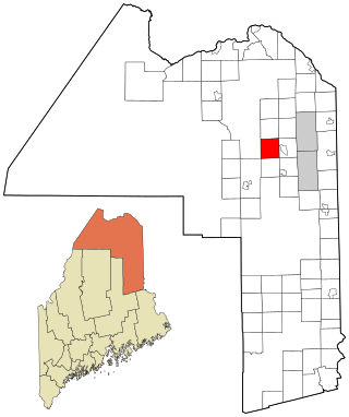
Hersey is a town in Aroostook County, Maine, United States. The population was 73 at the 2020 census.

<span class="mw-page-title-main">Mapleton, Maine</span> Town in the state of Maine, United States

Mapleton is a town in Aroostook County, Maine, United States. The population was 1,886 at the 2020 census.

<span class="mw-page-title-main">Merrill, Maine</span> Town in the state of Maine, United States

Merrill is a town in Aroostook County, Maine, United States. The population was 208 at the 2020 census.

<span class="mw-page-title-main">New Canada, Maine</span> Town in the state of Maine, United States

New Canada is a town in Aroostook County, Maine, United States. The population was 310 at the 2020 census.

<span class="mw-page-title-main">Perham, Maine</span> Town in the state of Maine, United States

Perham is a town in Aroostook County, Maine, United States. The population was 371 at the 2020 census. The town was named after Maine's 33rd governor, Sidney Perham.

<span class="mw-page-title-main">Sherman, Maine</span> Town in the state of Maine, United States

Sherman is a town in Aroostook County, Maine, United States. The population was 815 at the 2020 census.

<span class="mw-page-title-main">Stockholm, Maine</span> Town in the state of Maine, United States

Stockholm is a town in Aroostook County, Maine, United States. The population was 250 at the 2020 census.

<span class="mw-page-title-main">Wade, Maine</span> Town in the state of Maine, United States

Wade is a town in Aroostook County, Maine, United States. The population was 229 at the 2020 census.

<span class="mw-page-title-main">Westfield, Maine</span> Town in the state of Maine, United States

Westfield is a town in Aroostook County, Maine, United States. The population was 455 at the 2020 census.

<span class="mw-page-title-main">Chesterville, Maine</span> Town in Maine, United States

Chesterville is a town in Franklin County, Maine, United States. The population was 1,328 at the 2020 census.

Bradley is a town in Penobscot County, Maine, United States. It is part of the Bangor Metropolitan Statistical Area. The population was 1,532 at the 2020 census. The village of Bradley is in the northwestern corner of the town.

Detroit is a town in Somerset County, Maine, United States. The population was 885 at the 2020 census.

Meddybemps is a town in Washington County, Maine, United States. The population was 139 at the 2020 census.

<span class="mw-page-title-main">Worthington, West Virginia</span> Town in West Virginia, United States

Worthington is a town in Marion County, West Virginia, United States. The population was 158 at the 2010 census. Worthington was incorporated in 1893 and named for Colonel George Worthington, an early settler. U.S. Route 19 passes through the town.

<span class="mw-page-title-main">Newburg, West Virginia</span> Town in West Virginia, United States

Newburg is a town in western Preston County, West Virginia, United States. The population was 275 at the 2020 census. It is part of the Morgantown metropolitan area.

<span class="mw-page-title-main">Bancroft, West Virginia</span> Town in West Virginia, United States

Bancroft is a town in Putnam County, West Virginia, United States, along the Kanawha River. The population was 389 at the 2020 census. It is part of the Huntington–Ashland metropolitan area.

<span class="mw-page-title-main">Pine Grove, West Virginia</span> Town in West Virginia, United States

Pine Grove is a town in Wetzel County, West Virginia, United States. The population was 363 at the 2020 census. The community was named for a grove of pine trees near the original town site.

<span class="mw-page-title-main">North Hills, West Virginia</span> Town in West Virginia, United States

North Hills is a town in Wood County, West Virginia, United States. It is a suburb of Parkersburg. The population was 837 at the 2020 census. North Hills was incorporated on February 15, 1979.

References

  1. "2020 U.S. Gazetteer Files". United States Census Bureau. Retrieved March 16, 2022.
  2. 1 2 3 U.S. Geological Survey Geographic Names Information System: Uniondale, Indiana
  3. 1 2 "U.S. Census website". United States Census Bureau . Retrieved January 31, 2008.
  4. "Wells County". Jim Forte Postal History. Retrieved July 6, 2016.
  5. "University of Saint Francis Athletics: Halie McMillan - 2016 Volleyball". MaxPreps.com. Retrieved December 17, 2016.
  6. "Norwell High School Awards" (PDF). Retrieved May 27, 2021.
  7. "G001 - Geographic Identifiers - 2010 Census Summary File 1". United States Census Bureau. Archived from the original on February 13, 2020. Retrieved July 25, 2015.
  8. "Census of Population and Housing". Census.gov. Retrieved June 4, 2015.
  9. "U.S. Census website". United States Census Bureau . Retrieved December 11, 2012.