Greenville is the name of several places:

Greenville County is located in the U.S. state of South Carolina. As of the 2020 census, the population was 525,534, making it the most populous county in the state. Its county seat is Greenville. The county is also home to the Greenville County School District, the largest school system in South Carolina. County government is headquartered at Greenville County Square.

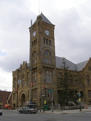
Darke County is a county in the U.S. state of Ohio. As of the 2020 census, the population was 51,881. Its county seat and largest city is Greenville. The county was created in 1809 and later organized in 1817. It is named for William Darke, an officer in the American Revolutionary War. Darke County comprises the Greenville, OH Micropolitan Statistical Area, which is also included in the Dayton-Springfield-Sidney, OH Combined Statistical Area.
Wells County is a county in the U.S. state of Indiana. As of the 2020 United States Census, the population was 28,180. The county seat is Bluffton.

Greenville is an incorporated town in Floyd County, Indiana. The population was 595 at the 2010 census. Greenville is located in the greater Louisville metropolitan area.

Greenville is the county seat and most populous city of Pitt County, North Carolina, United States. It is the principal city of the Greenville, NC Metropolitan Statistical Area, and the 12th-most populous city in North Carolina. Greenville is the health, entertainment, and educational hub of North Carolina's Tidewater and Coastal Plain. As of the 2020 census, there were 87,521 people in the city. The city has continued to see a population increase with a majority of the influx being seen during the 20th and early 21st centuries.
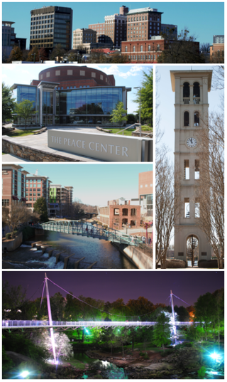
Greenville is a city in and the county seat of Greenville County, South Carolina, United States. With a population of 70,720 at the 2020 census, it is the 6th-most populous city in the state. Greenville is located approximately halfway between Atlanta, Georgia, and Charlotte, North Carolina, along Interstate 85. Its metropolitan area also includes Interstates 185 and 385. Greenville is the anchor city of the Upstate, a combined statistical area with a population of 1,487,610 at the 2020 census. Greenville was the fourth fastest-growing city in the United States between 2015 and 2016, according to the U.S. Census Bureau.

The Northwest Territory, also known as the Old Northwest and formally known as the Territory Northwest of the River Ohio, was formed from unorganized western territory of the United States after the American Revolution. Established in 1787 by the Congress of the Confederation through the Northwest Ordinance, it was the nation's first post-colonial organized incorporated territory.

The Treaty of Greenville, also known to Americans as the Treaty with the Wyandots, etc., but formally titled A treaty of peace between the United States of America, and the tribes of Indians called the Wyandots, Delawares, Shawanees, Ottawas, Chippewas, Pattawatimas, Miamis, Eel Rivers, Weas, Kickapoos, Piankeshaws, and Kaskaskias was a 1795 treaty between the United States and indigenous nations of the Northwest Territory, including the Wyandot and Delaware peoples, that redefined the boundary between indigenous peoples' lands and territory for European American community settlement.

The Stillwater River is a 69.3-mile-long (111.5 km) tributary of the Great Miami River in western Ohio in the United States. Via the Great Miami and Ohio rivers, it is part of the Mississippi River watershed.

The Miami Valley is the land area surrounding the Great Miami River in southwest Ohio, USA, and includes the Little Miami, Mad, and Stillwater rivers as well. Geographically, it includes Dayton, Springfield, Middletown, Hamilton, and other communities. The name is derived from the Miami Indians.

State Route 29 is an east–west state highway in the west-central portion of the U.S. state of Ohio. Its western terminus is at the Indiana state line near Celina, where State Road 67 continues west. It continues east to St. Marys where it junctions with U.S. Route 33. In that town, it also crosses State Route 66, State Route 116, and State Route 703, which was its former alignment before a divided highway was built. After turning south it crosses State Route 219 in New Knoxville and then has an interchange with Interstate 75, continuing into Sidney where it meets State Route 47. Still going southeast, it briefly joins State Route 235 before turning east and then south again to enter Urbana. Here the route joins U.S. Route 36, and the concurrency intersects with U.S. Route 68 and State Route 54. From there, State Route 29 leaves U.S. Route 36 and continues to Mutual, intersecting with State Route 161, and State Route 56 shortly after; later, in Mechanicsburg, the route intersects with State Route 4. The route then intersects with State Route 38, U.S. Route 42, and Interstate 70 before reaching its eastern terminus at U.S. Route 40 on the western edge of West Jefferson.

Greenville Creek is a 44.4-mile-long (71.5 km) tributary of the Stillwater River in southwestern Ohio in the United States. Via the Stillwater River, the Great Miami River, and the Ohio River, its water flows to the Mississippi River and ultimately the Gulf of Mexico. The creek starts in extreme eastern Indiana in Randolph County. It soon flows into Darke County, Ohio, and joins with a tributary that also starts in Indiana, Dismal Creek. It flows through Greenville and Gettysburg before entering Miami County. Near its confluence with the Stillwater River at Covington it drops 20 feet (6.1 m) at Greenville Falls in a glacially-cut gorge that is a state nature preserve.

Greenville Township is one of five townships in Floyd County, Indiana. As of the 2010 census, its population was 6,746 and it contained 2,532 housing units.

Chester Township is one of nine townships in Wells County, Indiana, United States. As of the 2010 census, its population was 936 and it contained 394 housing units.

State Route 571 is an east–west state highway in west-central Ohio, part of a statewide road transportation system. It indirectly connects the cities of Union City and Greenville with Springfield via a final 10.7 miles (17.2 km) on U.S. Route 40.

Williams is an unincorporated community in Root Township, Adams County, in the U.S. state of Indiana.

Greenville is an unincorporated community in northern Cass Township, Sullivan County, in the U.S. state of Indiana.


