Ossian, Indiana

Last updated

Ossian, Indiana
Town of Ossian
Motto: 
"Handed Down From Generation To Generation"
Wells County Indiana Incorporated and Unincorporated areas Ossian Highlighted 1857168.svg
Location of Ossian in Wells County, Indiana.
Coordinates: 40°52′25″N85°10′06″W / 40.87361°N 85.16833°W / 40.87361; -85.16833
Country United States
State Indiana
County Wells
Township Jefferson
Area
[1]
  Total1.68 sq mi (4.34 km2)
  Land1.67 sq mi (4.31 km2)
  Water0.01 sq mi (0.03 km2)
Elevation
[2]
827 ft (252 m)
Population
 (2020)
  Total3,266
  Density1,960.38/sq mi (757.05/km2)
Time zone UTC-5 (Eastern (EST))
  Summer (DST) UTC-4 (EDT)
ZIP code
46777
Area code 260
FIPS code 18-57168 [3]
GNIS feature ID2396840 [2]
Website http://www.ossianin.com/

Ossian is a town in Jefferson Township, Wells County, in the U.S. state of Indiana. [2] The town was named after Ossian, the narrator of a cycle of epic poems by the Scottish poet James Macpherson. [4] The population was 3,289 at the 2010 census.

Contents

History

The Ossian post office has been in operation since 1850. [5] In 1843, Indiana State Road 1 was made serviceable from Fort Wayne to Bluffton. On January 25, 1850, the Fort Wayne and Bluffton Plank Road Company was then organized. The plank road was a toll road; any horse or horse-drawn vehicle had to pay a toll. The Fort Wayne, Cincinnati, & Louisville Railroad was built through Ossian in 1869, though it was not in complete operation until the following year. Today, the railroad is a significant north–south route for the Norfolk Southern Corporation. Ossian is still served by Indiana State Road 1, while four miles north is Interstate 469, the beltway around Fort Wayne, and also just seven miles south of Fort Wayne International Airport.

A 25-foot tall grain silo was painted to look like a minion from the Despicable Me movie on a nearby rural farm in 2016. A Vietnam War veteran mentioned the idea to his family and when he died at 73, family and friends painted it as a way to honor his memory. The grain silo soon became popular with people stopping by to view it from the road and was picked up by national news. [6] [7]

Geography

According to the 2010 census, Ossian has a total area of 1.44 square miles (3.73 km2), of which 1.43 square miles (3.70 km2) (or 99.31%) is land and 0.01 square miles (0.03 km2) (or 0.69%) is water. [8]

Demographics

Historical population
CensusPop.Note
1880 522
1900 529
1910 66125.0%
1920 7249.5%
1930 7888.8%
1940 784−0.5%
1950 761−2.9%
1960 1,10845.6%
1970 1,53838.8%
1980 1,94526.5%
1990 2,42824.8%
2000 2,94321.2%
2010 3,28911.8%
2020 3,266−0.7%
U.S. Decennial Census [9]

2010 census

As of the census [10] of 2010, there were 3,289 people, 1,287 households, and 909 families living in the town. The population density was 2,300.0 inhabitants per square mile (888.0/km2). There were 1,385 housing units at an average density of 968.5 per square mile (373.9/km2). The racial makeup of the town was 97.4% White, 0.2% African American, 0.1% Native American, 0.5% Asian, 0.8% from other races, and 1.1% from two or more races. Hispanic or Latino of any race were 1.4% of the population.

There were 1,287 households, of which 37.2% had children under the age of 18 living with them, 54.1% were married couples living together, 11.7% had a female householder with no husband present, 4.9% had a male householder with no wife present, and 29.4% were non-families. 25.3% of all households were made up of individuals, and 10.7% had someone living alone who was 65 years of age or older. The average household size was 2.49 and the average family size was 2.98.

The median age in the town was 37.4 years. 26% of residents were under the age of 18; 7.8% were between the ages of 18 and 24; 25.7% were from 25 to 44; 25.2% were from 45 to 64; and 15.2% were 65 years of age or older. The gender makeup of the town was 47.6% male and 52.4% female.

2000 census

As of the census [3] of 2000, there were 2,943 people, 1,130 households, and 807 families living in the town. The population density was 1,972.0 inhabitants per square mile (761.4/km2). There were 1,168 housing units at an average density of 782.6 per square mile (302.2/km2). The racial makeup of the town was 98.44% White, 0.14% African American, 0.10% Native American, 0.14% Asian, 0.44% from other races, and 0.75% from two or more races. Hispanic or Latino of any race were 1.16% of the population.

There were 1,130 households, out of which 38.3% had children under the age of 18 living with them, 57.9% were married couples living together, 10.4% had a female householder with no husband present, and 28.5% were non-families. 25.0% of all households were made up of individuals, and 11.1% had someone living alone who was 65 years of age or older. The average household size was 2.54 and the average family size was 3.04.

In the town, the population was spread out, with 28.4% under the age of 18, 7.9% from 18 to 24, 29.8% from 25 to 44, 18.9% from 45 to 64, and 14.9% who were 65 years of age or older. The median age was 35 years. For every 100 females, there were 91.7 males. For every 100 females age 18 and over, there were 84.4 males.

The median income for a household in the town was $45,449, and the median income for a family was $54,188. Males had a median income of $36,875 versus $25,682 for females. The per capita income for the town was $18,925. About 3.0% of families and 4.4% of the population were below the poverty line, including 4.2% of those under age 18 and 11.0% of those age 65 or over.

Education

Northern Wells Community Schools serves northern Wells County, including the town of Ossian. The district operates four schools; Ossian Elementary, Lancaster Elementary, Norwell Middle School, and Norwell High School. [11]

Ossian has a public library, a branch of the Wells County Public Library. [12]

Related Research Articles

<span class="mw-page-title-main">Huntertown, Indiana</span> Town in the Midwestern United States

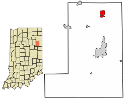
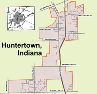
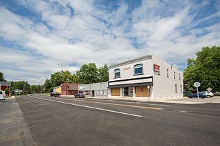
Huntertown is a town in Allen County, Indiana. The population was 9,141 at the time of the 2020 census, making it one of the fastest-growing areas in northeastern Indiana, with a population increase of 90 percent since 2010.

<span class="mw-page-title-main">Leo-Cedarville, Indiana</span> Town in Indiana, United States

Leo-Cedarville is a town in Cedar Creek Township, Allen County, Indiana, United States. The population was 3,603 at the 2010 census.

<span class="mw-page-title-main">Monroeville, Indiana</span> Town in Indiana, United States

Monroeville is a town in Monroe Township, Allen County, Indiana, United States. The population was 1,294 as of the 2020 census.

<span class="mw-page-title-main">Zanesville, Indiana</span> Town in Indiana, United States

Zanesville is a town in Wells and Allen counties in the U.S. state of Indiana, southwest of Fort Wayne. The population was 580 at the 2020 Census, down from 600 at the 2010 census.

<span class="mw-page-title-main">Waterloo, Indiana</span> Town in Indiana, United States

Waterloo is a town in Grant and Smithfield townships, DeKalb County, Indiana, United States. The population was 2,116 at the 2020 census.

<span class="mw-page-title-main">Chesterfield, Indiana</span> Town in Indiana, United States

Chesterfield is a town in the U.S. state of Indiana which lies in Union Township, Madison County, and Salem Township, Delaware County. The population was 2,490 at the 2020 census. It is part of the Indianapolis–Carmel–Anderson metropolitan statistical area.

<span class="mw-page-title-main">Upland, Indiana</span> Town in Indiana, United States

Upland is a town in Jefferson Township, Grant County, Indiana, United States. The population was 3,821 at the 2020 census. It is the home of Taylor University, a Christian college.

<span class="mw-page-title-main">Springport, Indiana</span> Town in Indiana, United States

Springport is a town in Prairie Township, Henry County, Indiana, United States. The population was 149 at the 2010 census.

<span class="mw-page-title-main">Roanoke, Indiana</span> Town in Indiana, United States

Roanoke is a town in Jackson Township, Huntington County, Indiana, United States. The population was 1,762 at the 2020 census. Roanoke is governed by a town council. Town offices include the clerk treasurer, utilities department, police department, and volunteer fire department. The town has a public elementary school. WOWO and WRNP have transmitter towers in Roanoke, along U.S. Highway 24. For many years, television station WPTA was licensed to Roanoke, though that station's studios and transmitter have always been located in nearby Fort Wayne.

<span class="mw-page-title-main">Wolcottville, Indiana</span> Town in Indiana, United States

Wolcottville is a town in Orange Township, Noble County and Johnson Township, LaGrange County in the U.S. state of Indiana. The population was 998 at the 2010 census.

<span class="mw-page-title-main">Hamlet, Indiana</span> Town in Starke County, Indiana, United States

Hamlet is a town in Davis and Oregon Townships, Starke County, in the U.S. state of Indiana. The population was 800 as of the 2010 census.

<span class="mw-page-title-main">Boston, Indiana</span> Town in Indiana, United States

Boston is a town in Boston Township, Wayne County, Indiana, United States. The population was 138 at the 2010 census.

<span class="mw-page-title-main">Dublin, Indiana</span> Town in Indiana, United States

Dublin is a town in Jackson Township, Wayne County, in the U.S. state of Indiana. The population was 679 at the 2020 census.

<span class="mw-page-title-main">Economy, Indiana</span> Town in Indiana, United States

Economy is a town in Perry Township, Wayne County, in the U.S. state of Indiana. The population was 173 at the 2021 census.

<span class="mw-page-title-main">Fountain City, Indiana</span> Town in Indiana, United States

Fountain City, formerly Newport, is a town in New Garden Township, Wayne County, in the U.S. state of Indiana. The population was 796 at the 2010 census.

<span class="mw-page-title-main">Greens Fork, Indiana</span> Town in Indiana, United States

Greens Fork is a town in Clay Township, Wayne County, in the U.S. state of Indiana. The population was 423 at the 2010 census.

<span class="mw-page-title-main">Mount Auburn, Indiana</span> Town in Indiana, United States

Mount Auburn is a town in Jackson Township, Wayne County, in the U.S. state of Indiana. The population was 117 at the 2010 census. The town is sandwiched between Dublin and Cambridge City.

<span class="mw-page-title-main">Whitewater, Indiana</span> Town in Indiana, United States

Whitewater is a town in Franklin Township, Wayne County, in the U.S. state of Indiana. The population was 83 at the 2010 census.

<span class="mw-page-title-main">Columbia City, Indiana</span> City in Indiana, United States

Columbia City is a city in Columbia Township, Whitley County, in the U.S. state of Indiana. The population was 9,892 at the 2020 Census, up from 8,750 at the 2010 Census, estimated to be 10,064 in 2023. The city is the county seat of Whitley County, and is the largest community therein. It is part of the Fort Wayne MSA.

<span class="mw-page-title-main">Rockwood, Michigan</span> City in Michigan, United States

Rockwood is a city in southeastern Wayne County in the U.S. state of Michigan. The population was 3,289 at the 2010 census.

References

  1. "2020 U.S. Gazetteer Files". United States Census Bureau. Retrieved March 16, 2022.
  2. 1 2 3 U.S. Geological Survey Geographic Names Information System: Ossian, Indiana
  3. 1 2 "U.S. Census website". United States Census Bureau . Retrieved January 31, 2008.
  4. "History". About Ossian. Town of Ossian.
  5. "Wells County". Jim Forte Postal History. Retrieved July 6, 2016.
  6. Mettler, Katie (June 10, 2016). "The heartbreaking reason a giant Minion stands watch in rural Indiana". Washington Post . Retrieved June 12, 2016.
  7. "Family Transforms 25-Foot Silo Into Enormous Minion". ABC News . June 10, 2016. Retrieved June 12, 2016.
  8. "G001 - Geographic Identifiers - 2010 Census Summary File 1". United States Census Bureau. Archived from the original on February 13, 2020. Retrieved July 17, 2015.
  9. "Census of Population and Housing". Census.gov. Retrieved June 4, 2015.
  10. "U.S. Census website". United States Census Bureau . Retrieved December 11, 2012.
  11. "Northern Wells Community Schools Home". nwcs.k12.in.us. Retrieved October 9, 2016.
  12. "Service facilities". Wells County Public Library. Retrieved March 15, 2018.