Butler, Indiana

Last updated

Butler, Indiana
DeKalb County Indiana Incorporated and Unincorporated areas Butler Highlighted 1809532.svg
Location of Butler in DeKalb County, Indiana.
Coordinates: 41°25′41″N84°52′35″W / 41.42806°N 84.87639°W / 41.42806; -84.87639
Country United States
State Indiana
County DeKalb
Government
   Mayor Mike Hartman (R)[ citation needed ]
Area
[1]
  Total1.97 sq mi (5.11 km2)
  Land1.97 sq mi (5.11 km2)
  Water0.00 sq mi (0.00 km2)
Elevation
[2]
869 ft (265 m)
Population
 (2020)
  Total2,635
  Density1,334.85/sq mi (515.28/km2)
Time zone UTC-5 (EST)
  Summer (DST) UTC-4 (EDT)
ZIP code
46721
Area code 260
FIPS code 18-09532 [3]
GNIS feature ID2393482 [2]
Website http://www.butler.in.us

Butler is a city in DeKalb County, Indiana, United States. The population was 2,684 at the 2010 census.

Contents

History

Butler was platted in 1856 when the railroad was extended to that point. [4] It was likely named for David Butler, a pioneer. [5] Butler was incorporated as a town in 1866, and as a city in 1903. [6]

On July 23, 1966, Butler was one of the end points of a record-setting speed run by a New York Central RDC-3, M-497 Black Beetle, modified with a pair of jet engines, as the rail line between it and Stryker, Ohio, was both straight and flat. The car reached a speed of 183.68 mph (295.6 km/h), an American rail speed record that still stands today.

The Downtown Butler Historic District was added to the National Register of Historic Places in 2001. [7]

Geography

According to the 2010 census, Butler has a total area of 2.09 square miles (5.41 km2), all land. [8]

Demographics

Historical population
CensusPop.Note
1880 1,056
1890 2,521138.7%
1900 2,063−18.2%
1910 1,818−11.9%
1920 1,745−4.0%
1930 1,643−5.8%
1940 1,7949.2%
1950 1,9146.7%
1960 2,17613.7%
1970 2,39410.0%
1980 2,5094.8%
1990 2,6013.7%
2000 2,7254.8%
2010 2,684−1.5%
2020 2,635−1.8%
U.S. Decennial Census [9]

2010 census

As of the census [3] of 2010, there were 2,684 people, 951 households, and 668 families living in the city. The population density was 1,284.2 inhabitants per square mile (495.8/km2). There were 1,089 housing units at an average density of 521.1 per square mile (201.2/km2). The racial makeup of the city was 94.9% White, 0.5% African American, 0.4% Native American, 0.2% Asian, 2.3% from other races, and 1.8% from two or more races. Hispanic or Latino of any race were 4.3% of the population.

There were 951 households, of which 43.0% had children under the age of 18 living with them, 44.8% were married couples living together, 15.7% had a female householder with no husband present, 9.8% had a male householder with no wife present, and 29.8% were non-families. 24.4% of all households were made up of individuals, and 7.8% had someone living alone who was 65 years of age or older. The average household size was 2.71 and the average family size was 3.17.

The median age in the city was 33.7 years. 29.3% of residents were under the age of 18; 8.9% were between the ages of 18 and 24; 27.1% were from 25 to 44; 22.7% were from 45 to 64; and 11.9% were 65 years of age or older. The gender makeup of the city was 49.9% male and 50.1% female.

2000 census

As of the census [3] of 2000, there were 2,725 people, 983 households, and 699 families living in the city. The population density was 1,523.6 inhabitants per square mile (588.3/km2). There were 1,075 housing units at an average density of 601.1 per square mile (232.1/km2). The racial makeup of the city was 97.69% White, 0.15% African American, 0.18% Native American, 0.11% Asian, 1.25% from other races, and 0.62% from two or more races. Hispanic or Latino of any race were 2.24% of the population.

There were 983 households, out of which 40.5% had children under the age of 18 living with them, 53.8% were married couples living together, 12.1% had a female householder with no husband present, and 28.8% were non-families. 23.6% of all households were made up of individuals, and 8.1% had someone living alone who was 65 years of age or older. The average household size was 2.68 and the average family size was 3.17.

In the city, the population was spread out, with 30.8% under the age of 18, 10.3% from 18 to 24, 30.5% from 25 to 44, 18.3% from 45 to 64, and 10.2% who were 65 years of age or older. The median age was 31 years. For every 100 females, there were 94.9 males. For every 100 females age 18 and over, there were 90.2 males.

The median income for a household in the city was $37,250, and the median income for a family was $42,188. Males had a median income of $32,361 versus $21,404 for females. The per capita income for the city was $15,040. About 5.5% of families and 9.7% of the population were below the poverty line, including 11.7% of those under age 18 and 14.1% of those age 65 or over.

Government

The view from downtown Butler, Indiana, looking north past the major intersection between U.S. Highway 6 and State Road 1. Butler Indiana crossroads.jpg
The view from downtown Butler, Indiana, looking north past the major intersection between U.S. Highway 6 and State Road 1.
A distinctive home along State Road 1 on the north side of Butler, Indiana Butler Indiana home.jpg
A distinctive home along State Road 1 on the north side of Butler, Indiana

The government consists of a mayor and a Common Council, often referred to as the city council. The mayor is elected in a citywide vote. The city council consists of five members, four of whom are elected from Butler's four individual districts. The remaining councilperson is elected at large. The city council is responsible for hearing and passing ordinances that become law; town meetings occur on the first and third Monday of each month at 7 PM. [10]

Local newspaper

Butler is served by the Butler Bulletin, published weekly by KPC Media. They acquired it in December 2005 from its founder Joe Shelton. Joe had been publishing the newspaper since 1976. Jeff Jones has been the editor of the bulletin since 1985. [11]

Education

The city of Butler lies in the school district of DeKalb County Eastern Community Schools. The local schools city residents attend are:

Public library

The city of Butler is served by the Butler Public Library. [12] The library completed an expansion and renovation project in August 2009, nearly doubling its size. The expansion included a new Children's Department and Story Time Room, a new community room, Teen Zone and Genealogy Room.

Notable people

Related Research Articles

<span class="mw-page-title-main">Shiloh, DeKalb County, Alabama</span> Town in Alabama, United States

Shiloh is a town in DeKalb County, Alabama, United States. It incorporated in 1962. At the 2020 census, the population was 321. Shiloh is located atop Sand Mountain.

<span class="mw-page-title-main">Altona, Indiana</span> Town in Indiana, United States

Altona is a town in Keyser Township, DeKalb County, Indiana, United States. The population was 197 at the 2010 census.

<span class="mw-page-title-main">Ashley, Indiana</span> Town in Indiana, United States

Ashley is a town in Indiana located on the border of Smithfield Township, DeKalb County and Steuben Township, Steuben County. The population was 983 at the 2010 census.

<span class="mw-page-title-main">Corunna, Indiana</span> Town in Indiana, United States

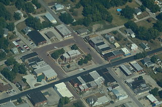
Corunna is a town in Richland Township, DeKalb County, Indiana, United States. The population was 236 at the 2020 census estimate.

<span class="mw-page-title-main">Saint Joe, Indiana</span> Place in Indiana, United States

Saint Joe is a town in Concord Township, DeKalb County, Indiana, United States. The population was 460 at the 2010 census.

<span class="mw-page-title-main">Waterloo, Indiana</span> Town in Indiana, United States

Waterloo is a town in Grant and Smithfield townships, DeKalb County, Indiana, United States. The population was 2,116 at the 2020 census.

<span class="mw-page-title-main">Markle, Indiana</span> Town in Indiana, United States

Markle is a town in Huntington and Wells counties, in the U.S. state of Indiana. The population was 1,071 at the 2020 census. It lies along Interstate 69, U.S. Route 224, State Road 116 and State Road 3.

<span class="mw-page-title-main">Wolcottville, Indiana</span> Town in Indiana, United States

Wolcottville is a town in Johnson Township, LaGrange County and Orange Township, Noble County in the U.S. state of Indiana. The population was 998 at the 2010 census.

<span class="mw-page-title-main">Westville, Indiana</span> Town in Indiana, United States

Westville is a town in New Durham Township, LaPorte County, Indiana, United States. The population, as of the 2020 census is 5257. It is included in the Michigan City, Indiana-La Porte, Indiana Metropolitan Statistical Area. Westville is located in Northwest Indiana, also known as The Region.

<span class="mw-page-title-main">Rising Sun, Indiana</span> City in Indiana, United States

Rising Sun is a city in Randolph Township and the county seat of Ohio County, Indiana, United States, along the Ohio River. It is also the only incorporated community in the county. The population of Rising Sun was 2,304 at the 2010 census.

<span class="mw-page-title-main">Vera Cruz, Indiana</span> Town in Indiana, United States

Vera Cruz is a town in Harrison Township, Wells County, in the U.S. state of Indiana. The population was 80 at the 2010 census.

<span class="mw-page-title-main">Latham, Kansas</span> City in Butler County, Kansas

Latham is a city in Butler County, Kansas, United States. As of the 2020 census, the population of the city was 96.

<span class="mw-page-title-main">Clarksdale, Missouri</span> City in Missouri, United States

Clarksdale is a city in southwest DeKalb County, Missouri, United States, located along the Little Third Fork of the Platte River. The population was 245 at the 2020 census. It is part of the St. Joseph, MO–KS Metropolitan Statistical Area.

<span class="mw-page-title-main">Maysville, Missouri</span> City in Missouri, United States

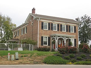
Maysville is a city in DeKalb County, Missouri, United States. The population was 1,095 at the 2020 census. Maysville is the county seat of DeKalb County.

<span class="mw-page-title-main">Octavia, Nebraska</span> Village in Nebraska, United States

Octavia is a village in Butler County, Nebraska, United States. The city had 127 residents as of 2010 census, according to the United States Census Bureau.

<span class="mw-page-title-main">Trenton, Ohio</span> City in Ohio, United States

Trenton is a city in northeastern Butler County, Ohio, United States, west of Middletown. The population was 13,021 at the 2020 census. It is part of the Cincinnati metropolitan area.

<span class="mw-page-title-main">Butler Township, Schuylkill County, Pennsylvania</span> Township in Pennsylvania, United States

Butler Township is a township in Schuylkill County, Pennsylvania, United States. Formed in 1848 from part of Barry Township, it is named for war hero William Orlando Butler.

<span class="mw-page-title-main">Osborn, Missouri</span> City in Missouri, United States

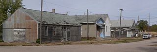
Osborn is a city in northern Clinton and southern DeKalb counties in the U.S. state of Missouri. The population was 374 at the 2020 census.

<span class="mw-page-title-main">DeKalb Township, DeKalb County, Illinois</span> Township in Illinois, United States

DeKalb Township is one of nineteen townships in DeKalb County, Illinois, USA. As of the 2020 census, its population was 42,667 and it contained 18,004 housing units. DeKalb Township was originally named Orange Township, but was renamed on November 20, 1850.

<span class="mw-page-title-main">Victor Township, DeKalb County, Illinois</span> Township in Illinois, United States

Victor Township is one of nineteen townships in DeKalb County, Illinois, USA. As of the 2020 census, its population was 275 and it contained 125 housing units. Victor Township was formed from Clinton Township around 1853.

References

  1. "2020 U.S. Gazetteer Files". United States Census Bureau. Retrieved March 16, 2022.
  2. 1 2 U.S. Geological Survey Geographic Names Information System: Butler, Indiana
  3. 1 2 3 "U.S. Census website". data.census.gov. United States Census Bureau . Retrieved January 22, 2023.
  4. History of DeKalb County, Indiana: Together with Sketches of Its Cities, Villages and Towns. Inter-State Publishing Company. 1885. pp.  962.
  5. Baker, Ronald L. (October 1995). From Needmore to Prosperity: Hoosier Place Names in Folklore and History . Indiana University Press. p.  83. ISBN   978-0-253-32866-3. ...the name probably honors David Butler, an early settler...
  6. History of Dekalb County, Indiana. B.F. Bowen & Co. 1914. pp.  148.
  7. "National Register Information System". National Register of Historic Places . National Park Service. July 9, 2010.
  8. "G001 - Geographic Identifiers - 2010 Census Summary File 1". United States Census Bureau. Archived from the original on February 13, 2020. Retrieved July 28, 2015.
  9. "Census of Population and Housing". Census.gov. Retrieved June 4, 2015.
  10. "Elected Officials". City of Butler, Indiana. Retrieved January 22, 2023.
  11. "About Us - KDC Media Group Inc" . Retrieved January 22, 2023. The Butler Bulletin, serving eastern DeKalb County, Ind., was purchased by KPC Media Group Inc. in December 2005, from publisher Joe Shelton, who founded the newspaper in 1976. The editor is Jeff Jones, who has worked for the weekly since 1985.
  12. "Indiana public library directory" (PDF). Indiana State Library . Retrieved January 22, 2023.