Markle, Indiana

Last updated
Markle, Indiana
Logan west of Lee, Markle.jpg
Logan Street residential area
Huntington County and Wells County Indiana Incorporated and Unincorporated areas Markle Highlighted 1847160.svg
Location of Markle in Huntington County and Wells County, Indiana.
Coordinates: 40°49′45″N85°20′28″W / 40.82917°N 85.34111°W / 40.82917; -85.34111
Country Flag of the United States (23px).png  United States
State Flag of Indiana.svg  Indiana
Counties Huntington, Wells
Township Rock Creek (Huntington County), Union (Huntington County), Rockcreek (Wells County), Union (Wells County)
Area
[1]
  Total1.43 sq mi (3.69 km2)
  Land1.37 sq mi (3.56 km2)
  Water0.05 sq mi (0.14 km2)
Elevation
[2]
807 ft (246 m)
Population
 (2020)
  Total1,071
  Density780.04/sq mi (301.16/km2)
Time zone UTC-5 (Eastern (EST))
  Summer (DST) UTC-4 (EDT)
ZIP code
46770
Area code 260
FIPS code 18-47160 [3]
GNIS feature ID2396736 [2]

Markle is a town in Huntington and Wells counties, in the U.S. state of Indiana. [2] The population was 1,071 at the 2020 census. It lies along Interstate 69, U.S. Route 224, State Road 116 and State Road 3.

Contents

History

Markle was laid out in 1836, but did not prosper until the railroad was extended to that point some time later. [4]

The Markle post office has been in operation since 1852. [5]

Geography

Markle is located at 40°49′35″N85°20′17″W / 40.82639°N 85.33806°W / 40.82639; -85.33806 (40.826477, -85.338076). [6] The Wabash River flows through the south edge of the town.

According to the 2010 census, Markle has a total area of 1.27 square miles (3.29 km2), of which 1.22 square miles (3.16 km2) (or 96.06%) is land and 0.05 square miles (0.13 km2) (or 3.94%) is water. [7]

Demographics

Historical population
CensusPop.Note
1880 220
1890 670204.5%
1900 7298.8%
1910 82012.5%
1920 717−12.6%
1930 621−13.4%
1940 6718.1%
1950 7339.2%
1960 7897.6%
1970 96322.1%
1980 9751.2%
1990 1,20823.9%
2000 1,102−8.8%
2010 1,095−0.6%
2020 1,071−2.2%
U.S. Decennial Census [8]

2010 census

As of the census [9] of 2010, there were 1,095 people, 433 households, and 282 families living in the town. The population density was 897.5 inhabitants per square mile (346.5/km2). There were 470 housing units at an average density of 385.2 per square mile (148.7/km2). The racial makeup of the town was 98.3% White, 0.8% African American, 0.2% Asian, 0.1% from other races, and 0.6% from two or more races. Hispanic or Latino of any race were 1.2% of the population.

There were 433 households, of which 29.8% had children under the age of 18 living with them, 52.7% were married couples living together, 9.0% had a female householder with no husband present, 3.5% had a male householder with no wife present, and 34.9% were non-families. 31.2% of all households were made up of individuals, and 12.3% had someone living alone who was 65 years of age or older. The average household size was 2.35 and the average family size was 2.94.

The median age in the town was 43 years. 23.1% of residents were under the age of 18; 6.9% were between the ages of 18 and 24; 22.3% were from 25 to 44; 27.7% were from 45 to 64; and 20.3% were 65 years of age or older. The gender makeup of the town was 47.9% male and 52.1% female.

2000 census

As of the census [3] of 2000, there were 1,102 people, 434 households, and 289 families living in the town. The population density was 1,116.3 inhabitants per square mile (431.0/km2). There were 471 housing units at an average density of 477.1 per square mile (184.2/km2). The racial makeup of the town was 99.27% White, 0.36% African American, and 0.36% from two or more races. Hispanic or Latino of any race were 0.64% of the population.

View of the intersection of State Road 3 and US 224 at Markle Markle Indiana.jpg
View of the intersection of State Road 3 and US 224 at Markle

There were 434 households, out of which 28.8% had children under the age of 18 living with them, 53.7% were married couples living together, 9.7% had a female householder with no husband present, and 33.4% were non-families. 28.6% of all households were made up of individuals, and 12.0% had someone living alone who was 65 years of age or older. The average household size was 2.42 and the average family size was 2.98.

In the town, the population was spread out, with 24.3% under the age of 18, 9.4% from 18 to 24, 27.4% from 25 to 44, 20.5% from 45 to 64, and 18.3% who were 65 years of age or older. The median age was 38 years. For every 100 females, there were 90.0 males. For every 100 females age 18 and over, there were 84.9 males.

The median income for a household in the town was $37,039, and the median income for a family was $48,654. Males had a median income of $35,163 versus $20,813 for females. The per capita income for the town was $18,504. About 3.6% of families and 6.7% of the population were below the poverty line, including 9.4% of those under age 18 and 3.1% of those age 65 or over.

Education

Markle residents may obtain a free library card from the Huntington City-Township Public Library in Downtown Huntington. [10]

Related Research Articles

<span class="mw-page-title-main">Vredenburgh, Alabama</span> Town in Alabama, United States

Vredenburgh is a town in Monroe County, Alabama, United States. It incorporated in 1912. At the 2020 census, the population was 222.

<span class="mw-page-title-main">Andrews, Indiana</span> Town in Indiana, United States

Andrews is a town in Dallas Township, Huntington County, Indiana, United States. The population was 1,048 at the 2020 census.

<span class="mw-page-title-main">Mount Etna, Indiana</span> Town in Indiana, United States

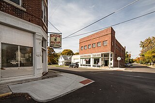
Mount Etna is a town in Huntington County, Indiana, United States. The population was 94 at the 2010 census. It lies at the intersection of four townships: Jefferson, Lancaster, Polk and Wayne.

<span class="mw-page-title-main">Roanoke, Indiana</span> Town in Indiana, United States

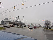
Roanoke is a town in Jackson Township, Huntington County, Indiana, United States. The population was 1,762 at the 2020 census. Roanoke is governed by a town council. Town offices include the clerk treasurer, utilities department, police department, and volunteer fire department. The town has a public elementary school. WOWO and WRNP have transmitter towers in Roanoke, along U.S. Highway 24. For many years, television station WPTA was licensed to Roanoke, though that station's studios and transmitter have always been located in nearby Fort Wayne.

<span class="mw-page-title-main">Warren, Indiana</span> Town in Indiana, United States

Warren is a town in Salamonie Township, Huntington County, Indiana. The population of Warren was 1,182 at the time of the 2020 census.

<span class="mw-page-title-main">Markleville, Indiana</span> Town in Indiana, United States

Markleville is a town in Adams Township, Madison County, Indiana, United States. It is part of the Indianapolis–Carmel–Anderson metropolitan statistical area. The population was 484 at the 2020 census.

Orrington is a town on the Penobscot River estuary in Penobscot County, Maine, United States. The population was 3,812 at the 2020 census.

<span class="mw-page-title-main">Hope Township, Midland County, Michigan</span> Civil township in Michigan, United States

Hope Township is a civil township of Midland County in the U.S. state of Michigan. The population was 1,373 at the 2020 census.

<span class="mw-page-title-main">Rock Springs, New Mexico</span> CDP in New Mexico, United States

Rock Springs is a census-designated place (CDP) in McKinley County, New Mexico, United States. The population was 558 at the 2000 census.

<span class="mw-page-title-main">Peralta, New Mexico</span> Town in New Mexico, United States

Peralta is a town in Valencia County, New Mexico, United States. Prior to its incorporation on July 1, 2007, it was a census-designated place (CDP). The population was 3,660 as of the 2010 census. Peralta is part of the Albuquerque metropolitan area.

<span class="mw-page-title-main">Jefferson Township, Butler County, Pennsylvania</span> Township in Pennsylvania, United States

Jefferson Township is a township in Butler County, Pennsylvania, United States. The population was 5,209 at the 2020 census.

<span class="mw-page-title-main">North Irwin, Pennsylvania</span> Borough in Pennsylvania, United States

North Irwin is a borough in Westmoreland County, Pennsylvania, United States. The population was 846 at the time of the 2010 census.

<span class="mw-page-title-main">Milton, West Virginia</span> Town in West Virginia, United States

Milton is a town in Cabell County, West Virginia, United States. The population was 2,831 at the 2020 census. It is part of the Huntington–Ashland metropolitan area.

<span class="mw-page-title-main">Hamlin, West Virginia</span> Town in West Virginia, United States

Hamlin is a town in and the county seat of Lincoln County, West Virginia, United States, along the Mud River. The population was recorded as 1,040 at the 2020 census. It is part of the Huntington–Ashland metropolitan area.

<span class="mw-page-title-main">West Hamlin, West Virginia</span> Town in West Virginia, United States

West Hamlin is a town in Lincoln County, West Virginia, United States, along the Guyandotte River. The population was 519 at the 2020 census, and is now down to 509, according to the 2021 census. West Hamlin is a part of the Huntington-Ashland, WV-KY-OH, Metropolitan Statistical Area (MSA). West Hamlin is west of the county seat at Hamlin, hence the name.

<span class="mw-page-title-main">Bancroft, West Virginia</span> Town in West Virginia, United States

Bancroft is a town in Putnam County, West Virginia, United States, along the Kanawha River. The population was 389 at the 2020 census. It is part of the Huntington–Ashland metropolitan area.

<span class="mw-page-title-main">Fort Gay, West Virginia</span> Town in West Virginia, United States

Fort Gay is a town in Wayne County, West Virginia, United States, situated along the Tug Fork and Big Sandy rivers. The town adjoins Louisa, Kentucky. The population was 677 at the 2020 census.

<span class="mw-page-title-main">Glen Haven, Wisconsin</span> Town in Wisconsin, United States

Glen Haven is a town in Grant County, Wisconsin, United States. According to the 2000 census, the town population was 490. The census-designated place of Glen Haven is located in the town.

<span class="mw-page-title-main">Chief Lake, Wisconsin</span> CDP in Wisconsin, United States

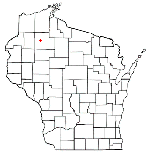
Chief Lake is a census-designated place (CDP) in the town of Hayward, Sawyer County, Wisconsin, United States. The population was 583 at the 2010 census.

<span class="mw-page-title-main">Little Round Lake, Wisconsin</span> CDP in Wisconsin, United States

Little Round Lake is a census-designated place (CDP) in the town of Bass Lake, Sawyer County, Wisconsin, United States. The population was 1,081 at the 2010 census. It is the largest community on the reservation of the federally recognized tribe of the Lac Courte Oreilles Band of Lake Superior Chippewa Indians.

References

  1. "2020 U.S. Gazetteer Files". United States Census Bureau. Retrieved March 16, 2022.
  2. 1 2 3 U.S. Geological Survey Geographic Names Information System: Markle, Indiana
  3. 1 2 "U.S. Census website". United States Census Bureau . Retrieved 2008-01-31.
  4. Bash, Frank Sumner (1914). History of Huntington County, Indiana: A Narrative Account of Its Historical Progress, Its People, and Its Principal Interests. The Lewis Publishing Company. pp.  160.
  5. "Huntington County". Jim Forte Postal History. Retrieved July 6, 2016.
  6. "US Gazetteer files: 2010, 2000, and 1990". United States Census Bureau. 2011-02-12. Retrieved 2011-04-23.
  7. "G001 - Geographic Identifiers - 2010 Census Summary File 1". United States Census Bureau. Archived from the original on 2020-02-13. Retrieved 2015-07-17.
  8. "Indiana's Census 2020 Redistricting Data Dashboard". Census.gov. Retrieved August 13, 2021.
  9. "U.S. Census website". United States Census Bureau . Retrieved 2012-12-11.
  10. "Getting your library card". Huntington City-Twp Public Library. Retrieved 8 March 2018.