Orland, Indiana

Last updated

Orland, Indiana
Steuben County Indiana Incorporated and Unincorporated areas Orland Highlighted 1857006.svg
Location of Orland in Steuben County, Indiana.
Coordinates: 41°43′50″N85°10′20″W / 41.73056°N 85.17222°W / 41.73056; -85.17222
Country United States
State Indiana
County Steuben
Township Millgrove
Area
[1]
  Total0.69 sq mi (1.78 km2)
  Land0.69 sq mi (1.78 km2)
  Water0.00 sq mi (0.00 km2)
Elevation
[2]
958 ft (292 m)
Population
 (2020)
  Total389
  Density567.06/sq mi (219.01/km2)
Time zone UTC-5 (Eastern (EST))
  Summer (DST) UTC-4 (EDT)
ZIP code
46776
Area code 260
FIPS code 18-57006 [3]
GNIS feature ID2396836 [2]
The Ernsberger House, formerly a stop on the Underground Railroad. Today, it is better known as the Parker House, once home to John G. Parker and his wife Elmira J. Parker, daughter of Michigan Governor Cyrus Gray Luce. Parker House, Orland, Indiana.jpg
The Ernsberger House, formerly a stop on the Underground Railroad. Today, it is better known as the Parker House, once home to John G. Parker and his wife Elmira J. Parker, daughter of Michigan Governor Cyrus Gray Luce.

Orland is a town located in the northwest corner of Steuben County, Indiana in Millgrove Township at the intersection of State Road 120 and State Road 327. The population was 434 at the 2010 census.

Contents

History

Orland is recognized as the first settlement in Steuben County, [5] populated by migrants from Vermont and originally known as Vermont Settlement. Each year in late July, Orland celebrates this heritage with the Vermont Settlement Festival. Orland was settled in 1834 after a Vermont man named John Stocker had gone prospecting for his family and the families of his neighbors. Stocker chose this particular piece of land because of the rich burr-oak openings he found. Pioneers coming from Windham County, Vermont, arrived shortly thereafter and built a Baptist church. [6] The town established a post office in 1837. [7]

In the decades leading up to the Civil War, Orland was a stop on the Underground Railroad, sheltering and protecting runaway slaves until they could complete the journey to Windsor, Upper Canada. The home of Russell Brown was said to contain a secret apartment on the second floor, complete with a separate stairway, in which 15 to 20 slaves might hide. S. U. Clark's hotel also was said to have a secret hiding place behind a basement cupboard, while the Butler family south of Orland "fed and sheltered scores of them and then took them on to other stations." [8]

At one time or another during the period leading up to the Civil War, Brown, Clark, Benjamin Waterhouse, and Captain Samuel Barry were arrested for violating the Fugitive Slave Act of 1850. [9] Both Waterhouse and Barry were convicted, with Barry serving one hour in jail and paying a $30 fine (although other sources put the fine at $1000). [10]

Fawn River State Fish Hatchery was listed on the National Register of Historic Places in 1997. [11]

During the 2019–20 coronavirus pandemic, confirmed cases of COVID-19 were reported on May 2, 2020, at a local meat processing plant run by Miller Poultry which resulted in sanitation of the plant and the implementation of safety measures such as temperature checks, social distancing & available personal protective equipment for workers. [12]

Geography

According to the 2010 census, Orland has a total area of 0.66 square miles (1.71 km2), all land. [13]

Demographics

Historical population
CensusPop.Note
1880 416
1920 322
1930 310−3.7%
1940 307−1.0%
1950 38625.7%
1960 4249.8%
1970 4577.8%
1980 424−7.2%
1990 361−14.9%
2000 341−5.5%
2010 43427.3%
2020 389−10.4%
U.S. Decennial Census [14]

2010 census

As of the census [15] of 2010, there were 434 people, 168 households, and 117 families living in the town. The population density was 657.6 inhabitants per square mile (253.9/km2). There were 190 housing units at an average density of 287.9 per square mile (111.2/km2). The racial makeup of the town was 96.3% White, 1.2% African American, 1.6% from other races, and 0.9% from two or more races. Hispanic or Latino of any race were 9.0% of the population.

There were 168 households, of which 31.5% had children under the age of 18 living with them, 53.0% were married couples living together, 10.7% had a female householder with no husband present, 6.0% had a male householder with no wife present, and 30.4% were non-families. 28.6% of all households were made up of individuals, and 14.3% had someone living alone who was 65 years of age or older. The average household size was 2.58 and the average family size was 3.16.

The median age in the town was 40.2 years. 24% of residents were under the age of 18; 9.2% were between the ages of 18 and 24; 21.4% were from 25 to 44; 29% were from 45 to 64; and 16.1% were 65 years of age or older. The gender makeup of the town was 50.0% male and 50.0% female.

2000 census

As of the census [3] of 2000, there were 341 people, 137 households, and 90 families living in the town. The population density was 512.8 inhabitants per square mile (198.0/km2). There were 153 housing units at an average density of 230.1 per square mile (88.8/km2). The racial makeup of the town was 98.83% White, 0.29% Native American, 0.29% Asian, 0.29% from other races, and 0.29% from two or more races. Hispanic or Latino of any race were 0.29% of the population.

Orland, Indiana from 1876 Atlas Orland, Indiana 1876.PNG
Orland, Indiana from 1876 Atlas

There were 137 households, out of which 34.3% had children under the age of 18 living with them, 49.6% were married couples living together, 12.4% had a female householder with no husband present, and 33.6% were non-families. 29.2% of all households were made up of individuals, and 13.9% had someone living alone who was 65 years of age or older. The average household size was 2.49 and the average family size was 3.10.

In the town, the population was spread out, with 27.6% under the age of 18, 8.2% from 18 to 24, 29.9% from 25 to 44, 19.9% from 45 to 64, and 14.4% who were 65 years of age or older. The median age was 36 years. For every 100 females, there were 100.6 males. For every 100 females age 18 and over, there were 93.0 males.

The median income for a household in the town was $38,542, and the median income for a family was $45,417. Males had a median income of $33,438 versus $20,893 for females. The per capita income for the town was $15,188. About 9.2% of families and 7.9% of the population were below the poverty line, including 11.4% of those under age 18 and 7.7% of those age 65 or over.

Education

The town has a lending library, the Joyce Public Library. [16]

Notable natives and former residents

Footnotes

  1. "2020 U.S. Gazetteer Files". United States Census Bureau. Retrieved March 16, 2022.
  2. 1 2 U.S. Geological Survey Geographic Names Information System: Orland, Indiana
  3. 1 2 "U.S. Census website". United States Census Bureau . Retrieved January 31, 2008.
  4. See Sauer and Indiana DNR.
  5. Taylor, et al., p. 26.
  6. The expansion of New England: the spread of New England settlement and institutions to the Mississippi River, 1620-1865 by Lois Kimball Mathews page 202
  7. "Steuben County". Jim Forte Postal History. Retrieved September 29, 2016.
  8. Butler.
  9. Indiana Department of Natural Resources, Division of Historic Preservation and Archaeology.
  10. Sauer.
  11. "National Register Information System". National Register of Historic Places . National Park Service. July 9, 2010.
  12. Duffy, Jamie (May 2, 2020). "Steuben meat plant reports positive tests". The Journal Gazette .
  13. "G001 - Geographic Identifiers - 2010 Census Summary File 1". United States Census Bureau. Archived from the original on February 13, 2020. Retrieved July 17, 2015.
  14. "Census of Population and Housing". Census.gov. Retrieved June 4, 2015.
  15. "U.S. Census website". United States Census Bureau . Retrieved December 11, 2012.
  16. "Indiana public library directory" (PDF). Indiana State Library. Archived from the original (PDF) on February 18, 2017. Retrieved March 15, 2018.

Related Research Articles

<span class="mw-page-title-main">Jamestown, Indiana</span> Town in Indiana, United States

Jamestown is a town in Jackson Township, Boone County and Eel River Township, Hendricks County, Indiana, United States. The population was 958 at the 2010 census.

<span class="mw-page-title-main">Ashley, Indiana</span> Town in Indiana, United States

Ashley is a town in Indiana located on the border of Smithfield Township, DeKalb County and Steuben Township, Steuben County. The population was 983 at the 2010 census.

<span class="mw-page-title-main">Hamilton, Indiana</span> Town in Indiana, United States

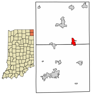
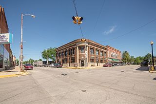
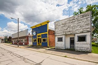
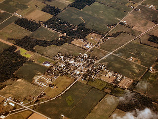
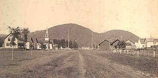
Hamilton is a town located on the border of Steuben County, Indiana and DeKalb County, Indiana. In Steuben County, it is in Otsego Township, and in DeKalb County it is in Franklin Township. The population was 1,532 at the 2010 census.

<span class="mw-page-title-main">Akron, Indiana</span> Town in Indiana, United States

Akron is a town in Henry Township, Fulton County, Indiana, United States. The population was 1,167 at the 2010 census.

<span class="mw-page-title-main">Sulphur Springs, Indiana</span> Town in Indiana, United States

Sulphur Springs is a town in Jefferson Township, Henry County, Indiana, United States. As of the 2010 census, the town's population was 399.

<span class="mw-page-title-main">Andrews, Indiana</span> Town in Indiana, United States

Andrews is a town in Dallas Township, Huntington County, Indiana, United States. The population was 1,048 at the 2020 census.

<span class="mw-page-title-main">Bryant, Indiana</span> Town in Indiana, United States

Bryant is a town in Bearcreek Township, Jay County, Indiana, United States. The population was 252 at the 2010 census.

<span class="mw-page-title-main">Sandborn, Indiana</span> Town in Indiana, United States

Sandborn is a town in Vigo Township, Knox County, Indiana, United States. The population was 359 at the 2020 census. It is the home of the annual Black Creek Festival.

<span class="mw-page-title-main">Claypool, Indiana</span> Town in Indiana, United States

Claypool is a town in Clay Township, Kosciusko County, in the U.S. state of Indiana. The population was 431 at the 2010 census.

<span class="mw-page-title-main">Leesburg, Indiana</span> Town in Indiana, United States

Leesburg is a town in Plain Township, Kosciusko County, in the U.S. state of Indiana. The population was 555 at the 2010 Census. The town of Leesburg was laid out in 1833 by Levi Lee. It includes the Leesburg Historic District.

<span class="mw-page-title-main">Macy, Indiana</span> Town in Indiana, United States

Macy is a town in Allen Township, Miami County, in the U.S. state of Indiana. The population was 199 at the 2020 census.

<span class="mw-page-title-main">Morristown, Indiana</span> Town in Indiana, United States

Morristown is a town in Hanover Township, Shelby County, in the U.S. state of Indiana. The population was 1,218 at the 2010 census.

<span class="mw-page-title-main">Clear Lake, Indiana</span> Town in Indiana, United States

Clear Lake is a town located in the northeast corner of Steuben County, Indiana, in Clear Lake Township. As such, is the northeasternmost community in the State of Indiana. The population was 339 at the 2010 census.

<span class="mw-page-title-main">Fremont, Indiana</span> Town in Indiana, United States

Fremont is a town in Fremont Township, Steuben County, in the U.S. state of Indiana. The population was 2,138 at the 2010 census.

<span class="mw-page-title-main">Hudson, Indiana</span> Town in Indiana, United States

Hudson is a town in Salem and Steuben townships, Steuben County, in the U.S. state of Indiana. The population was 518 at the 2010 census.

<span class="mw-page-title-main">Campbellsburg, Indiana</span> Town in Indiana, United States

Campbellsburg is a town in Brown Township, Washington County, in the U.S. state of Indiana. The population was 585 at the 2010 census.

<span class="mw-page-title-main">Fountain City, Indiana</span> Town in Indiana, United States

Fountain City, formerly Newport, is a town in New Garden Township, Wayne County, in the U.S. state of Indiana. The population was 796 at the 2010 census.

<span class="mw-page-title-main">Gilead, Maine</span> Town in the state of Maine, United States

Gilead is a town in Oxford County, Maine, United States. Upon incorporation in 1804, it was named for the large quantity of Balm of Gilead trees in the town center. The population was 195 at the 2020 census.

<span class="mw-page-title-main">Steuben, New York</span> Town in Oneida County, New York, US

Steuben is a town in Oneida County, New York, United States. The population was 1,110 at the 2010 census. The town is named after Baron von Steuben, a Prussian general who fought on the American side in the American Revolutionary War.

Wayland is a village in Steuben County, New York, United States. The population was 1,865 at the 2010 census.

References