Altona, Indiana

Last updated

Altona, Indiana
DeKalb County Indiana Incorporated and Unincorporated areas Altona Highlighted 1801288.svg
Location of Altona in DeKalb County, Indiana.
Coordinates: 41°21′08″N85°09′09″W / 41.35222°N 85.15250°W / 41.35222; -85.15250 [1]
Country United States
State Indiana
County DeKalb
Township Keyser
Area
[2]
  Total0.20 sq mi (0.53 km2)
  Land0.20 sq mi (0.53 km2)
  Water0.00 sq mi (0.00 km2)
Elevation
[1]
883 ft (269 m)
Population
 (2020)
  Total213
  Density1,049.26/sq mi (405.67/km2)
Time zone UTC−5 (EST)
  Summer (DST) UTC−5 (EST)
ZIP code
46738
Area code 260
FIPS code 18-01288
GNIS ID2397426 [1]

Altona is a town in Keyser Township, DeKalb County, Indiana, United States. The population was 197 at the 2010 census.

Contents

History

Incorporated in 1906. [3] A post office was established at Altona in 1874, and remained in operation until it was discontinued in 1913. [4]

Geography

Altona borders the larger city of Garrett.

According to the 2010 census, Altona has a total area of 0.22 square miles (0.57 km2), all land. [5]

Demographics

Historical population
CensusPop.Note
1880 100
1910 349
1920 3829.5%
1930 342−10.5%
1940 340−0.6%
1950 3441.2%
1960 313−9.0%
1970 269−14.1%
1980 263−2.2%
1990 156−40.7%
2000 19826.9%
2010 197−0.5%
2020 2138.1%
U.S. Decennial Census [6]

2010 census

As of the 2010 census, [7] there were 197 people, 90 households, and 45 families living in the town. The population density was 895.5 inhabitants per square mile (345.8/km2). There were 98 housing units at an average density of 445.5 per square mile (172.0/km2). The racial makeup of the town was 98.5% White, 0.5% Native American, and 1.0% from two or more races. Hispanic or Latino of any race were 1.0% of the population.

There were 90 households, of which 24.4% had children under the age of 18 living with them, 40.0% were married couples living together, 5.6% had a female householder with no husband present, 4.4% had a male householder with no wife present, and 50.0% were non-families. 46.7% of all households were made up of individuals, and 17.7% had someone living alone who was 65 years of age or older. The average household size was 2.19 and the average family size was 3.24.

The median age in the town was 41.1 years. 20.3% of residents were under the age of 18; 8.7% were between the ages of 18 and 24; 26.9% were from 25 to 44; 26.4% were from 45 to 64, and 17.8% were 65 years of age or older. The gender makeup of the town was 51.8% male and 48.2% female.

2000 census

As of the 2000 census, [8] there were 198 people, 89 households, and 50 families living in the town. The population density was 787.2 inhabitants per square mile (303.9/km2). There were 90 housing units at an average density of 357.8 per square mile (138.1/km2). The racial makeup of the town was 98.99% White, 0.51% African American, and 0.51% from two or more races. Hispanic or Latino of any race were 1.01% of the population.

There were 89 households, out of which 22.5% had children under the age of 18 living with them, 41.6% were married couples living together, 12.4% had a female householder with no husband present, and 43.8% were non-families. 39.3% of all households were made up of individuals, and 19.1% had someone living alone who was 65 years of age or older. The average household size was 2.22 and the average family size was 3.00.

In the town, the population was spread out, with 21.2% under the age of 18, 11.6% from 18 to 24, 25.8% from 25 to 44, 23.2% from 45 to 64, and 18.2% who were 65 years of age or older. The median age was 37 years. For every 100 females, there were 106.3 males. For every 100 females age 18 and over, there were 102.6 males.

The median income for a household in the town was $28,958, and the median income for a family was $36,042. Males had a median income of $25,833 versus $26,429 for females. The per capita income for the town was $18,530. About 9.4% of families and 12.1% of the population were below the poverty line, including 26.5% of those under the age of eighteen and 4.7% of those sixty-five or over.

Related Research Articles

<span class="mw-page-title-main">Hammond, Maine</span> Town in the state of Maine, United States

Hammond is a town in Aroostook County, Maine, United States. The population was 91 at the 2020 census.

<span class="mw-page-title-main">Hersey, Maine</span> Town in the state of Maine, United States

Hersey is a town in Aroostook County, Maine, United States. The population was 73 at the 2020 census.

<span class="mw-page-title-main">Merrill, Maine</span> Town in the state of Maine, United States

Merrill is a town in Aroostook County, Maine, United States. The population was 208 at the 2020 census.

<span class="mw-page-title-main">New Canada, Maine</span> Town in the state of Maine, United States

New Canada is a town in Aroostook County, Maine, United States. The population was 310 at the 2020 census.

<span class="mw-page-title-main">Perham, Maine</span> Town in the state of Maine, United States

Perham is a town in Aroostook County, Maine, United States. The population was 371 at the 2020 census. The town was named after Maine's 33rd governor, Sidney Perham.

<span class="mw-page-title-main">Sherman, Maine</span> Town in the state of Maine, United States

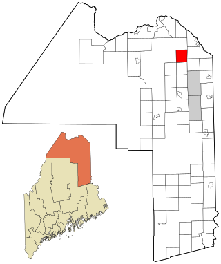
Sherman is a town in Aroostook County, Maine, United States. The population was 815 at the 2020 census.

<span class="mw-page-title-main">Stockholm, Maine</span> Town in the state of Maine, United States

Stockholm is a town in Aroostook County, Maine, United States. The population was 250 at the 2020 census.

<span class="mw-page-title-main">Westfield, Maine</span> Town in the state of Maine, United States

Westfield is a town in Aroostook County, Maine, United States. The population was 455 at the 2020 census.

<span class="mw-page-title-main">Chesterville, Maine</span> Town in Maine, United States

Chesterville is a town in Franklin County, Maine, United States. The population was 1,328 at the 2020 census.

Stoneham is a town in Oxford County, Maine, United States. The population was 261 at the 2020 census.

<span class="mw-page-title-main">Upton, Maine</span> Town in the state of Maine, United States

Upton is a town in Oxford County, Maine, United States. The population was 69 at the 2020 census.

Detroit is a town in Somerset County, Maine, United States. The population was 885 at the 2020 census.

Meddybemps is a town in Washington County, Maine, United States. The population was 139 at the 2020 census.

<span class="mw-page-title-main">Vergas, Minnesota</span> City in Minnesota, United States

Vergas is a city in northern Otter Tail County, Minnesota, United States. The population was 348 at the 2020 census.

<span class="mw-page-title-main">Worthington, West Virginia</span> Town in West Virginia, United States

Worthington is a town in Marion County, West Virginia, United States. The population was 158 at the 2010 census. Worthington was incorporated in 1893 and named for Colonel George Worthington, an early settler. U.S. Route 19 passes through the town.

<span class="mw-page-title-main">Newburg, West Virginia</span> Town in West Virginia, United States

Newburg is a town in western Preston County, West Virginia, United States. The population was 275 at the 2020 census. It is part of the Morgantown metropolitan area.

<span class="mw-page-title-main">Bancroft, West Virginia</span> Town in West Virginia, United States

Bancroft is a town in Putnam County, West Virginia, United States, along the Kanawha River. The population was 389 at the 2020 census. It is part of the Huntington–Ashland metropolitan area.

<span class="mw-page-title-main">Camden-on-Gauley, West Virginia</span> Town in West Virginia, United States

Camden-on-Gauley is a town in Webster County, West Virginia, United States, along the Gauley River. The population was 126 at the 2020 census.

<span class="mw-page-title-main">St. Albans, Maine</span> Town in the state of Maine, United States

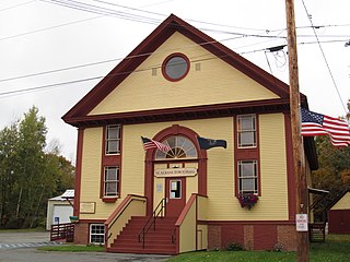
St. Albans is a town in Somerset County, Maine, United States. The population was 2,045 at the 2020 census.

<span class="mw-page-title-main">Altona (CDP), New York</span> Census-designated place in New York, United States

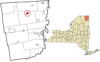
Altona is a hamlet and census-designated place (CDP) in the town of Altona, Clinton County, New York, United States. The population was 730 at the 2010 census, out of a total town population of 2,887.

References

  1. 1 2 3 U.S. Geological Survey Geographic Names Information System: Altona, Indiana
  2. "2020 U.S. Gazetteer Files". United States Census Bureau. Retrieved March 16, 2022.
  3. "Kendallville Standard - Google News Archive Search".
  4. "DeKalb County". Jim Forte Postal History. Retrieved September 3, 2014.
  5. "G001 - Geographic Identifiers - 2010 Census Summary File 1". United States Census Bureau. Archived from the original on February 13, 2020. Retrieved July 13, 2015.
  6. "Census of Population and Housing". Census.gov. Retrieved June 4, 2015.
  7. "U.S. Census website". United States Census Bureau . Retrieved December 11, 2012.
  8. "U.S. Census website". United States Census Bureau . Retrieved January 31, 2008.