Huntington, Indiana

Last updated

Huntington, Indiana
Huntington Indiana County Courthouse.JPG
Flag of Huntington, Indiana.png
Seal of Huntington, Indiana.png
Nickname: 
"The Lime City"
Huntington County Indiana Incorporated and Unincorporated areas Huntington Highlighted 1835302.svg
Location of Huntington in Huntington County, Indiana
Coordinates: 40°52′50″N85°30′23″W / 40.88056°N 85.50639°W / 40.88056; -85.50639
Country United States
State Indiana
County Huntington
Government
  Type Mayor-council government
   Mayor Richard Strick (I) [1]
Area
[2]
  Total9.45 sq mi (24.47 km2)
  Land9.31 sq mi (24.12 km2)
  Water0.14 sq mi (0.35 km2)
Elevation
[3]
791 ft (241 m)
Population
 (2020)
  Total17,022
  Density1,827.96/sq mi (705.81/km2)
Time zone UTC−5 (EST)
  Summer (DST) UTC−4 (EDT)
ZIP Code
46750
Area code 260
FIPS code 18-35302 [4]
GNIS feature ID2394452 [3]
Website www.huntington.in.us/city

Huntington, known as the "Lime City", is the largest city in and the county seat of Huntington County, Indiana, United States. [5] It is in Huntington and Union townships. It is also part of Fort Wayne, Indiana's metropolitan area. The population was 17,022 at the 2020 United States Census, down from 17,391 in the 2010 United States Census.

Contents

History

Name

Huntington was named by Capt. Elias Murray, a member of the legislature. The name Huntington is derived from Samuel Huntington, a judge, politician, and patriot in the American Revolution. Samuel Huntington is also known for being the 3rd Governor of Connecticut and the 7th President of the Continental Congress. Being a delegate to the Second Continental Congress, Huntington took part in voting for and signing the Declaration of Independence and the Articles of Confederation.

Early settlement

The county of Huntington was formally organized on December 2, 1834. The city of Huntington was first established by a group of pioneers, most notably Capt. Elias Murray. By 1849, Huntington contained 150 houses and a population of 700. [6]

Historical literature

The Lake Cities, stopped at Huntington, IN on December 21, 1969 Train 5, The Lake Cities, stopped at Huntington, IN on December 21, 1969. (24030137383).jpg
The Lake Cities, stopped at Huntington, IN on December 21, 1969

A small number of books have been published about the history of Huntington County, the first being History of Huntington County, Indiana originally published by Brant & Fuller. Two other books about Huntington include History of Huntington County, IN by Frank Sumner Bash in 1914 (describing its historical progress, its people, and its principal interests) and Huntington County, IN: Histories and Families by Turner Publishing Company in 1993 as a result of the Huntington County Historical Society officers and board of directors meeting in summer 1992 to discuss the family history of Huntington, the glue that has held together the city and county of Huntington in the heartland of the Midwest for more than 175 years.

Buildings that once sat along the Wabash and Erie Canal. Foreground was once a boat basin. Huntington Indiana Wabash n Erie Canal Brick Bldg.JPG
Buildings that once sat along the Wabash and Erie Canal. Foreground was once a boat basin.

Wabash and Erie canal

The Wabash and Erie Canal was constructed through Huntington County in 1834 and added major economic benefit to the area. In addition to the Wabash River cutting through Huntington (see Forks of the Wabash), this newly opened trade route accelerated the population and economic growth in Huntington.

Geography

Aerial view of Huntington looking northeast. Huntington-indiana-from-above.jpg
Aerial view of Huntington looking northeast.

Huntington is located on the Wabash River. According to the 2010 census, Huntington has a total area of 8.844 square miles (22.91 km2), of which 8.71 square miles (22.56 km2) (or 98.48%) is land and 0.134 square miles (0.35 km2) (or 1.52%) is water. [7]

Climate

Climate data for Huntington, Indiana (1991–2020 normals, extremes 1893–present)
MonthJanFebMarAprMayJunJulAugSepOctNovDecYear
Record high °F (°C)66
(19)
75
(24)
86
(30)
91
(33)
97
(36)
106
(41)
110
(43)
105
(41)
103
(39)
94
(34)
81
(27)
71
(22)
110
(43)
Mean maximum °F (°C)56.0
(13.3)
59.4
(15.2)
70.6
(21.4)
80.9
(27.2)
88.6
(31.4)
93.0
(33.9)
93.6
(34.2)
92.5
(33.6)
90.4
(32.4)
82.9
(28.3)
69.1
(20.6)
58.6
(14.8)
94.5
(34.7)
Mean daily maximum °F (°C)33.3
(0.7)
37.0
(2.8)
48.0
(8.9)
61.4
(16.3)
72.6
(22.6)
81.1
(27.3)
84.4
(29.1)
82.6
(28.1)
76.8
(24.9)
64.2
(17.9)
50.0
(10.0)
38.2
(3.4)
60.8
(16.0)
Daily mean °F (°C)25.2
(−3.8)
27.9
(−2.3)
37.4
(3.0)
49.3
(9.6)
60.4
(15.8)
69.7
(20.9)
73.0
(22.8)
71.1
(21.7)
64.2
(17.9)
52.3
(11.3)
40.5
(4.7)
30.4
(−0.9)
50.1
(10.1)
Mean daily minimum °F (°C)17.0
(−8.3)
18.7
(−7.4)
26.9
(−2.8)
37.1
(2.8)
48.2
(9.0)
58.3
(14.6)
61.7
(16.5)
59.6
(15.3)
51.6
(10.9)
40.3
(4.6)
31.0
(−0.6)
22.7
(−5.2)
39.4
(4.1)
Mean minimum °F (°C)−4.2
(−20.1)
0.0
(−17.8)
10.2
(−12.1)
22.8
(−5.1)
33.1
(0.6)
44.0
(6.7)
50.9
(10.5)
49.2
(9.6)
38.3
(3.5)
27.1
(−2.7)
16.9
(−8.4)
4.5
(−15.3)
−7.9
(−22.2)
Record low °F (°C)−28
(−33)
−18
(−28)
−11
(−24)
6
(−14)
24
(−4)
34
(1)
42
(6)
35
(2)
26
(−3)
15
(−9)
−5
(−21)
−24
(−31)
−28
(−33)
Average precipitation inches (mm)2.49
(63)
2.18
(55)
2.66
(68)
3.95
(100)
4.71
(120)
4.61
(117)
4.48
(114)
3.66
(93)
3.25
(83)
3.00
(76)
3.25
(83)
2.38
(60)
40.62
(1,032)
Average snowfall inches (cm)9.9
(25)
6.7
(17)
2.8
(7.1)
0.4
(1.0)
0.0
(0.0)
0.0
(0.0)
0.0
(0.0)
0.0
(0.0)
0.0
(0.0)
0.0
(0.0)
1.0
(2.5)
5.1
(13)
25.9
(66)
Average precipitation days (≥ 0.01 in)11.18.39.712.012.211.810.39.08.39.810.19.8122.4
Average snowy days (≥ 0.1 in)5.34.01.80.30.00.00.00.00.00.00.73.415.5
Source: NOAA [8] [9] [10]

Demographics

Historical population
CensusPop.Note
1850 594
1860 1,664180.1%
1870 2,92575.8%
1880 3,86332.1%
1890 7,32889.7%
1900 9,49129.5%
1910 10,2728.2%
1920 14,00036.3%
1930 13,420−4.1%
1940 13,9033.6%
1950 15,0798.5%
1960 16,1857.3%
1970 16,2170.2%
1980 16,202−0.1%
1990 16,3891.2%
2000 17,4506.5%
2010 17,391−0.3%
2020 17,022−2.1%
U.S. Decennial Census [11]

2010 census

As of the census [12] of 2010, there were 17,391 people, 6,566 households, and 4,197 families living in the city. The population density was 1,996.7 inhabitants per square mile (770.9/km2). There were 7,487 housing units at an average density of 859.6 per square mile (331.9/km2). The racial makeup of the city was 96.4% White, 0.6% African American, 0.4% Native American, 0.5% Asian, 0.6% from other races, and 1.4% from two or more races. Hispanic or Latino of any race were 2.4% of the population.

There were 6,566 households, of which 34.1% had children under the age of 18 living with them, 45.2% were married couples living together, 13.3% had a female householder with no husband present, 5.4% had a male householder with no wife present, and 36.1% were non-families. Of all households 30.4% were made up of individuals, and 12.5% had someone living alone who was 65 years of age or older. The average household size was 2.48 and the average family size was 3.06.

The median age in the city was 33.4 years. 24.8% of residents were under the age of 18; 13.5% were between the ages of 18 and 24; 25.5% were from 25 to 44; 22.5% were from 45 to 64; and 13.5% were 65 years of age or older. The gender makeup of the city was 47.7% male and 52.3% female.

2000 census

As of the census [4] of 2000, there were 17,450 people, 6,717 households, and 4,419 families living in the city. The population density was 2,091.0 inhabitants per square mile (807.3/km2). There were 7,262 housing units at an average density of 870.2 per square mile (336.0/km2). The main religion is Roman Catholic, with around 42% of the city attending masses. The racial makeup of the city was 97.83% White, 0.21% African American, 0.45% Native American, 0.45% Asian, 0.02% Pacific Islander, 0.30% from other races, and 0.73% from two or more races. Hispanic or Latino of any race were 1.12% of the population.

There were 6,717 households, out of which 33.5% had children under the age of 18 living with them, 48.9% were married couples living together, 12.4% had a female householder with no husband present, and 34.2% were non-families. Of all households 29.0% were made up of individuals, and 12.0% had someone living alone who was 65 years of age or older. The average household size was 2.46 and the average family size was 3.03.

In the city, the population was spread out, with 26.2% under the age of 18, 12.9% from 18 to 24, 28.2% from 25 to 44, 18.9% from 45 to 64, and 13.8% who were 65 years of age or older. The median age was 33 years. For every 100 females, there were 91.5 males. For every 100 females age 18 and over, there were 87.3 males.

The median income for a household in the city was $45,600, and the median income for a family was $56,454. Males had a median income of $35,830 versus $26,921 for females. The per capita income for the city was $21,242. About 5.2% of families and 7.1% of the population were below the poverty line, including 8.2% of those under age 18 and 6.4% of those age 65 or over.

Schools

The Huntington County Community School Corporation serves the city of Huntington and all of Huntington County. The corporation's lone high school, Huntington North High School, is located in Huntington. The two corporation middle schools, Crestview Middle School, Riverview Middle School, and three of the five elementary schools lie just outside the city limits. The elementary schools include Flint Springs, Horace Mann, Lincoln, Roanoke, and Salamonie. Private schools include Huntington Catholic School operated by the Roman Catholic Church.

The town has a lending library, the Huntington City-Township Public Library. [13]

Economy

Catholic publisher Our Sunday Visitor is based in Huntington.

Communications

Local radio stations

Transportation

Huntington Municipal Airport, a small airport for general aviation, lies southeast of the city.

Several highways serve the city:

Notable people

Sports

Politics

Other

Points of interest

Huntington County Courthouse Huntington County Courthouse in Huntington from the northwest.jpg
Huntington County Courthouse

Related Research Articles

<span class="mw-page-title-main">Wabash County, Indiana</span> County in Indiana, United States

Wabash County is a county located in the northern central part of the U.S. state of Indiana. As of 2020, the population was 30,976. The county seat is Wabash.

<span class="mw-page-title-main">Huntington County, Indiana</span> County in Indiana, United States

Huntington County is a county in the U.S. state of Indiana. According to the 2020 United States Census, the population was 36,662. The county seat is Huntington.

<span class="mw-page-title-main">New Haven, Illinois</span> Village in Illinois, United States

New Haven is a village in Gallatin County, Illinois, United States, along the Little Wabash River near its mouth at the Wabash River. The population was 399 at the 2020 United States Census, down from 433 at the 2010 United States Census.

<span class="mw-page-title-main">St. Francisville, Illinois</span> City in Illinois, United States

St. Francisville or Saint Francisville is a city in Lawrence County, Illinois, United States. The population was 697 at the 2010 census.

<span class="mw-page-title-main">Delphi, Indiana</span> City in Indiana, United States

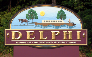
Delphi is a city in and the county seat of Carroll County, in the U.S. state of Indiana. Located twenty minutes northeast of Lafayette, it is part of the Lafayette, Indiana Metropolitan Statistical Area. The population was 2,893 at the 2010 census.

<span class="mw-page-title-main">Attica, Indiana</span> City in Indiana, United States

Attica is a city in Logan Township, Fountain County, Indiana, United States.

<span class="mw-page-title-main">Covington, Indiana</span> City in Indiana, United States

Covington is a city in, and the county seat of, Fountain County, Indiana, United States. The population was 2,645 at the 2010 census.

<span class="mw-page-title-main">Converse, Indiana</span> Town in Indiana, United States

Converse is a town in Jackson Township, Miami County, and Richland Township, Grant County, in the U.S. state of Indiana. The population was 1,161 at the 2020 census.

<span class="mw-page-title-main">Markle, Indiana</span> Town in Indiana, United States

Markle is a town in Huntington and Wells counties, in the U.S. state of Indiana. The population was 1,071 at the 2020 census. It lies along Interstate 69, U.S. Route 224, State Road 116 and State Road 3.

<span class="mw-page-title-main">Roanoke, Indiana</span> Town in Indiana, United States

Roanoke is a town in Jackson Township, Huntington County, Indiana, United States. The population was 1,762 at the 2020 census. Roanoke is governed by a town council. Town offices include the clerk treasurer, utilities department, police department, and volunteer fire department. The town has a public elementary school. WOWO and WRNP have transmitter towers in Roanoke, along U.S. Highway 24. For many years, television station WPTA was licensed to Roanoke, though that station's studios and transmitter have always been located in nearby Fort Wayne.

<span class="mw-page-title-main">Peru, Indiana</span> Town in Indiana

Peru is a city in, and the county seat of, Miami County, Indiana, United States. It is 73 miles (117 km) north of Indianapolis. The population was 11,073 at the 2020 census, making it the most populous community in Miami County. Peru is located along the Wabash River and is part of the Kokomo-Peru Combined Statistical Area.

<span class="mw-page-title-main">Alamo, Indiana</span> Town in Indiana, United States

Alamo is a town in Ripley Township, Montgomery County, in the U.S. state of Indiana. The population was 66 at the 2020 census, unchanged from 2010.

<span class="mw-page-title-main">Linden, Indiana</span> Town in Indiana, United States

Linden is a town in Madison Township, Montgomery County, in the U.S. state of Indiana. The population was 711 at the 2020 census.

<span class="mw-page-title-main">Mecca, Indiana</span> Town in Indiana, United States

Mecca is a town in Wabash Township, Parke County, in the U.S. state of Indiana. The population was 335 at the 2010 census.

<span class="mw-page-title-main">West Lafayette, Indiana</span> City in Indiana, United States

West Lafayette is a city in Tippecanoe County, Indiana, United States, approximately 65 miles (105 km) northwest of the state capital of Indianapolis and 113 miles (182 km) southeast of Chicago. West Lafayette is directly across the Wabash River from its sister city, Lafayette. As of the 2020 census, its population was 44,595. Home to Purdue University, it is a college town and the most densely populated city in Indiana.

<span class="mw-page-title-main">West Terre Haute, Indiana</span> Town in Indiana, United States

West Terre Haute is a town in Sugar Creek Township, Vigo County, Indiana, on the western side of the Wabash River near Terre Haute. The population was 2,236 at the 2010 census. It is part of the Terre Haute Metropolitan Statistical Area. Bethany Congregational Church was placed on the National Register of Historic Places in 2003.

<span class="mw-page-title-main">Lagro, Indiana</span> Town in Indiana, United States

Lagro is a town in Lagro Township, Wabash County, in the U.S. state of Indiana. The population was 415 at the 2010 census.

<span class="mw-page-title-main">Wabash, Indiana</span> City in Indiana, United States

Wabash is a city in Noble Township, Wabash County, in the U.S. state of Indiana. The population was 10,666 at the 2010 census. The city is situated along the Wabash River in the county seat of Wabash County.

<span class="mw-page-title-main">Bluffton, Indiana</span> City in Indiana, United States

Bluffton is a city in and the county seat of Wells County, Indiana, United States. The population was 10,308 at the 2020 census, up from 9,897 at the 2010 census. Bluffton is nicknamed the "Parlor City" for its history of having some of the first clean paved streets in the area during the time of the Indiana gas boom.

<span class="mw-page-title-main">Milton, West Virginia</span> Town in West Virginia, United States

Milton is a town in Cabell County, West Virginia, United States. The population was 2,831 at the 2020 census. It is part of the Huntington–Ashland metropolitan area.

References

  1. "Mayor's Office".
  2. "2020 U.S. Gazetteer Files". United States Census Bureau. Retrieved March 16, 2022.
  3. 1 2 U.S. Geological Survey Geographic Names Information System: Huntington, Indiana
  4. 1 2 "U.S. Census website". United States Census Bureau . Retrieved January 31, 2008.
  5. "Find a County". National Association of Counties. Archived from the original on May 31, 2011. Retrieved June 7, 2011.
  6. Branson, Ronald. "Huntington County". Crossroads of America: Early Indiana History HUNTINGTON COUNTY. Indiana County History Preservation Society. Archived from the original on May 12, 2012. Retrieved December 5, 2011.
  7. "G001 - Geographic Identifiers - 2010 Census Summary File 1". United States Census Bureau. Archived from the original on February 13, 2020. Retrieved July 28, 2015.
  8. "NOWData – NOAA Online Weather Data". National Oceanic and Atmospheric Administration. Retrieved November 17, 2023.
  9. "Summary of Monthly Normals 1991–2020". National Oceanic and Atmospheric Administration. Retrieved November 17, 2023.
  10. "xmACIS2". National Oceanic and Atmospheric Administration. Retrieved November 19, 2023.
  11. "Indiana's Census 2020 Redistricting Data Dashboard". Census.gov. Retrieved August 13, 2021.
  12. "U.S. Census website". United States Census Bureau . Retrieved December 11, 2012.
  13. "Indiana public library directory" (PDF). Indiana State Library. Retrieved March 7, 2018.
  14. "The Lauren Johnson Story: From Over 2:20 For 800 In HS To The U.S. World Championships Team At 1,500". LetsRun.com. August 17, 2015. Retrieved April 29, 2019.
  15. Vint, Bill (December 17, 2015). "Memphis' Gary Faulkner Jr. Wins First Title in Rolltech PBA World Championship" . Retrieved December 10, 2016.

Further reading