Rushville, Indiana Rville | |
---|---|
City of Rushville | |
Motto: Leading the Way in Rural Indiana | |
Coordinates: 39°37′32″N85°26′45″W / 39.62556°N 85.44583°W | |
Country | United States |
State | Indiana |
County | Rush |
Township | Rushville |
Government | |
• Mayor | Mike Pavey (R)[ citation needed ] |
Area | |
• Total | 3.31 sq mi (8.56 km2) |
• Land | 3.31 sq mi (8.56 km2) |
• Water | 0.00 sq mi (0.00 km2) 0% |
Elevation | 981 ft (299 m) |
Population (2020) | |
• Total | 6,208 |
• Density | 1,877.80/sq mi (725.04/km2) |
Time zone | UTC-5 (EST) |
• Summer (DST) | UTC-4 (EDT) |
ZIP code | 46173 |
Area code | 765 |
FIPS code | 18-66438 [3] |
GNIS feature ID | 2396452 [2] |
Website | http://www.cityofrushville.in.gov/ |
Rushville is a city in Rushville Township, Rush County, in the U.S. state of Indiana. [2] The population was 6,185 at the 2020 census. The city is the county seat of Rush County. [4] It, like the county, was named in honor of Dr. Benjamin Rush, who signed the Declaration of Independence. [5]
Rush County was formed from the unorganized Delaware County April 1, 1822. On July 29 town lots were sold and the town started to form. A school had already been started in 1821 by Dr. W.B. Laughlin, who was a member of the Legislature when the county was formed, and is considered the founding father of the town. A jail was built, Charles Veeder, was the first postmaster in 1822, and a courthouse was built in 1823. The Dog Fennel Gazette was published in 1823. The railroad was built in 1850 and after that a bank, factories, mills, and grain elevators sprang up. [6]
The Rushville post office has been in operation since 1822. [7]
Rushville was the campaign headquarters for Wendell Willkie's 1940 presidential campaign against Franklin Delano Roosevelt. Willkie is buried in the city's East Hill Cemetery.
The Durbin Hotel, John K. Gowdy House, Melodeon Hall, Rush County Courthouse, Rushville Commercial Historic District, St. Paul Methodist Episcopal Church, St. Prendergast Catholic church, [6] Booker T. Washington School, and Wendell Lewis Willkie House are listed on the National Register of Historic Places. [8]
Rushville is located along the Flatrock River. [9]
According to the 2010 census, Rushville has a total area of 3.09 square miles (8.00 km2), all land. [10]
Census | Pop. | Note | %± |
---|---|---|---|
1850 | 742 | — | |
1860 | 972 | 31.0% | |
1870 | 1,696 | 74.5% | |
1880 | 2,515 | 48.3% | |
1890 | 3,475 | 38.2% | |
1900 | 4,541 | 30.7% | |
1910 | 4,925 | 8.5% | |
1920 | 5,498 | 11.6% | |
1930 | 5,709 | 3.8% | |
1940 | 5,960 | 4.4% | |
1950 | 6,761 | 13.4% | |
1960 | 7,264 | 7.4% | |
1970 | 6,686 | −8.0% | |
1980 | 6,113 | −8.6% | |
1990 | 5,533 | −9.5% | |
2000 | 5,995 | 8.3% | |
2010 | 6,341 | 5.8% | |
2020 | 6,208 | −2.1% | |
U.S. Decennial Census [11] |
As of the census [3] of 2020, there were 6185 people, 2527 households, and 1,552 families residing in the city. The population density was 2,668.8 inhabitants per square mile (1,030.4/km2). There were 2,597 housing units at an average density of 1,156.1 per square mile (446.4/km2). The racial makeup of the city was 94.5% White, 1.5% Black, 0.20% Indian , 0.85% Asian, 0.05% Pacific Islander, 0.13% from other races, and 3.8% from two or more races. Hispanic or Latino of any race were 2.4% of the population.
There were 2,434 households, out of which 31.2% had children under the age of 18 living with them, 46.9% were married couples living together, 12.7% had a female householder with no husband present, and 36.2% were non-families. 31.6% of all households were made up of individuals, and 15.2% had someone living alone who was 65 years of age or older. The average household size was 2.39 and the average family size was 2.99.
In the city, the population was spread out, with 25.2% under the age of 18, 8.6% from 18 to 24, 28.6% from 25 to 44, 20.2% from 45 to 64, and 17.5% who were 65 years of age or older. The median age was 37 years. For every 100 females, there were 89.0 males. For every 100 females age 18 and over, there were 85.0 males.
The median income for a household in the city was $30,233, and the median income for a family was $36,646. Males had a median income of $30,127 versus $22,440 for females. The per capita income for the city was $17,072. About 8.1% of families and 11.0% of the population were below the poverty line, including 12.3% of those under age 18 and 12.0% of those age 65 or over.
The town has a lending library, the Rushville Public Library. [12]
Fairfield County is a county located in the U.S. state of Ohio. As of the 2020 census, the population was 158,921. Its county seat and largest city is Lancaster. Its name is a reference to the Fairfield area of the original Lancaster.
Champaign County is a county located in the U.S. state of Ohio. As of the 2020 census, the population was 38,714. Its county seat and largest city is Urbana. The county takes its name from the French word for "open level country". Champaign County became the 18th of 88 Ohio counties on March 1, 1805. It was formed from parts of Greene and Franklin counties by legislative action.
Mills County is a county located in the U.S. state of Iowa. As of the 2020 census, the population was 14,484. The county seat is Glenwood. The county was formed in 1851 and named for Major Frederick Mills of Burlington, Iowa who was killed at the Battle of Churubusco during the Mexican–American War.
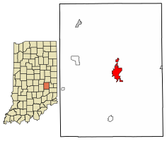
Rush County is a county in the U.S. state of Indiana. In the 2020 United States Census, the population was 16,752. The county seat is Rushville.
Henry County is a county located in east central Indiana, United States. As of 2020, the population was 48,914. The county seat and largest and only city is New Castle. Henry County is the main setting of the novel Raintree County by Ross Lockridge Jr.
Schuyler County is a county in the U.S. state of Illinois. According to the 2020 census, it had a population of 6,902. Its county seat is Rushville.
Mason County is a county in the U.S. state of Illinois. According to the 2020 census, it had a population of 13,086. Its county seat is Havana. The county is named in honor of George Mason, a member of the Virginia legislature who campaigned for the adoption of the United States Bill of Rights.
Lawrence County is the easternmost county in the U.S. state of Illinois. At the 2020 census, the population was 15,280. Its county seat is Lawrenceville.
Hamilton County is a county located in the U.S. state of Illinois. At the 2020 census, its population was 7,993. Its county seat is McLeansboro. It is located in the southern portion of the state known locally as "Little Egypt".
Fayette County is a county located in the U.S. state of Illinois. As of the 2020 census, the population was 21,488. Its county seat is Vandalia, the site of the Vandalia State House State Historic Site. Ramsey Lake State Recreation Area is located in the northwest part of this county.
Effingham County is located in the south central part of the U.S. state Illinois. As of the 2020 census, the population was 34,668. Its county seat and largest city is Effingham. Some other cities in Effingham County, Illinois include Altamont, Teutopolis, Beecher City, Montrose, Dieterich, Shumway, Watson, Mason, and Edgewood. Effingham County comprises the Effingham, IL Micropolitan Statistical Area.
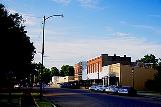
Rushville is a city in Schuyler County, Illinois, United States. The population was 3,005 at the 2020 census. It is the county seat of Schuyler County. It was first settled by Euro-Americans in 1823.
Warren is a town in Salamonie Township, Huntington County, Indiana. The population of Warren was 1,182 at the time of the 2020 census.
Elwood is a city in Madison and Tipton counties in the U.S. state of Indiana. The Madison County portion, which is nearly all of the city, is part of the Indianapolis–Carmel–Anderson metropolitan statistical area. The population of Elwood was 8,410 at the 2020 census.
Martinsville is a city in Washington Township, Morgan County, in the U.S. state of Indiana. The population was 12,309 at the 2020 United States Census. The city is the county seat of Morgan County.
Hayti is a city in eastern Pemiscot County, Missouri, United States. The population was 2,493 at the 2020 census.
Rushville is a city in Sheridan County, Nebraska, United States, in the remote Sandhills Region. Its population was 890 at the 2010 census. It is the county seat of Sheridan County.
Gorham is a town in Ontario County, New York, United States. The population was 4,130 at the 2020 census. The town is named after Nathaniel Gorham.
West Rushville is a village in Fairfield County, Ohio, United States. The population was 166 at the 2020 census.
Weston is a city in Lewis County, West Virginia, United States. The population was 3,943 at the 2020 census. It is the county seat of Lewis County, and home to the Museum of American Glass in West Virginia and the Trans-Allegheny Lunatic Asylum.