Tell City, Indiana

Last updated

Tell City, Indiana
City of Tell City
Tell City, Indiana Town Hall.jpg
A statue of William Tell and his son sits upon a fountain outside city hall. It is a famous city landmark.
Perry County Indiana Incorporated and Unincorporated areas Tell City Highlighted 1875248.svg
Location of Tell City in Perry County, Indiana.
Coordinates: 37°57′11″N86°45′21″W / 37.95306°N 86.75583°W / 37.95306; -86.75583
Country United States
State Indiana
County Perry
Township Troy
AcquiredJuly 1857
FoundedAugust 1858
Government
   Mayor Chris Cail (D)[ citation needed ]
Area
[1]
  Total4.65 sq mi (12.04 km2)
  Land4.53 sq mi (11.74 km2)
  Water0.12 sq mi (0.30 km2)  2.37%
Elevation
[2]
417 ft (127 m)
Population
 (2020)
  Total7,506
  Density1,655.49/sq mi (639.22/km2)
Time zone UTC-6 (CST)
  Summer (DST) UTC-5 (CDT)
ZIP code
47586
Area code 812
FIPS code 18-75248 [3]
GNIS feature ID2396037 [2]
Website tellcity.in.gov

Tell City is a city in Troy Township, Perry County, in the U.S. state of Indiana. It is located along the Ohio River. [4] The population was 7,506 at the 2020 census. The city is the county seat of Perry County.

Contents

History

Tell City traces its 150+ year old roots to a meeting in Cincinnati, Ohio in November 1856. A group of Swiss-German immigrants met in Cincinnati to organize a society known as the "Swiss Colonization Society." The society's purpose was to obtain affordable homesteads for mechanics, shopkeepers, factory workers, and small farmers in a location where all could live in harmony.

The Society decided to purchase a tract of land three miles (5 km) square to be surveyed as a city plot. The group was sent out to purchase the land and told to keep in mind they should find a healthful climate, fertile soil, good water, ample timber, as well as a location near a navigable river and a railroad, if possible. Purchase of a suitable site was made in July 1857. The tract, containing 4,152 acres (16.80 km2), was laid out in 392 town blocks with 7,328 building lots and 294 garden lots.

Tell City water tower Tell City Watertower.jpg
Tell City water tower

Before the settlers arrived, a name for the new town was selected. Initially called Helvetia, it was soon renamed Tell City, a name easier to pronounce and remember for English-speaking people. It was named for the legendary Swiss hero and liberator, William Tell. [5]

Indicative of the foresightedness of Tell City's founders are the wide streets. They are named for great persons of the military, arts, letters and science: DeKalb, Watt, Winkelreid, Steuben, Payne, Herrman, Reubens, Lafayette, Schiller, Tell, Fulton, Jefferson, Mozart, Franklin, Humboldt, Pestalozzi, Washington, Blum and Gutenberg.

The Tell City post office has been in operation since 1858. [6]

With 100 years of recorded history, the citizens of Tell City held a centennial celebration August 10–17, 1958 in honor of the early settlers and the founding of Tell City. After the success of the Centennial, the Tell City Historical Society decided they would sponsor a festival in 1959 to determine if the community would support it as an annual event. The festival, named Schweizer Fest (Swiss Fest), was a great success. Today, the festival remains one of Indiana's longest-running community festivals.

On March 17, 1960, Northwest Orient Airlines Flight 710, a Lockheed Electra turboprop airliner flying from Chicago to Miami lost a wing due to aerodynamic flutter and crashed in southern Indiana near Tell City. All 63 on board, including the crew, perished. The victims were impacted in a 30-foot-deep (9.1 m) crater, which became their final resting place. A monument with the names of the victims and the date of the tragedy marks the grave.

Steamboat 'Tell City'

The steamboat 'TELL CITY' was built in 1889 and named after Tell City. It was used to carry passengers and freight on the Ohio River until it sank on April 6, 1917 in Little Hocking, Ohio. The pilothouse survived the sinking and is the oldest remaining steamboat pilothouse, located at the Ohio River Museum in Marietta, Ohio. [7]

Education

Tell City is home to the Tell City High School Marksmen. The school is in Class 2A for football, basketball, and baseball.

Tell City has a public library, a branch of the Perry County Public Library. [8]

Geography

According to the 2010 census, Tell City has a total area of 4.635 square miles (12.00 km2), of which 4.53 square miles (11.73 km2) (or 97.73%) is land and 0.105 square miles (0.27 km2) (or 2.27%) is water. [9]

Climate

Climate data for Tell City, Indiana (1991–2020 normals, extremes 1939–present)
MonthJanFebMarAprMayJunJulAugSepOctNovDecYear
Record high °F (°C)79
(26)
77
(25)
88
(31)
91
(33)
96
(36)
105
(41)
105
(41)
104
(40)
106
(41)
96
(36)
86
(30)
80
(27)
106
(41)
Mean maximum °F (°C)63.3
(17.4)
67.8
(19.9)
74.9
(23.8)
82.1
(27.8)
87.5
(30.8)
92.5
(33.6)
94.1
(34.5)
94.0
(34.4)
92.0
(33.3)
84.7
(29.3)
74.0
(23.3)
56.1
(13.4)
95.8
(35.4)
Mean daily maximum °F (°C)40.5
(4.7)
44.7
(7.1)
54.2
(12.3)
65.7
(18.7)
74.4
(23.6)
82.2
(27.9)
85.3
(29.6)
84.7
(29.3)
79.2
(26.2)
68.1
(20.1)
54.9
(12.7)
44.4
(6.9)
64.9
(18.3)
Daily mean °F (°C)33.1
(0.6)
36.5
(2.5)
44.9
(7.2)
55.3
(12.9)
64.6
(18.1)
72.9
(22.7)
76.3
(24.6)
75.2
(24.0)
68.8
(20.4)
57.6
(14.2)
46.0
(7.8)
37.3
(2.9)
55.7
(13.2)
Mean daily minimum °F (°C)25.8
(−3.4)
28.2
(−2.1)
35.5
(1.9)
44.9
(7.2)
54.9
(12.7)
63.6
(17.6)
67.3
(19.6)
65.7
(18.7)
58.4
(14.7)
47.0
(8.3)
37.1
(2.8)
30.1
(−1.1)
46.5
(8.1)
Mean minimum °F (°C)9.2
(−12.7)
12.7
(−10.7)
21.5
(−5.8)
31.8
(−0.1)
41.8
(5.4)
53.3
(11.8)
59.8
(15.4)
58.0
(14.4)
46.2
(7.9)
34.3
(1.3)
24.7
(−4.1)
15.9
(−8.9)
6.4
(−14.2)
Record low °F (°C)−17
(−27)
−8
(−22)
−1
(−18)
20
(−7)
30
(−1)
42
(6)
47
(8)
46
(8)
31
(−1)
21
(−6)
0
(−18)
−14
(−26)
−17
(−27)
Average precipitation inches (mm)3.70
(94)
3.49
(89)
4.74
(120)
5.30
(135)
5.82
(148)
5.05
(128)
4.12
(105)
3.01
(76)
3.71
(94)
3.93
(100)
3.93
(100)
4.48
(114)
51.28
(1,303)
Average precipitation days (≥ 0.01 in)9.28.310.210.611.49.38.57.16.97.48.210.6107.7
Source: NOAA [10] [11]

Demographics

Historical population
CensusPop.Note
1860 1,030
1870 1,66061.2%
1880 2,11227.2%
1890 2,094−0.9%
1900 2,68028.0%
1910 3,36925.7%
1920 4,08621.3%
1930 4,87319.3%
1940 5,39510.7%
1950 5,7356.3%
1960 6,60915.2%
1970 7,93320.0%
1980 8,7049.7%
1990 8,088−7.1%
2000 7,845−3.0%
2010 7,272−7.3%
2020 7,5063.2%
U.S. Decennial Census [12]

2010 census

As of the census [13] of 2010, there were 7,272 people, 3,224 households, and 1,971 families residing in the city. The population density was 1,605.3 inhabitants per square mile (619.8/km2). There were 3,574 housing units at an average density of 789.0 per square mile (304.6/km2). The racial makeup of the city was 97.5% White, 0.3% African American, 0.3% Native American, 0.7% Asian, 0.3% from other races, and 0.9% from two or more races. Hispanic or Latino of any race were 1.0% of the population.

There were 3,224 households, of which 28.4% had children under the age of 18 living with them, 44.9% were married couples living together, 11.4% had a female householder with no husband present, 4.8% had a male householder with no wife present, and 38.9% were non-families. 34.3% of all households were made up of individuals, and 16.5% had someone living alone who was 65 years of age or older. The average household size was 2.23 and the average family size was 2.84.

The median age in the city was 42 years. 22% of residents were under the age of 18; 7.6% were between the ages of 18 and 24; 24.1% were from 25 to 44; 27% were from 45 to 64; and 19.3% were 65 years of age or older. The gender makeup of the city was 47.5% male and 52.5% female.

2000 census

As of the census [3] of 2000, there were 7,845 people, 3,404 households, and 2,161 families residing in the city. The population density was 1,721.4 inhabitants per square mile (664.6/km2). There were 3,700 housing units at an average density of 811.9 per square mile (313.5/km2). The racial makeup of the city was 98.65% White, 0.27% African American, 0.18% Native American, 0.23% Asian, 0.04% Pacific Islander, 0.14% from other races, and 0.50% from two or more races. Hispanic or Latino of any race were 0.89% of the population.

There were 3,404 households, out of which 26.4% had children under the age of 18 living with them, 49.3% were married couples living together, 10.7% had a female householder with no husband present, and 36.5% were non-families. 33.3% of all households were made up of individuals, and 17.2% had someone living alone who was 65 years of age or older. The average household size was 2.25 and the average family size was 2.85.

In the city, the population was spread out, with 21.9% under the age of 18, 9.2% from 18 to 24, 25.4% from 25 to 44, 22.7% from 45 to 64, and 20.8% who were 65 years of age or older. The median age was 41 years. For every 100 females, there were 89.5 males. For every 100 females age 18 and over, there were 84.6 males.

The median income for a household in the city was $31,045, and the median income for a family was $41,300. Males had a median income of $31,908 versus $21,232 for females. The per capita income for the city was $17,443. About 8.0% of families and 11.2% of the population were below the poverty line, including 15.7% of those under age 18 and 8.8% of those age 65 or over.

Notable people

See also

Related Research Articles

<span class="mw-page-title-main">Perry County, Ohio</span> County in Ohio, United States

Perry County is a county located in the U.S. state of Ohio. As of the 2020 census, the population was 35,408. Its county seat is New Lexington. It was established on March 1, 1818, from parts of Fairfield, Washington and Muskingum counties. The county is named for Oliver Hazard Perry, a hero of the War of 1812. Perry County is included in the Columbus, OH Metropolitan Statistical Area. One of the poorest counties in the state, this is where the lawsuit challenging Ohio's school funding system, DeRolph v. State, began.

<span class="mw-page-title-main">Hancock County, Kentucky</span> County in Kentucky, United States

Hancock County is a county located in the U.S. state of Kentucky. As of the 2020 census, the population was 9,095. Its county seat is in the city of Hawesville located in the Northern part of the county, and its largest city of Lewisport is located in the Northwestern part of the county.

<span class="mw-page-title-main">Washington, Indiana</span> City in Daviess County, Indiana

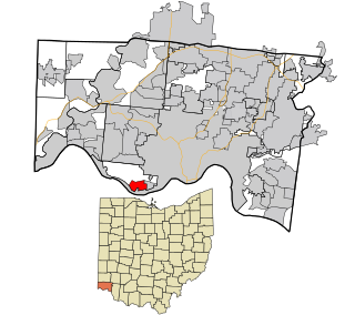
Washington is a city in Daviess County, Indiana. The population was 12,017 at the time of the 2020 census. The city is the county seat of Daviess County. It is also the principal city of the Washington, Indiana Micropolitan Statistical Area, which comprises all of Daviess County and had an estimated 2017 population of 31,648.

<span class="mw-page-title-main">Greendale, Indiana</span> City in Indiana, United States

Greendale is a city in Dearborn County, Indiana, United States. The population was 4,520 at the 2010 census.

<span class="mw-page-title-main">Hidden Valley, Indiana</span> Census-designated place in Indiana, United States

Hidden Valley is a private residential community in Dearborn County, Indiana, United States. For statistical purposes it is a census-designated place (CDP), with a population of 5,387 at the 2010 census, up from 4,417 at the 2000 census.

<span class="mw-page-title-main">Lawrenceburg, Indiana</span> City in Indiana, United States

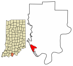
Lawrenceburg is a city and the county seat of Dearborn County, Indiana, United States. The population was 5,129 at the 2020 census. It is the largest city in Dearborn County. Lawrenceburg is in southeast Indiana, on the Ohio River west of Cincinnati.

<span class="mw-page-title-main">West Harrison, Indiana</span> Town in Indiana, United States

West Harrison is a town in Harrison Township, Dearborn County, Indiana, United States. The population was 289 at the 2010 census.

<span class="mw-page-title-main">Rising Sun, Indiana</span> City in Indiana, United States

Rising Sun is a city in Randolph Township and the county seat of Ohio County, Indiana, United States, along the Ohio River. It is also the only incorporated community in the county. The population of Rising Sun was 2,304 at the 2010 census.

<span class="mw-page-title-main">Cannelton, Indiana</span> City in Indiana, United States

Cannelton is a city in Troy Township, Perry County, in the U.S. state of Indiana, along the Ohio River. The population was 1,563 at the 2010 census. Cannelton, which was the smallest incorporated city in the state until 2010, was formerly the county seat of Perry County until the seat was relocated to Tell City.

<span class="mw-page-title-main">Troy, Indiana</span> Town in Indiana, United States

Troy is a town in Troy Township, Perry County, Indiana, along the Ohio River near the mouth of the Anderson River. It is the second oldest city in Indiana. The population was 385 at the 2010 census.

<span class="mw-page-title-main">Dale, Indiana</span> Town in Indiana, United States

Dale is a town in Carter Township, Spencer County, in the U.S. state of Indiana. The population was 1,593 at the 2010 census.

<span class="mw-page-title-main">Grandview, Indiana</span> Town in Indiana, United States

Grandview is a town in Hammond Township, Spencer County, Indiana, along the Ohio River. The population was 749 at the 2010 census.

<span class="mw-page-title-main">Rockport, Indiana</span> City in Indiana, United States

Rockport is a city in Ohio Township and the county seat of Spencer County, Indiana, along the Ohio River. The population was 2,270 at the 2010 census. Once the largest community in Spencer County, the city has recently been surpassed by the town of Santa Claus. At 37°53'1" north, Rockport is also the southernmost city in the state, located slightly south of Evansville, Cannelton, or Mount Vernon.

<span class="mw-page-title-main">Harrison, Ohio</span> City in Ohio, United States

Harrison is a city in western Hamilton County, Ohio, United States. The population was 12,563 at the 2020 census. It is part of the Cincinnati metropolitan area.

<span class="mw-page-title-main">Perry, Ohio</span> Village in Ohio, United States

Perry is a village in Lake County, Ohio, United States. The population was 1,602 at the 2020 census.

<span class="mw-page-title-main">Junction City, Ohio</span> Village in Ohio, United States

Junction City is a village in Perry County, Ohio, United States. The population was 721 at the 2020 census.

<span class="mw-page-title-main">New Lexington, Ohio</span> Village in Ohio, United States

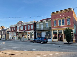
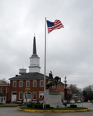
New Lexington is a village in and the county seat of Perry County, Ohio, United States, 21 miles (34 km) southwest of Zanesville and 45 miles (72 km) miles southeast of Columbus. The population was 4,435 at the 2020 census.

<span class="mw-page-title-main">Shawnee, Perry County, Ohio</span> Village in Ohio, United States

Shawnee is a village in Perry County, Ohio, United States. The population was 505 at the 2020 census. It is 9 miles (14 km) south of the county seat of New Lexington.

<span class="mw-page-title-main">Somerset, Ohio</span> Village in Ohio, United States

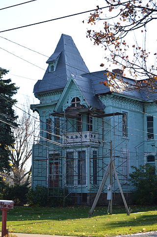
Somerset is a village in Perry County, Ohio, United States. The population was 1,481 at the 2020 census. It is located 9.5 miles (15.3 km) north of the county seat New Lexington and has a dedicated historical district. Saint Joseph Church, the oldest Catholic church in Ohio, is located just outside Somerset on State Route 383.

<span class="mw-page-title-main">Delhi Hills, Ohio</span> Census-designated place in Ohio, United States

Delhi Hills is a census-designated place (CDP) in Delhi Township, Hamilton County, Ohio, United States. The population was 5,022 at the 2020 census.

References

  1. "2020 U.S. Gazetteer Files". United States Census Bureau. Retrieved March 16, 2022.
  2. 1 2 U.S. Geological Survey Geographic Names Information System: Tell City, Indiana
  3. 1 2 "U.S. Census website". United States Census Bureau . Retrieved January 31, 2008.
  4. "Tell City, Indiana". Geographic Names Information System . United States Geological Survey, United States Department of the Interior . Retrieved April 14, 2017.
  5. Thrasher, M. A.: A History of Tell City Archived 2008-12-07 at the Wayback Machine , Tell City Historical Society, 1989. Retrieved 2008-12-04.
  6. "Perry County". Jim Forte Postal History. Retrieved April 14, 2017.
  7. "Around Town | Tell City Pilothouse".
  8. "Indiana public library directory" (PDF). Indiana State Library. Retrieved March 14, 2018.
  9. "G001 - Geographic Identifiers - 2010 Census Summary File 1". United States Census Bureau. Archived from the original on February 13, 2020. Retrieved July 29, 2015.
  10. "NOWData – NOAA Online Weather Data". National Oceanic and Atmospheric Administration. Retrieved November 18, 2023.
  11. "Summary of Monthly Normals 1991–2020". National Oceanic and Atmospheric Administration. Retrieved November 18, 2023.
  12. "Census of Population and Housing". Census.gov. Retrieved June 4, 2015.
  13. "U.S. Census website". United States Census Bureau . Retrieved December 11, 2012.