Portland, Indiana

Last updated

Portland, Indiana
Jay County Courthouse P4020129.jpg
Jay County Indiana Incorporated and Unincorporated areas Portland Highlighted 1861236.svg
Location of Portland in Jay County, Indiana
Coordinates: 40°26′08″N85°00′07″W / 40.43556°N 85.00194°W / 40.43556; -85.00194
Country United States
State Indiana
County Jay
Township Wayne
Government
   Mayor John Boggs (R)[ citation needed ]
Area
[1]
  Total4.88 sq mi (12.63 km2)
  Land4.87 sq mi (12.62 km2)
  Water0.00 sq mi (0.01 km2)  0.24%
Elevation
[2]
906 ft (276 m)
Population
 (2020)
  Total6,320
  Density1,296.94/sq mi (500.79/km2)
Time zone UTC-5 (EST)
  Summer (DST) UTC-4 (EDT)
ZIP code
47371
Area code 260
FIPS code 18-61236 [3]
GNIS feature ID2396259 [2]
Website www.thecityofportland.net

Portland is a city in and the county seat of Jay County, Indiana, United States. [4] The population was 6,223 at the 2010 census, [5] and in 2018 the estimated population was 6,085. [6]

Contents

History

Portland was platted in 1837. [7] It was named after Portland, Maine. [8]

The Jay County Courthouse, Portland Commercial Historic District, and Jonas Votaw House are listed on the National Register of Historic Places. [9]

Geography

According to the U.S. Census Bureau, Portland has a total area of 4.97 square miles (12.88 km2), of which 1.6 acres (6,524 m2), or 0.05%, are water. [10] The Salamonie River runs through the city just south of its center. The Salamonie is a west-flowing tributary of the Wabash River.

Climate

Climate data for Portland, Indiana (1991–2020 normals, extremes 1964–present)
MonthJanFebMarAprMayJunJulAugSepOctNovDecYear
Record high °F (°C)65
(18)
73
(23)
85
(29)
87
(31)
92
(33)
104
(40)
102
(39)
100
(38)
96
(36)
91
(33)
79
(26)
72
(22)
104
(40)
Mean maximum °F (°C)56.0
(13.3)
59.7
(15.4)
71.1
(21.7)
80.3
(26.8)
86.4
(30.2)
91.6
(33.1)
93.1
(33.9)
90.6
(32.6)
88.9
(31.6)
82.1
(27.8)
70.0
(21.1)
59.0
(15.0)
94.3
(34.6)
Mean daily maximum °F (°C)33.8
(1.0)
37.6
(3.1)
48.2
(9.0)
61.6
(16.4)
71.7
(22.1)
80.4
(26.9)
83.7
(28.7)
81.9
(27.7)
76.5
(24.7)
64.3
(17.9)
50.5
(10.3)
38.9
(3.8)
60.8
(16.0)
Daily mean °F (°C)25.4
(−3.7)
28.3
(−2.1)
37.9
(3.3)
49.7
(9.8)
60.4
(15.8)
69.6
(20.9)
72.8
(22.7)
70.8
(21.6)
64.4
(18.0)
52.7
(11.5)
40.8
(4.9)
30.9
(−0.6)
50.3
(10.2)
Mean daily minimum °F (°C)17.0
(−8.3)
19.0
(−7.2)
27.7
(−2.4)
37.8
(3.2)
49.2
(9.6)
58.7
(14.8)
61.9
(16.6)
59.6
(15.3)
52.3
(11.3)
41.1
(5.1)
31.1
(−0.5)
22.9
(−5.1)
39.9
(4.4)
Mean minimum °F (°C)−5.3
(−20.7)
−0.1
(−17.8)
9.1
(−12.7)
23.2
(−4.9)
34.9
(1.6)
45.4
(7.4)
51.5
(10.8)
49.2
(9.6)
37.8
(3.2)
29.0
(−1.7)
17.3
(−8.2)
5.8
(−14.6)
−8.0
(−22.2)
Record low °F (°C)−29
(−34)
−16
(−27)
−13
(−25)
10
(−12)
27
(−3)
38
(3)
40
(4)
38
(3)
28
(−2)
17
(−8)
4
(−16)
−21
(−29)
−29
(−34)
Average precipitation inches (mm)2.82
(72)
2.71
(69)
2.80
(71)
3.62
(92)
4.31
(109)
4.55
(116)
4.07
(103)
3.83
(97)
2.97
(75)
2.85
(72)
3.01
(76)
2.39
(61)
39.93
(1,014)
Average snowfall inches (cm)6.4
(16)
5.4
(14)
3.1
(7.9)
0.3
(0.76)
0.0
(0.0)
0.0
(0.0)
0.0
(0.0)
0.0
(0.0)
0.0
(0.0)
0.1
(0.25)
0.6
(1.5)
3.5
(8.9)
19.4
(49)
Average precipitation days (≥ 0.01 in)9.88.49.311.111.510.28.37.27.28.48.39.4109.1
Average snowy days (≥ 0.1 in)3.83.11.30.20.00.00.00.00.00.10.52.111.1
Source: NOAA [11] [12]

Demographics

Jay County Courthouse Jay County Courthouse P4020129.jpg
Jay County Courthouse
Historical population
CensusPop.Note
1870 462
1880 1,694266.7%
1890 3,725119.9%
1900 4,79828.8%
1910 5,1306.9%
1920 5,95816.1%
1930 5,276−11.4%
1940 6,36220.6%
1950 7,06411.0%
1960 6,999−0.9%
1970 7,1151.7%
1980 7,074−0.6%
1990 6,483−8.4%
2000 6,437−0.7%
2010 6,223−3.3%
2020 6,3201.6%
U.S. Decennial Census [13]

2010 census

At the 2010 census there were 6,223 people, 2,607 households, and 1,620 families living in the city. The population density was 1,338.3 inhabitants per square mile (516.7/km2). There were 3,005 housing units at an average density of 646.2 per square mile (249.5/km2). The racial makup of the city was 94.5% White, 0.4% African American, 0.5% Asian, 3.1% from other races, and 1.5% from two or more races. Hispanic or Latino of any race were 5.8%. [14]

Of the 2,607 households 30.4% had children under the age of 18 living with them, 42.7% were married couples living together, 14.0% single female householder, 5.4% single male householder, and 37.9% were non-families. 32.1% of households were one person and 14.2% were one person aged 65 or older. The average household size was 2.32 and the average family size was 2.89.

The median age was 39.4 years. 23.7% of residents were under the age of 18; 8.6% were between the ages of 18 and 24; 25.1% were from 25 to 44; 24.7% were from 45 to 64; and 17.9% were 65 or older. The gender makeup of the city was 46.8% male and 53.2% female.

Education

The town has a lending library, the Jay County Public Library. [15]

Notable people

Related Research Articles

<span class="mw-page-title-main">Darke County, Ohio</span> County in Ohio, United States

Darke County is a county in the U.S. state of Ohio. As of the 2020 census, the population was 51,881. Its county seat and largest city is Greenville. The county was created in 1809 and later organized in 1817. It is named for William Darke, an officer in the American Revolutionary War. Darke County comprises the Greenville, OH Micropolitan Statistical Area, which is also included in the Dayton-Springfield-Sidney, OH Combined Statistical Area.

<span class="mw-page-title-main">Wells County, Indiana</span> County in Indiana, United States

Wells County is a county in the U.S. state of Indiana. As of the 2020 United States Census, the population was 28,180. The county seat is Bluffton.

<span class="mw-page-title-main">Jay County, Indiana</span> County in Indiana, United States

Jay County is a county in the U.S. state of Indiana. As of 2020, the population was 20,478. The county seat is Portland.

<span class="mw-page-title-main">Huntington County, Indiana</span> County in Indiana, United States

Huntington County is a county in the U.S. state of Indiana. According to the 2020 United States Census, the population was 36,662. The county seat is Huntington.

<span class="mw-page-title-main">Dunkirk, Indiana</span> City in Indiana, United States

Dunkirk is a city in Blackford and Jay counties in the U.S. state of Indiana. The population was 2,164 at the 2020 census.

<span class="mw-page-title-main">Montpelier, Indiana</span> City in Indiana, United States

Montpelier is a city in Harrison Township, Blackford County, in the U.S. state of Indiana. This small rural community, the county's first to be platted, was established by settlers from Vermont, and is named after Vermont's capital city of Montpelier.

<span class="mw-page-title-main">Aurora, Indiana</span> City in Indiana, United States

Aurora is a city in Center Township, Dearborn County, Indiana, United States. The population was 3,750 at the 2010 census.

<span class="mw-page-title-main">Huntington, Indiana</span> City in Huntington County, Indiana, United States

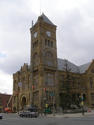
Huntington, known as the "Lime City", is the largest city in and the county seat of Huntington County, Indiana, United States. It is in Huntington and Union townships. It is also part of Fort Wayne, Indiana's metropolitan area. The population was 17,022 at the 2020 census.

<span class="mw-page-title-main">Warren, Indiana</span> Town in Indiana, United States

Warren is a town in Salamonie Township, Huntington County, Indiana. The population of Warren was 1,182 at the time of the 2020 census.

<span class="mw-page-title-main">Pennville, Indiana</span> Town in Indiana, United States

Pennville is a town in Penn Township, Jay County, Indiana, United States. The population was 701 at the 2010 census.

<span class="mw-page-title-main">Salamonia, Indiana</span> Town in Indiana, United States

Salamonia is a town in Madison Township, Jay County, Indiana, United States. The population was 157 at the 2010 census. The town is situated along the Salamonie River, near its headwaters in Northern Indiana.

<span class="mw-page-title-main">Summitville, Indiana</span> Town in Indiana, United States

Summitville is a town in Van Buren Township, Madison County, Indiana, United States. It is part of the Indianapolis–Carmel–Anderson metropolitan statistical area. The population was 989 at the 2020 census.

<span class="mw-page-title-main">Kendallville, Indiana</span> City in Indiana, United States

Kendallville is a city in Wayne Township, Noble County, in the U.S. state of Indiana. The population was 10,205 at the 2021 census.

<span class="mw-page-title-main">Rising Sun, Indiana</span> City in Indiana, United States

Rising Sun is a city in Randolph Township and the county seat of Ohio County, Indiana, United States, along the Ohio River. It is also the only incorporated community in the county. The population of Rising Sun was 2,304 at the 2010 census.

<span class="mw-page-title-main">Rockville, Indiana</span> Town in Indiana, United States

Rockville is a town in Adams Township, Parke County, in the U.S. state of Indiana. The population was 2,607 at the 2010 census. The town is the county seat of Parke County. It is known as "The Covered Bridge Capital of the World".

<span class="mw-page-title-main">Rushville, Indiana</span> City in Indiana, United States

Rushville is a city in Rushville Township, Rush County, in the U.S. state of Indiana. The population was 6,185 at the 2020 census. The city is the county seat of Rush County. It, like the county, was named in honor of Dr. Benjamin Rush, who signed the Declaration of Independence.

<span class="mw-page-title-main">Sullivan, Indiana</span> City in Indiana, United States

Sullivan is a city in Hamilton Township, Sullivan County, Indiana, United States. The population was 4,249 at the 2010 census. It is part of the Terre Haute Metropolitan Statistical Area. The city is the county seat of Sullivan County.

<span class="mw-page-title-main">Liberty, Indiana</span> Town in Indiana, United States

Liberty is a town in and the county seat of Union County, Indiana, United States, located about 5 miles (8.0 km) west of the state's border with Ohio. The population was 2,000 at the 2020 census.

<span class="mw-page-title-main">Lagro, Indiana</span> Town in Indiana, United States

Lagro is a town in Lagro Township, Wabash County, in the U.S. state of Indiana. The population was 415 at the 2010 census.

<span class="mw-page-title-main">East Wheatfield Township, Indiana County, Pennsylvania</span> Township in Pennsylvania, United States

East Wheatfield Township is a township in Indiana County, Pennsylvania, United States. East Wheatfield Township was created when the original Wheatfield Township was divided in 1859 into East and West Wheatfield. It was named for the large unforested areas naturally occurring there which were ideal for growing wheat. The population was 2,161 at the 2020 census, a decline from the figure of 2,366 tabulated in 2010. It includes the communities of Boltz, Cramer, Gas Center, Ninevah, Robindale, Shoupstown, Virginia, and Wheatfield. It surrounds, but does not include, the borough of Armagh.

References

  1. "2020 U.S. Gazetteer Files". United States Census Bureau. Retrieved March 16, 2022.
  2. 1 2 U.S. Geological Survey Geographic Names Information System: Portland, Indiana
  3. "U.S. Census website". United States Census Bureau . Retrieved January 31, 2008.
  4. "Find a County". National Association of Counties. Retrieved June 7, 2011.
  5. "Geographic Identifiers: 2010 Census Summary File 1 (G001): Portland city, Indiana". American Factfinder. U.S. Census Bureau. Archived from the original on February 13, 2020. Retrieved May 16, 2018.
  6. "Population and Housing Unit Estimates" . Retrieved September 7, 2019.
  7. "Incorporated Cities and Towns". Jay County Historical Society. Archived from the original on May 29, 2014. Retrieved May 28, 2014.
  8. Baker, Ronald L. (October 1995). From Needmore to Prosperity: Hoosier Place Names in Folklore and History. Indiana University Press. p. 269. ISBN   978-0-253-32866-3. ...named for his hometown, Portland, Maine.
  9. "National Register Information System". National Register of Historic Places . National Park Service. July 9, 2010.
  10. "2016 U.S. Gazetteer Files". United States Census Bureau. Retrieved July 28, 2017.
  11. "NOWData – NOAA Online Weather Data". National Oceanic and Atmospheric Administration. Retrieved November 18, 2023.
  12. "Summary of Monthly Normals 1991–2020". National Oceanic and Atmospheric Administration. Retrieved November 18, 2023.
  13. "Census of Population and Housing". Census.gov. Retrieved June 4, 2015.
  14. "U.S. Census website". United States Census Bureau . Retrieved February 8, 2017.
  15. "Indiana public library directory" (PDF). Indiana State Library. Retrieved March 8, 2018.