Washington, Indiana

Last updated

Washington, Indiana
Daviess County Courthouse in Washington.jpg
Daviess County courthouse in Washington
Motto(s): 
"A City of Pride and Progress"
Daviess County Indiana Incorporated and Unincorporated areas Washington Highlighted 1880504.svg
Location of Washington in Daviess County, Indiana.
Coordinates: 38°39′31″N87°09′33″W / 38.65861°N 87.15917°W / 38.65861; -87.15917
Country United States
State Indiana
County Daviess
Township Washington
Government
   Mayor Dave Rhodes (D) [1]
Area
[2]
  Total6.67 sq mi (17.27 km2)
  Land6.63 sq mi (17.17 km2)
  Water0.04 sq mi (0.11 km2)  0.84%
Elevation
[3]
532 ft (162 m)
Population
 (2020) [4]
  Total12,017
  Density1,890.16/sq mi (729.79/km2)
Time zone UTC-5 (EST)
  Summer (DST) UTC-4 (EDT)
ZIP code
47501
Area code(s) 812, 930
FIPS code 18-80504 [5]
GNIS feature ID2397205 [3]
Website http://www.washingtonin.us

Washington is a city in Daviess County, Indiana. The population was 12,017 at the time of the 2020 census. The city is the county seat of Daviess County. [6] It is also the principal city of the Washington, Indiana Micropolitan Statistical Area, which comprises all of Daviess County and had an estimated 2017 population of 31,648.

Contents

History

Washington was platted in 1815. [7] It was named from Washington Township. [8]

The railroad was built through Washington in 1857. [9] By 1889, it was a major depot and repair yard for the Ohio and Mississippi Railroad. The Baltimore and Ohio Railroad took over the line in 1893. During this time, the railroad employed over 1,000 workers. [10]

On November 17, 2013, an EF2 tornado tore through the western edge of the city destroying 20 homes and severely damaging 20 others. [11] [12]

The Magnus J. Carnahan House, Daviess County Courthouse, Thomas Faith House, Robert C. Graham House, Dr. John A. Scudder House, Washington Commercial Historic District, and Dr. Nelson Wilson House are listed on the National Register of Historic Places. [13]

Geography

W According to the 2010 census, Washington has a total area of 4.767 square miles (12.35 km2), of which 4.73 square miles (12.25 km2) (or 99.22%) is land and 0.037 square miles (0.10 km2) (or 0.78%) is water. [14]

Climate

Washington has a humid subtropical climate (Köppen classification Cfa), with four distinct seasons. Winters are cool to chilly with moderate snowfall, while summers are warm and humid.

Climate data for Washington (1 mile W), Indiana (1991-2020 normals, extremes 1896–present)
MonthJanFebMarAprMayJunJulAugSepOctNovDecYear
Record high °F (°C)76
(24)
77
(25)
89
(32)
93
(34)
100
(38)
107
(42)
113
(45)
108
(42)
106
(41)
96
(36)
84
(29)
75
(24)
113
(45)
Mean daily maximum °F (°C)40.4
(4.7)
45.6
(7.6)
56.5
(13.6)
68.5
(20.3)
77.4
(25.2)
85.0
(29.4)
87.4
(30.8)
86.3
(30.2)
81.1
(27.3)
69.9
(21.1)
55.6
(13.1)
44.7
(7.1)
66.5
(19.2)
Daily mean °F (°C)32.1
(0.1)
36.6
(2.6)
46.2
(7.9)
56.9
(13.8)
66.7
(19.3)
74.4
(23.6)
77.1
(25.1)
75.7
(24.3)
69.3
(20.7)
58.4
(14.7)
46.0
(7.8)
36.5
(2.5)
56.3
(13.5)
Mean daily minimum °F (°C)23.9
(−4.5)
27.5
(−2.5)
35.8
(2.1)
45.4
(7.4)
56.0
(13.3)
63.9
(17.7)
66.8
(19.3)
65.1
(18.4)
57.6
(14.2)
46.9
(8.3)
36.4
(2.4)
28.4
(−2.0)
46.1
(7.8)
Record low °F (°C)−18
(−28)
−19
(−28)
−4
(−20)
19
(−7)
28
(−2)
38
(3)
47
(8)
42
(6)
29
(−2)
18
(−8)
−2
(−19)
−19
(−28)
−19
(−28)
Average rainfall inches (mm)3.59
(91)
2.88
(73)
4.02
(102)
4.83
(123)
5.51
(140)
5.15
(131)
4.14
(105)
3.17
(81)
3.50
(89)
3.60
(91)
3.91
(99)
3.68
(93)
47.98
(1,218)
Average snowfall inches (cm)2.9
(7.4)
2.0
(5.1)
1.0
(2.5)
0
(0)
0
(0)
0
(0)
0
(0)
0
(0)
0
(0)
0.1
(0.25)
0.1
(0.25)
3.1
(7.9)
9.2
(23.4)
Source: NOAA [15]

Demographics

Historical population
CensusPop.Note
1850 675 [16]
1870 2,901
1880 4,32349.0%
1890 6,06440.3%
1900 8,55141.0%
1910 7,854−8.2%
1920 8,74311.3%
1930 9,0703.7%
1940 9,3122.7%
1950 10,98718.0%
1960 10,846−1.3%
1970 11,3584.7%
1980 11,325−0.3%
1990 10,838−4.3%
2000 11,3805.0%
2010 11,5091.1%
2020 12,0174.4%
U.S. Decennial Census [17]

2010 census

As of the census [4] of 2010, there were 11,509 people, 4,558 households, and 2,849 families living in the city. The population density was 2,433.2 inhabitants per square mile (939.5/km2). There were 5,067 housing units at an average density of 1,071.2 per square mile (413.6/km2). The racial makeup of the city was 89.2% White, 1.1% African American, 0.3% Native American, 1.1% Asian, 0.1% Pacific Islander, 6.4% from other races, and 1.9% from two or more races. Hispanic or Latino of any race were 9.6% of the population.

There were 4,558 households, of which 33.4% had children under the age of 18 living with them, 41.8% were married couples living together, 15.2% had a female householder with no husband present, 5.5% had a male householder with no wife present, and 37.5% were non-families. 31.8% of all households were made up of individuals, and 14.9% had someone living alone who was 65 years of age or older. The average household size was 2.43 and the average family size was 3.04.

The median age in the city was 37.3 years. 25.5% of residents were under the age of 18; 9.4% were between the ages of 18 and 24; 24% were from 25 to 44; 25.2% were from 45 to 64; and 15.9% were 65 years of age or older. The gender makeup of the city was 48.2% male and 51.8% female.

2000 census

As of the census [5] of 2000, there were 11,380 people, 4,658 households, and 2,897 families living in the city. The population density was 2,404.0 inhabitants per square mile (928.2/km2). There were 5,077 housing units at an average density of 1,072.5 per square mile (414.1/km2). The racial makeup of the city was 95.30% White, 0.91% African American, 0.30% Native American, 0.39% Asian, 0.05% Pacific Islander, 2.20% from other races, and 0.85% from two or more races. Hispanic or Latino of any race were 4.15% of the population.

There were 4,658 households, out of which 30.6% had children under the age of 18 living with them, 45.9% were married couples living together, 12.5% had a female householder with no husband present, and 37.8% were non-families. 33.2% of all households were made up of individuals, and 16.1% had someone living alone who was 65 years of age or older. The average household size was 2.36 and the average family size was 2.99.

In the city, the population was spread out, with 25.5% under the age of 18, 8.3% from 18 to 24, 26.1% from 25 to 44, 21.7% from 45 to 64, and 18.3% who were 65 years of age or older. The median age was 38 years. For every 100 females, there were 89.7 males. For every 100 females age 18 and over, there were 84.7 males.

The median income for a household in the city was $29,055, and the median income for a family was $37,713. Males had a median income of $30,570 versus $19,306 for females. The per capita income for the city was $16,721. About 9.8% of families and 14.3% of the population were below the poverty line, including 19.3% of those under age 18 and 10.4% of those age 65 or over.

Transportation

Transit

Washington Transit System operates bus service in the city on weekdays.

Highways

Education

The town has a free lending library, the Washington Carnegie Public Library. [18]

Washington Community Schools [19] include:

Arts and culture

Washington still retains a number of architecturally historical buildings. The Helphenstine House, built in 1847, displays Greek Revival architecture styles. The Robert C. Graham House was owned by an Indiana car manufacturer and was built in 1912. It is an example of Frank Lloyd Wright's Prairie School of Architecture and is listed on the National Register of Historic Places. It has marble fireplaces, crystal-glass French windows, a billiards room and parquet floors. On Main Street of Washington is the Daviess County Historical Society Museum, [20] a collection of history related to Daviess County and Indiana. The museum features a funeral practices exhibit, a military history room, an art gallery, a Civil War display with an 1855 slave collar and a Civil War era regimental flag, a school room, and an archives room for genealogists as well as a gift shop.

The Washington Browns was a minor league baseball team in Washington that played in the Class C Central League in 1897 and were immediately preceded by the Washington Giants, who were members of the Independent level 1896 Kentucky-Indiana League.

Notable people

Related Research Articles

<span class="mw-page-title-main">Hancock County, Kentucky</span> County in Kentucky, United States

Hancock County is a county located in the U.S. state of Kentucky. As of the 2020 census, the population was 9,095. Its county seat is in the city of Hawesville located in the Northern part of the county, and its largest city of Lewisport is located in the Northwestern part of the county.

<span class="mw-page-title-main">Daviess County, Indiana</span> County in Indiana, United States

Daviess County is a county in the U.S. state of Indiana. As of the 2020 United States Census, the population was 33,381. The county seat is Washington. About 15% of the county's population is Amish of Swiss origin, as of 2017.

<span class="mw-page-title-main">Cherryland, California</span> Unincorporated Community in California, United States

Cherryland is an unincorporated community and census-designated place (CDP) in Alameda County, California, United States. Cherryland is located between Ashland to the north and the city of Hayward to the south. The population was 15,808 at the 2020 census.

<span class="mw-page-title-main">Tamalpais-Homestead Valley, California</span> Census-designated place in California, United States

Tamalpais-Homestead Valley is a census-designated place (CDP) in Marin County, California, United States. The population was 11,492 at the 2020 census.

<span class="mw-page-title-main">East Dubuque, Illinois</span> City in Illinois, United States

East Dubuque is a city in Jo Daviess County, Illinois, United States. The population was 1,505 at the 2020 census, down from 1,704 in 2010. East Dubuque is located alongside the Mississippi River. Across the river is the city of Dubuque, Iowa. The city limits extend along the river to the Illinois – Wisconsin border.

<span class="mw-page-title-main">Charlestown, Indiana</span> City in Indiana, United States

Charlestown is a city located within Charlestown Township, in Clark County, Indiana, United States. The population was 7,775 at the 2020 census.

<span class="mw-page-title-main">Alfordsville, Indiana</span> Town in Indiana, United States

Alfordsville is a town in Reeve Township, Daviess County, Indiana, United States. The population was 101 at the 2010 census.

<span class="mw-page-title-main">Cannelburg, Indiana</span> Town in Indiana, United States

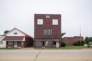
Cannelburg is a town in Barr Township, Daviess County, Indiana, United States. The population was 135 at the 2010 census.

<span class="mw-page-title-main">Elnora, Indiana</span> Town in Indiana, United States

Elnora is a town in Elmore Township, Daviess County, Indiana, United States. The population was 640 at the 2010 census.

<span class="mw-page-title-main">Montgomery, Indiana</span> Town in Indiana, United States

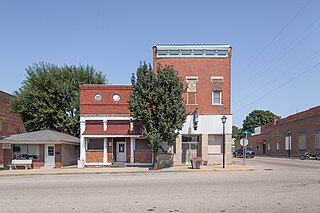
Montgomery is a town in Barr Township, Daviess County, Indiana, United States. The population was 343 at the 2010 census.

<span class="mw-page-title-main">Odon, Indiana</span> Town in Indiana, United States

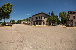
Odon is a town in Madison Township, Daviess County, Indiana, United States. The population was 1,354 at the 2010 census.

<span class="mw-page-title-main">Plainville, Indiana</span> Town in Indiana, United States

Plainville is a town in Steele Township, Daviess County, Indiana, United States. The population was 476 at the 2010 census. The former high school mascot was the Plainville Midgets.

<span class="mw-page-title-main">Switz City, Indiana</span> Town in Indiana, United States

Switz City is a town in Fairplay and Grant townships, Greene County, Indiana, United States. The population was 293 at the 2010 census. It is part of the Bloomington, Indiana, Metropolitan Statistical Area.

<span class="mw-page-title-main">Bicknell, Indiana</span> City in Indiana, United States

Bicknell is a city in Knox County, Indiana, United States. The population was 2,915 at the 2010 census.

<span class="mw-page-title-main">Bruceville, Indiana</span> Town in Indiana, United States

Bruceville is a town in Washington Township, Knox County, Indiana, United States. The population was 478 at the 2010 census.

<span class="mw-page-title-main">Crane, Indiana</span> Town in Indiana, United States

Crane is a town in Perry Township, Martin County, in the U.S. state of Indiana. The population was 166 at the 2020 census. The community is adjacent to the Naval Surface Warfare Center Crane Division.

<span class="mw-page-title-main">Loogootee, Indiana</span> City in Indiana, United States

Loogootee is a city in Perry Township, Martin County, in the U.S. state of Indiana. The population was 2,601 at the time of the 2020 census.

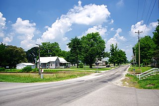
New Ross is a town in Walnut Township, Montgomery County, in the U.S. state of Indiana. As of the 2020 census, the town population was 309.

<span class="mw-page-title-main">Gallatin, Missouri</span> City in Missouri, United States

Gallatin is a city in Daviess County, Missouri, United States. The population was 1,821 at the 2020 census. It is the county seat of Daviess County.

<span class="mw-page-title-main">Jamesport, Missouri</span> City in Missouri, United States

Jamesport is a city in eastern Daviess County, Missouri, United States. The population was 559 at the 2020 census.

References

  1. "Mayor's Office".
  2. "2019 U.S. Gazetteer Files". United States Census Bureau. Retrieved July 16, 2020.
  3. 1 2 U.S. Geological Survey Geographic Names Information System: Washington, Indiana
  4. 1 2 "U.S. Census website". United States Census Bureau . Retrieved December 11, 2012.
  5. 1 2 "U.S. Census website". United States Census Bureau . Retrieved January 31, 2008.
  6. "Find a County". National Association of Counties. Retrieved June 7, 2011.
  7. Hellmann, Paul T. (February 14, 2006). Historical Gazetteer of the United States. Routledge. p. 332. ISBN   1-135-94859-3.
  8. Baker, Ronald L. (October 1995). From Needmore to Prosperity: Hoosier Place Names in Folklore and History . Indiana University Press. p.  338. ISBN   978-0-253-32866-3. The present name is for Washington Township...
  9. History of Knox and Daviess County, Indiana: From the Earliest Time to the Present; with Biographical Sketches, Reminiscences, Notes, Etc. ; Together with an Extended History of the Colonial Days of Vincennes, and Its Progress Down to the Formation of the State Government. Goodspeed. 1886. p.  678.
  10. Douglas Wissing (March 1, 2001). Scenic Driving Indiana. Globe Pequot. p. 4. ISBN   978-1-56044-906-5 . Retrieved November 23, 2011.
  11. "Tornado Destroys 20 Homes, Cuts Power In Washington, Ind". Indiana Public Media. Retrieved December 19, 2013.
  12. "Preliminary reports show 11 tornadoes hit Indiana". Fox 59 News. November 18, 2013. Retrieved December 19, 2013.
  13. "National Register Information System". National Register of Historic Places . National Park Service. July 9, 2010.
  14. "G001 - Geographic Identifiers - 2010 Census Summary File 1". United States Census Bureau. Archived from the original on February 13, 2020. Retrieved July 29, 2015.
  15. "NowData – NOAA Online Weather Data". National Oceanic and Atmospheric Administration. Retrieved November 28, 2021.
  16. DeBow, J.D.B. (1853). The Seventh Census of the United States: 1850 (PDF). Washington: Robert Armstrong. p. 1021. Retrieved May 19, 2021. The population figure for 1850 is an approximation provided in the appendix of the official volume of the Seventh Census.
  17. "Census of Population and Housing". Census.gov. Retrieved June 4, 2015.
  18. "Indiana public library directory" (PDF). Indiana State Library. Retrieved March 4, 2018.
  19. "Schools". Washington Community Schools. Retrieved February 17, 2023.
  20. "What is Daviess County History?". DAVIESS COUNTY HISTORY.