Plainville, Indiana

Last updated

Plainville, Indiana
Plainville, Indiana.jpg
Daviess County Indiana Incorporated and Unincorporated areas Plainville Highlighted 1860264.svg
Location of Plainville in Daviess County, Indiana.
Coordinates: 38°48′17″N87°09′05″W / 38.80472°N 87.15139°W / 38.80472; -87.15139
Country United States
State Indiana
County Daviess
Township Steele
Area
[1]
  Total0.34 sq mi (0.89 km2)
  Land0.34 sq mi (0.89 km2)
  Water0.00 sq mi (0.00 km2)
Elevation
[2]
472 ft (144 m)
Population
 (2020)
  Total499
  Density1,446.38/sq mi (558.19/km2)
Time zone UTC-6 (Central (CST))
  Summer (DST) UTC-5 (CDT)
ZIP code
47568
Area code 812
FIPS code 18-60264 [3]
GNIS feature ID2396860 [2]

Plainville is a town in Steele Township, Daviess County, Indiana, United States. The population was 476 at the 2010 census. The former high school mascot was the Plainville Midgets.

Contents

History

Plainville was laid out in 1855. [4] It was likely named from the flatness of the land. [5]

Geography

According to the 2010 census, Plainville has a total area of 0.35 square miles (0.91 km2), all land. [6]

Demographics

Historical population
CensusPop.Note
1880 91
1930 603
1940 6192.7%
1950 568−8.2%
1960 545−4.0%
1970 538−1.3%
1980 5563.3%
1990 444−20.1%
2000 51315.5%
2010 476−7.2%
2020 4994.8%
U.S. Decennial Census [7]

2010 census

As of the census [8] of 2010, there were 476 people, 194 households, and 132 families residing in the town. The population density was 1,360.0 inhabitants per square mile (525.1/km2). There were 219 housing units at an average density of 625.7 per square mile (241.6/km2). The racial makeup of the town was 97.7% White, 0.4% African American, 1.1% Asian, and 0.8% from two or more races. Hispanic or Latino of any race were 0.4% of the population.

There were 194 households, of which 34.5% had children under the age of 18 living with them, 49.5% were married couples living together, 12.9% had a female householder with no husband present, 5.7% had a male householder with no wife present, and 32.0% were non-families. 29.4% of all households were made up of individuals, and 10.8% had someone living alone who was 65 years of age or older. The average household size was 2.41 and the average family size was 2.91.

The median age in the town was 39.4 years. 27.3% of residents were under the age of 18; 4.9% were between the ages of 18 and 24; 24% were from 25 to 44; 25.9% were from 45 to 64; and 18.1% were 65 years of age or older. The gender makeup of the town was 50.2% male and 49.8% female.

2000 census

As of the census [3] of 2000, there were 513 people, 210 households, and 145 families residing in the town. The population density was 1,555.3 inhabitants per square mile (600.5/km2). There were 231 housing units at an average density of 700.3 per square mile (270.4/km2). The racial makeup of the town was 98.25% White, 0.78% Native American, 0.19% Asian, 0.39% from other races, and 0.39% from two or more races. Hispanic or Latino of any race were 2.34% of the population.

There were 210 households, out of which 32.4% had children under the age of 18 living with them, 58.1% were married couples living together, 8.6% had a female householder with no husband present, and 30.5% were non-families. 28.1% of all households were made up of individuals, and 18.1% had someone living alone who was 65 years of age or older. The average household size was 2.40 and the average family size was 2.92.

In the town, the population was spread out, with 25.3% under the age of 18, 5.7% from 18 to 24, 30.4% from 25 to 44, 18.3% from 45 to 64, and 20.3% who were 65 years of age or older. The median age was 38 years. For every 100 females, there were 94.3 males. For every 100 females age 18 and over, there were 87.7 males.

The median income for a household in the town was $37,969, and the median income for a family was $45,455. Males had a median income of $30,865 versus $18,750 for females. The per capita income for the town was $16,335. About 8.3% of families and 9.8% of the population were below the poverty line, including 12.4% of those under age 18 and 13.3% of those age 65 or over.

Related Research Articles

<span class="mw-page-title-main">Utica, Indiana</span> Town in Indiana, United States

Utica is a town in Utica Township, Clark County, Indiana, United States. The population was 776 at the 2010 census.

<span class="mw-page-title-main">Kirklin, Indiana</span> Town in Indiana, United States

Kirklin is a town in Kirklin Township, Clinton County, Indiana, United States. The population was 788 at the 2010 census. The town was named for Nathan Kirk, a local pioneer settler.

<span class="mw-page-title-main">Alfordsville, Indiana</span> Town in Indiana, United States

Alfordsville is a town in Reeve Township, Daviess County, Indiana, United States. The population was 101 at the 2010 census.

<span class="mw-page-title-main">Cannelburg, Indiana</span> Town in Indiana, United States

Cannelburg is a town in Barr Township, Daviess County, Indiana, United States. The population was 135 at the 2010 census.

<span class="mw-page-title-main">Elnora, Indiana</span> Town in Indiana, United States

Elnora is a town in Elmore Township, Daviess County, Indiana, United States. The population was 640 at the 2010 census.

<span class="mw-page-title-main">Montgomery, Indiana</span> Town in Indiana, United States

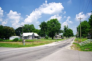
Montgomery is a town in Barr Township, Daviess County, Indiana, United States. The population was 343 at the 2010 census.

<span class="mw-page-title-main">Odon, Indiana</span> Town in Indiana, United States

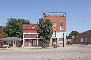
Odon is a town in Madison Township, Daviess County, Indiana, United States. The population was 1,354 at the 2010 census.

<span class="mw-page-title-main">Fowlerton, Indiana</span> Town in Indiana, United States

Fowlerton is a town in Fairmount Township, Grant County, Indiana, United States. The population was 261 at the 2010 census.

<span class="mw-page-title-main">Van Buren, Indiana</span> Town in Indiana, United States

Van Buren is a town in Van Buren Township, Grant County, Indiana, United States. The population was 864 at the 2010 census.

<span class="mw-page-title-main">Bruceville, Indiana</span> Town in Indiana, United States

Bruceville is a town in Washington Township, Knox County, Indiana, United States. The population was 478 at the 2010 census.

<span class="mw-page-title-main">Decker, Indiana</span> Town in Indiana, United States

Decker is a town in Johnson Township, Knox County, Indiana, United States. The population was 249 at the 2010 census. It was founded in 1869 by Isaac Decker. Decker is near the White River, and is well known for the watermelon and cantaloupe produced in the surrounding rural area.

<span class="mw-page-title-main">Wheatland, Indiana</span> Town in Indiana, United States

Wheatland is a town in Steen Township, Knox County, Indiana, United States. The population was 480 at the 2010 census.

<span class="mw-page-title-main">Country Club Heights, Indiana</span> Town in Indiana, United States

Country Club Heights is a town in Anderson Township, Madison County, Indiana, United States. The population was 98 at the 2020 census.

<span class="mw-page-title-main">Crane, Indiana</span> Town in Indiana, United States

Crane is a town in Perry Township, Martin County, in the U.S. state of Indiana. The population was 166 at the 2020 census. The community is adjacent to the Naval Surface Warfare Center Crane Division.

<span class="mw-page-title-main">Dale, Indiana</span> Town in Indiana, United States

Dale is a town in Carter Township, Spencer County, in the U.S. state of Indiana. The population was 1,593 at the 2010 census.

<span class="mw-page-title-main">Clarks Hill, Indiana</span> Town in Indiana, United States

Clarks Hill is a town in Lauramie Township, Tippecanoe County, in the U.S. state of Indiana. The population was 611 at the 2010 census.

Stoneham is a town in Oxford County, Maine, United States. The population was 261 at the 2020 census.

<span class="mw-page-title-main">Dell Prairie, Wisconsin</span> Town in Wisconsin, United States

Dell Prairie is a town in Adams County in the U.S. state of Wisconsin. The population was 1,590 at the 2010 census. The unincorporated community of Plainville is located in the town.

<span class="mw-page-title-main">Rocky Ripple, Indiana</span> Town in Indiana, United States

Rocky Ripple is a town in Marion County, Indiana, United States. The population was 655 at the 2020 census. It was founded in 1927, and the town was incorporated as an "included town" as part of Unigov in 1970. It is part of Indianapolis, but retains a separate functioning town government under IC 36-3-1-11. Although not far from the city center, Rocky Ripple is a somewhat isolated area, located between the Central Canal and the White River; only two traffic-supporting bridges over the canal provide access to the town.

<span class="mw-page-title-main">Williams Creek, Indiana</span> Town in Indiana, United States

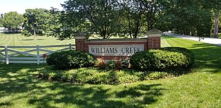
Williams Creek is a town in Washington Township, Marion County, Indiana, United States. It is located about 9 miles (14 km) north of downtown Indianapolis. The population was 430 at the 2020 census. It has existed as an "included town" since 1970, when it was incorporated into Indianapolis as part of Unigov. It is part of Indianapolis, but retains a functioning town government under IC 36-3-1-11.

References

  1. "2020 U.S. Gazetteer Files". United States Census Bureau. Retrieved March 16, 2022.
  2. 1 2 U.S. Geological Survey Geographic Names Information System: Plainville, Indiana
  3. 1 2 "U.S. Census website". United States Census Bureau . Retrieved January 31, 2008.
  4. History of Knox and Daviess County, Indiana: From the Earliest Time to the Present. Goodspeed. 1886. pp.  708.
  5. Baker, Ronald L. (October 1995). From Needmore to Prosperity: Hoosier Place Names in Folklore and History . Indiana University Press. p.  266. ISBN   978-0-253-32866-3. ...for the level terrain of the site.
  6. "G001 - Geographic Identifiers - 2010 Census Summary File 1". United States Census Bureau. Archived from the original on February 13, 2020. Retrieved July 17, 2015.
  7. "Census of Population and Housing". Census.gov. Retrieved June 4, 2015.
  8. "U.S. Census website". United States Census Bureau . Retrieved December 11, 2012.