Winamac, Indiana

Last updated

Winamac, Indiana
Pulaski County Courthouse Winimac Indiana P1300092.jpg
Pulaski County Courthouse
Motto: 
"Built On The Tippecanoe River" [1]
Pulaski County Indiana Incorporated and Unincorporated areas Winamac Highlighted 1884734.svg
Location of Winamac in Pulaski County, Indiana.
Coordinates: 41°03′13″N86°36′13″W / 41.05361°N 86.60361°W / 41.05361; -86.60361
Country United States
State Indiana
County Pulaski
Township Monroe
Founded byJohn Pearson
Area
[2]
  Total1.36 sq mi (3.53 km2)
  Land1.36 sq mi (3.53 km2)
  Water0.00 sq mi (0.00 km2)
Elevation
[3]
702 ft (214 m)
Population
 (2020)
  Total2,318
  Density1,703.16/sq mi (657.42/km2)
Time zone UTC-5 (Eastern(EST))
  Summer (DST) UTC-4 (EDT)
ZIP code
46996
Area code 574
FIPS code 18-84734 [4]
GNIS feature ID2397747 [3]

Winamac is a town in Monroe Township, Pulaski County, in the U.S. state of Indiana. [3] The population was 2,490 at the 2010 census. It is the county seat of Pulaski County. [5] [6]

Contents

History

The town's name came from the Potawatomi word for "catfish." [6] It was selected as the county seat in 1839. [7] Winamac was incorporated as a town in 1868. [8]

The Winamac post office has been in operation since 1839. [9]

Pulaski County Courthouse, Dr. George W. Thompson House, and Vurpillat's Opera House are listed on the National Register of Historic Places. [10]

Notable Landmarks

Winamac has several local landmarks scattered throughout the town.

The Artesian Well [11]

In June 1877, the Winamac Gas and Oil company began drilling near the Tippecanoe River. Instead of oil, they discovered a water vein at 264 feet below the ground. In the following years, demand for the well's water created a small industry within the community, and local boys ventured to earn money by delivering this water to homes. During this time, the water was marketed as containing healing properties. Interest in the well had died down by the end of the 19th century. By 1920, the well had fallen victim to vandalism and decay, and was subsequently repaired. Unfortunately, the well's water pressure was later compromised by other local projects, causing it to dry up. It was capped, and an informational plaque was dedicated to the well on the 100th anniversary of its drilling. Today, it stands as a reminder of local history on the west side of the town park.

The Memorial Swinging Bridge [12]

The Winamac Town Park is home to a large suspension bridge over the Tippecanoe River. This bridge was dedicated on July 4, 1923, in honor of soldiers and sailors from the Civil War onward. It has since been a popular local attraction, serving as the subject of many greeting cards and photoshoots since its dedication.

In 2020, the "Light Up Our Legacy Project" [13] began, hoping to raise money to install LED lights on the bridge. The goal was reached, and the bridge underwent renovations through early spring of 2023, with the goal of unveiling the lights on July 4, 2023.

Geography

According to the 2010 census, Winamac has a total area of 1.36 square miles (3.52 km2), all land. [14]

Climate

Climate data for Winamac, Indiana (1991–2020 normals, extremes 1897–1906, 1918–present)
MonthJanFebMarAprMayJunJulAugSepOctNovDecYear
Record high °F (°C)71
(22)
75
(24)
86
(30)
92
(33)
96
(36)
108
(42)
109
(43)
103
(39)
101
(38)
92
(33)
82
(28)
71
(22)
109
(43)
Mean maximum °F (°C)54.3
(12.4)
57.3
(14.1)
70.9
(21.6)
80.2
(26.8)
87.9
(31.1)
91.9
(33.3)
92.1
(33.4)
90.9
(32.7)
89.8
(32.1)
82.4
(28.0)
69.0
(20.6)
57.1
(13.9)
94.0
(34.4)
Mean daily maximum °F (°C)32.5
(0.3)
36.3
(2.4)
47.8
(8.8)
60.7
(15.9)
71.8
(22.1)
80.7
(27.1)
83.5
(28.6)
81.9
(27.7)
76.6
(24.8)
64.2
(17.9)
49.1
(9.5)
37.2
(2.9)
60.2
(15.7)
Daily mean °F (°C)24.1
(−4.4)
27.3
(−2.6)
37.6
(3.1)
49.5
(9.7)
60.8
(16.0)
70.1
(21.2)
73.0
(22.8)
71.3
(21.8)
64.8
(18.2)
52.9
(11.6)
40.1
(4.5)
29.5
(−1.4)
50.1
(10.1)
Mean daily minimum °F (°C)15.8
(−9.0)
18.3
(−7.6)
27.5
(−2.5)
38.3
(3.5)
49.8
(9.9)
59.4
(15.2)
62.6
(17.0)
60.6
(15.9)
53.1
(11.7)
41.7
(5.4)
31.0
(−0.6)
21.8
(−5.7)
40.0
(4.4)
Mean minimum °F (°C)−6.1
(−21.2)
−1.0
(−18.3)
11.4
(−11.4)
23.7
(−4.6)
34.9
(1.6)
44.8
(7.1)
51.3
(10.7)
50.8
(10.4)
39.8
(4.3)
28.2
(−2.1)
17.0
(−8.3)
3.1
(−16.1)
−9.9
(−23.3)
Record low °F (°C)−29
(−34)
−21
(−29)
−9
(−23)
8
(−13)
22
(−6)
32
(0)
41
(5)
34
(1)
24
(−4)
16
(−9)
−10
(−23)
−25
(−32)
−29
(−34)
Average precipitation inches (mm)2.52
(64)
2.07
(53)
2.49
(63)
3.71
(94)
4.10
(104)
4.27
(108)
4.73
(120)
4.18
(106)
3.36
(85)
3.16
(80)
2.84
(72)
2.38
(60)
39.81
(1,011)
Average snowfall inches (cm)9.5
(24)
6.5
(17)
3.5
(8.9)
0.4
(1.0)
0.0
(0.0)
0.0
(0.0)
0.0
(0.0)
0.0
(0.0)
0.0
(0.0)
0.0
(0.0)
1.0
(2.5)
5.6
(14)
26.5
(67)
Average precipitation days (≥ 0.01 in)10.78.59.811.112.711.710.49.49.110.710.010.5124.6
Average snowy days (≥ 0.1 in)4.93.71.80.30.00.00.00.00.00.00.83.314.8
Source: NOAA [15] [16]

Demographics

Historical population
CensusPop.Note
1860 206
1870 906339.8%
1880 835−7.8%
1890 1,21545.5%
1900 1,68438.6%
1910 1,607−4.6%
1920 1,6844.8%
1930 1,679−0.3%
1940 1,8359.3%
1950 2,16618.0%
1960 2,3759.6%
1970 2,341−1.4%
1980 2,3701.2%
1990 2,262−4.6%
2000 2,4186.9%
2010 2,4903.0%
2020 2,320−6.8%
U.S. Decennial Census [17]

2010 census

As of the census [18] of 2010, there were 2,490 people, 1,028 households, and 617 families living in the town. The population density was 1,830.9 inhabitants per square mile (706.9/km2). There were 1,140 housing units at an average density of 838.2 per square mile (323.6/km2). The racial makeup of the town was 97.2% White, 0.5% African American, 0.3% Native American, 0.4% Asian, 0.3% from other races, and 1.2% from two or more races. Hispanic or Latino of any race were 2.3% of the population.

There were 1,028 households, of which 31.3% had children under the age of 18 living with them, 41.8% were married couples living together, 13.1% had a female householder with no husband present, 5.1% had a male householder with no wife present, and 40.0% were non-families. 36.1% of all households were made up of individuals, and 17.3% had someone living alone who was 65 years of age or older. The average household size was 2.29 and the average family size was 2.97.

The median age in the town was 38.8 years. 23.7% of residents were under the age of 18; 9% were between the ages of 18 and 24; 25.2% were from 25 to 44; 25.6% were from 45 to 64; and 16.3% were 65 years of age or older. The gender makeup of the town was 48.8% male and 51.2% female.

2000 census

As of the census [4] of 2000, there were 2,418 people, 988 households, and 607 families living in the town. The population density was 1,872.5 inhabitants per square mile (723.0/km2). There were 1,079 housing units at an average density of 835.6 per square mile (322.6/km2). The racial makeup of the town was 97.39% White, 0.70% African American, 0.21% Native American, 0.12% Asian, 0.04% Pacific Islander, 0.17% from other races, and 1.36% from two or more races. Hispanic or Latino of any race were 1.28% of the population.

There were 988 households, out of which 29.5% had children under the age of 18 living with them, 46.8% were married couples living together, 10.9% had a female householder with no husband present, and 38.5% were non-families. 34.9% of all households were made up of individuals, and 19.1% had someone living alone who was 65 years of age or older. The average household size was 2.27 and the average family size was 2.93.

In the town, the population was spread out, with 23.6% under the age of 18, 8.9% from 18 to 24, 26.1% from 25 to 44, 19.6% from 45 to 64, and 21.7% who were 65 years of age or older. The median age was 38 years. For every 100 females, there were 86.4 males. For every 100 females age 18 and over, there were 83.1 males.

The median income for a household in the town was $31,413, and the median income for a family was $43,824. Males had a median income of $29,667 versus $22,461 for females. The per capita income for the town was $16,447. About 5.3% of families and 8.2% of the population were below the poverty line, including 11.9% of those under age 18 and 11.7% of those age 65 or over.

Education

The community is located in the Eastern Pulaski Community School Corporation. [19]

The town has a lending library, the Pulaski County Public Library. [20]

Economy

BraunAbility is based in Winamac.

Notable people

Related Research Articles

<span class="mw-page-title-main">Pulaski County, Indiana</span> County of Indiana, United States

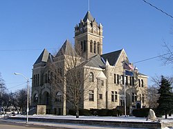
Pulaski County is a county located in the U.S. state of Indiana. According to the 2020 U.S. census, the population was 12,514. The county seat is Winamac.

<span class="mw-page-title-main">Alexander, Arkansas</span> City in Arkansas, United States

Alexander is a city in Pulaski and Saline counties in the U.S. state of Arkansas. Located in Central Arkansas, the town was founded as a construction camp for the nearby railroad. Following its completion, the citizens decided to incorporate in 1887. Alexander is home to the Arkansas Juvenile Assessment and Treatment Center. The population was 2,901 at the 2010 census.

<span class="mw-page-title-main">Edgewood, Indiana</span> Town in Indiana, United States

Edgewood is a town in Anderson Township, Madison County, Indiana, United States. It is part of the Indianapolis–Carmel–Anderson metropolitan statistical area. The population was 2,053 at the 2020 census.

<span class="mw-page-title-main">Markleville, Indiana</span> Town in Indiana, United States

Markleville is a town in Adams Township, Madison County, Indiana, United States. It is part of the Indianapolis–Carmel–Anderson metropolitan statistical area. The population was 484 at the 2020 census.

<span class="mw-page-title-main">River Forest, Indiana</span> Town in Indiana, United States

River Forest is a town in Anderson Township, Madison County, Indiana, United States. It is part of the Indianapolis–Carmel–Anderson metropolitan statistical area. The population was 26 at the 2020 census.

<span class="mw-page-title-main">Amboy, Indiana</span> Town in Indiana, United States

Amboy is a town in Jackson Township, Miami County, in the U.S. state of Indiana. The population was 317 at the 2020 census, down from 384 in 2010.

<span class="mw-page-title-main">Alamo, Indiana</span> Town in Indiana, United States

Alamo is a town in Ripley Township, Montgomery County, in the U.S. state of Indiana. The population was 66 at the 2020 census, unchanged from 2010.

<span class="mw-page-title-main">Monrovia, Indiana</span> Town in Indiana, United States

Monrovia is a town in Monroe Township, Morgan County, in the U.S. state of Indiana. The population was 1,643 at the 2020 census, up from 1,063 in 2010.

<span class="mw-page-title-main">Mecca, Indiana</span> Town in Indiana, United States

Mecca is a town in Wabash Township, Parke County, in the U.S. state of Indiana. The population was 335 at the 2010 census.

<span class="mw-page-title-main">Rockville, Indiana</span> Town in Indiana, United States

Rockville is a town in Adams Township, Parke County, in the U.S. state of Indiana. The population was 2,607 at the 2010 census. The town is the county seat of Parke County. It is known as "The Covered Bridge Capital of the World".

<span class="mw-page-title-main">Winslow, Indiana</span> Town in Indiana, United States

Winslow is a town in Patoka Township, Pike County, in the U.S. state of Indiana. The population was 864 at the 2010 census. It is part of the Jasper Micropolitan Statistical Area.

<span class="mw-page-title-main">Francesville, Indiana</span> Town in Indiana, United States

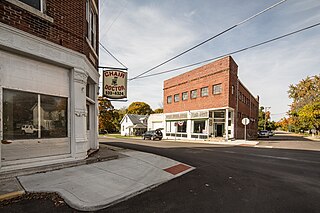
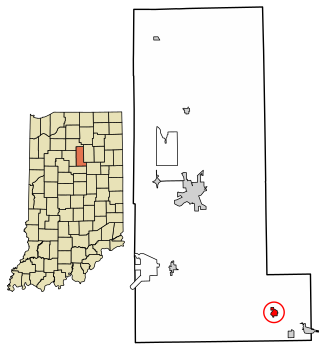
Francesville is a town in Salem Township, Pulaski County, in the U.S. state of Indiana. The population was 852 at the 2020 census. The motto for Francesville is “A small town with a big heart.”

<span class="mw-page-title-main">Medaryville, Indiana</span> Town in Indiana, United States

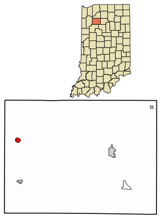
Medaryville is a town in White Post Township, Pulaski County, in the U.S. state of Indiana. The population was 614 at the 2010 census.

<span class="mw-page-title-main">Monterey, Indiana</span> Town in Indiana, United States

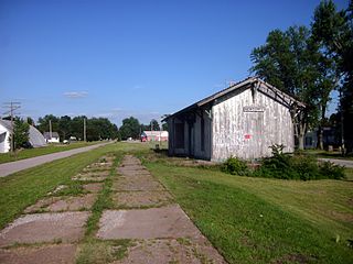
Monterey is a town in Tippecanoe Township, Pulaski County, in the U.S. state of Indiana. The population was 218 at the 2010 census.

<span class="mw-page-title-main">Star City, Indiana</span> Census-designated place in Indiana, United States

Star City is a census-designated place (CDP) in Van Buren Township, Pulaski County, in the U.S. state of Indiana. The population was 344 at the 2010 census.

<span class="mw-page-title-main">Burnettsville, Indiana</span> Town in Indiana, United States

Burnettsville is a town in Jackson Township, White County, in the U.S. state of Indiana. The population was 346 at the 2010 census.

<span class="mw-page-title-main">Reynolds, Indiana</span> Town in Indiana, United States

Reynolds is a town in Honey Creek Township, White County, in the U.S. state of Indiana. The population was 533 at the 2010 census.

<span class="mw-page-title-main">North Crows Nest, Indiana</span> Town in Indiana, United States

North Crows Nest is a town in Washington Township, Marion County, Indiana, United States. It is approximately 7 miles (11 km) north of downtown Indianapolis. The population was 44 at the 2020 census. It has existed as an "included town" since 1970, when it was incorporated into Indianapolis as part of Unigov. It is part of Indianapolis, but retains town governmental powers under IC 36-3-1-11.

<span class="mw-page-title-main">Rocky Ripple, Indiana</span> Town in Indiana, United States

Rocky Ripple is a town in Marion County, Indiana, United States. The population was 655 at the 2020 census. It was founded in 1927, and the town was incorporated as an "included town" as part of Unigov in 1970. It is part of Indianapolis, but retains a separate functioning town government under IC 36-3-1-11. Although not far from the city center, Rocky Ripple is a somewhat isolated area, located between the Central Canal and the White River; only two traffic-supporting bridges over the canal provide access to the town.

<span class="mw-page-title-main">Pulaski, Wisconsin</span> Village in Wisconsin, United States

Pulaski is a village in Brown, Oconto, and Shawano counties in the U.S. state of Wisconsin. The population was 3,539 at the 2010 census. Of this, 3,321 were in Brown County, 218 in Shawano County, and none in Oconto County.

References

  1. "Town of Winamac Indiana". Town of Winamac Indiana. Retrieved September 29, 2012.
  2. "2020 U.S. Gazetteer Files". United States Census Bureau. Retrieved March 16, 2022.
  3. 1 2 3 U.S. Geological Survey Geographic Names Information System: Winamac, Indiana
  4. 1 2 "U.S. Census website". United States Census Bureau . Retrieved January 31, 2008.
  5. "Find a County". National Association of Counties. Retrieved June 7, 2011.
  6. 1 2 "Profile for Winamac, Indiana, IN". ePodunk. Archived from the original on June 16, 2017. Retrieved September 29, 2012.
  7. Pulaski county Indiana history
  8. Counties of White and Pulaski, Indiana: Historical and Biographical. F.A. Battey & Company. 1883. p.  522.
  9. "Pulaski County". Jim Forte Postal History. Retrieved April 1, 2017.
  10. "National Register Information System". National Register of Historic Places . National Park Service. July 9, 2010.
  11. "Winamac Town Park: Artesian Well – Pulaski County Historical Museum" . Retrieved April 10, 2023.
  12. "Memorial Swinging Bridge – Pulaski County Historical Museum" . Retrieved April 10, 2023.
  13. "Light Up Our Legacy!". Memorial Swinging Bridge Project. August 13, 2020. Retrieved April 10, 2023.
  14. "G001 - Geographic Identifiers - 2010 Census Summary File 1". United States Census Bureau. Archived from the original on February 13, 2020. Retrieved July 25, 2015.
  15. "NOWData – NOAA Online Weather Data". National Oceanic and Atmospheric Administration. Retrieved November 18, 2023.
  16. "Summary of Monthly Normals 1991–2020". National Oceanic and Atmospheric Administration. Retrieved November 18, 2023.
  17. "Census of Population and Housing". Census.gov. Retrieved June 4, 2015.
  18. "U.S. Census website". United States Census Bureau . Retrieved December 11, 2012.
  19. "2020 CENSUS - SCHOOL DISTRICT REFERENCE MAP: Pulaski County, IN" (PDF). U.S. Census Bureau . Retrieved August 19, 2023.
  20. "Indiana public library directory" (PDF). Indiana State Library. Archived from the original (PDF) on February 18, 2017. Retrieved March 14, 2018.
  21. 'Illinois Blue Book 2001-2002,' Biographical Sketch of Judith A. Myers, pg. 124
  22. "RIDDICK, Carl Wood, (1872 - 1960)". Biographical Directory of the United States Congress. Retrieved October 14, 2012.