Plymouth, Indiana

Last updated

Plymouth, Indiana
Downtown Plymouth IN 2.JPG
Downtown Plymouth
Marshall County Indiana Incorporated and Unincorporated areas Plymouth Highlighted 1860822.svg
Location of Plymouth in Marshall County, Indiana.
Coordinates: 41°20′38″N86°18′45″W / 41.34389°N 86.31250°W / 41.34389; -86.31250
Country United States
State Indiana
County Marshall
Government
   Mayor Robert Listenberger (D)
Area
[1]
  Total7.62 sq mi (19.74 km2)
  Land7.57 sq mi (19.61 km2)
  Water0.05 sq mi (0.13 km2)  0.53%
Elevation
797 ft (243 m)
Population
 (2020)
  Total10,214
  Density1,349.10/sq mi (520.88/km2)
Time zone UTC-5 (EST)
  Summer (DST) UTC-4 (EDT)
ZIP code
46563
Area code 574
FIPS code 18-60822 [2]
GNIS feature ID0441379 [3]
Website plymouthin.com

Plymouth is a city in Marshall County, Indiana, United States. The population is 10,214 in the 2020 census. It is the county seat of Marshall County. [4] Plymouth was the site of the first retail outlet of defunct U.S. retailer Montgomery Ward in 1926.

Contents

Geography

Plymouth, Indiana is located at 41°20′38″N86°18′45″W / 41.34389°N 86.31250°W / 41.34389; -86.31250 (41.343894, -86.312544), [5] along the Yellow River. [6]

According to the 2010 census, Plymouth has a total area of 7.57 square miles (19.61 km2), of which 7.53 square miles (19.50 km2) (or 99.47%) is land and 0.04 square mile (0.1 km2) (or 0.53%) is water. [7]

Plymouth downtown from above Plymouth-indiana-from-above.jpg
Plymouth downtown from above

Climate

Climate data for Plymouth, Indiana (1991–2020 normals, extremes 1894–present)
MonthJanFebMarAprMayJunJulAugSepOctNovDecYear
Record high °F (°C)69
(21)
74
(23)
87
(31)
90
(32)
97
(36)
105
(41)
109
(43)
103
(39)
102
(39)
93
(34)
82
(28)
71
(22)
109
(43)
Mean maximum °F (°C)53.7
(12.1)
56.8
(13.8)
70.4
(21.3)
80.3
(26.8)
88.1
(31.2)
93.0
(33.9)
93.5
(34.2)
91.8
(33.2)
89.6
(32.0)
82.1
(27.8)
68.1
(20.1)
56.3
(13.5)
94.9
(34.9)
Mean daily maximum °F (°C)31.4
(−0.3)
35.4
(1.9)
47.1
(8.4)
59.8
(15.4)
71.2
(21.8)
80.6
(27.0)
83.8
(28.8)
81.9
(27.7)
76.1
(24.5)
63.3
(17.4)
48.4
(9.1)
36.7
(2.6)
59.6
(15.3)
Daily mean °F (°C)24.1
(−4.4)
26.9
(−2.8)
37.4
(3.0)
48.9
(9.4)
60.3
(15.7)
70.0
(21.1)
73.2
(22.9)
71.5
(21.9)
64.8
(18.2)
52.8
(11.6)
40.1
(4.5)
29.8
(−1.2)
50.0
(10.0)
Mean daily minimum °F (°C)16.7
(−8.5)
18.5
(−7.5)
27.7
(−2.4)
38.0
(3.3)
49.4
(9.7)
59.3
(15.2)
62.7
(17.1)
61.0
(16.1)
53.5
(11.9)
42.4
(5.8)
31.8
(−0.1)
23.0
(−5.0)
40.3
(4.6)
Mean minimum °F (°C)−5.6
(−20.9)
−0.6
(−18.1)
10.4
(−12.0)
23.0
(−5.0)
33.5
(0.8)
44.3
(6.8)
50.2
(10.1)
49.8
(9.9)
39.0
(3.9)
28.8
(−1.8)
17.6
(−8.0)
3.8
(−15.7)
−9.0
(−22.8)
Record low °F (°C)−22
(−30)
−20
(−29)
−6
(−21)
16
(−9)
26
(−3)
36
(2)
42
(6)
42
(6)
30
(−1)
25
(−4)
6
(−14)
−17
(−27)
−22
(−30)
Average precipitation inches (mm)2.63
(67)
2.33
(59)
2.45
(62)
3.63
(92)
4.33
(110)
4.24
(108)
4.39
(112)
4.05
(103)
3.20
(81)
3.38
(86)
3.03
(77)
2.60
(66)
40.26
(1,023)
Average snowfall inches (cm)18.6
(47)
14.1
(36)
6.4
(16)
1.1
(2.8)
0.0
(0.0)
0.0
(0.0)
0.0
(0.0)
0.0
(0.0)
0.0
(0.0)
0.1
(0.25)
3.3
(8.4)
11.3
(29)
54.9
(139)
Average extreme snow depth inches (cm)7.8
(20)
7.5
(19)
3.7
(9.4)
0.5
(1.3)
0.0
(0.0)
0.0
(0.0)
0.0
(0.0)
0.0
(0.0)
0.0
(0.0)
0.0
(0.0)
1.6
(4.1)
4.4
(11)
10.7
(27)
Average precipitation days (≥ 0.01 in)13.510.411.412.412.811.19.69.89.210.711.712.7135.3
Average snowy days (≥ 0.1 in)8.97.13.61.10.00.00.00.00.00.12.26.529.5
Source: NOAA [8] [9] [10]

Demographics

Historical population
CensusPop.Note
1860 1,277
1870 2,48294.4%
1880 2,5703.5%
1890 2,7286.1%
1900 3,65634.0%
1910 3,8385.0%
1920 4,33813.0%
1930 5,29021.9%
1940 5,7138.0%
1950 6,70417.3%
1960 7,55812.7%
1970 7,6611.4%
1980 7,6930.4%
1990 8,3037.9%
2000 9,84018.5%
2010 10,0332.0%
2020 10,2141.8%
U.S. Decennial Census [11]

2010 census

As of the census of 2010, [12] there were 10,033 people, 3,940 households, and 2,401 families residing in the city. The population density was 1,332.4 inhabitants per square mile (514.4/km2). There were 4,451 housing units at an average density of 591.1 per square mile (228.2/km2). The racial makeup of the city was 87.2% White, 0.9% African American, 0.6% Native American, 0.5% Asian, 8.3% from other races, and 2.5% from two or more races. Hispanic or Latino of any race were 20.0% of the population.

There were 3,940 households, of which 34.6% had children under the age of 18 living with them, 39.7% were married couples living together, 14.9% had a female householder with no husband present, 6.3% had a male householder with no wife present, and 39.1% were non-families. 33.5% of all households were made up of individuals, and 15% had someone living alone who was 65 years of age or older. The average household size was 2.49 and the average family size was 3.19.

The median age in the city was 34.3 years. 27.9% of residents were under the age of 18; 9.3% were between the ages of 18 and 24; 25.9% were from 25 to 44; 21.9% were from 45 to 64; and 15.2% were 65 years of age or older. The gender makeup of the city was 47.9% male and 52.1% female.

2000 census

As of the census of 2000, [2] there were 9,840 people, 3,838 households, and 2,406 families residing in the city. The population density was 1,414.0 inhabitants per square mile (545.9/km2). There were 4,100 housing units at an average density of 589.2 per square mile (227.5/km2). The racial makeup of the city was 80.80% White, 0.63% African American, 0.45% Native American, 0.50% Asian, 6.19% from other races, and 1.43% from two or more races. Hispanic or Latino of any race were 14.99% of the population.

There were 3,838 households, out of which 31.9% had children under the age of 18 living with them, 45.3% were married couples living together, 12.2% had a female householder with no husband present, and 37.3% were non-families. 31.4% of all households were made up of individuals, and 14.4% had someone living alone who was 65 years of age or older. The average household size was 2.48 and the average family size was 3.11.

In the city, the population was spread out, with 26.1% under the age of 18, 12.4% from 18 to 24, 28.8% from 25 to 44, 18.0% from 45 to 64, and 14.8% who were 65 years of age or older. The median age was 32 years. For every 100 females, there were 93.5 males. For every 100 females age 18 and over, there were 89.5 males.

The median income for a household in the city was $34,505, and the median income for a family was $41,447. Males had a median income of $30,444 versus $21,293 for females. The per capita income for the city was $15,417. About 10.4% of families and 13.1% of the population were below the poverty line, including 15.9% of those under age 18 and 9.6% of those age 65 or over.

History

Historic fire station with patchwork quilt designs on doors Plymouth IN Firestation.JPG
Historic fire station with patchwork quilt designs on doors
Centennial Park on N. Michigan Street (SR 17) Plymouth-indiana-centennial-park.jpg
Centennial Park on N. Michigan Street (SR 17)
Marshall County courthouse Marshall Co IN Courthouse.JPG
Marshall County courthouse

Early history

This area was part of the territory of the Potawatomi Native Americans, one of the historical tribes encountered by American settlers. In the nineteenth century, the United States government made numerous treaties to buy and extinguish Native American claims to land in the former Northwest Territory and the Southeast.

First settlements

Marshall County was formed in 1836, during the early years of settlement and before the forced removal of the Potawatomi people in 1838. It was named for U.S. Chief Justice John Marshall, who died in 1835. [13] Marshall County is notable as the starting point in 1838 of the Potawatomi Trail of Death, which was the forced removal by United States forces of Chief Menominee and 859 Potawatomi Indians from Indiana to Indian Territory, at the site of present-day Osawatomie, Kansas, a distance of 660 miles (1,060 km). The first settlers arrived in what is now Marshall County in 1835. They arrived as a result of the end of the Black Hawk War as well as the completion of the Erie Canal. They consisted primarily of settlers from New England, "Yankees" descended from the English Puritans who settled New England in the colonial era. They were mainly members of the Congregational church, although due to the Second Great Awakening many of them had converted to Methodism and some had become Baptists before coming to what is now Marshall County. As a result of this heritage, some place names in Marshall County are named after places in New England, such as Plymouth, which is named after Plymouth, Massachusetts, the site where the Mayflower landed in 1620. [14] When these settlers arrived, there was nothing but a dense virgin forest and wild marshland, which would need to be cleared and drained before it could be farmed. The Indian Removal Act of 1830 authorized forcible removal if necessary. The United States government purchased this area under the Treaty of Tippecanoe in 1832. Plymouth was incorporated as a town in 1851. [15]

Potawatomi Relocation

Although many Potawatomi had relocated to Indian Territory in present-day Kansas, Chief Menominee and his band of the Yellow River refused to go. Militia under the authority of United States Army officers rounded them up and in September 1838, the band of 859 headed west, in what became known as the Potawatomi Trail of Death. They traveled more than 660 miles to Osawatomie, Kansas, with many of the Potawatomi walking. More than 40 of the tribal members died on the march. [16]

American Civil War

During the Civil War, Union Army soldiers arrested Daniel E. VanValkenburgh, editor of the Plymouth Weekly Democrat, who criticized what he viewed as Lincoln's abuses of power. VanValkenburgh also criticized Department of Ohio commander Ambrose Burnside's lieutenant, General Milo S. Hascall. Hascall was in charge of the District of Indiana. VanValkenburgh called Hascall a donkey in the pages of the Democrat. Hascall promptly dispatched soldiers to arrest VanValkenburgh and brought him before Burnside to answer charges of violating Burnside's General Order No. 38. Burnside let VanValkenburgh off with a warning. The Democrat became the first of eleven Democratic newspapers suppressed or threatened with suppression in May 1863. [17]

History as a Sundown Town

Like many towns and counties in Indiana following the Reconstruction Era, Plymouth was once considered a Sundown town. [18] There are many accounts by locals claiming the existence of signs at the northern city limits stating, "Blacks out of town by sundown" or "All non-residents are required to leave the city by 9 pm", with a city ordinance listed at the bottom. There were no such signs at the southern border of town on US 31, nor on the east and west entrances on US 30. North of Plymouth, on US 31, is the city of South Bend, which has a large African-American population. [19] These signs remained posted well into the mid 60s until the Fair Housing Act of 1968 which banned racial discrimination in the sale, rental, and financing of housing. Although the city has since become more inclusive, the African-American population still remains remarkably low at 0.6%. [20] As of today, there has been no public acknowledgment by the city of its history of exclusion. [21]

Later History

On July 6, 1915 the Liberty Bell stopped in Plymouth on its trip from Philadelphia to the Exposition at San Francisco. [22] [23]

Much of Plymouth's history was documented in two major newspapers during the 19th century. The Marshall County Republican (also titled Plymouth Republican and Plymouth Tribune) operated from 1856 to 1922. [24] Its main rival the Marshall County Democrat (also titled Plymouth Democrat) appeared from 1855 to 1932 (and as a weekly only edition until January 1, 1941). [25] During the 20th century, the Plymouth Daily Pilot acquired the Republican in 1922, and the Democrat became the Plymouth Daily News in 1932. The News and Pilot merged to become the Plymouth Pilot-News in 1947.

As part of Plymouth's sesquicentennial celebration in 1966, organizers created the first Marshall County Blueberry Festival, to take place over Labor Day weekend. This tradition has continued annually, and the Festival typically brings in tens of thousands of visitors over the four-day event. [26]

In July 1982, five firefighters were killed when their fire truck overturned while responding to a call. The tanker truck crashed on a curve near West School on state road 17.

The East Laporte Street Footbridge, Heminger Travel Lodge, Marshall County Courthouse, Plymouth Downtown Historic District, Plymouth Northside Historic District, Plymouth Southside Historic District, and Plymouth Fire Station are listed on the National Register of Historic Places. [27] [28] [29]

Economy

As the center of commerce for Marshall County, Plymouth provides a large percentage of jobs in the manufacturing, retail, and service sectors. Major manufacturing employers include Hoosier Racing Tire, Zentis, Oasis Lifestyle, Pregis Innovative Packaging, Pretzels Inc. and the Maax Corporation. Eight U.S. manufacturing headquarters are located in Plymouth: Oasis Lifestyle, American Containers, Inc., Arrow Services, Inc., Indiana Tool & Manufacturing, Co. Inc (ITAMCO) U.S. Granules Corp., Wiers Manufacturing, Inc. and Zentis North America, LLC. [30]

Parks and recreation

Centennial Park

Plymouth is home to nine parks. Centennial Park is the largest park in Plymouth. It is equipped with a swimming pool, lighted baseball and softball diamonds, lighted basketball courts, lighted tennis courts, sand volleyball courts, shuffleboard, horseshoes, a skate park, and multiple playgrounds. The large wooden castle playground was built in 1993. Another smaller, metal playground with swings and a climbing wall is a part of Centennial Park as well. Centennial Park also includes a dog park and a 2.7-mile-long (4.3 km) Greenway Trail that connects several parks. [31]

Blueberry Festival

Each year over Labor Day weekend, Centennial Park is host to the Marshall County Blueberry Festival. The Blueberry Festival is Indiana's 3rd largest festival by attendance [32] and has been named a "Top 100 Event" in North America by the American Bus Association three times. Over 300 craft vendors and 100 food vendors from all across the United States showcase their goods. The festival also includes the Hoosier Old Wheels Antique Car Show, the Blueberry Stomp 5K/15K run, Bicycle Cruise, hot air balloon launches, a parade, and fireworks display. There are several sporting events, and three stages with free entertainment for festival goers. For a small fee, festival goers can play carnival games and ride carnival rides. [33]

River Park Square

River Park Square is located downtown and is the newest park in the city, opening in 2014. River Park Square consists of a stage, tiered seating, a splash pad, and a concession and bathroom building. It is home to Plymouth's Saturday Farmer's Market, the Yellow River Festival, the Latino Festival, and Mayor's Month of Music on Friday's in August. The Farmer's Market takes place every Saturday morning from May to October.

Packard's Woods

Packard's Wood Park also has athletic facilities and offers an all-inclusive play center called Freedom Park. Magnetic Park contains a playground, a fishing pond, and a gazebo with a fountain as well as the Conservation Clubhouse, which is able to be rented out for events. [31]

Points of interest

The town has a lending library, the Plymouth Public Library. The library, located on North Center Street, has worked hard to be useful for all different groups and individuals. According to the Plymouth Public Library website, “The Library's broad purpose, based upon provisions in the Indiana Code, is fulfilling ‘the educational informational, and recreational interests and needs of the public.'" [34] [35]

Notable people

Military and politics

Entertainers

Athletes and Coaches

Related Research Articles

<span class="mw-page-title-main">Goshen, Indiana</span> City in Indiana, United States

Goshen is a city in and the county seat of Elkhart County, Indiana, United States. It is the smaller of the two principal cities of the Elkhart–Goshen Metropolitan Statistical Area, which in turn is part of the South Bend–Elkhart–Mishawaka Combined Statistical Area. It is located in the northern part of Indiana near the Michigan border, in a region known as Michiana. Goshen is located 10 miles southeast of Elkhart, 25 miles southeast of South Bend, 120 miles east of Chicago, and 150 miles north of Indianapolis. The population was 34,517 at the 2020 census.

<span class="mw-page-title-main">Steuben County, Indiana</span> County in Indiana, United States

Steuben County is a county in the northeast corner of the U.S. state of Indiana. As of the 2020 United States Census the county population was 34,435. The county seat is Angola. Steuben County comprises the Angola, IN Micropolitan Statistical Area.

<span class="mw-page-title-main">Marshall County, Indiana</span> County in Indiana, United States

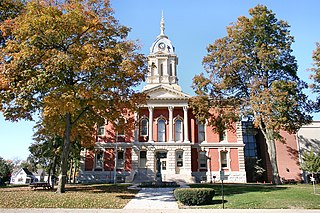
Marshall County is a county in the U.S. state of Indiana. The 2020 census recorded the population at 46,095. The county seat is Plymouth.

<span class="mw-page-title-main">Elkhart County, Indiana</span> County in Indiana, United States

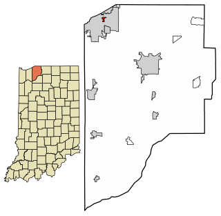
Elkhart County is a county located in the U.S. state of Indiana. As of 2020, the county's population was 207,047. The county seat is Goshen. Elkhart County is part of the Elkhart-Goshen Metropolitan Statistical Area, which in turn is part of the South Bend-Elkhart-Mishawaka Combined Statistical Area. It is also considered part of the broader region of Northern Indiana known as Michiana, and is 20 miles (32 km) east of South Bend, Indiana, 110 miles (180 km) east of Chicago, Illinois, and 150 miles (240 km) north of Indianapolis, Indiana. The area is referred to by locals as the recreation vehicle (RV) capital of the world and is known for its sizable Amish and Old Order Mennonite population.

<span class="mw-page-title-main">Goshen, Connecticut</span> Town in Connecticut, United States

Goshen is a town in Litchfield County, Connecticut, United States. The population was 3,150 at the 2020 census. The town is part of the Northwest Hills Planning Region.

<span class="mw-page-title-main">Elkhart, Indiana</span> City in Indiana, United States

Elkhart is a city in Elkhart County, Indiana, United States. The city is located 15 miles (24 km) east of South Bend, Indiana, 110 miles (180 km) east of Chicago, Illinois, and 150 miles (240 km) north of Indianapolis, Indiana. Elkhart has the larger population of the two principal cities of the Elkhart-Goshen Metropolitan Statistical Area, which in turn is part of the South Bend-Elkhart-Mishawaka Combined Statistical Area, in a region commonly known as Michiana. The population was 53,923 at the 2020 census. Despite the shared name and being the most populous city in the county, it is not the county seat of Elkhart County; that position is held by the city of Goshen, located about 10 miles (16 km) southeast of Elkhart.

<span class="mw-page-title-main">Middlebury, Indiana</span> Town in Indiana, United States

Middlebury is a town in Middlebury Township, Elkhart County, Indiana, United States. It is located approximately 35 miles east of South Bend, 130 miles east of Chicago, Illinois and 165 miles north of Indianapolis. Middlebury is nestled in Northern Indiana's Amish country. As of the 2010 census, the town population was 3,420.

<span class="mw-page-title-main">Franklin, Indiana</span> City in Indiana, United States

Franklin is a city in Johnson County, Indiana, United States. The population was 23,712 at the 2010 census. Located about 20 miles (32 km) south of Indianapolis, the city is the county seat of Johnson County. The site of Franklin College, the city attracts numerous regional sports fans for the college teams, as well as audiences for its art events.

<span class="mw-page-title-main">Hobart, Indiana</span> City in Indiana, United States

Hobart is a city in Lake County, Indiana, United States. The population was 29,752 at the 2020 census, up from 29,059 in 2010. It has been historically primarily residential, though recent annexation has added a notable retail corridor to the city.

<span class="mw-page-title-main">Merrillville, Indiana</span> Town in Indiana, United States

Merrillville is a town in Ross Township, Lake County, Indiana, United States. The population was 35,246 at the 2010 census. Merrillville is in east-central Lake County, in the Chicago metropolitan area. On January 1, 2015, Merrillville became the most populated town in Indiana, as Fishers in Hamilton County was converted from a town to a city. The town serves as a major shopping hub for Northwest Indiana.

<span class="mw-page-title-main">Pottawattamie Park, Indiana</span> Town in Indiana, United States

Pottawattamie Park is a town in Michigan Township, LaPorte County, Indiana, United States. The population was 235 at the 2010 census. It is included in the Michigan City, Indiana-La Porte, Indiana Metropolitan Statistical Area.

<span class="mw-page-title-main">Bremen, Indiana</span> Town in Indiana, United States

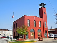
Bremen is a town in German Township, Marshall County, Indiana, United States. The population was 4,696 at the 2020 census.

<span class="mw-page-title-main">La Paz, Indiana</span> Town in the United States

LaPaz is a town in North Township, Marshall County, Indiana, United States. The population was 475 at the 2020 census, down from 561 in 2010.

<span class="mw-page-title-main">Kendallville, Indiana</span> City in Indiana, United States

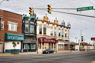
Kendallville is a city in Wayne Township, Noble County, in the U.S. state of Indiana. The population was 10,205 at the 2021 census.

<span class="mw-page-title-main">Montrose, Michigan</span> City in Michigan, United States

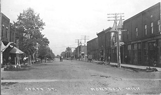
Montrose is a city in Genesee County in the U.S. state of Michigan. The population was 1,743 at the 2020 census. Once part of the surrounding Montrose Township, the city itself incorporated in 1980, and both are now administered autonomously. It is part of the Flint metropolitan area.

<span class="mw-page-title-main">Plymouth, Michigan</span> City in Michigan, United States

Plymouth is a city in Wayne County in the U.S. state of Michigan. A western suburb of Detroit, Plymouth is located roughly 27 miles (43.5 km) northwest of downtown Detroit, and 18 miles (29.0 km) northeast of Ann Arbor. As of the 2020 census, the city had a population of 9,370. It is surrounded by, but independent of, Plymouth Township.

<span class="mw-page-title-main">Huntsville, Missouri</span> City in Missouri, United States

Huntsville is a city in Randolph County, Missouri, United States. The population was 1,376 at the 2020 census. It is the county seat of Randolph County.

<span class="mw-page-title-main">Iron River, Wisconsin</span> Town in Wisconsin, United States

Iron River is a town in Bayfield County, Wisconsin, United States. The population was 1,123 at the 2010 census. The census-designated place of Iron River is located in the town. The unincorporated community of Topside is also located in the town.

<span class="mw-page-title-main">South Haven, Michigan</span> City in Michigan, United States

South Haven is a city in the U.S. state of Michigan. Most of the city is in Van Buren County, although a small portion extends into Allegan County. The population was 3,964 at the 2020 census.

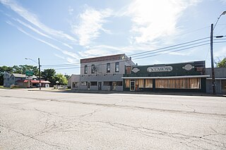
Tyner is an unincorporated community and census-designated place (CDP) in Polk Township, Marshall County, Indiana, United States. Originally named "Tyner City", it is named after Thomas Tyner, who died in 1880 and is buried in the town's cemetery.

References

  1. "2020 U.S. Gazetteer Files". United States Census Bureau. Retrieved March 16, 2022.
  2. 1 2 "U.S. Census website". United States Census Bureau . Retrieved January 31, 2008.
  3. "US Board on Geographic Names". United States Geological Survey. October 25, 2007. Retrieved January 31, 2008.
  4. "Find a County". National Association of Counties. Retrieved June 7, 2011.
  5. "US Gazetteer files: 2010, 2000, and 1990". United States Census Bureau. February 12, 2011. Retrieved April 23, 2011.
  6. Indiana Atlas & Gazetteer. Yarmouth, Me.: DeLorme. 1998. p. 20. ISBN   0-89933-211-0.
  7. "G001 - Geographic Identifiers - 2010 Census Summary File 1". United States Census Bureau. Archived from the original on February 13, 2020. Retrieved July 29, 2015.
  8. "NOWData – NOAA Online Weather Data". National Oceanic and Atmospheric Administration. Retrieved November 18, 2023.
  9. "Summary of Monthly Normals 1991–2020". National Oceanic and Atmospheric Administration. Retrieved November 18, 2023.
  10. "xmACIS2". National Oceanic and Atmospheric Administration. Retrieved November 19, 2023.
  11. "Census of Population and Housing". Census.gov. Retrieved June 4, 2015.
  12. "U.S. Census website". United States Census Bureau . Retrieved December 11, 2012.
  13. De Witt Clinton Goodrich & Charles Richard Tuttle (1875). An Illustrated History of the State of Indiana. Indiana: R. S. Peale & co. pp.  567.
  14. A Twentieth Century History of Marshall County, Indiana, Volume 1 By Daniel McDonald
  15. McDonald, Daniel (1908). A Twentieth Century History of Marshall County, Indiana, Volume 1. Lewis Publishing Company. p. 105.
  16. "Potawatomi Trail of Death". www.potawatomi-tda.org. Retrieved January 12, 2022.
  17. "Killing the Serpent Speedily" Indiana Historic Newspaper Digitization Project blog
  18. "Plymouth".
  19. "U.S. Census Bureau QuickFacts: South Bend city, Indiana". Census.gov. Retrieved July 20, 2022.
  20. "U.S. Census Bureau QuickFacts: Plymouth city, Indiana". Archived from the original on November 12, 2019. Retrieved November 12, 2019.
  21. "Home".
  22. "31 Dec 1969, Page 1 - The Culver Citizen at Newspapers.com". Newspapers.com. Retrieved April 5, 2019.
  23. Fried, Stephen (April 2017). "How the Liberty Bell Won the Great War". Smithsonian Magazine.
  24. Chandler Lighty (September 27, 2013). "A History of the Plymouth Republican". Hoosier State Chronicles: Indiana's Digital Newspaper Program. Retrieved January 12, 2022.
  25. Chandler Lighty (October 8, 2013). "Plymouth's Democratic Newspaper from 1856-1870 Digitized". Hoosier State Chronicles: Indiana's Digital Newspaper Program. Retrieved January 12, 2022.
  26. Marshall County Blueberry Festival History
  27. "National Register Information System". National Register of Historic Places . National Park Service. July 9, 2010.
  28. "National Register of Historic Places Listings". Weekly List of Actions Taken on Properties: 9/16/13 through 9/30/13. National Park Service. October 18, 2013.
  29. "National Register of Historic Places Listings". Weekly List of Actions Taken on Properties: 12/30/13 through 1/03/14. National Park Service. January 10, 2014.
  30. "We Are Sorry!".
  31. 1 2 "Map and Brochure" (PDF). Plymouth Park and Recreation Department. Archived from the original (PDF) on April 28, 2018.
  32. "Archived copy" (PDF). Archived from the original (PDF) on July 22, 2017. Retrieved November 12, 2019.{{cite web}}: CS1 maint: archived copy as title (link)
  33. "History". Blueberry Festival.
  34. "Indiana public library directory" (PDF). Indiana State Library. Archived from the original (PDF) on February 18, 2017. Retrieved March 10, 2018.
  35. Mission Statement (n.d.). Retrieved from http://www.plymouth.lib.in.us/home.aspx
  36. "Frequently Asked Questions".
  37. "Passafire". Passafiretheband.com. July 18, 2013. Retrieved July 20, 2022.
  38. Kizer, Noble E. (n.d.). Retrieved from https://www.indiana-football.org/?q=node/443
  39. Steve Yoder. (2019, January 04). Retrieved January 28, 2019, from https://en.m.wikipedia.org/wiki/Steve_Yoder
  40. Steve Yoder Coaching Record. (n.d.). Retrieved January 28, 2019, from https://www.sports-reference.com/cbb/coaches/steve-yoder-1.html
  41. Scott Skiles. (n.d.). Retrieved from http://www.nba.com/coachfile/scott_skiles/
  42. Morgan Uceny. (n.d.). Retrieved from http://www.usatf.org/Athlete-Bios/Morgan-Uceny.aspx#tab-events Archived 2016-12-02 at the Wayback Machine